快速概述: 卡拉特佩—阿斯兰塔什(Karatepe-Aslantaş) 是一座俯瞰奥斯曼尼耶省杰伊汉河谷的设防 新赫梯(晚期赫梯)卫城,由阿达纳瓦(希亚瓦)城邦的国王 阿扎提瓦达(Azatiwada) 于 公元前 8 世纪 建造。该址因其 双语铭文——迄今发现的最长的腓尼基文与卢维语象形文字平行文本——而享誉世界,这一铭文成为破译安纳托利亚象形文字的关键。两座纪念性城门两侧排列着精美雕刻的玄武岩浮雕,描绘狮子、斯芬克斯、宴饮场景和神话人物。卡拉特佩—阿斯兰塔什自 1960 年代起即为露天博物馆,其铭文于 2025 年被列入 联合国教科文组织世界记忆名录。
目录
- 为什么卡拉特佩—阿斯兰塔什重要
- 地理与环境
- 历史背景
- 阿扎提瓦达王与阿达纳瓦王国
- 双语铭文
- 纪念性城门
- 雕塑浮雕
- 防御体系
- 发现与发掘
- 哈莱特·钱贝尔与赫尔穆特·博塞特
- 卢维语象形文字的破译
- 联合国教科文组织的认定
- 露天博物馆
- 游客信息
- 常见问题
- 参考资料与延伸阅读
为什么卡拉特佩—阿斯兰塔什重要
卡拉特佩—阿斯兰塔什在古代近东研究史上占据独一无二的地位。其 双语铭文——以 腓尼基字母文字 与 卢维语象形文字 两种文字呈现同一篇王室文本——为破译安纳托利亚象形文字提供了决定性的钥匙,正如罗塞塔石碑解开了埃及象形文字之谜。在卡拉特佩之前,学者只能阅读公元前 2 千纪至 1 千纪在安纳托利亚和叙利亚北部使用的卢维象形文字文本的零碎片段。这一发现之后,整个语料库变得可以解读。
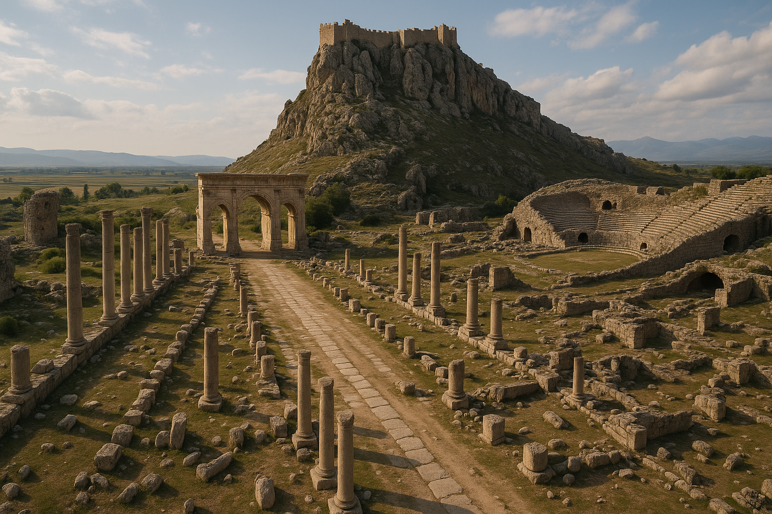
除铭文学价值之外,卡拉特佩还作为土耳其保存最完好的 新赫梯设防聚落 之一而具有重要意义。两座纪念性城门连同其雕刻着狮子、斯芬克斯、宴饮场景与神话叙事的玄武岩立板(orthostat),大部分仍保留在原位——这种罕见的情况使访客得以体验一座几乎按其原本设计呈现的晚期铁器时代入口建筑群。
铭文本身记录了书写史上的一个关键时刻:从音节文字(楔形文字与象形文字)向 字母文字(腓尼基文,及随后的希腊文)的过渡。卡拉特佩的腓尼基文本是已知最长的腓尼基文铭文之一,证明字母文字识读已传入安纳托利亚。
2025 年,这些铭文被列入 联合国教科文组织世界记忆国际名录,以表彰其对书写史所具有的全球意义。
地理与环境
卡拉特佩位于俯瞰杰伊汉河(古代的皮拉穆斯河,Pyramus)的一处 森林覆盖的山顶,正处该河经阿斯兰塔什水坝区域狭窄峡谷穿出托罗斯山脉之处,位于奥斯曼尼耶省 卡迪尔利东北约 23 公里 处。
这一战略位置一目了然:卫城扼守着从西利西亚沿海平原进入内陆高地的河流通道。任何在地中海低地与安纳托利亚高原之间往来的交通——无论军事、商业还是畜牧——都必须经过此地。阿扎提瓦达的铭文明确将这座要塞描述为「抵御来自北方的劫掠」的屏障。
周围地景是地中海沿海区域与大陆性内陆之间的过渡带。山丘上覆盖着 松树和马基林(maquis),杰伊汉河谷提供了肥沃的谷底。阿斯兰塔什水坝(1980 年代建造)如今淹没了下游谷地的一部分,但卫城山丘仍远高于水位。
历史背景
新赫梯时期
赫梯帝国约于 公元前 1180 年 崩溃之后,安纳托利亚东南部与叙利亚北部的政治格局碎裂成一系列小王国的拼合体,通常被称为 新赫梯(或叙利亚—赫梯)诸国。这些王国——包括卡尔凯美什(Carchemish)、萨马尔(Zincirli)、古尔古姆(Gurgum)、奎(Que)以及阿达纳瓦——在保留赫梯文化、语言与艺术传统元素的同时,也吸收了阿拉米、腓尼基与亚述的影响。
后来成为卡拉特佩领地的地区属于 阿达纳瓦(也称希亚瓦,Hiyawa)王国,其中心位于西利西亚平原——大致是今日阿达纳与楚库罗瓦东部的地区。阿达纳瓦保持独立或半独立状态,直至公元前 8 世纪末的亚述远征。
铁器时代的西利西亚
西利西亚平原是古代近东农业最富饶的地区之一。对河谷与山口的控制使该地区的新赫梯王国变得富庶并具有重要战略地位。亚述、乌拉尔图、弗里吉亚以及本地诸国之间的竞争塑造了公元前 8 世纪与公元前 7 世纪的政治史。
阿扎提瓦达王与阿达纳瓦王国
这座卫城由 阿扎提瓦达(Azatiwada,也作 Azatiwataš 或 Azatiwatas)建造,他作为阿达纳瓦国王阿瓦里库(Awariku)麾下的一座要塞城邦的「领主」进行统治。阿扎提瓦达的铭文——新赫梯世界中最为详尽的王室文本之一——揭示了一种复杂的政治自我表述:
- 他自称 「巴力(Ba'al)所祝福者」,是风暴神的仆人
- 他将自己描述为阿瓦里库王(在亚述文献中作 Urikki)的忠诚臣属
- 他将自己塑造为为阿达纳瓦土地带来 和平、繁荣与农业丰饶 的功勋者
- 他声称 扩张了王国的疆界,使粮仓满盈
- 他兴建了要塞城邦 阿扎提瓦塔亚(Azatiwataya)(阿扎提瓦达之城),以保护平原免受北方入侵者侵扰
- 他召唤 神明的诅咒,针对任何毁损其铭文或更改其名讳之人
文本因其自我辩白的修辞而引人注目,这种修辞既呼应赫梯王室铭文的宣传模式,也呼应腓尼基王室献辞的传统。阿扎提瓦达将自己呈现为一位好牧人,以强健的统治带来祝福。
年代讨论
阿扎提瓦达的在位年代尚有争议。大多数学者将其置于 公元前 8 世纪末(约公元前 740—前 710 年),正值亚述对该地区的压力日趋加剧之时。阿瓦里库(Urikki)在亚述文献中作为臣服于提格拉特帕拉沙尔三世(Tiglath-Pileser III)的附庸于公元前 738 年前后被记载。
双语铭文
卡拉特佩双语铭文是 已知最长的腓尼基文与卢维象形文字平行文本。同一王室宣言以两种文字出现在卫城两座纪念性城门两侧的立板(orthostat,竖立的石板)上。
腓尼基文文本
腓尼基文版本以标准的 西北闪米特字母文字 书写——22 个辅音字母,从右至左书写。它是古代世界已知最长的腓尼基文铭文之一,证明腓尼基字母文字在远离黎凡特海岸的西利西亚地区仍在活跃使用。
卢维象形文字文本
象形文字版本使用了被称为 卢维象形文字(旧称「赫梯象形文字」)的本土安纳托利亚文字体系。这种象形/表意文字自青铜时代晚期至铁器时代被用于整个安纳托利亚与叙利亚北部的纪念性王室铭文。
双语铭文为何具有决定性意义
在卡拉特佩之前,卢维象形文字的破译进展缓慢。学者们能识别一些表意符号,但无法在语音上确认其读音。卡拉特佩双语铭文提供了:
- 专有名词 在两种文字中均出现,确认了语音值
- 平行段落,确立了此前未知的象形文字符号的含义
- 语法结构,可将卢维语与已知的腓尼基语语法进行比较
- 表意符号,其含义现在可通过上下文得以确定
其影响堪比罗塞塔石碑在埃及学中的作用:它将一种部分被理解的文字转化为大体可读的文字。在卡拉特佩文本发表后的数年内,整个安纳托利亚与叙利亚地区卢维象形文字铭文的语料库便为学者所通晓。
纪念性城门
卡拉特佩有两座纪念性城门——北门 与 南门——每座由一条通道组成,两侧排列着刻有铭文与浮雕的立板(竖立雕刻的石板)。
北门
北门是两座中更为精致的一座。其特征包括:
- 成对的狮子雕塑 矗立于外入口两侧——这些狮子昂首向前、张口而立,既作为守护者,也作为王权的象征
- 立板,其中腓尼基文文本在左侧墙上,卢维象形文字文本在右侧墙上
- 浮雕板,描绘宴饮场景、乐师、动物搏斗以及神话叙事
- 内入口处的 斯芬克斯 形象
南门
南门与北门相辅相成,特征包括:
- 入口处 成对的狮子雕塑(即「阿斯兰塔什」——狮石,土耳其语遗址名的由来)
- 带有铭文与人物场景的额外 浮雕立板
- 守护神像与装饰板
两座城门都朝向控制自下方河谷进入卫城的通道。两座配有铭文与雕刻的城门成对设置在新赫梯建筑中颇为罕见,这表明阿扎提瓦达希望从任一方向进入的访客都能见到他的王室宣言。
雕塑浮雕
卡拉特佩的玄武岩立板上保留了现存最为生动的 新赫梯浮雕雕塑 之一。题材包括:
宴饮与节庆场景
- 一位国王或贵族坐于 宴饮桌前,乐师演奏里拉琴、双管笛与鼓
- 仆从端送食物与饮品
- 舞者与杂技演员正在表演
这些场景很可能描绘了阿扎提瓦达在其铭文中宣称设立的 宗教节庆,并为铁器时代的音乐、饮食文化与宫廷生活提供了珍贵的视觉证据。
动物场景
- 狮子 攻击公牛——一个经典的近东母题,象征王权战胜混乱
- 猎鹿 ——国王或战士追逐猎物
- 山羊与牛——可能代表阿扎提瓦达声称带来的农业繁荣
神话与宗教场景
- 类似贝斯(Bes)的形象——源自埃及图像学的矮人式护佑神祇,显示出国际文化交流的广度
- 风暴神图像——与铭文所强调的风暴神保护一致
- 一位 哺乳母亲的形象——可能是女神或生育象征
- 带翼日轮——一种象征神圣王权的近东符号
守护神像
- 斯芬克斯——人首带翼之狮,与亚述、赫梯及黎凡特传统共有的母题
- 狮子——置于城门入口处作为超自然守护者
艺术风格融合了 赫梯、亚述、腓尼基与北叙利亚 的元素,反映了铁器时代西利西亚国际化的文化环境。
防御体系
卫城占据了山丘整个顶部,由一道 环形城墙 围合,配有塔楼和两座纪念性城门:
- 城墙: 以粗石筑成、内部夯土填心,顺山顶轮廓而建
- 塔楼: 沿城墙间隔分布的方形突出塔楼
- 城门: 两座精心设计的入口(北门与南门)是仅有的通道
- 内部: 围合区域内有住宅建筑、储藏设施,以及可能的行政建筑或小型宫殿
要塞被设计为一座 边境防御工事,保护西利西亚平原免受经由托罗斯山口而来的劫掠。其高耸的位置可俯瞰河谷及周围地势,视野极佳。
发现与发掘
最早报告(1890 年)
德国学者 费利克斯·冯·吕斯昌(Felix von Luschan) 在邻近的津吉尔利(Zincirli,即萨马尔,Sam'al)进行发掘时收到关于卡拉特佩雕刻石材的报告,并在其著作中提及该址。然而,偏远的位置与茂密的森林覆盖使其无法立即进行调查。
重新发现(1946 年)
决定性的重新发现发生在 1946 年,当时土耳其教师 埃克雷姆·库什库(Ekrem Kuşçu) 将这些雕刻石材报告给考古学家 赫尔穆特·特奥多尔·博塞特(Helmuth Theodor Bossert)(1889—1961),一位在伊斯坦布尔大学工作的德国出生的学者。博塞特与其助手 哈莱特·钱贝尔(Halet Çambel)(1916—2014)一同访问了该址,并立即认识到双语铭文的重要性。
发掘(1947—1957 年)
系统性发掘于 1947 至 1957 年 间在博塞特主持下进行,钱贝尔担任田野主任。团队:
- 揭露了两座纪念性城门及其原位立板
- 完整记录了双语铭文
- 发掘了防御城墙与内部建筑
- 发表了让近东研究界为之震动的初步报告
该发掘的一大特点是决定将浮雕立板 保留在原始位置,而非将其移至博物馆——这一就地保存的开创性做法在当时颇为超前。
哈莱特·钱贝尔与赫尔穆特·博塞特
与卡拉特佩关联最密切的两位学者是:
赫尔穆特·特奥多尔·博塞特(1889—1961)
一位德国艺术史学家与近东专家,他逃离纳粹德国并定居土耳其。博塞特担任伊斯坦布尔大学教授席位,对土耳其考古学的发展起到了关键作用。他立刻把握住了卡拉特佩双语铭文的意义,并将其晚年的岁月奉献于该铭文的研究与出版。
哈莱特·钱贝尔(1916—2014)
土耳其最杰出的考古学家之一——也是第一位参加 奥运会 比赛的土耳其女性(击剑,1936 年柏林)。钱贝尔自 1947 年起担任卡拉特佩的田野主任,于 1961 年博塞特去世后接手发掘工作,并继续在该址工作了数十年。她在建立 露天博物馆 方面发挥了关键作用,并在 1980 年代奋力保护该址免受阿斯兰塔什水坝建设的破坏。
钱贝尔与卡拉特佩的关联跨越了 60 余年——这是考古学史上考古学家与单一遗址之间最长的持续关联之一。她获得了众多奖项,包括 2004 年因其保护工作而颁发的克劳斯亲王奖(Prince Claus Award)。
卢维语象形文字的破译
卡拉特佩双语铭文对卢维语象形文字破译的影响怎么强调都不为过:
卡拉特佩之前
- 卢维语象形文字自 19 世纪以来就从安纳托利亚与叙利亚各地的纪念物中为人所知
- 一些表意符号可以试探性地解读,但语音值仍不确定
- 诸如 伊格内斯·盖布(Ignace Gelb)、皮耶罗·梅里吉(Piero Meriggi) 与 埃马纽埃尔·拉罗什(Emmanuel Laroche) 等学者的关键突破已识别出基本结构特征
- 但没有双语铭文,完全破译仍属不可能
卡拉特佩之后
- 腓尼基文平行文本提供了上下文框架,得以确认并修正早期解读
- 专有名词,如阿扎提瓦达、阿瓦里库以及地理术语,可在两种文字间相互比对
- 在 5 至 10 年内,破译工作从部分推进至基本完成
- 整个卢维象形文字铭文语料库——从哈图沙到卡尔凯美什,从阿勒颇到卡拉曼——皆变得可读
对书写史的意义
这些铭文也阐明了一个关键过渡:从音节文字体系(楔形文字与象形文字)向 字母文字(腓尼基文,及随后的希腊文)的过渡。卡拉特佩展现了这两种体系在一座纪念物上的共存,反映了腓尼基字母正在通过东地中海传播并取代更古老、更复杂文字的那一时刻。
联合国教科文组织的认定
2025 年,卡拉特佩—阿斯兰塔什铭文被列入 联合国教科文组织世界记忆国际名录,与古登堡圣经、贝叶挂毯以及法国大革命档案等具有全球意义的文献并列。
联合国教科文组织的引述承认这些铭文为:
- 已知最古老的 腓尼基文 与 卢维文 长文本之一
- 破译安纳托利亚象形文字的关键
- 由音节文字向字母文字过渡这一关键时刻的证据
- 古代东地中海跨文化交流的丰碑
卡拉特佩—阿斯兰塔什也被列入土耳其的 联合国教科文组织世界遗产预备名录,因其考古与艺术史意义而获得提名。
露天博物馆
卡拉特佩—阿斯兰塔什自 1960 年代起作为 露天博物馆 运作,秉承哈莱特·钱贝尔开创的保护理念。主要特征:
- 浮雕立板 仍位于两座城门的原始位置——访客所见的正是阿扎提瓦达在 2700 年前所放置之处
- 保护性 遮蔽棚 覆盖最脆弱的雕塑
- 步行路径连接北门、南门与防御城墙
- 卡拉特佩—阿斯兰塔什国家公园 内的山顶环境提供了森林环绕、富有氛围的环境
- 信息牌讲解铭文、浮雕与历史背景
这种就地展示使卡拉特佩在新赫梯遗址中显得尤为生动。与立板被陈列于画廊中的博物馆不同,此处的雕塑仍嵌于它们所设计的建筑语境之中。
游客信息
位置: 卡拉特佩—阿斯兰塔什国家公园,位于奥斯曼尼耶省卡迪尔利东北约 23 公里处。
交通方式: 自卡迪尔利驾车前往(30 分钟)或自奥斯曼尼耶(45 分钟)。穿越国家公园的道路已铺设。无公共交通直达该址——需要私家车或出租车。
开放时间: 每日开放,通常为 08:00—17:00(冬季)或 08:00—19:00(夏季)。在某些国家假日闭馆。
门票: 收取门票费用。博物馆通行卡有效。
参观时长: 1.5—2.5 小时即可全面游览,包括两座城门、城墙以及山顶观景点。
设施: 设有信息牌的小型游客中心。国家公园内设有野餐区。食品与饮品设施有限——请自带补给。
联合参观:
- 卡迪尔利——当地集镇(30 分钟)
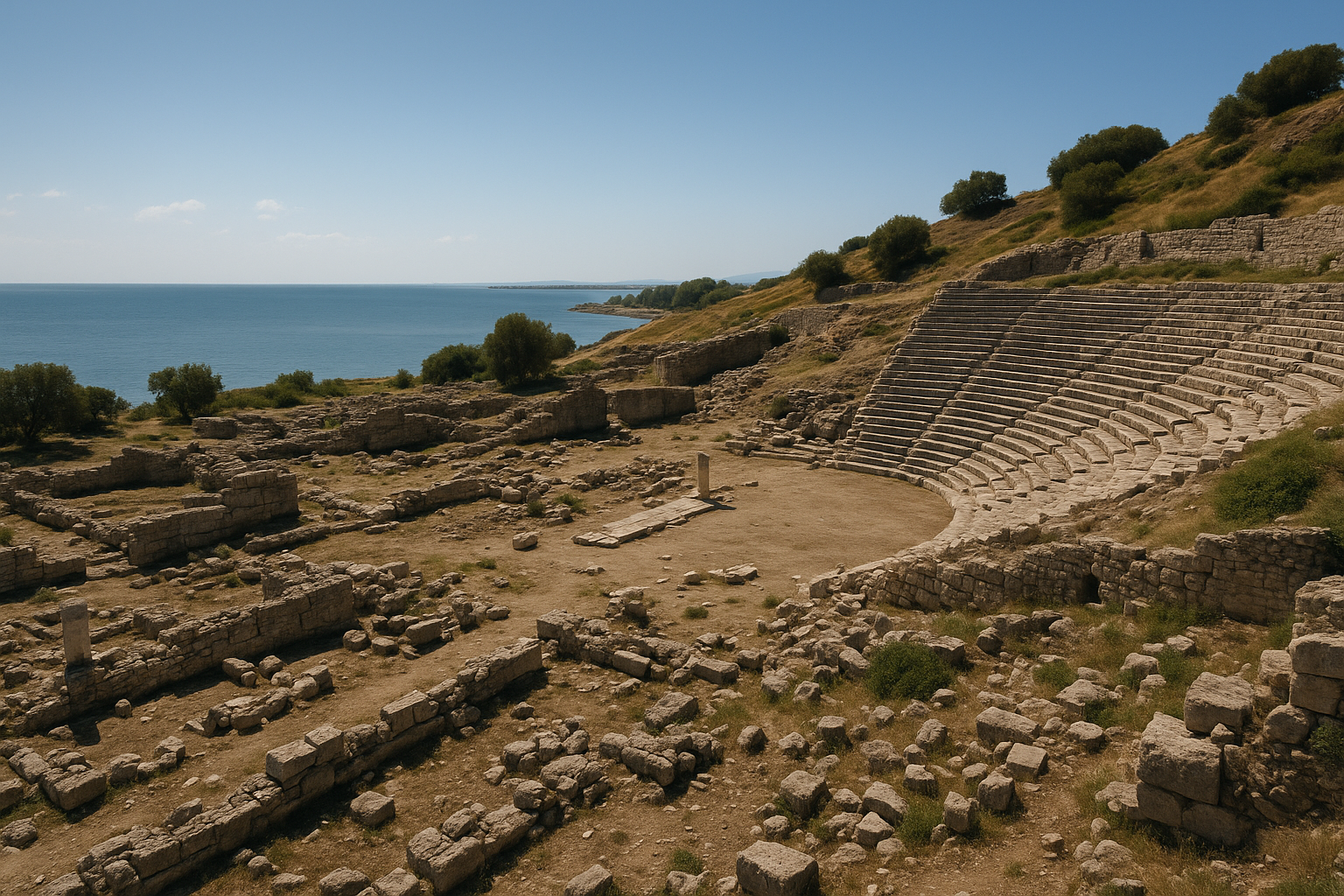
- 卡斯塔巴拉(希耶拉波利斯,Hierapolis)——拥有柱廊街与城堡的罗马城市(南 25 公里)
- 杜吕克(多利刻,Doliche)——朱庇特·多利刻努斯的圣所(东 90 公里)
- 阿纳瓦尔扎(阿纳扎尔博斯,Anazarbos)——壮观的罗马/中世纪城市(西南 60 公里)
贴士:
- 该址位于国家公园内——森林环境优美,尤其春秋时节
- 山坡步行路径请穿舒适的步行鞋
- 北门最为壮观——请在那里多花时间
- 清晨或傍晚的光线最适合拍摄浮雕
- 夏季河边可能有蚊虫问题——请带驱蚊用品
- 若无准备,双语铭文可能难以辨读——请事先研习文本或借助信息牌
常见问题
「卡拉特佩—阿斯兰塔什」是什么意思? 土耳其语中「卡拉特佩」意为「黑色山丘」。「阿斯兰塔什」意为「狮石」,指城门处的狮子雕塑。
为什么双语铭文如此重要? 它提供了破译卢维象形文字的关键——这是一种千余年间在安纳托利亚与叙利亚北部用于纪念性铭文的文字。其作用与罗塞塔石碑对于埃及象形文字的作用相同。
阿扎提瓦达是谁? 一位新赫梯统治者,他在阿达纳瓦(希亚瓦)国王阿瓦里库的权威之下治理一座要塞城邦。他在公元前 8 世纪末建造了卡拉特佩卫城,以保护西利西亚平原免受北方劫掠。
原始浮雕是否仍在原位? 是的——这是该址最引人注目的特征之一。带有浮雕与铭文的立板仍保留在两座城门的原始位置,由保护性遮蔽棚覆盖。
卡拉特佩—阿斯兰塔什是联合国教科文组织世界遗产吗? 其铭文于 2025 年被列入 联合国教科文组织世界记忆名录。考古遗址本身则列于土耳其联合国教科文组织世界遗产 预备名录 之上。
与其他新赫梯遗址相比如何? 卡拉特佩因其双语铭文与原位保存而独具特色。作为比较:津吉尔利(萨马尔) 拥有规模更大的建筑,卡尔凯美什 拥有更精致的雕塑,而 艾因·达拉(Ain Dara) 拥有保存更好的神庙——但没有一处拥有可比的双语文本。
我可以将其与其他古代遗址结合参观吗? 可以——卡斯塔巴拉、阿纳瓦尔扎和杜吕克均在一日游范围内。东西利西亚地区古代遗址的密集程度极为非凡。
防御工事测量与结构数据
卡拉特佩—阿斯兰塔什卫城已经过精确测绘,提供了详细的尺寸与结构数据。
卫城平面
| 参数 | 测量值 |
|---|---|
| 卫城占地 | 196 x 376 米(约 7.4 公顷) |
| 朝向 | 东北—西南,与杰伊汉河走向及阿克约尔商队路线一致 |
| 城墙构造 | 粗石筑成、内部夯土填心,顺山顶自然轮廓而建 |
| 防御塔楼(规划) | 环形城墙上 34 座方形棱堡 |
| 防御塔楼(已确认) | 经发掘确认 28 座棱堡 |
| 塔楼间距 | 沿城墙间距规整,约 18—20 米 |
| 城门建筑群 | 2 座(北门与南门),仅有的通道 |
棱堡每隔 18—20 米的规整间距表明了系统性的军事工程规划。六座未定位的塔楼可能因侵蚀或后期扰动而被毁,或者它们可能代表了规划但未完成的建造。
立板程式
两座城门通道的内壁均排列着 玄武岩立板——竖立的雕刻石板,支撑泥砖上层结构的下方石材层。玄武岩取代当地易得的石灰岩,是因其 耐久性、抗风化能力以及更深色的视觉效果,赋予铭文与浮雕以纪念性的庄严感。
| 城门 | 铭文文字(左壁) | 铭文文字(右壁) | 浮雕板数量 | 守护神像 |
|---|---|---|---|---|
| 北门 | 腓尼基字母文字 | 卢维象形文字 | 多块人物与叙事立板 | 成对昂首狮(外入口);斯芬克斯(内入口) |
| 南门 | 腓尼基文/卢维文 | 卢维文/腓尼基文 | 额外人物与叙事立板 | 成对狮子雕塑(即「阿斯兰塔什」——狮石) |
北门的浮雕程式包括 配有桨手的桨船场景——一种在内陆山地要塞中出人意料的海事母题,可能反映了阿达纳瓦经由杰伊汉河谷接入地中海贸易的事实。其他浮雕板描绘 战士与狮子搏斗、树下哺乳婴儿的母亲,以及带有带翼日轮的 赫梯太阳神。
铭文分析:腓尼基文与卢维文文本
双语铭文不仅仅是一份翻译;它代表了 古代近东与地中海地区已知最早的建筑纪念物上的双语叙事。两种文字传达了阿扎提瓦达的同一篇王室宣言,但在侧重点与神明召唤上存在细微差异,反映了各自语言不同的文化受众。
腓尼基文文本统计
| 参数 | 详情 |
|---|---|
| 文字类型 | 西北闪米特字母文字(22 个辅音字母,从右至左) |
| 地位 | 古代世界已知 现存最长的腓尼基文铭文 |
| 语言 | 标准腓尼基语,带有一些卢维语借词 |
| 文化意义 | 证明腓尼基字母文字识读在远离黎凡特海岸、深入安纳托利亚之处仍在活跃使用 |
卢维象形文字文本统计
| 参数 | 详情 |
|---|---|
| 文字类型 | 安纳托利亚象形文字(象形—表意—音节的混合系统) |
| 地位 | 任何遗址中已知 现存最长的卢维象形文字铭文 |
| 对破译的影响 | 确认了数十个此前不确定符号的语音值;使从哈图沙到阿勒颇的整个卢维象形文字语料库得以解读 |
| 经双语确认的关键名称 | 阿扎提瓦达、阿瓦里库(Urikki)、巴力、风暴神、阿达纳瓦的地理术语 |
卡拉特佩所呈现的过渡——音节文字(楔形文字与象形文字)与字母文字(腓尼基文)在同一座纪念物上共存——记录了字母文字识读正通过东地中海传播并开始取代更古老、更复杂的书写系统的那一历史时刻。
发掘年表与保护史
| 年份 | 事件 | 主要人物 |
|---|---|---|
| 1890 年 | 费利克斯·冯·吕斯昌(在邻近的津吉尔利/萨马尔工作)收到关于卡拉特佩雕刻石材的报告;记录该址但未发掘 | 冯·吕斯昌 |
| 1946 年 | 土耳其教师 埃克雷姆·库什库 向赫尔穆特·博塞特报告雕刻石材;博塞特与哈莱特·钱贝尔访问该址并识别出双语铭文 | 博塞特、钱贝尔、库什库 |
| 1947—1957 年 | 在博塞特主持下进行系统性发掘,钱贝尔担任田野主任;两座城门连同原位立板被揭露;防御城墙与内部建筑被发掘 | 博塞特、钱贝尔 |
| 1960 年代 | 露天博物馆设立;立板保留于原始位置,配以保护性遮蔽棚——一项开创性的就地保护决策 | 钱贝尔 |
| 1961 年 | 博塞特去世;钱贝尔接任全面主持 | 钱贝尔 |
| 1980 年代 | 阿斯兰塔什水坝建设威胁河谷;钱贝尔奔走呼吁保护该址 | 钱贝尔 |
| 2003 年 | 钱贝尔与阿斯勒·厄兹亚尔(Aslı Özyar)合著的 Karatepe-Aslantaş: Azatiwataya(美因茨)出版——该址的权威性专著 | 钱贝尔、厄兹亚尔 |
| 2004 年 | 钱贝尔因文化保护工作获得 克劳斯亲王奖 | 钱贝尔 |
| 2014 年 | 哈莱特·钱贝尔逝世,享年 97 岁,与该址保持了 60 余年的持续关联 | — |
| 2025 年 | 铭文被列入 联合国教科文组织世界记忆国际名录 | — |
哈莱特·钱贝尔与卡拉特佩 60 余年 的关联,代表了考古学史上考古学家与单一遗址之间最长的持续关系之一。她决定将立板保留在原位而非移至博物馆,这一做法在当时颇具争议,但如今被公认为露天考古展示的典范。
参考资料与延伸阅读
- 赫尔穆特·特奥多尔·博塞特,Karatepe: A Preliminary Report(伊斯坦布尔,1950)
- 哈莱特·钱贝尔与阿斯勒·厄兹亚尔,Karatepe-Aslantaş: Azatiwataya(美因茨,2003)
- J. 大卫·霍金斯,Corpus of Hieroglyphic Luwian Inscriptions,卷 I—III(柏林,2000)
- 联合国教科文组织世界记忆名录——卡拉特佩—阿斯兰塔什铭文(2025)
- 联合国教科文组织世界遗产预备名录——卡拉特佩—阿斯兰塔什考古遗址
- 维基百科,「Karatepe」与「Karatepe bilingual」——概述与参考书目
- 科奇大学图书馆数字馆藏,「The Fortress Azatiwatas: Karatepe-Aslantaş」
- MuseoPics,「The Bilingual Citadel: The Sculpted Legacy of Karatepe-Aslantaş」