ملخّص سريع: تقع مدينة إريثراي القديمة (باليونانية: Ἐρυθραί، "المدينة الحمراء") قرب قرية إلدري الحديثة، على الساحل الشمالي الشرقي لشبه جزيرة تشيشمه، في محافظة إزمير. كانت إحدى المدن الأيونية الاثنتي عشرة، تقع قبالة جزيرة خيوس (جزيرة ساكيز)، وكانت تخدم بوصفها ميناءً ومركزًا تجاريًا مهمًا طوال الفترتين العتيقة (الأركية) والكلاسيكية.
جدول المحتويات
- نظرة عامّة
- الخلفية التاريخية
- علم الآثار والتخطيط العمراني
- تجربة الزائر
- قصة قصيرة من الماضي
- ملاحظات سفر عملية
- الأسئلة الشائعة
- المصادر
نظرة عامّة
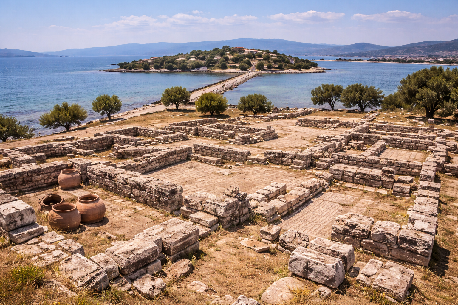
تقع مدينة إريثراي القديمة (باليونانية: Ἐρυθραί، "المدينة الحمراء") قرب قرية إلدري الحديثة، على الساحل الشمالي الشرقي لشبه جزيرة تشيشمه، في محافظة إزمير. كانت إحدى المدن الأيونية الاثنتي عشرة، تقع قبالة جزيرة خيوس (جزيرة ساكيز)، وكانت تخدم بوصفها ميناءً ومركزًا تجاريًا مهمًا طوال الفترتين العتيقة (الأركية) والكلاسيكية.
صُمّمت هذه الصفحة للزوّار الفعليين: ليست فقط لشرح ماهية هذا المكان، بل أيضًا لبيان أهمّيته وكيفية اختباره بصورة ذات معنى.
الخلفية التاريخية
تقع مدينة إريثراي القديمة (باليونانية: Ἐρυθραί، "المدينة الحمراء") قرب قرية إلدري الحديثة، على الساحل الشمالي الشرقي لشبه جزيرة تشيشمه، في محافظة إزمير. كانت إحدى المدن الأيونية الاثنتي عشرة، تقع قبالة جزيرة خيوس (جزيرة ساكيز)، وكانت تخدم بوصفها ميناءً ومركزًا تجاريًا مهمًا طوال الفترتين العتيقة (الأركية) والكلاسيكية.
(المصدر: مديرية الثقافة والسياحة في إزمير – "إريثراي (إلدري)";
المتاحف التركية – "موقع إريثراي الأثري";
ويكيبيديا – "إريثراي")
أُسّست إريثراي في حدود القرن الثامن ق.م واشتُهرت بـالنبيذ والتين وعبادات النبوءة. ويذكر الكتّاب القدماء أمثال سترابون وبوسانياس وجود عرّافة (سيبيلة) في إريثراي، كانت نبوءاتها معروفة في أرجاء البحر المتوسط القديم. وإلى جانب دلفي وديديما، كان حرَم إريثراي أحد أكثر مراكز النبوءة الثلاثة احترامًا في العالم الإغريقي.
(المصدر: ويكيبيديا – "إريثراي";
قاموس أكسفورد الكلاسيكي – مدخل "إريثراي")
ازدهرت المدينة بوصفها عضوًا في الاتحاد الأيوني، إذ كانت تسيطر على أراضٍ خصبة ومرفأ طبيعي ممتاز. وعلى غرار كثير من المدن الأيونية، دُمّرت خلال الفتح الفارسي (منتصف القرن السادس ق.م) ثمّ استعادت استقلالها في عهد الإسكندر الأكبر في القرن الرابع ق.م. وفي الفترة الهلنستية، أُعيد بناء إريثراي بمخطّط شبكي، مع أغورا ضخمة ومسرح ومعابد وأسوار مدينة. واستمرّت في الازدهار في ظلّ الرومان، محافظةً على مكانتها بوصفها ميناءً إقليميًا حتى القرن الثالث الميلادي.
(المصدر: المتاحف التركية – "موقع إريثراي الأثري";
المدن القديمة في تركيا – "إريثراي";
ويكيبيديا – "إريثراي")
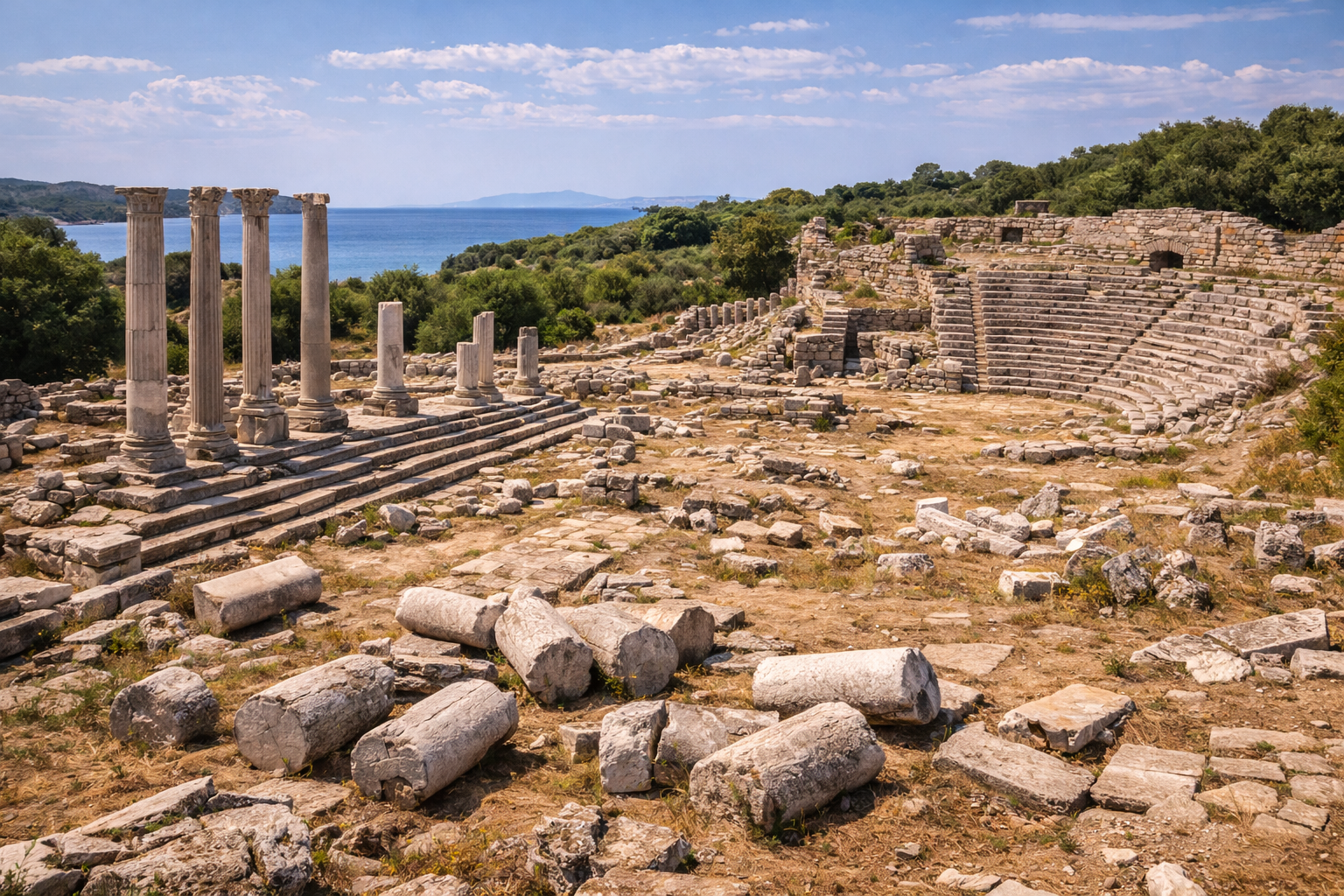
تشمل المعالم الرئيسية المرئية اليوم المسرح، المنحوت في سفح التلّ مع إطلالات على بحر إيجة؛ ومدرّج المعابد ببقايا أضرحة لـأثينا بولياس وأبولو وهرقل؛ والأغورا والمقابر ومقاطع من أسوار التحصين المبنية بأسلوب البناء المضلّع. وتنقيبات جامعة أنقرة منذ...
وراء الأطلال المرئية، تأتي القيمة التاريخية لهذا الموقع من الاستمرارية: تغيّر السلطات وتغيّر الوظائف الحضرية وتغيّر الأساليب التي استخدم بها الناس الفضاء العامّ عبر القرون.
علم الآثار والتخطيط العمراني
عند قراءة هذا الموقع في مكانه، ركّز على ثلاث طبقات:
- طبقة التنقّل: الشوارع والأبواب والمدرّجات والمرفأ أو وصلات المنحدر
- الطبقة العامّة: المسارح والأغوار والحمّامات والمعابد والمساحات الإدارية
- طبقة البنية التحتية: أنظمة المياه والجدران ومناطق التخزين والعمارة الخدمية
تساعد هذه الطريقة الزوّار والباحثين على فهم المدينة بوصفها نظامًا حيًا لا معالم منفصلة.
تجربة الزائر
عادةً ما تتضمّن الزيارة عالية الجودة:
- نقطة توجيه أولى (نقطة إطلالة أو حافة أكروبوليس أو محور مركزي)
- مرور بأبرز منشأة في الموقع
- مشي أبطأ عبر فضاءات الحياة اليومية
- توقّف نهائي يربط الأطلال بالمشهد الطبيعي
يخلق هذا التسلسل سردًا تاريخيًا أقوى من الحركة السريعة "للتصوير فقط".
قصة قصيرة من الماضي
تخيّل وصولك إلى هنا في العصور القديمة عند شروق الشمس: العمّال يستعدّون لليوم، والمسافرون يدخلون عبر الطرق أو مسالك المرفأ، والتجّار يفتحون فضاءات التخزين، والعمارة العامّة قد بدأت بالفعل في تشكيل الحركة والطقوس. الحجارة التي تراها اليوم ليست أجسامًا صامتة؛ إنّها شذرات من تلك الإيقاعات اليومية المتكرّرة.
ملاحظات سفر عملية
- يُفضّل الربيع والخريف للراحة.
- في الصيف، تجنّب ذروة حرارة الظهيرة كلّما أمكن.
- ارتدِ حذاء مشي ثابتًا للتضاريس غير المستوية.
- خصّص وقتًا كافيًا (1.5–3 ساعات على الأقلّ) لمسار ذي معنى.
- تحقّق من شروط الوصول الحالية والتذاكر قبل المغادرة.
الأسئلة الشائعة
لماذا تُعدّ مدينة إريثراي القديمة (إلدري، إزمير) مهمّة؟
لأنّها تحفظ طبقات تاريخية متعدّدة وتساعد على تفسير الاستمرارية الثقافية الإقليمية في تركيا.
كم من الوقت ينبغي أن أقضي هنا؟
يقضي معظم الزوّار 1.5–3 ساعات؛ وقد تستغرق الزيارات المعمّقة نصف يوم.
هل يناسب هذا الموقع المسافرين الذين يخوضون تجربة الآثار لأوّل مرة؟
نعم. مع تخطيط أساسي، يناسب هذا الموقع الزوّار المبتدئين والمتمرّسين على حدّ سواء.
تسلسل التنقيب الزمني
| السنة / الفترة | النشاط | المدير / المؤسّسة |
|---|---|---|
| 1891 | أوّل مسح سطحي ورسم طبوغرافي | مسّاحون بحريون بريطانيون |
| 1964–1982 | أوّل حملة تنقيب منهجية | الأستاذ الدكتور أكرم أكورغال وحقّي غولتكين (جامعة أنقرة / متحف إزمير) |
| 1964–1982 | الكشف عن المسرح وقاعدة معبد أثينا بولياس وأسوار التحصين والمقابر | جودت بايبورتلوغلو (تخطيط الموقع) |
| 2006/2007–حتى الآن | حملة التنقيب الثانية | الأستاذة المشاركة الدكتورة عائشة غول أكالين أورباي (جامعة أنقرة) |
| 2010s | اكتشاف وتسجيل حرم كيبيلي الصخري بوصفه موقعًا أثريًا من الدرجة الأولى | فريق جامعة أنقرة |
أرست تنقيبات الجيل الأوّل (1964–1982) المخطّط الأساسي للموقع وكشفت عن المنشآت المعمارية الكبرى. وقد ركّزت تنقيبات الجيل الثاني، منذ 2006/2007 فصاعدًا، على المناطق المقدّسة والتسلسلات الخزفية والعلاقة بين حيّ المرفأ والمدينة العليا.
القياسات المعمارية للمنشآت الرئيسية
| المنشأة | الأبعاد / التفاصيل الرئيسية |
|---|---|
| معبد أثينا بولياس | قاعدة من القرن السادس ق.م؛ المرحلة الأولى تعود إلى النصف الثاني من القرن الثامن قبل الميلاد؛ النظام الأيوني؛ جدران القاعدة من الحجر الجيري المقطوع |
| المسرح | هلنستي، النصف الأوّل من القرن الثالث قبل الميلاد؛ كافيا منحوتة في سفح التلّ تواجه بحر إيجة؛ ديازوما مزدوجة؛ جدران الأناليما أُعيد بناؤها في الفترة الرومانية |
| أسوار التحصين | تقنية البناء المضلّع؛ سور يحيط بالأكروبوليس والمدينة السفلى؛ محيط كلّي مقدّر بنحو 3.5 كم |
| الأغورا | مخطّط مستطيل على المدرّج السفلي؛ أساسات أروقة (ستوا) على جانبَين على الأقلّ |
| حاجز المرفأ | بناء غارق ذو قلب من الحطام، يُرى في المياه الضحلة قبالة خيوس |
الأدلّة النقدية: نقود إريثراي
سكّت إريثراي النقود من الفترة العتيقة حتى الفترة الإمبراطورية الرومانية، ممّا يوفّر سجلًا نقديًا متواصلًا يمتدّ لأكثر من 800 عام.
| الفترة | المعدن | الوجه النموذجي | الظهر النموذجي | السمات البارزة |
|---|---|---|---|---|
| العتيقة (القرن السادس ق.م) | إلكتروم / فضّة | بيغاسوس | مربّع غائر | من أوائل المسكوكات الأيونية |
| الكلاسيكية (القرنان الخامس–الرابع ق.م) | فضّة / برونز | رأس هرقل | الهراوة والقوس والجعبة | الأيقونوغرافيا الهرقلية مهيمنة |
| الهلنستية (القرنان الثالث–الثاني ق.م) | برونز | رأس هرقل | الهراوة مع أسماء الحكّام | كتابات إغريقية: ERYTH أو ERY |
| الإمبراطورية الرومانية | برونز | صورة الإمبراطور | السيبيلة الإريثراية جالسة | السيبيلة مصوّرة بشعر مرصّع بمجوهرات متقن، محاطة بإطار |
ظهرت السيبيلة الإريثراية على النقود المدنية للفترة الرومانية، ممّا جعل إريثراي إحدى المدن القليلة جدًا التي صوّرت عرّافة بوصفها نمطًا رئيسيًا على ظهر النقد. ويعكس هذا الشهرة الدائمة لهذا الوحي حتى العصر الإمبراطوري.
السيبيلة الإريثراية وعبادة النبوءة
كانت سيبيلة إريثراي (Sibylla Erythraea) إحدى أشهر العرّافات في عالم البحر المتوسط القديم. وتذكر المصادر القديمة، بما فيها سترابون وبوسانياس وفارّو، بروزها:
- يُدرج بوسانياس (10.12.1–8) السيبيلة الإريثراية ضمن أقدم العرّافات وأكثرهنّ سلطة، إلى جانب سيبيلة دلفي
- يُقال إنّ السيبيلة تنبّأت بسقوط طروادة وقدوم الإسكندر
- في التقليد المسيحي، اعتُمدت السيبيلة الإريثراية بوصفها شاهدة وثنية على التوحيد؛ وتظهر في سقف كنيسة سيستينا لمايكل أنجلو (1508–1512)
- وقد جرى التعرّف على منطقة الحرم قرب معبد أبولو دلفينيون على الأكروبوليس بوصفها الموضع المرجّح لعبادة الوحي
تمثال الكوري وأبرز الاكتشافات
أسفرت التنقيبات حول معبد أثينا بولياس عن واحد من أهمّ المنحوتات العتيقة التي عُثر عليها في أيونيا:
- كوري إريثراي -- شخصية أنثوية مكسوّة (شابّة بفستان طويل)، يعود تاريخها إلى القرن السادس ق.م، تمثّل أحد الأمثلة النادرة الباقية للنحت الرخامي الأيوني العتيق
- تتبع الشخصية نمط الكوري الكلاسيكي: وقفة أمامية، بملابس متقنة من خيتون وهيماتيون، مع آثار طلاء متعدّد الألوان أصلي
- معروضة حاليًا في متحف إزمير الأثري
- تشمل الاكتشافات الإضافية من حرم المعبد نذورًا تيراكوتيّة عتيقة، ومشابك برونزية، وشذرات من تيراكوتا معمارية مرسومة
المصادر
- https://izmir.ktb.gov.tr/EN-240247/erythrai-ildiri.html
- https://www.turkishmuseums.com/museum/detail/2089-izmir-erythrai-archaeological-site/2089/1
- https://en.wikipedia.org/wiki/Erythrae
- https://oxfordre.com/classics/view/10.1093/acrefore/9780199381135.001.0001/acrefore-9780199381135-e-2847
- https://ancientcitiesturkey.com/en/erythrai
- https://arkeoloji.ankara.edu.tr/erythrai-kazisi/
- https://www.visitizmir.org/en/Destination/10303
- https://commons.wikimedia.org/w/index.php?search=Ancient+City+of+Erythrae&title=Special:MediaSearch&type=image
تحليل تاريخي متقدّم
التطبيق السياسي الطبقي
ينبغي تفسير مدينة إريثراي القديمة (إلدري، إزمير) من خلال تحوّلات السلطة السياسية، لأنّ كلّ نظام غيّر الأولويات الإدارية والاستثمار الحضري والعمارة الرمزية. وهذا يعني أنّ البقايا المرئية ليست حجارة محايدة: إنّها تعكس قرارات تاريخية بشأن السيطرة والشرعية والاستراتيجية الإقليمية بعيدة المدى.
التكيّف الحضري
تطوّرت المدن وفقًا للتضاريس والموارد وقيود التنقّل. وفي مواقع مثل مدينة إريثراي القديمة (إلدري، إزمير)، يمكن تتبّع التكيّف في مسارات التنقّل وأنظمة الأسوار وإدارة المياه وإعادة توزيع المساحات العامّة عبر الزمن.
الاستمرارية المادية وإعادة الاستخدام
حقيقة أثرية جوهرية هي إعادة الاستخدام: غالبًا ما هاجرت الكتل والنقوش والعناصر المعمارية عبر الفترات. وإعادة الاستخدام ليست عملية فحسب—بل هي أيضًا رسائل ثقافية، حيث حافظت المجتمعات اللاحقة بصورة انتقائية على المكانة السابقة أو حوّلتها أو أعادت تفسيرها.
الطقوس والذاكرة العامّة
كثيرًا ما تتداخل المساحات المقدّسة والمدنية في المدن طويلة العمر. ويمكن للمشاهد الطقسية أن تستمرّ حتى عند تغيّر الأنظمة السياسية، ممّا يجعلها بالغة الأهمية لدراسة الاستمرارية في الذاكرة الجماعية.
إطار التفسير المطوّل للزائر
استخدم هذا الإطار المكوّن من 8 خطوات في الموقع:
- حدّد التوجيه بالطبوغرافيا وسياق المسار.
- حدّد النظام الإنشائي الأفضل حفظًا (الأسوار، المرفأ، المسرح، المعبد، إلخ).
- ميّز بين المرحلة الرئيسية والتدخّلات اللاحقة.
- قارن بين القطاعات الضخمة وقطاعات الحياة اليومية.
- اقرأ البنية التحتية للمياه واللوجستيات بوصفها أنظمة بقاء.
- قيّم المحور الرمزي/الطقسي وسياسة الرؤية.
- تتبّع أدلّة إعادة الاستخدام والترميم.
- اختم بالعلاقة بين المدينة والمشهد الطبيعي عند نقطة إطلالة نهائية.
تُحسّن هذه الطريقة جودة التفسير لكلّ من الزوّار العامّين والقرّاء المتقدّمين.
التخطيط العملي للباحثين والمسافرين
- خصّص دورة تفسير كاملة واحدة على الأقلّ (2–4 ساعات).
- إن أمكن، اربط زيارة الموقع بسياق المتحف المحلّي.
- سجّل الملاحظات حسب المرحلة، لا حسب ترتيب الملاحظة العشوائي.
- افصل بين ما هو مرئي مباشرة وما هو مستنتج.
- استخدم الخرائط والارتفاع للتحقّق من افتراضات الحركة.
أسئلة وأجوبة موسّعة للزائر
هل هذا الموقع مخصّص لمتخصّصي الآثار فقط؟
لا. يجعل تخطيط المسار المنظّم والتأطير التاريخي الأساسي الموقعَ مفهومًا لغير المتخصّصين.
لماذا تتداخل فترات مختلفة في مكان واحد؟
لأنّ المدن أنظمة حيّة. يُعاد بناؤها وإعادة استخدامها وإعادة تأطيرها سياسيًا بدلًا من إنشائها مرّة واحدة.
ما الطريقة الأكثر موثوقية لتجنّب التفسير السطحي؟
اتّبع التسلسل الزمني، قارن بين الطبقات، وأدرج البنية التحتية والمشهد الطبيعي في قراءتك.
هل ينبغي تجنّب الزيارات الشتوية؟
ليس بالضرورة. يمكن أن يقدّم الشتاء كثافة زوّار أقلّ وإيقاع تفسير أفضل إذا كانت ظروف الطقس قابلة للإدارة.
ما الذي يميّز هذا الموقع عن المدن القديمة الأخرى؟
تركيبته الخاصّة من الجغرافيا والتاريخ السياسي والعمارة والاستمرارية عبر تحوّلات تاريخية متعدّدة.