كيمي (اليونانية: كيمي) كانت أكبر وأعرق المدن الاثنتي عشرة في أيوليس، ذلك التحالف المؤلف من المستوطنات اليونانية الأيولية على الساحل الشمالي الغربي لآسيا الصغرى. تقع على شواطئ خليج نمروت بالقرب من مدينة علياغا الحديثة في ولاية إزمير، وكانت كيمي قوةً بحريةً كبرى ضربت بعض أقدم العملات في العالم القديم. ترتبط المدينة بالشاعر هيسيود، الذي هاجر أبوه من كيمي إلى بيوتيا في اليونان القارية. وقد كشفت الحفريات الأثرية التي بدأت مع راينش في أواخر القرن التاسع عشر، ثم تابعها أ. سالاك من جامعة براغ، وواصلها لاحقًا متحف إزمير للآثار منذ عام 1980، عن مشهد حضري غني يشمل الأغورا والمسرح ومعبد إيزيس والشوارع المعمّدة ومنشآت الميناء الواسعة.
جدول المحتويات
- لماذا تُعدّ كيمي مهمة
- الجغرافيا والموقع
- الجدول الزمني التاريخي
- أبرز المعالم الأثرية
- العملات والاقتصاد
- الصلة بهيسيود
- الأعمال الأثرية
- معلومات الزيارة
- الأسئلة الشائعة
- المصادر وقراءات إضافية
لماذا تُعدّ كيمي مهمة
-
عاصمة الرابطة الأيولية: كانت كيمي تُعدّ في نظر الأيوليين أنفسهم أعظم مدنهم الاثنتي عشرة. فقد كانت المركز الإداري والثقافي للتحالف الأيولي، ويُنسب إليها تأسيس نحو ثلاثين بلدةً ومستوطنة في أرجاء أيوليس.
-
رائدة في سك النقود: كانت كيمي من أوائل المدن في العالم القديم التي سكّت عملاتها الخاصة، وهي ممارسةٌ بدأت في منطقة ليديا وأيونيا في القرن السابع قبل الميلاد. وقد تداولت عملات كيمي التي تحمل صورة الحصان وملكة الأمازونيات بشكل واسع في حوض البحر الأبيض المتوسط الشرقي.
-
الصلة بهيسيود: يُقال إن والد الشاعر الإغريقي هيسيود (مؤلف "الأعمال والأيام" و"الثيوغونيا") كان تاجرًا أبحر من كيمي عبر بحر إيجه ليستقر في أسكرا ببيوتيا (اليونان القارية). ومع أن هيسيود نفسه وُلد في بيوتيا، فإن أصول عائلته في كيمي تربط المدينة بأعرق جذور الثقافة الأدبية الإغريقية.
-
قاعدة بحرية استراتيجية: في عهد السيادة الفارسية، كان ميناء كيمي يؤدي دور قاعدة بحرية رئيسية لأسطول الأخمينيين. وأسهمت المدينة بسفن في حملة داريوس الأول عام 512 ق.م وفي غزو كسيرخسيس لليونان عام 480 ق.م.
-
نسيج حضري متعدد الحقب: كشفت الحفريات عن منشآت تمتد من الحقبة الأرخاية حتى الحقبة البيزنطية، من بينها معبد إيزيس النادر الذي يدل على الحياة الدينية العالمية للمدينة في ظل الحكم الروماني.
الجغرافيا والموقع
تحتل كيمي موقعًا ساحليًا على ضفاف خليج نمروت (نمروت ليماني)، وهو خليج في بحر إيجه ضمن أراضي مدينة علياغا الحديثة، على بُعد نحو 45 كم شمال مركز إزمير. شُيّدت المدينة على سلسلة من التلال المنخفضة المطلّة على الخليج، مع ميناء محاط بخور طبيعي يوفر ملجأً ممتازًا من الرياح السائدة.
تشمل المزايا الجغرافية للموقع:
- ميناء طبيعي محمي: هيئة الخليج أوجدت مياهًا هادئة مثاليةً للملاحة القديمة
- حوضٌ زراعي خصيب: دعمت السهول الساحلية خلف المدينة زراعة الحبوب والزيتون والكرمة
- وصول نهري: يربط نهرٌ يُعتقد أنه هيلوس القديم (المذكور على عملات كيمي) المدينةَ بطرق التجارة الداخلية
- مرتفعات دفاعية: وفّرت التلال فوق الميناء مواقع أكروبوليس طبيعية
تغيّر المشهد الحديث حول كيمي تغيّرًا جوهريًا بسبب تطوير المنطقة الصناعية في علياغا ومجمّع بيتكيم البتروكيماوي. يقع الموقع الأثري بين المناطق الصناعية والساحل، مما يخلق تناقضًا لافتًا بين الأطلال القديمة والصناعة الحديثة.
أتاح موقع المدينة على خليج نمروت مكانةً محوريةً على طريق الملاحة الساحلية القديمة التي تربط منطقة التروآد (منطقة طروادة) شمالًا بالمدن الأيونية الكبرى (أفسس، ميليتوس) جنوبًا.
الجدول الزمني التاريخي
التأسيس والأصول الأسطورية (نحو القرن الحادي عشر–العاشر ق.م)
وفقًا للتقليد القديم، أسّس كيمي مستوطنون يونانيون من لوكريس في وسط اليونان عقب حرب طروادة. واستولى المستوطنون أولًا على قلعة الپيلاسجيين في لاريسا بالقرب من نهر هيرموس قبل إنشاء كيمي على الساحل.
وتنسب روايةٌ أخرى تأسيس المدينة إلى ملكة الأمازونيات ميرينا، وهي شخصية أسطورية. وينعكس ارتباط الأمازونيات بكيمي في عملاتها التي كثيرًا ما صوّرت شخصيةً أنثوية مُعرَّفة بالأمازونيات.
الحقبة الأرخاية (نحو 700–500 ق.م)
في الحقبة الأرخاية، ترقّت كيمي إلى مكانة المدينة الرائدة في أيوليس. في هذه الحقبة:
- بدأت كيمي في سك عملاتها الخاصة
- تبلورت الرابطة الأيولية بكيمي عاصمةً لها
- أسّست المدينة مستعمرات تابعة لها على طول الساحل
- غادر والد هيسيود كيمي متجهًا إلى بيوتيا (نحو 700 ق.م)
- ازدهر التبادل الثقافي والتجاري مع ليديا
كشفت حفريات راينش في أواخر القرن التاسع عشر عن مقبرة وتماثيل حجرية من هذه الحقبة، مما قدّم الدليل الأثري الأول على ازدهار كيمي في الحقبة الأرخاية.
الحقبة الفارسية (نحو 546–334 ق.م)
وقعت كيمي تحت السيطرة الفارسية (الأخمينية) إثر فتح كورش الكبير لليديا عام 546 ق.م. في ظل الحكم الفارسي:
- خدم الميناء قاعدةً بحريةً للأسطول الفارسي
- أسهمت كيمي بـسفن إلى داريوس الأول في حملته على السكيثيين عام 512 ق.م
- زوّدت المدينة كسيرخسيس بسفن لغزو اليونان عام 480 ق.م
- رغم خدمة الفرس، احتفظت المدينة باستقلالية محلية ملحوظة
شهدت الحقبة الفارسية بلوغ ميناء كيمي أوج أهميته الاستراتيجية بوصفه أحد المرافئ الرئيسية في بحر إيجه الشرقي.
الحقبة الهلنستية (334–133 ق.م)
بعد فتح الإسكندر الأكبر، انتقلت كيمي عبر ممالك هلنستية متعددة:
- السيطرة السلوقية في مطلع الحقبة الهلنستية
- فترات من الاستقلالية النسبية
- الانضمام في نهاية المطاف إلى مملكة برغاما المتمددة
جلبت الحقبة الهلنستية استثمارات معمارية جديدة وتخطيطًا عمرانيًا للمدينة.
الحقبة الرومانية (133 ق.م – القرن الرابع الميلادي)
إثر وصية برغاما بأراضيها إلى روما عام 133 ق.م، أصبحت كيمي جزءًا من المقاطعة الرومانية لآسيا. تُمثّل الحقبة الرومانية ذروة العمارة الأثرية الضخمة للمدينة:
- شُيّدت الأغورا أو أُعيد بناؤها على نطاق واسع
- أُنشئ المسرح على منحدر يطل على البحر
- أُقيم معبد إيزيس، تجسيدًا لانتشار الأديان المصرية
- ربطت الشوارع المعمّدة المناطق العامة الرئيسية
- خدم مجمّع الحمّامات السكان
- جرى صون البنية التحتية للميناء وتوسيعها
- زوّد قناة المياه المدينةَ بالمياه العذبة
- جرى تركيب شبكة صرف صحي متطوّرة
أواخر العصور القديمة والحقبة البيزنطية (القرن الرابع–السابع الميلادي)
استمرت كيمي في الحقبة البيزنطية لكنها تراجعت تدريجيًا إذ امتلأ الميناء بالطمي وانتقل الثقل الإقليمي إلى مراكز أخرى. وقد وثّقت الدراسات الخاصة بمقبرة الشرق الانتقالَ من ممارسات الحرق إلى الدفن خلال هذه الحقبة.
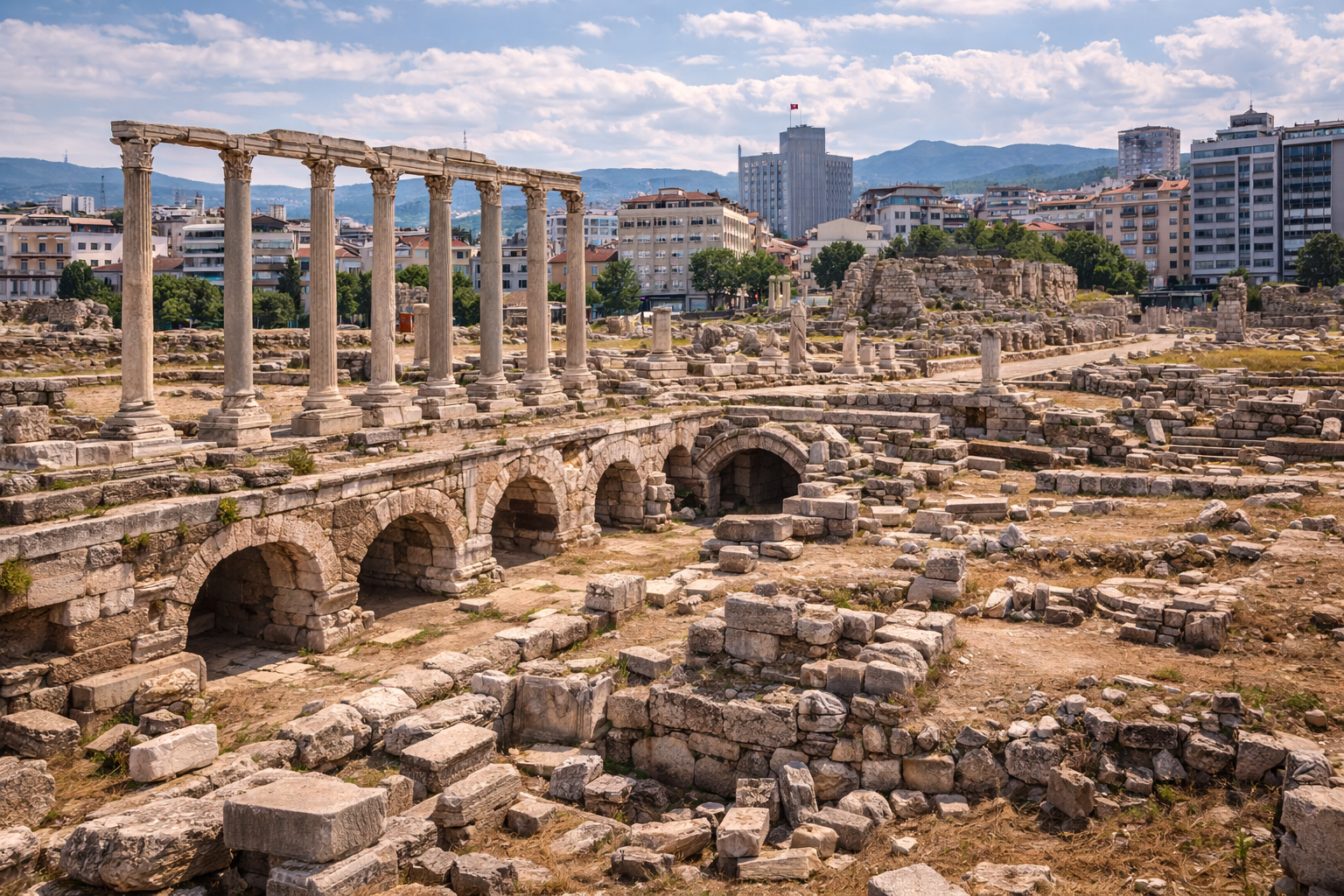
أبرز المعالم الأثرية
الأغورا
الأغورا (السوق العامة والمركز المدني) هي إحدى المناطق الأكثر تنقيبًا في كيمي. كشف عنها خلال الحفريات التي أجراها متحف إزمير للآثار منذ عام 1980، ويشمل مجمّع الأغورا:
- فضاءً مستطيلًا مفتوحًا للتجارة والتجمعات العامة
- الرواق (الأعمدة المسقّفة) على جوانب متعددة توفر الظل والمساحة التجارية
- مبانٍ إدارية على الأطراف
- شواهد على مراحل بناء متعددة تمتد عبر الحقبتين الهلنستية والرومانية
كانت الأغورا قلب الحياة المدنية في كيمي، المكانَ الذي يلتقي فيه المواطنون للنقاش السياسي والمعاملات التجارية والشعائر الدينية والتفاعل الاجتماعي.
المسرح
شُيّد المسرح على منحدر طبيعي يطل على البحر، مستفيدًا من تضاريس التل على النمط الإغريقي الكلاسيكي. من أبرز سماته:
- كافيا نصف دائرية (مقاعد الجمهور) منحوتة في المنحدر
- مبنى المسرح (سكيني) محفوظة أساساته
- مناظر تطلّ على خليج نمروت توفر خلفية أدائية بديعة
- شواهد على ترميمات وتوسعات تعود للحقبة الرومانية
يُعدّ توجيه المسرح نحو البحر من أبرز سماته المميّزة، إذ يتيح للجمهور مشهدًا بانوراميًا على الميناء وبحر إيجه وراءه.
معبد إيزيس
اكتُشف خلال حفريات أ. سالاك عام 1925، ومعبد إيزيس منشأةٌ صغيرة لكنها بالغة الأهمية، مكرّسةٌ للـإلهة المصرية إيزيس. يدل وجود معبد لإيزيس في كيمي على:
- الطابع العالمي لكيمي في الحقبة الرومانية
- الصلات التجارية البحرية بمصر وشرق البحر الأبيض المتوسط
- انتشار الأديان الغنوصية المصرية عبر المدن الساحلية
- التنوع الديني على ساحل أيوليس
كذلك صوّرت عملات كيمي من الحقبة الرومانية إيزيس وحورس، مما يؤكد أهمية هذه العبادة في الحياة الدينية للمدينة.
الشارع المعمّد
خدم الشارع المعمّد (الكاردو أو الشارع الرئيسي) شريانَ الحياة لمدينة الحقبة الرومانية. هذا الشارع المبطّن بالأعمدة من الجانبين:
- كان يربط الميناء بالأغورا والمدينة العليا
- وفّر ممرات مسقوفة للتجارة وحركة المشاة
- ضمّ واجهات محلات خلف الأعمدة
- يُجسّد المثال الروماني للتصميم العمراني الضخم
منشآت الميناء
كان ميناء كيمي محرّك ازدهارها. تشمل البقايا الظاهرة:
- أساسات موانع الأمواج القديمة مرئيةٌ تحت الماء وعلى طول الشاطئ
- جدران الرصيف لرسو السفن
- أساسات المستودعات لتخزين البضائع
- ترسبات الأمفورا التي تدل على حجم التجارة البحرية وتنوعها
يُعدّ امتلاء الميناء تدريجيًا بالطمي أحد الأسباب الرئيسية لتراجع المدينة في أواخر العصور القديمة.
منزل التاجر والصهريج
كشفت الحفريات عن منزل تاجر ضخم من الحقبة الرومانية مزوّد بصهريج خاص لتخزين المياه. يكشف هذا المبنى السكني عن ازدهار الطبقة التجارية في كيمي ويلقي الضوء على الحياة اليومية في المدينة الرومانية.
الأسوار والتحصينات
كانت المدينة محاطةً بـأسوار دفاعية يمكن تتبّع آثارها حول أجزاء من محيط المستوطنة. وقد ضمّت الأسوار أبراجًا في مواقع استراتيجية وبوابات تُتحكّم بالدخول إلى المدينة.
العملات والاقتصاد
تُعدّ عملات كيمي من أكثر عملات المدن الأيولية دراسةً وتحليلًا. أبرز خصائصها:
العملات المبكرة
كانت كيمي من أوائل المدن التي اعتمدت سك النقود، الذي اخترعته ليديا المجاورة في القرن السابع ق.م. سُكّت العملات الأولى من الإلكتروم (سبيكة طبيعية من الذهب والفضة).
أيقونوغرافيا العملات
تميّزت عملات كيمي بصور:
- الحصان (الرمز الأساسي للمدينة، ربما في إشارة إلى أسطورة التأسيس الأمازوني)
- شخصية أمازونية (مُعرَّفة بالمؤسِّسة الأسطورية ميرينا)
- إيزيس وحورس (على إصدارات الحقبة الرومانية، انعكاسًا للعبادة في معبد إيزيس)
- رموز نهرية (في إشارة إلى نهر هيلوس)
التيتراخما الفضية
التيتراخما الفضية الكبيرة لكيمي، المُنتَجة في الحقبة الهلنستية، من أجمل العملات في العالم الإغريقي القديم. تُظهر عادةً رأس أمازونية على الوجه ورأس حصان على الظهر.
الأهمية الاقتصادية
يشهد حجم عملات كيمي وتوزيعها على:
- المشاركة الفاعلة في شبكات التجارة المتوسطية
- دور المدينة بوصفها مركزًا اقتصاديًا إقليميًا رئيسيًا
- صلات تجارية تمتد من البحر الأسود إلى مصر
- الإنتاجية الزراعية للمنطقة المحيطة
الصلة بهيسيود
من أبرز ما تفخر به كيمي ثقافيًا ارتباطها بالشاعر الإغريقي هيسيود (نحو 700 ق.م)، أحد أقدم الشعراء وأكثرهم تأثيرًا في التراث الأدبي الغربي.
وفقًا لرواية هيسيود ذاتها في "الأعمال والأيام"، كان والده تاجرًا أبحر من كيمي عابرًا بحر إيجه ليستقر في أسكرا ببيوتيا (اليونان القارية). ومع أن هيسيود نفسه وُلد في بيوتيا، فإن أصول عائلته في كيمي تربط المدينة بأعرق جذور الثقافة الأدبية الإغريقية.
تُعدّ أعمال هيسيود — "الثيوغونيا" (نسب الآلهة) و"الأعمال والأيام" (قصيدة عملية في الزراعة والعدالة) — نصوصًا تأسيسية في الأدب الغربي. ويعكس انتماء عائلته إلى كيمي رقيَّ المدينة الثقافي ودورها في الشبكة الاستعمارية والفكرية اليونانية الأوسع.
وقد كان هذا الارتباط مصدر فخر لمواطني كيمي عبر العصور القديمة، ولا يزال الباحثون المعاصرون يدرسون العلاقة بين التقاليد الثقافية الأيولية والابتكارات الأدبية في شعر هيسيود.
الأعمال الأثرية
حفريات راينش (أواخر القرن التاسع عشر)
أُجريت أولى التحقيقات الأثرية في كيمي على يد راينش في نهاية القرن التاسع عشر. ركّز عمله على منطقة المقبرة وأسفر عن:
- تماثيل حجرية من الحقبة الأرخاية
- تجهيزات قبور وفّرت الإطار الزمني الأول للموقع
- شواهد على أنماط الاستيطان المبكر
حفريات سالاك (1925)
أجرى أ. سالاك من جامعة براغ حفريات أكثر شمولًا عام 1925، وكشف عن اكتشافات عدة بالغة الأهمية:
- معبد إيزيس
- رواق روماني (بورتيكوس)
- منشأة مُعرَّفة بـمنزل الفخّاري
- قطع أثرية متنوعة وشظايا معمارية
حفريات متحف إزمير للآثار (1980–حتى الآن)
منذ عام 1980، وسّعت الحفريات المنهجية التي يُشرف عليها متحف إزمير للآثار توسيعًا جوهريًا فهمَنا للمدينة. تشمل أبرز الاكتشافات:
- الأغورا من الحقبة الرومانية والمباني المحيطة بها
- المسرح ومراحل بنائه
- مجمّع الحمّامات (حمّام المياه الساخنة)
- منزل التاجر والصهريج
- منظومة قناة المياه
- الطريق المعمّد
- الأسوار والمنشآت الدفاعية
- شبكات مياه الصرف والخزانات وأنظمة الصرف الصحي
- بقايا أمفورا عديدة تكشف أنماط التجارة
- أطلال الميناء بما فيها بقايا موانع الأمواج تحت الماء
دراسات المقابر
نُشرت دراسات أكاديمية حول مقابر كيمي في مجلات من بينها Mediterranean Archaeology and Archaeometry (MAA) وCEDRUS. تشمل موضوعات البحث:
- الانتقال من الحرق إلى الدفن في ممارسات الدفن
- أنواع القبور والعادات الجنائزية
- دفن الأطفال في مقبرة الجنوب
- التطور الزمني لممارسات الدفن من الحقبة الأرخاية حتى الحقبة الرومانية
معلومات الزيارة
الموقع: بالقرب من علياغا، ولاية إزمير، على شواطئ خليج نمروت. يبعد الموقع الأثري نحو 45 كم شمال مركز إزمير.
كيفية الوصول:
- بالسيارة من إزمير: خذ طريق إزمير–چاناق قلعة السريع (O-3/E87) شمالًا إلى علياغا، ثم اتبع اللافتات نحو خليج نمروت / الموقع الأثري لكيمي (نحو 45 دقيقة)
- بالمواصلات العامة: حافلات منتظمة من إزمير إلى علياغا؛ مواصلات محلية من علياغا إلى الموقع
- إحداثيات GPS: نحو 38.77 شمالًا، 26.93 شرقًا
أفضل أوقات الزيارة:
- الربيع (مارس–مايو): طقس مثالي، منظر أخضر، درجات حرارة مريحة
- الخريف (سبتمبر–نوفمبر): أيام دافئة، ضوء ذهبي، زوار أقل
- الصيف: حارّ جدًا؛ يُنصح بالزيارة صباحًا باكرًا أو بعد الظهر
- الشتاء: معتدل بالمعايير التركية؛ مطر متقطع
مدة الزيارة:
- جولة سريعة: 1–1.5 ساعة
- زيارة عادية (الأغورا، المسرح، منطقة الميناء): 2–3 ساعات
- زيارة شاملة مع المقبرة والمشي الساحلي: 3–4 ساعات
ما يُنصح برؤيته (قائمة الأولويات):
- مجمّع الأغورا — المنطقة الأكثر تنقيبًا
- المسرح بمناظره البحرية
- بقايا الميناء على طول الشاطئ
- منطقة معبد إيزيس
- أقسام الشارع المعمّد
- آثار الأسوار
- مناطق المقابر (الشرقية والجنوبية)
نصائح للزوار:
- احضر ماءً وواقيًا من الشمس — الظل شحيح
- الموقع مسوّر جزئيًا؛ تحقّق من شروط الدخول قبل الزيارة
- بعض المناطق قرب الميناء قد تكون موحلة بعد المطر
- المحيط الصناعي مزعجٌ بصريًا لكنه لا يقلّل من الأهمية الأثرية
- ضوء الصباح أنسب لتصوير المسرح ومناظر الميناء
- اجمع الزيارة مع جولة في مدينة علياغا للوجبات والتموين
المواقع القريبة:
- ميرينا (مدينة أيولية أخرى، نحو 15 كم جنوبًا)
- برغاما / بيرغاما (نحو 50 كم شمال شرق)
- فوكايا / فوجا (نحو 40 كم جنوبًا)
- مركز مدينة إزمير ومتحف الأغورا (نحو 45 كم جنوبًا)
الأسئلة الشائعة
ماذا يعني اسم "كيمي"؟
الاشتقاق اللغوي محلّ جدل. يربطه بعض العلماء بكلمة إغريقية تعني "موجة" (kyma)، وهو ما يلائم مدينةً ساحلية. ويربطه آخرون بتسمية أناضولية قبل إغريقية. وقد سُمّيت المدينة أحيانًا "فريقونيس" في المصادر القديمة.
هل وُلد هيسيود في كيمي؟
لا. وُلد هيسيود في أسكرا ببيوتيا (اليونان القارية). غير أن والده هاجر من كيمي إلى بيوتيا قبل ولادة هيسيود. إذن كيمي هي الوطن الأصلي لعائلة هيسيود، لا مسقط رأسه.
هل يمكن رؤية الميناء تحت الماء؟
أجزاء من موانع الأمواج القديمة مرئية عند خط الماء وفي المياه الضحلة على طول الشاطئ. لا تحتاج إلى معدات خاصة لمشاهدة الكتل الكبيرة، لكن علم الآثار المائية وثّق بقايا أكثر اتساعًا تحت السطح.
لماذا يوجد معبد لإيزيس في مدينة إغريقية؟
في الحقبة الرومانية، انتشرت الأديان المصرية — ولا سيما عبادة إيزيس — في أرجاء العالم المتوسطي عبر طرق التجارة البحرية. كانت المدن الساحلية ككيمي محاور طبيعية لنقل هذه الأديان. أحضر البحارة والتجار والمهاجرون القادمون من مصر ممارساتهم الدينية التي تبنّتها السكان المحليون.
كيف تُقارَن كيمي ببرغاما القريبة؟
كانت برغاما عاصمةً ملكيةً تزخر بعمارة هلنستية ضخمة (المذبح الشهير، المكتبة، الأكروبوليس). أما كيمي فكانت مدينةً تجارية ساحلية اعتمدت أهميتها على التجارة البحرية لا على القوة السياسية. وتمثّل كلتاهما وجهين متكاملين للحياة الحضرية القديمة في المنطقة.
هل عملات كيمي ذات قيمة؟
عملات كيمي، ولا سيما التيتراخما الفضية من الحقبة الهلنستية، مرغوبٌ فيها عند هواة الجمع وتظهر باستمرار في مزادات العملات. وهي من أجمل عملات العالم الأيولي القديم فنيًا.
السجل النميزماتي التفصيلي
يُعدّ إنتاج عملات كيمي من أكثر ما دُرس وحُلّل في أي مدينة أيولية. وتكشف دراسات القوالب وتحليل التوزيع عن المدى الاقتصادي للمدينة وطموحها الفني.
التيتراخما الفضية (165–140 ق.م)
| المعامل | التفاصيل |
|---|---|
| الفئة | تيتراخما فضية AR |
| القطر | 33 ملم |
| الوزن | 16.67 غ (معيار أتيكي مخفّف قليلًا، نحو 16.7 غ) |
| الوجه | رأس الأمازونية كيمي مرتديةً الطاينيا |
| الظهر | حصانٌ واقفٌ يمينًا؛ كأسٌ بيد واحدة (سكيفوس) في الأسفل؛ اسم المسؤول النقدي في الحقل |
| دراسة القوالب | رصدت دراسة أوكلي على 540 قطعة موجودة 12 مسؤولًا نقديًا و79 قالبًا للوجه |
| فترة الضرب | بين 165 و140 ق.م، في إصدارات متعاقبة |
حجم الإنتاج — 79 قالبًا للوجه لفئة واحدة — يضع كيمي في مصاف أكثر مراكز سك العملة إنتاجيةً على الساحل الأيولي الهلنستي. وقد تداولت هذه التيتراخمات من البحر الأسود إلى مصر، مما يشهد على اندماج كيمي في شبكات التجارة العابرة للبحر الأبيض المتوسط.
إصدارات الإلكتروم والإصدارات الإسكندرية المبكرة
قبل سلسلة التيتراخما، ضربت كيمي عملات إلكتروم (سبيكة طبيعية من الذهب والفضة) في القرنين السابع والسادس ق.م، على غرار النموذج الليدي الرائد. وفي مطلع الحقبة الهلنستية (نحو 215–200 ق.م)، أنتجت المدينة تيتراخما فضية على النمط الإسكندري، مما ربط إنتاجها النقدي بالمنظومة الاقتصادية الهلنستية الأشمل التي رسّخها الإسكندر الأكبر.
أيقونوغرافيا العملات في الحقبة الرومانية
قدّمت البرونزيات الرومانية الإقليمية من كيمي صورة إيزيس وحورس على الظهر، انعكاسًا للعبادة المصرية التي أثبتها أثريًا معبد إيزيس الذي اكتشفه أ. سالاك عام 1925. ويُثبت بقاء رمز الحصان على العملات من الحقبة الأرخاية حتى الحقبة الرومانية أكثر من 700 عام من الهوية المدنية المتواصلة.
دراسات المقابر: ممارسات الدفن وأنواع القبور
أسفرت الحفريات الأثرية في مقابر كيمي عن سجل مفصّل للعادات الجنائزية يمتد على مدى يقارب الألف عام.
مقبرة الشرق
| المعامل | التفاصيل |
|---|---|
| إجمالي القبور المحفورة | 343 (في ثلاث حملات حفر) |
| النطاق الزمني | من القرن الثامن ق.م إلى القرن الأول الميلادي |
| أنواع القبور المرصودة | 9 أنواع مختلفة |
| التحوّل الرئيسي | تحوّل تدريجي من الحرق (السائد في الحقبة الأرخاية) إلى الدفن (السائد في الحقبة الرومانية) |
| النشر | Mediterranean Archaeology and Archaeometry (MAA)، 2019 |
يعكس الانتقال من الحرق إلى الدفن في كيمي تحوّلات ثقافية أشمل في العالم الإغريقي، لكنه يتبع تسلسلًا زمنيًا محليًا يوفّر مجموعة بيانات خاصة بالمنطقة. وتعكس الأنواع التسعة للقبور — من حفر بسيطة إلى مقابر حجرية مبنية — تفاوت المكانة الاجتماعية والعادات الخاصة بكل حقبة.
مقبرة الجنوب (باتي ليمان)
زوّد قبر طفل حفرته متاحف إزمير عام 2011 في قطعة باتي ليمان 1205 بيانات إضافية حول وفيات الرضع وممارسات الدفن في كيمي. نُشرت المعثورات في CEDRUS: The Journal of Mediterranean Civilisations Studies، مع توثيق محتويات القبر والتحليل الهيكلي.
شاهد قبر هلنستي
جُدِّد وأُعيد نشر شاهد جنائزي هلنستي ضخم من كيمي في Revue Archeologique (2013)، مما أتاح شواهد جديدة على الفن الجنائزي الأثري في منطقة أيوليس خلال القرنين الثالث والثاني ق.م.
تسلسل الحفريات والمسوحات الجيوفيزيائية
| العام / الحقبة | المدير / الفريق | التركيز والنتائج |
|---|---|---|
| أواخر القرن التاسع عشر | راينش | حفريات المقبرة؛ تماثيل حجرية من الحقبة الأرخاية؛ الإطار الزمني الأول |
| 1925 | أ. سالاك (جامعة براغ / البعثة البوهيمية) | معبد إيزيس؛ البورتيكوس الروماني؛ منزل الفخّاري؛ شظايا معمارية |
| 1955 | إ. أكورغال | خزفيات أسلوب الاستشراق على التل الجنوبي |
| 1979–1984 | متحف إزمير للآثار | الأغورا، المسرح، الميناء، مجمّع الحمّامات، قناة المياه، الطريق المعمّد، الأسوار، شبكات الصرف |
| 2011 | متاحف إزمير | قبر طفل في مقبرة الجنوب (باتي ليمان) |
| السنوات الأخيرة | فرق المسح الجيوفيزيائي | مسوحات مغناطيسية أرضية كشفت منشآت لم تُحفر بعد تحت السطح |
تكتسب حملات المسح المغناطيسي الأرضي أهمية خاصة: إذ كشفت عن أساسات مبانٍ إضافية تحت سطح التربة الحديثة لم تُحفر قط، مما يوحي بأن الأطلال المرئية لا تمثّل إلا جزءًا من النسيج العمراني القديم. وتوجّه هذه النتائج تخطيط الحفريات المستقبلية وصون الموقع.
إنتاج الأمفورا والتجارة
توثّق الشواهد الأثرية الخاصة بـالأمفورا من نمط دريسيل 24 سيميليس، المُنتَجة في ورش قرب كيمي، صناعةً زيتٍ زيتون متينةً خلال الحقبة الرومانية المبكرة. ويُظهر تحليل توزيع هذه الأمفورا شحنات وصلت إلى مواقع وسط بحر إيجه من بينها خيوس وإريثراي، مما يؤكد دور كيمي بوصفها مركزًا إقليميًا لتصدير المنتجات الزراعية.
المصادر وقراءات إضافية
- Wikipedia — Cyme (Aeolis)
- Visit Izmir — Kyme Antique City
- Aeternitas Numismatics — Kyme: The Ancient Aeolian Harbour
- CoinWeek — Ancient Greek Coins of Aiolis
- Mediterranean Archaeology and Archaeometry — Eastern Necropolis of Cyme: Transition from Cremation to Inhumation
- CEDRUS Journal — A Child Grave from the Southern Necropolis of Cyme
- Topostext — Kyme (Aiolis)
- Sulla Coins — Exploring the AR Tetradrachm of Kyme