快速概述: 塞尔吉 是古代 皮西迪亚 最强大、人口最稠密的城市之一,坐落于 托罗斯山脉 腹地海拔约 1,250 米 之处。如今它位于 安塔利亚马纳夫加特 的 阿尔特恩卡亚(泽尔克) 村附近的 库普吕峡谷国家公园 内,以其保存极为完好的 罗马剧场(容量 10,000)、古老的 欧律墨冬桥(奥卢克桥)、宙斯和阿尔忒弥斯神庙 以及 体育场 而闻名。尽管地处偏远山区,塞尔吉曾拥有一支 20,000 人的军队,并因出口 木材和苏合香树脂 而富裕起来。该遗址从未经过系统性发掘,现代村庄中许多房屋是用从古代废墟中拾取的带铭文或装饰的石材建造的——这使塞尔吉成为一座古代与现代共存的活生生的层叠史册。
目录
为什么塞尔吉重要
塞尔吉在古代世界中因若干原因而占据着独特地位:
-
繁荣非凡的山城堡垒。 大多数主要的古代城市都建在海岸或肥沃的平原上,而塞尔吉却在安纳托利亚最崎岖的地形之一中、海拔逾 1,000 米的高度上欣欣向荣。古代地理学家斯特拉博记载,这座城市能够召集 20,000 名士兵,使其成为最强大的皮西迪亚聚落之一——这对于一座远离海岸和主要贸易路线的城市来说,是非凡的军事能力。
-
土耳其保存最完好的罗马剧场之一。 塞尔吉剧场建于公元 2 世纪,其观众席(cavea)保留了几乎完整的状态。其估计的座位容量约为 10,000,是该地区现存最优秀的罗马剧场之一。与附近的佩尔吉和锡德等古城不同,塞尔吉剧场从未经过重建,让访客得以一睹古代剧场在现代干预之前的真实面貌。
-
欧律墨冬桥——罗马工程的奇迹。 塞尔吉附近横跨欧律墨冬河(今库普吕河)的古代石桥,是罗马在山地地形中桥梁建造的杰出范例。当地称之为奥卢克桥(沟槽桥),这座建于公元 2 世纪的建筑物长 14 米、宽 3.5 米,拥有一座跨度约 7 米的单一尖拱——至今仍然屹立并可通行,是土耳其保存最完好的罗马桥梁之一。
-
极致美丽的自然环境。 塞尔吉位于土耳其最具风景的保护区之一——库普吕峡谷国家公园内,将考古意义与深邃峡谷、松林、湍急河流以及被称为"亚当卡亚拉尔"(人岩)的奇特砾岩岩柱所构成的壮丽自然景观结合在一起。
-
与亚历山大大帝的外交关系。 公元前 333 年亚历山大穿越皮西迪亚时,塞尔吉是少数派遣使节而非进行抵抗的城市之一,从而获得了友谊与自治权——这是这座城市政治成熟与务实生存本能的明证。
-
未经发掘的宝藏。 塞尔吉从未成为全面系统性发掘的对象。其城市肌理的大部分仍然埋藏地下,现代的阿尔特恩卡亚村就坐落在古城部分区域之上。未来的发掘可能揭示有关皮西迪亚城市规划、贸易网络与山地聚落策略的重要新信息。
地理与环境
塞尔吉位于托罗斯山脉的南坡,海拔约 1,250 米,欧律墨冬河(库普吕河)在此切穿戏剧性的峡谷地形,奔向地中海岸。古城俯瞰壮丽的 库普吕峡谷——土耳其最深的河流峡谷之一,悬崖落差超过 400 米直入河中。
现代的 阿尔特恩卡亚 村(原名为 泽尔克,通过千年语言演变保留了古代名称)占据了古代遗址的部分区域。塞尔吉位于库普吕峡谷游客中心以北约 12 公里 处,通过一条蜿蜒的山路抵达,这条山路本身就提供了令人叹为观止的峡谷、河流与周围山脉的景观。
塞尔吉周围的地形以当地称为"亚当卡亚拉尔"(人岩)的不寻常 砾岩岩柱 为特征——这些是由胶结砾石风化而成的柱体,赋予这片土地以超现实的雕塑感。这些地貌是数百万年的侵蚀作用作用于古代河流沉积物所形成的,造就了天然的柱体与塔楼,古代居民可能曾以迷信的敬畏之心看待它们。
该地区被 地中海松(特别是卡拉布里亚松)、雪松(包括本地的托罗斯雪松)和 马基灌丛 植被茂密覆盖。由山泉与融雪汇成的欧律墨冬河,既为塞尔吉提供了天然防御——峡谷除了在架桥渡口外几乎无法通行——也提供了通往海岸阿斯彭多斯的下游运输通道,用于其木材出口。
这一海拔的气候明显比下方的沿海平原凉爽:夏季温暖但可承受(通常为 25–30 摄氏度,而沿海为 35–40+ 摄氏度),冬季则带来降雪和偶尔的道路封闭。最佳参观季节为 5 月到 10 月,6 月和 9 月提供了舒适气温与可通行道路的理想组合。
历史年表
起源与传说源头
据斯特拉博所述,塞尔吉由 斯巴达人 创建,但他添加了一条隐晦的注脚:"此前它由卡尔卡斯创建"——这位特洛伊战争中的传奇希腊先知最终死于伊奥尼亚的克拉罗斯。这一双重起源传说既暗示了希腊殖民影响,也暗示了该地区更早期的安纳托利亚本土聚落。如果斯巴达的联系属实,可能解释了塞尔吉非凡的军事声誉及其顽强的独立性。
这座城市的名称可能源自当地的安纳托利亚语言,早于希腊殖民。考古证据表明该地区至少自 公元前 7 世纪 起即有人居住,并且该地区属于更广泛的皮西迪亚文化区——一个以战士传统、语言独特性及抵御外来控制而著称的高地文化。
古典与希腊化时期(公元前 5—1 世纪)
塞尔吉发展成为皮西迪亚最强大的城市之一,以其坚定的独立性和强大的军事能力闻名。重要事件包括:
- 公元前 5 世纪: 塞尔吉开始铸造自己的银币与铜币——这对于一座皮西迪亚城市来说异常早,表明其经济发展显著且具有政治自信。钱币图案描绘了摔跤者(反映皮西迪亚精英所采纳的希腊体育文化)、三足旋转符号(triskeles)以及戈耳工头像。
- 公元前 333 年: 当 亚历山大大帝 从戈尔迪翁向地中海岸进军、穿越皮西迪亚时,大多数城市都进行了激烈抵抗。塞尔吉选择了外交途径,派遣使节献礼并提议结盟。亚历山大接受了,城市得以保持自治——这一务实决定使其免遭如特尔梅索斯和萨加拉索斯所经历的围攻与毁灭。
- 公元前 218 年: 塞尔吉被 阿凯欧斯(一位塞琉古叛将,已在安纳托利亚西部自立为独立统治者)围攻。历史学家 波利比乌斯 在其《历史》第五卷中提供了对该围攻的极其详细的记述,指出塞尔吉当时的人口约为 20,000,城市在最终谈判和解之前进行了激烈防御。波利比乌斯描述这座城市的山地防御几乎坚不可摧,迫使阿凯欧斯诉诸诡计而非正面强攻。
- 公元前 2—1 世纪: 随着周边地区日益受到罗马影响,塞尔吉仍维持其独立并继续铸币。该城市的山地堡垒地位使任何外部势力都难以施加直接控制。
罗马时期(公元前 1 世纪——公元 4 世纪)
在罗马统治下,塞尔吉保留了比大多数皮西迪亚城市更大的自治程度,这反映在它直到 公元 3 世纪 仍保有铸造自己钱币的权利。该城市在罗马帝国时期经历了重要的建造活动:
- 公元 1—2 世纪: 建造了大剧场(容量 10,000)、体育场以及供奉宙斯与阿尔忒弥斯的大型神庙建筑群。这些纪念性建筑表明,塞尔吉即使在海拔 1,250 米也拥有足够的财富和人口来投资于大规模公共建筑。
- 公元 2 世纪: 建造了 欧律墨冬桥(奥卢克桥),改善了山城与潘菲利亚沿海平原之间的道路联系。该桥的建造工艺——经雕琢的石块与尖拱——以及坚固的石作工艺,确认其年代为公元 2 世纪,恰与最繁荣的时期相吻合。
- 哈德良统治时期(公元 117—138 年): 钱币学证据表明,塞尔吉在哈德良时期仍是繁荣的城市中心,发行了带有皇帝肖像的钱币。
- 公元 3 世纪: 与许多安纳托利亚城市一样,塞尔吉开始在更广泛的经济动荡、政治危机以及来自外部威胁的压力增大下走向衰落。
晚期古代与拜占庭时期(公元 4—7 世纪)
公元 4 世纪末的一次严重地震 摧毁了城市的引水渠,切断了维系这一海拔城市生活的供水。引水渠从未被修复——这一决定(或失败)封死了塞尔吉的命运。没有可靠的供水,人口无法维持几个世纪以来塑造这座城市的城市组织水平。
尽管发生了这一灾难性事件,该城在拜占庭时期仍保留了一定的重要性:
- 已识别出 五座教堂的遗迹,表明一个基督教社区在地震之后的数个世纪中仍持续存在,适应着减少的处境
- 塞尔吉在拜占庭时代曾担任 主教区 一段时间,表明它保留了足够的人口和行政重要性以获得教会的承认
- 至少有一座神庙(可能是宙斯神庙)被 改建为教堂,这是基督教化罗马帝国中的普遍做法
- 该城在随后的几个世纪中逐渐被遗弃,人口迁往更易抵达的低地聚落,最终在废墟之中只留下泽尔克村(后来的阿尔特恩卡亚)
主要纪念物与建筑
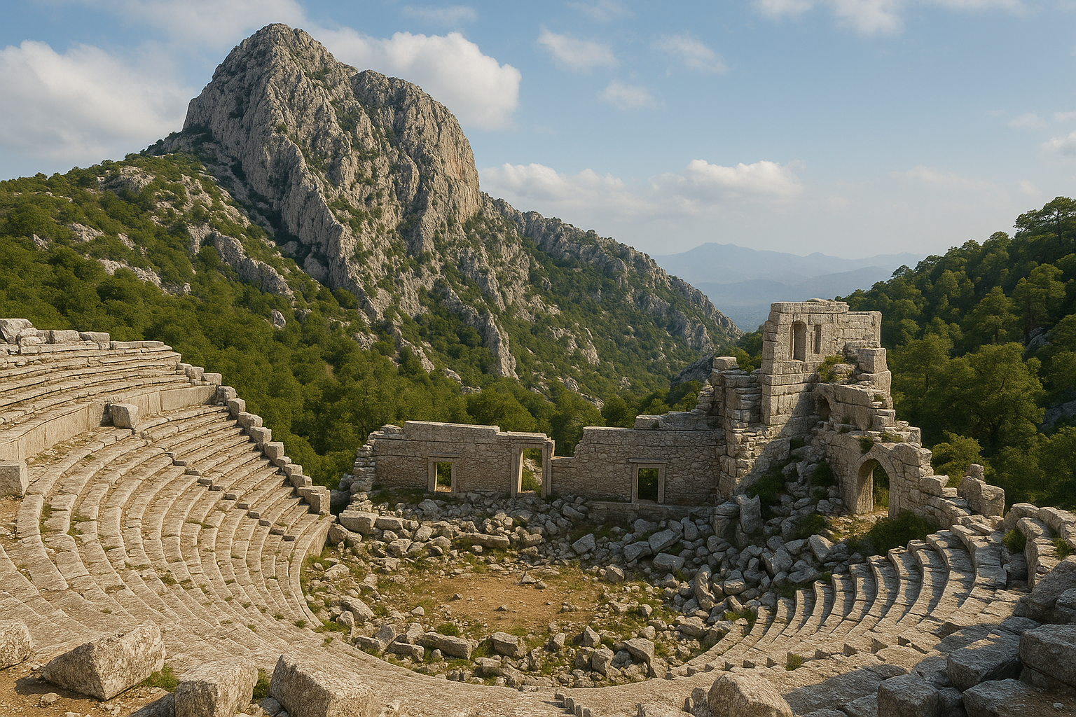
剧场
塞尔吉剧场是该城市最瞩目的纪念物,也是土耳其南部保存最完好的罗马剧场之一。关键特征:
- 年代: 按希腊化-罗马式平面建造于 公元 2 世纪
- 容量: 约 10,000 名观众——对一座山城而言规模可观,表明要么人口非常庞大,要么剧场承担着吸引周边聚落观众的区域性功能
- 结构: 观众席(cavea)建在天然山坡上,利用倾斜地形减少了对人工基础结构的需求。座位排基本完整,从天然基岩中开凿并构筑于其上
- 舞台建筑(skene): 舞台建筑已倒塌,但基础墙体和散落的建筑构件(柱鼓、檐部块、装饰线脚)仍可见,使得在想象中重建建筑的原始形态成为可能
- 景观: 剧场俯瞰周围山脉、欧律墨冬峡谷以及亚当卡亚拉尔岩石地貌的壮丽全景——是古代世界最具戏剧性的剧场环境之一,在风景壮丽方面可与西西里岛的陶尔米纳剧场相媲美
- 声学: 剧场的声学效果至今依然出色;访客可以站在乐池地面上发言,听到自己的声音从上层座席清晰反射回来——这是对罗马声学工程精度的明证
体育场
位于剧场下方偏南处,体育场曾举办体育比赛和节庆活动。其细长的 U 形形状仍可在地形中追溯,长约 230 米,但保存程度不如剧场。体育场的存在突显了塞尔吉对希腊体育文化的参与,这也反映在该城早期钱币上描绘的摔跤者形象中。体育场在皮西迪亚城市中相对罕见,使塞尔吉的例子尤为重要。
宙斯神庙
在卫城地区,已识别出一座供奉 宙斯 的神庙遗迹。宙斯是塞尔吉的主神,神庙遗迹以及罗马时期城市钱币上宙斯图像的突出地位均为证据。神庙在卫城上的高地位置反映了宙斯与山顶和天象的典型联系——这种联系在一座几乎建在云端的城市中产生了强烈共鸣。
阿尔忒弥斯神庙
第二座主要神庙供奉 阿尔忒弥斯——狩猎与野性自然的女神,对于一座被野生动物茂密森林环绕的山城而言,她是合适的守护神。神庙遗迹包括柱体碎片、建筑石块和带铭文的石头。阿尔忒弥斯崇拜在皮西迪亚和潘菲利亚腹地广为流传,将塞尔吉与该地区更广泛的宗教网络连结在一起。
阿戈拉
作为城市的商业与公民中心,阿戈拉占据卫城附近一块相对平坦的区域。一条铺砌道路通向它,周围柱廊(带列柱的走廊)和商铺的痕迹可以辨识。这里是市民聚集进行商业、政治集会、法律程序和社交活动的地方——塞尔吉公民生活的跳动心脏。
音乐厅(奥德翁)
在阿戈拉附近,一座奥德翁(小型有顶剧场)用于音乐表演、讲座和较小型的公民集会。它与大剧场互为补充,大剧场则用于主要的戏剧表演与公共演出。奥德翁较小的有顶空间为口语类活动提供了更好的声学效果,也为山地天气提供了庇护。
城墙与防御工事
塞尔吉受到一圈防御性城墙的保护,这些城墙利用了天然地形。沿古城周边可见以大型石块建造的部分城墙。多面的天然峡谷和悬崖屏障意味着只需要有限的城墙段就能构建一个完全可防御的周界——这是皮西迪亚人以其典型效率所利用的地理优势。
欧律墨冬桥(奥卢克桥)
位于城市中心以南约 3 公里 处,这座罗马时期的桥梁以单一尖拱跨越欧律墨冬河:
- 尺寸: 长 14 米、宽 3.5 米,路面宽 2.5 米,拱的净跨约 7 米
- 建造: 经雕琢的石块加尖拱设计,展现了适应山地河流力量的精湛罗马工程
- 当代名称: 奥卢克桥(沟槽桥),指其顶部沿水道延伸的水渠,可能是城市供水系统的一部分
- 现状: 至今仍然屹立并可步行通过,使其成为土耳其保存最完好的罗马桥梁之一,是建造近 1,900 年后罗马工程耐久性的明证
- 功能: 该桥便利了塞尔吉与潘菲利亚沿海城市(特别是阿斯彭多斯)之间的往来,将山区经济连接到地中海贸易网络
引水渠与蓄水池
城市的供水依赖于将山泉之水引来的引水渠系统,可能由引导的融雪水和雨水补充。在城市内多处可见在岩石上凿出的古代蓄水池,其中一些相当大。公元 4 世纪末的灾难性地震摧毁了这些引水渠,未能修复是城市最终被遗弃的主要原因——这清楚地表明山地城市对工程化供水基础设施的依赖程度。
经济与贸易
塞尔吉的繁荣对如此偏远的山地位置而言非比寻常,其建立在几大经济支柱之上:
木材
塞尔吉周围茂密的 地中海松和托罗斯雪松森林 提供了丰富的木材,这是该城市的主要出口商品。原木顺欧律墨冬河漂流至沿海平原的 阿斯彭多斯,然后从那里运往东地中海各地,包括运至 埃及——那里因木材匮乏而对此有很高需求,主要用于造船。这种基于河流的木材贸易将偏远的山城连接到国际商业,并产生了可观的收入。
苏合香树脂
苏合香树(Liquidambar orientalis)原产于塞尔吉周围潮湿山谷与河岸,产生一种芳香的香脂树脂,在古代世界极受重视。斯特拉博特别提到此产品是塞尔吉财富的主要来源。该树脂用作:
- 宗教仪式与日常生活中的 香水与熏香
- 治疗伤口、呼吸道疾病和皮肤病的 药物
- 食物与葡萄酒中的 调味料 苏合香贸易将塞尔吉连接到从罗马到亚历山大再到安提阿等地中海各地的奢侈品市场。
葡萄酒与橄榄油
尽管海拔较高,周围的山坡与较低的山谷仍支持葡萄栽培与橄榄种植。葡萄酒和橄榄油补充了该城的农业经济,并可能通过与木材相同的下游路线进行贸易。
牲畜
塞尔吉周围的山地牧场支持了大量绵羊和山羊群,提供羊毛、乳制品和肉类。畜牧业是皮西迪亚高地经济的支柱,可能对塞尔吉的自给自足做出了重大贡献。
钱币
塞尔吉从至少 公元前 5 世纪 到 公元 3 世纪 铸造自己的钱币,这对一座皮西迪亚城市而言是异常悠久的铸币历史,是经济活力持续与政治自治的明确指标。这些钱币为该城市的文化取向与经济生活提供了宝贵证据:
早期钱币(公元前 5—4 世纪)的特征:
- 摔跤者 —— 两名裸体摔跤者扭打在一起,反映了皮西迪亚精英对希腊体育文化的采纳,可能与当地节庆比赛有关
- 三足旋转符号(triskeles) —— 一种三足旋转符号,也出现在其他皮西迪亚和潘菲利亚城市的钱币上
- 戈耳工头像 —— 在希腊世界各地常见的辟邪(驱邪)图案
- 雄鹿和野猪 —— 与托罗斯森林中狩猎相关的动物
后期罗马时期钱币(公元 1—3 世纪)描绘了:
- 宙斯 坐姿或站姿,确认其作为该城主神的地位
- 带有狩猎属性的 阿尔忒弥斯
- 执行其功绩的 赫拉克勒斯
- 在位罗马皇帝的 皇帝肖像,展示了塞尔吉融入帝国体系的同时保留了地方铸币权
考古工作
自 19 世纪 起,塞尔吉就吸引了学术界的关注,但它从未成为全面系统性发掘的对象——使其成为土耳其最重要的未经发掘的古代城市之一:
- 1842 年: 欧洲旅行者首次记录了这些废墟,注意到令人印象深刻的剧场和屹立的欧律墨冬桥。
- 1886 年: 波兰伯爵、历史学家和旅行家 卡罗尔·兰科罗恩斯基(Karol Lanckoronski) 在其对潘菲利亚和皮西迪亚的广泛调查期间访问了塞尔吉。他绘制了该古城的首份详细平面图,识别了主要建筑结构并记录了它们的状况。他的纪念性出版物《潘菲利亚和皮西迪亚的城市》(Stadte Pamphyliens und Pisidiens,1890—1892 年)至今仍是基础参考著作。
- 19 世纪末——20 世纪: 各位欧洲学者访问并描述了这些废墟,对识别和记录主要建筑做出了贡献。其中包括帮助在学术文献中确立塞尔吉重要性的考古学家、建筑师和钱币学家。
- 现代时期: 土耳其当局开展了保护工作,特别是对剧场和欧律墨冬桥进行了石作稳固和植被清理。该遗址在库普吕峡谷国家公园的范围内受到保护。
- 村庄考古: 现代阿尔特恩卡亚村中许多房屋是用来自古城的 带铭文、雕刻或装饰的石材 建造的,构成了一个非正式的露天建筑构件博物馆。柱鼓被用作花园围墙,带铭文的石块被用作门槛,装饰性檐口被用作搁板支撑——这是对古代材料务实但在考古上令人痛苦的再利用。
缺乏系统性发掘意味着塞尔吉的大部分城市肌理仍埋藏于地表之下和现代村庄之下。未来的考古发掘可能会就皮西迪亚城市规划、家庭建筑、水利管理以及高地社区融入地中海贸易网络等方面提供重要的新信息。
参观信息
如何抵达
从 安塔利亚(约 90 公里):沿 D-400 公路向东行驶,朝马纳夫加特/锡德方向。在库普吕峡谷路口(贝莱克/塞里克附近)向北转。沿峡谷路行驶约 45 公里至库普吕峡谷游客区,穿过欧律墨冬河上的古代和现代桥梁,然后继续沿蜿蜒山路向北行驶约 12 公里抵达阿尔特恩卡亚(泽尔克)村和古城。
从 锡德/马纳夫加特(约 70 公里):沿向北的道路前往塔沙吉尔,然后继续前往库普吕峡谷和塞尔吉。
从峡谷底部到阿尔特恩卡亚的最后 12 公里路段是狭窄、蜿蜒的山路。该路已铺装但需谨慎驾驶,尤其是在盲弯处以及遇到迎面车辆时。这段路提供了壮丽的景色,但需要全神贯注。仅此一段就需预留至少 45 分钟。
最佳参观时间
- 5 月—6 月: 理想的天气,野花覆盖草甸,绿意盎然的景观,融雪后河水充盈。雪顶山峰与春花的对比令人难忘。
- 9 月—10 月: 舒适的气温,金色的秋光衬托石质遗迹,清澈的山间空气。
- 7 月—8 月: 在此海拔高度温暖但可承受(25–30 摄氏度,而沿海为 35–40+ 摄氏度);下方峡谷的漂流旺季吸引人群到达较低峡谷地区,但很少有人到达塞尔吉本身。
- 11 月—4 月: 12 月至 3 月可能降雪;冬季山路可能无法通行。在尝试驾车前请向当地来源核实情况。
时长
为考古遗址本身规划 2 至 4 小时,加上旅行时间。结合参观库普吕峡谷和欧律墨冬桥,可以构成一次结合考古、自然与冒险的充实全日游。
设施
阿尔特恩卡亚村有几家小型家庭经营的餐馆(lokantas),提供传统的土耳其山地美食——欧律墨冬河的烤鳟鱼、山羊奶酪、新鲜面包、村庄沙拉以及浓茶。村中提供基础住宿(pansiyons),适合希望过夜的游客。考古遗址没有正式的售票处、游客中心或解说标识。结实的步行鞋是必不可少的,因为某些地段地形多岩石且陡峭。
与库普吕峡谷结合参观
塞尔吉最好作为更广泛的库普吕峡谷行程的一部分进行参观。峡谷地区提供:
- 在库普吕河(欧律墨冬河)上的 白水漂流 —— 土耳其最受欢迎的漂流目的地之一,激流难度从 II 级到 IV 级
- 奥卢克桥(奥尔班桥)—— 罗马欧律墨冬桥,可步行抵达
- 国家公园内的 徒步路线,包括长途圣保罗之路的部分路段
- 在清澈、冰凉的山间河流中 游泳
- 适合冒险者的侧峡谷 峡谷探险
常见问题
抵达塞尔吉有多困难?
铺装的山路对普通汽车可通行,但需要在狭窄、蜿蜒、护栏有限以及偶有盲弯的路段上自信驾驶。旅行团有时会使用小型巴士。从峡谷底部到阿尔特恩卡亚的旅程大约需要 45 分钟,这本身就是体验的一部分,沿途有壮观的峡谷与山景。不要在恶劣天气或天黑后尝试。
塞尔吉适合带孩子的家庭吗?
适合,但需严格注意。剧场区域有数米高、无护栏的陡降。地形不平、多岩石,并散布着古代墙基与蓄水池开口。儿童应受到严密监护,尤其是在剧场座席层级、悬崖边缘和无标识的蓄水池附近。话虽如此,喜欢徒步和户外冒险的孩子会发现塞尔吉引人入胜。
塞尔吉与亚历山大大帝有什么联系?
公元前 333 年亚历山大大帝在皮西迪亚作战时,大多数城市进行了抵抗(特尔梅索斯对抗了他;萨加拉索斯进行了战斗并被强攻拿下)。塞尔吉选择了外交途径,派遣使节献礼并提议结盟。亚历山大接受了,城市保留了自治并避免了毁灭——这是展现政治成熟的务实决定。
我可以在一天内同时参观塞尔吉和库普吕峡谷吗?
可以,这是最受欢迎的方式。从安塔利亚或锡德出发的典型一日游包括欧律墨冬桥(奥卢克桥)、漂流活动或峡谷漫步、在河畔餐厅享用新鲜鳟鱼午餐,然后下午驱车前往塞尔吉参观考古遗址。早出发(8:00 AM 之前)以充分利用一天时间。
塞尔吉发生了什么?它为什么被遗弃?
关键的转折点是公元 4 世纪末的一场毁灭性地震,摧毁了城市的引水渠。在这一海拔高度没有可靠的供水,人口无法维持城市基础设施。该城在随后的几个世纪中走向衰落,居民逐步迁往更易抵达的低地聚落。泽尔克村(今阿尔特恩卡亚)作为废墟之中的一个小型乡村社区延续了下来。
是否有导游服务?
安塔利亚、锡德和马纳夫加特的一些旅行运营商提供塞尔吉和库普吕峡谷地区的一日游,通常与漂流结合。租一辆车并具备基本的导航能力(建议使用 GPS)即可轻松独立参观。现场没有向导,因此为了获得最大的欣赏,请在参观前研究该遗址。
圣保罗之路是什么?
圣保罗之路 是一条 500 公里的长途徒步路线,从佩尔吉(安塔利亚附近)到亚尔瓦奇(皮西迪亚的安提阿),大致沿着使徒保罗第一次传教旅程所走的路线。这条小径穿过库普吕峡谷并靠近塞尔吉,使古城成为长途徒步者的天然中转站。
建筑测量与关键数据
| 特征 | 测量 / 详情 |
|---|---|
| 剧场观众席直径 | 104 米 |
| 下层观众席(ima cavea) | 30 排座位,分为 11 个楔形区 |
| 上层观众席(summa cavea) | 15 排座位,分为 22 个楔形区 |
| 总座位排数 | 45(由一条横通道分隔) |
| 剧场估计容量 | 9,300—11,600 名观众 |
| 观众席朝向 | 南偏南东 |
| 体育场长度 | 约 230 米 |
| 欧律墨冬桥长度 | 14 米 |
| 欧律墨冬桥宽度 | 3.5 米(路面 2.5 米) |
| 欧律墨冬桥拱跨 | 约 7 米 |
| 欧律墨冬桥拱石厚度 | 60 厘米(不用砂浆铺设) |
| 城市海拔 | 海拔约 1,250 米 |
| 军队规模(波利比乌斯,公元前 218 年) | 20,000 名士兵 |
钱币学证据
塞尔吉的钱币在皮西迪亚地区是最重要的钱币之一,通过呈现为 "Stlegiys" 的传说提供了关于皮西迪亚语言的罕见直接证据——这是该城的本地名称。这些钱币与邻近阿斯彭多斯的银斯塔特币非常相似,反映了沿欧律墨冬走廊的共同文化影响。
钱币面值与重量
| 面值 | 时期 | 重量 | 直径 | 正面 | 背面 |
|---|---|---|---|---|---|
| 银斯塔特 | 约公元前 400—325 年 | 10.87—10.88 克 | 22—24 毫米 | 两名摔跤者扭打 | 投石手,三足旋转符号 |
| 银斯塔特 | 约公元前 325—250 年 | 9.58—10.64 克 | 21—23 毫米 | 两名摔跤者 | 右向投石手,皮西迪亚语铭文 |
| 奥波尔 / 三半奥波尔 | 公元前 5—4 世纪 | 0.65 克 | 9 毫米 | 戈耳工头像胸像 | 雄鹿或阿尔忒弥斯头像 |
| 半奥波尔 | 公元前 5—4 世纪 | 0.27 克 | 6 毫米 | 戈耳工头像 | 距骨或三足旋转符号 |
| 青铜(罗马时期) | 公元 2—3 世纪 | 4—12 克 | 15—28 毫米 | 皇帝肖像 | 坐姿宙斯、阿尔忒弥斯、赫拉克勒斯 |
斯塔特币重量从早期系列到后期系列的下降(约从 10.88 克到 9.58 克)反映了希腊化时期更广泛的货币趋势,皮西迪亚城市根据贸易网络的变化以及阿提卡重量制度的影响逐步调整其标准。
钱币上的皮西迪亚语言
塞尔吉的钱币铭文是 皮西迪亚语 现存极少数样本之一,这是一种证据不足且大部分已从历史记录中消失的安纳托利亚语言。钱币学家在不同发行版中识别出"ESTFEDIIYS"和"STLEGIIS"的铭文,为理解皮西迪亚语音及其与吕基亚语和西德语等其他安纳托利亚语言的关系提供了关键的文献学数据。
发掘与勘察年表
尽管拥有纪念性遗存,塞尔吉从未经历过全面的科学发掘。该遗址的考古记录主要建立在表面调查、旅行记述和建筑文献的基础上。
| 年份 | 探险者 / 学者 | 贡献 |
|---|---|---|
| 1842 年 | 欧洲旅行者(无名) | 对废墟进行的首次现代记录 |
| 1886 年 | 卡罗尔·兰科罗恩斯基(波兰) | 首份详细的城市平面图;在《潘菲利亚和皮西迪亚的城市》(1890—1892)中出版 |
| 19 世纪末——20 世纪初 | 各位欧洲学者 | 识别和拍摄主要建筑 |
| 20 世纪 | 德国和奥地利勘察者 | 记录防御工事墙体、蓄水池位置、教堂遗迹 |
| 现代时期 | 土耳其文化部 | 剧场石作的保护、桥梁稳固、植被清理 |
由于缺乏发掘,家庭建筑、陶器序列、工业设施(如苏合香树脂加工设施)以及城市墓地的全部范围仍然未知。在塞尔吉开展一项系统性发掘计划很可能会就高地皮西迪亚经济、城市规划以及将这座偏远山城与地中海世界奢侈品市场相连接的苏合香贸易等方面,提供重要的新数据。
贸易路线重建:从山地到海洋
塞尔吉与海岸之间的经济联系遵循一条特定的走廊,可以根据古代资料和现代地形进行重建:
- 塞尔吉(1,250 米) —— 从周围森林和较低山谷收集木材和苏合香树脂
- 欧律墨冬桥渡口 —— 货物被装载到驮畜上,木材则沿河顺流而下
- 库普吕峡谷通道 —— 欧律墨冬(库普吕河)提供了穿越托罗斯屏障的天然走廊
- 阿斯彭多斯(沿海平原) —— 河港,在此卸下木材并准备进行海上运输
- 地中海海上路线 —— 木材运往埃及(用于造船),苏合香树脂分销到东地中海各地的香水和药品市场
欧律墨冬桥的拱石在铺设时未使用砂浆,厚度为 60 厘米,经过工程设计以承受库普吕河强大的春季洪水——这是一条由托罗斯山顶融雪供给的河流。该桥的尖拱设计比圆拱更有效地分散侧向力,这一工程选择是由这条山地河流的极端水力条件所决定的。
参考资料与延伸阅读
- 维基百科 —— Selge
- Turkish Archaeological News —— Selge
- ArticHaeology —— Selge Ancient City
- Pisidia Heritage Trail —— Selge
- Ancient Theatre Archive —— Selge Theatre
- Turkish Archaeological News —— Eurymedon Bridge (Selge)
- Lonely Planet —— Selge
- 兰科罗恩斯基(Lanckoronski, K. G.)—— 《潘菲利亚和皮西迪亚的城市》(Stadte Pamphyliens und Pisidiens,1890—1892)
- 斯特拉博 —— 《地理学》,第十二卷
- 波利比乌斯 —— 《历史》,第五卷(公元前 218 年塞尔吉之围)