扩展概述: 阿达达 是 皮西迪亚 地区保存最完好的古城之一,位于 伊斯帕尔塔省 苏特楚莱尔 县 萨格拉克村 附近。以其异常完好的 罗马神庙、石板铺设的广场 以及 柱廊主街 而闻名,阿达达为我们提供了一扇罕见的窗口,可以窥见 罗马帝国时期 行省的宗教与公民生活。这座城市坐落在传统上与 圣保罗在小亚细亚南部传教旅程 相关联的路线之上,自 2000 年代初以来一直是 苏莱曼·德米雷尔大学 进行调查活动的场所。
目录
为什么阿达达重要
阿达达在数十座皮西迪亚城市中脱颖而出,原因有几方面颇为引人注目:
-
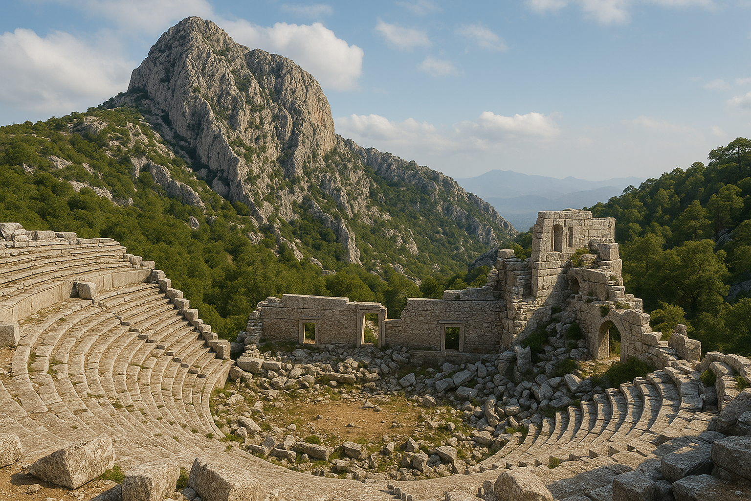
罗马神庙的卓越保存。 与大多数神庙仅以基础形式幸存的古城不同,阿达达保留有两座仍然耸立的神庙建筑,其墙体高达数米。图拉真神庙以及皇帝与宙斯·迈吉斯托斯-塞拉皮斯神庙是整个皮西迪亚地区皇帝崇拜建筑中保存最完好的范例之一。在该遗址,总共有四座公元 2 至 3 世纪的皇帝神庙至今仍保存良好。
-
完整的城市街道肌理。 主柱廊街以大型多边形石块铺成,其原始走向与路面在长段距离上得以保存。这在安纳托利亚内陆遗址中相当罕见,使访客得以即刻在物理层面感受罗马时期的城市规划。
-
与塞巴斯特大道及圣保罗的联系。 阿达达位于连接皮西迪亚主要城市的道路网络之上,其中包括与罗马塞巴斯特大道相关联的路段。据信使徒保罗在其第一次传教旅程期间(约公元 46–48 年)曾途经此地区,使这座城市与古典学和早期基督教研究都相关。
-
一座活的考古实验室。 该遗址是苏莱曼·德米雷尔大学考古系持续进行调查工作的对象,产出了关于皮西迪亚城市化、宗教建筑及区域贸易网络的新数据。首次科学发掘于 2004 年在伊斯帕尔塔博物馆主持下进行,并由帕慕卡莱大学参与。
-
未受破坏的景观背景。 阿达达坐落在西陶鲁斯山脉的森林丘陵之间,远离现代开发。这种环境提供了一种异常沉浸式的体验,使人感受到一座古代山城曾经的面貌与氛围,超过 2,200 年的历史静静栖息在松林之中。
-
以石头记录的外交史。 在特尔梅索斯发现的一份协议记录了阿达达与特尔梅索斯之间结成的友好盟约,目的是共同对抗他们共同的敌人塞尔格——这是皮西迪亚高地复杂的城邦间政治的证据。
地理与环境
阿达达位于土耳其西南部 湖泊地区(Göller Bölgesi)崎岖地形中的一处高原。该遗址海拔约 1,200 米,被西陶鲁斯山脉典型的松树与雪松林环绕。
这座城市位于苏特楚莱尔县城东南约 28 公里 处,距埃伊尔迪尔湖约 35 公里。从伊斯帕尔塔–安塔利亚公路分出的一条次要道路可以抵达此地,经过萨格拉克村后即可到达当地称为 卡拉巴乌卢(Karabavlu,亦拼作 Karabavullu)的考古区。
从地理上看,阿达达位于北部皮西迪亚高原与南部潘菲利亚沿海平原之间的过渡位置。这一位置使其自然成为连接地中海岸与安纳托利亚内陆的贸易与交通路线上的中转站。欧律墨冬河水系(现代的科普吕河),最终在阿斯彭多斯附近入海,其源头位于阿达达附近的山脉中,这进一步将这座城市锚定在区域地理之内。
周围的地形多山且森林茂密。城市所在的高原在陡峭的山坡之间提供了相对平坦的区域,既具有农业潜力,也具有天然的防御优势。山中的水源维持着城市的人口,附近的森林为建造提供了木材。
气候为大陆性地中海气候,冬季凉冷多雪,夏季炎热干燥。从 11 月到 3 月气温可低于零度,并且在此海拔处降雪很常见。春季(4–5 月)和秋季(9–10 月)提供最舒适的参观条件,春季野花覆盖林地,秋季金色的光线则使废墟更显风韵。
历史年表
前希腊化时期的起源
"阿达达"这个名称几乎可以肯定源自皮西迪亚语,早于希腊人定居于此。本土的皮西迪亚人以其强烈的独立精神和尚武文化而闻名。虽然该城市确切的建立日期不详,但皮西迪亚名称的存在表明,该聚落在希腊化影响进入该地区之前就已存在。
希腊化时期(公元前 3–1 世纪)
关于阿达达最早已知的文献提及来自地理学家 以弗所的阿尔特弥多罗斯,由 斯特拉博 引述,其将阿达达列为皮西迪亚的城市之一。地理学家 托勒密 也确认了它的存在。
在特尔梅索斯发现的一份公元前 2 世纪协议文件表明,阿达达当时已是一座成熟的城邦,并与皮西迪亚的城邦之间保持着外交关系。这一条约确立了阿达达与特尔梅索斯之间的友谊,以共同对抗他们共同的对手塞尔格——揭示了皮西迪亚高地竞争性的政治格局。
在晚期希腊化时期,阿达达开始铸造自己的钱币,这是政治自治与经济活动的标志。最早的钱币年代为 公元前 1 世纪,其图案如戴狮皮的赫拉克勒斯头像。
罗马时期(公元 1–3 世纪)
在罗马统治下,阿达达经历了其最辉煌的纪念性建筑时期。在庞培重组东方行省之后,该城市被纳入罗马行省体系。广场以石板铺设,主要神庙也相继兴建:
- 约公元 110–114 年: 图拉真神庙 建成,供奉被神化的图拉真皇帝。这是皮西迪亚至今幸存最精美的皇帝崇拜神庙之一。
- 约公元 160 年: 根据铭文证据,皇帝与宙斯·迈吉斯托斯-塞拉皮斯神庙 建成。这一双重供奉反映了罗马时期安纳托利亚的宗教融合文化。
- 公元 2–3 世纪: 进一步的公共建筑陆续兴建,包括议事厅(bouleuterion)、纪念性喷泉(nymphaeum)、露天集会区,以及皇帝与阿芙罗狄忒神庙。
阿达达的皇帝铸币始于 图拉真时期(公元 98–117 年),并延续至 瓦勒良与加里恩努斯时期(公元 253–268 年),造币活动跨越约 170 年。钱币种类丰富——以宙斯、雅典娜、狄俄尼索斯、塞拉皮斯、狄俄斯库洛伊兄弟以及六柱式神庙正立面为图案——表明这是一个繁荣且宗教多元的社区。
晚期罗马与拜占庭时期(公元 4–7 世纪)
随着基督教在安纳托利亚的传播,阿达达的异教神庙逐渐被弃用。一座巴西利卡教堂的建造,表明该城市向基督教社区的过渡。在阿达达的不同区域已识别出多座教堂建筑,其中规模最大的位于城市所在山谷的西部。
该遗址在拜占庭早期似乎逐渐被废弃,尽管确切的时间表与原因仍不清楚。可能的因素包括经济衰退、贸易路线的转移以及该时期普遍的不稳定。
古代之后
与许多被中世纪或现代聚落覆盖建造的古城不同,阿达达仅是被遗弃了。没有后来的居住活动扰乱古代遗存。这种被忽略反而保证了其罗马时期建筑的卓越保存,使它们慢慢被陶鲁斯森林所包围。
主要纪念物与建筑
图拉真神庙
图拉真神庙是阿达达最具标志性的建筑,也是皮西迪亚地区保存最完好的罗马神庙之一。它建于约 公元 110 至 114 年,供奉被神化的图拉真皇帝的崇拜。
该神庙采用 前柱式平面,正面入口设有列柱。其墙体高耸,可见用精心修整的方石砌成的石层。前廊(pronaos)和内殿(cella)清晰可辨。建筑残件,包括科林斯柱头与檐部构件,散落在结构周围。
神庙的朝向以及它在广场建筑群中的位置表明,它曾是皇帝崇拜仪式与公共集会的焦点。2004 年在伊斯帕尔塔博物馆主持下进行的发掘揭示了此前未知的神庙圣区部分。
皇帝与宙斯·迈吉斯托斯-塞拉皮斯神庙
该神庙位于广场附近,根据献辞铭文,建于约 公元 160 年。对罗马皇帝与融合神祇宙斯·迈吉斯托斯-塞拉皮斯的双重供奉,反映了 2 世纪安纳托利亚希腊、埃及与罗马宗教传统的融合。
塞拉皮斯崇拜在罗马帝国东部广泛存在,它出现在像阿达达这样的山城中,表明这些融合传统深入到了行省生活中。该神庙的建筑显示出科林斯式的影响,与图拉真神庙一起,是该城市在帝国盛期繁荣的见证。
皇帝与阿芙罗狄忒神庙
第三座神庙,供奉皇帝与阿芙罗狄忒,已在一处此前被认作行政宫殿的建筑东侧识别出来。其保存状况不如其他两座神庙,但它仍丰富了阿达达作为一座具有丰富多元宗教景观之城的图景。
第四座皇帝神庙
在该遗址识别出第四座帝国时期的神庙,使保存良好的皇帝神庙总数达到四座——对于阿达达这种规模的城市而言,这是异常高的集中度,也进一步证明了皇帝崇拜在皮西迪亚城市中的重要性。
广场与集市
阿达达公共生活的核心是其铺石广场与集市建筑群。集市位于卫城以西,在希腊化与罗马帝国初期作为城市的商业、行政与宗教中心。
在公元前 2 世纪城市最初建造期间,集市北侧设有一座多层、双廊柱廊,南侧则为单廊柱廊。广场的铺路石,许多仍位于原处,是紧密拼合的大型不规则多边形石块,呈现出罗马行省建筑的典型风格。
柱廊主街
一条宽阔的石板路穿过城市,两侧排列着曾支撑覆顶柱廊的柱础。这条街道连接着主要的公共建筑,赋予该遗址其特有的线性组织。今日漫步其上,访客可以追踪近两千年前商人、官员与朝拜者所走过的同一条路径。
剧场
剧场建在阿达达所在平原西北部山丘的斜坡上。观众席(cavea)仍然可见,雕凿入天然山坡之中。目前估计其容量约为 1,000 名观众——相对于主要城市规模较小,但适合一座山地社区。剧场的位置可以俯瞰周围森林与山脉的全景,使其成为土耳其氛围最为独特的古代剧场之一。
议事厅(Bouleuterion)
议事厅是城市治理机构开会的场所,可通过其凿入基岩中的半圆形座位排列加以识别。虽然规模小于大都会中心的议事建筑,但它见证了阿达达作为一个拥有正式民主制度的自治城邦的地位。
纪念性喷泉(Nymphaeum)
一座宁芙泉建筑为该城市提供了公共供水系统。具有装饰立面的纪念性喷泉是繁荣罗马城市的标准特征。建筑装饰的残片仍然可见,包括带有水道的雕刻石块。
巴西利卡与教堂
一座基督教巴西利卡,年代为晚期罗马或拜占庭早期,是该城市宗教转变的见证。其建造可能再利用了早期异教建筑的材料,这是整个安纳托利亚的常见做法。在城市的不同区域已识别出更多的教堂建筑,其中最大的巴西利卡位于山谷的西部。
墓地
该城市的墓地区域包含多种墓葬类型,包括岩凿墓和石棺。墓地中的丧葬铭文为阿达达居民的姓名、职业以及家族结构提供了宝贵数据。这些铭文主要为希腊文,反映了城市精英阶层希腊化的文化。
卫城
该城市的最高点作为其卫城,可通过一条保存完好的石阶梯从集市区上行抵达。卫城可能曾设有防御工事,或可能设有瞭望塔,可俯瞰周围的景观以及穿越山间隘口通往该城市的进路。
露天集会区
在广场建筑群附近识别出一处露天集会场所,作为公共集会与社区聚集的空间,补充了较为正式的议事厅。
钱币与经济
阿达达的钱币学记录为其经济与政治地位提供了重要证据:
-
晚期希腊化钱币(公元前 1 世纪): 该城市开始铸造自己的青铜币,图案如戴狮皮的赫拉克勒斯头像以及戴头盔的有须头像。钱币的发行表明阿达达已获得足够的政治自治权与经济实力,可以拥有自己的货币体系。
-
皇帝时期钱币(图拉真至瓦勒良/加里恩努斯,公元 98–268 年): 在约 170 年内产生了一系列丰富的钱币。钱币类型包括坐姿宙斯、雅典娜半身像、坐于地上的狄俄尼索斯、被蛇缠绕的圣篮(cista)并带有 BACCHEIA 铭文、塞拉皮斯半身像、坐姿塞拉皮斯、站立的狄俄斯库洛伊兄弟,以及六柱式(六根柱子)神庙正立面。
钱币上宗教图像的多样性映照了该城市神庙中崇拜献礼的多样性。某些钱币上描绘的六柱式神庙很可能代表了该遗址中某座实际的神庙,为建筑学证据提供了钱币学的确认。
该城市的经济基础包括农业(适合山地气候的谷物与橄榄)、畜牧业(尤其是在高山牧场中的山羊与绵羊)、林业(周围的陶鲁斯森林提供了珍贵的木材),以及沿区域道路网络的贸易。它位于沿海与内陆之间的路线上,使其成为潘菲利亚与皮西迪亚高地之间货物流通的天然交换点。
钱币与神庙供奉中都出现塞拉皮斯图像的现象表明其与更广泛的地中海贸易网络存在联系,因为塞拉皮斯崇拜在希腊化与罗马时期与商业及航海密切相关。
考古工作
早期探索
阿达达最早由欧洲学者 A. 舍恩博恩于 1842 年 来访,使其成为最早被西方旅行者记录的皮西迪亚遗址之一。美国探险家 J. R. S. 斯特雷特 在 1884 年 重新发现并描述了该废墟,在其《小亚细亚铭文之旅》(An Epigraphical Journey in Asia Minor,1888 年)中发表详细记述,将该遗址纳入了更广泛的学术关注。
1887 年,德国学者 古斯塔夫·赫希费尔德 和英国历史地理学家 威廉·M. 拉姆齐 进一步确认该遗址即为古代阿达达。拉姆齐在小亚细亚历史地理方面的广泛工作,尤其是其里程碑式著作《小亚细亚历史地理》(The Historical Geography of Asia Minor,1890 年),将阿达达稳固地置于皮西迪亚研究的学术框架之内。
现代调查工作
近几十年来,位于伊斯帕尔塔的 苏莱曼·德米雷尔大学考古系 在阿达达进行了系统的调查工作,对该遗址的纪念物、铭文与城市布局进行了新的记录。这一持续项目促进了对皮西迪亚地区城市规划、宗教建筑与物质文化的更深入理解。
2004 年的发掘
阿达达的首次科学发掘于 2004 年 在 伊斯帕尔塔博物馆 主持下进行,并由 帕慕卡莱大学考古系 参与。这些发掘揭示了剧场、集市与图拉真神庙圣区中此前未知的部分,显著扩展了对该城市布局与建筑史的理解。
目前状况与未来潜力
除了 2004 年的工作之外,该遗址尚未进行大规模持续性发掘,这意味着可见的遗存大多停留在地表层面。这也意味着重要的考古沉积可能仍未受扰动地保存于地表之下,代表着未来研究的巨大潜力。
该遗址偏远的位置既使其免受开发压力,也限制了基础设施与保护方面的投入。在土耳其考古界已讨论过更系统的发掘与遗址管理的提案,但资金与该山地地形上的后勤挑战拖慢了进展。
游客信息
如何到达
从伊斯帕尔塔市中心出发,向南驱车前往苏特楚莱尔(约 80 公里)。从苏特楚莱尔继续向东南行驶约 28 公里,途经萨格拉克村。最后一段路是一条未铺设的林间道路(约 5 公里),在干燥条件下普通汽车可通行,但雨后需谨慎驾驶。在雨季月份建议使用四驱车。
从安塔利亚出发,沿陶鲁斯山脉经科普吕峡谷向北行驶约 140 公里。从埃伊尔迪尔出发,距离约 60 公里向南。
最佳参观时间
- 春季(4–5 月): 野花覆盖林地,气温舒适(15–25 摄氏度),周围群山视野清晰。
- 秋季(9–10 月): 气候宜人,金色光线穿透松树,游客较少。
- 夏季(6–8 月): 炎热但在此海拔(约 1,200 米)尚可接受;建议早出发以避开正午高温。
- 冬季(11–3 月): 降雪常见且可能很大;通行道路可能不可通行。除非具备冬季驾驶经验与装备,否则不推荐前往。
时长
完整的参观需要 2 至 3 小时。请为摄影与林间道路上的缓慢驾驶留出额外时间。更细致的探索,包括墓地、所有四座神庙以及周围地形,可能需要半天时间。
设施
该遗址为露天且未围合。废墟本身没有售票处、洗手间、咖啡馆或遮阳设施。访客应自备饮用水、零食、防晒用品以及结实的徒步鞋。地形崎岖不平,散布着石块与杂草丛生的区域。
最近的服务设施(餐厅、加油站、基本住宿)位于苏特楚莱尔。更舒适的酒店可以在埃伊尔迪尔或伊斯帕尔塔找到。
附近景点
- 科瓦达湖国家公园(约 15 公里)——森林环绕的风景湖泊
- 埃伊尔迪尔湖(向北约 60 公里)——土耳其第四大湖,以薰衣草与苹果园闻名
- 津丹洞穴(位于苏特楚莱尔附近)——一处重要的喀斯特洞穴系统
- 亚泽勒峡谷自然公园——一处壮观的河流峡谷,设有徒步小径
- 其他皮西迪亚遗址:萨加拉索斯(发掘最充分的皮西迪亚城市)、克雷姆纳、皮西迪亚的安提阿(亚尔瓦奇)
常见问题
是什么让阿达达与其他皮西迪亚古城不同?
阿达达的与众不同之处在于其罗马神庙的卓越保存——四座皇帝神庙以非凡良好的状态幸存,尤其是图拉真神庙以及宙斯·迈吉斯托斯-塞拉皮斯神庙。虽然萨加拉索斯和皮西迪亚的安提阿等城市规模更大、发掘也更广泛,但阿达达提供了一种无与伦比的体验:在完全自然、未开发的森林环境中漫步于一座完整的罗马行省城市景观之中。
阿达达与圣保罗有关联吗?
该城市位于使徒保罗在其第一次穿越皮西迪亚的传教旅程期间(约公元 46–48 年)所经过的更广泛区域内。虽然《新约》中并未提到阿达达之名,但该城市位于区域道路网络——塞巴斯特大道及其连接路线——之上,因此保罗或其同伴穿过或经过该遗址附近是可信的。
我可以在没有向导的情况下参观阿达达吗?
可以。该遗址开放且无人看守,没有正式入口。然而,现场没有信息牌,因此强烈建议提前用导览书或下载的资料做好准备。一位熟悉皮西迪亚考古的知识渊博的向导会大幅提升体验,因为许多建筑结构需要解释才能充分欣赏。
这座古城有多大?
阿达达跨越高原占据了相当大的面积,城市核心区沿柱廊街延伸数百米。周围的墓地、农业台地以及外围建筑进一步扩展了考古区。完整步行游览所有可见遗存约需 2–3 公里。
参观需要多长时间?
请在遗址上预留至少 2 小时,再加上从苏特楚莱尔前往的车程(在林间道路上单程约 45 分钟)。更细致的探索可能需要半天时间。
是否需要门票?
根据近期报道,目前无需门票。该遗址未围合,全年可进入,视天气而定。
应该穿什么?
结实的封口鞋是必需的。地形包括松散的石块、不平的铺路面以及可能有带刺植物的杂草丛生区域。夏季请携带防晒用品和帽子;过渡季节请携带分层衣物以应对多变的山区天气。建议穿长裤以防蓟与昆虫。
该遗址安全吗?
该遗址本身对游客而言是安全的,但偏远的位置意味着在某些区域没有手机信号,附近也没有紧急服务。出行前请告知他人您的计划。在温暖月份请注意蛇类,因为多石的地形为它们提供了栖息地。
文化与宗教生活
阿达达的四座皇帝神庙讲述了一个关于一座相对较小的山城中宗教多样性的非凡故事。同时存在献给被神化的图拉真皇帝、融合神祇宙斯·迈吉斯托斯-塞拉皮斯以及阿芙罗狄忒的崇拜,表明阿达达并非孤立的偏僻之地,而是一个充分参与更广泛罗马世界宗教潮流的社区。
塞拉皮斯崇拜 尤为重要。它起源于托勒密时期的埃及,是希腊与埃及宗教传统有意融合的产物,对塞拉皮斯的崇拜通过贸易网络传遍地中海。它出现在像阿达达这样的皮西迪亚山城中,要么表明与埃及存在直接的贸易联系,要么更可能是该崇拜在大型安纳托利亚港口城市的文化影响所及。
阿达达钱币上的 巴库斯式图像——包括被蛇缠绕的神秘篮(cista mystica)以及 BACCHEIA 铭文——表明城内也实行狄俄尼索斯神秘仪式。此类神秘崇拜向入会者提供精神转化与来世福报的承诺,其在罗马帝国各地的流行有充分的记载。
向基督教的过渡,由多座教堂的建造为证据,似乎是渐进的。基督教建筑中对异教建筑材料的再利用——一种称为"再用石材"(spolia)的做法——在阿达达可以看到,既反映了实用主义,也反映了新宗教秩序对旧宗教秩序在象征上的接管。
城市行政
作为一座自治城邦,阿达达维持着标准的希腊城邦机构:
- 议会(boule)在议事厅集会。
- 公民大会(demos)在露天集会区聚集。
- 由选举产生的 行政官 负责城市行政、财政与公共工程。
- 一所 造币厂 在皇帝授权下铸造该城市的钱币。
该城市与邻近城邦的外交往来,记录于特尔梅索斯协议中,表明阿达达参与了希腊化与罗马时期皮西迪亚地区城邦间关系的复杂体系。
塞巴斯特大道与区域道路网络
塞巴斯特大道是公元前 1 世纪末在加拉太总督主持下修建的一条主要罗马道路,连接了安纳托利亚南部的殖民城市。虽然主线穿过皮西迪亚的安提阿和皮西迪亚湖泊地区,但次级道路分出,将像阿达达这样规模较小的城市连接进了这一网络。
阿达达位于这些次级路线之上,使其得以通向区域市场,并确保货物、思想与人员穿过该城市的流动。今日幸存的石板主街几乎可以确定是这一道路网络的一部分,按照轮式交通与军事调动所需的标准设计建造。
道路网络也促进了基督教在皮西迪亚的传播。使徒保罗的传教旅程沿罗马道路而行,福音信息沿这些相同的交通动脉抵达该地区的城市。
阿达达的钱币——公民身份的视觉记录
阿达达的青铜钱币为该城市在罗马帝国时期的宗教生活、文化关联与政治效忠提供了异常丰富的视觉记录。钱币学证据对于理解像阿达达这样的城市至关重要,在那里文献来源稀少。
皇帝肖像与行省效忠
阿达达钱币的正面通常铸有在位罗马皇帝或皇后的肖像,展示了该城市的政治效忠。这些肖像遵循标准的皇帝图像学,但由本地工匠雕刻,有时呈现出风格上的变化,使阿达达钱币与其他造币厂的钱币有所区分。
背面类型的宗教图像
背面类型揭示了该城市的宗教景观:
- 坐于宝座上的宙斯——确认宙斯为该城市的主神。
- 得墨忒耳与珀尔塞福涅——反映周围高地谷物生产的农业重要性。
- 塞拉皮斯——展示与更广泛的地中海宗教世界的联系。
- 狄俄尼索斯与巴库斯象征——包括带有 BACCHEIA 铭文的神秘篮(cista mystica),表明实行神秘仪式。
- 河神或当地神祇形象——将公民身份与自然景观相联系。
钱币告诉我们什么
对于像阿达达这样几乎没有铭文被发现、也没有古代文献详细描述该城市的城市而言,钱币是主要的历史文献。每一种钱币类型都由市议会批准,使钱币图像成为公民身份的官方声明——即该城市的领导者希望让外界知晓有关其社区的内容。
钱币流通超越了城市边界,作为微型的大使宣示阿达达的财富、虔诚与文化精致,向更广泛的罗马世界发声。
建筑测量与关键数据
下表汇编了阿达达纪念物的主要文献记载尺寸与统计数据,基于苏莱曼·德米雷尔大学的调查数据与已发表的发掘报告。
| 特征 | 测量 / 数量 |
|---|---|
| 广场 / 集市尺寸 | 32 x 45 m |
| 遗址海拔 | 约 1,200 m |
| 距苏特楚莱尔的距离 | 约 28 km 东南 |
| 距埃伊尔迪尔湖的距离 | 约 35 km 南 |
| 剧场估计容量 | 约 1,000 名观众 |
| 已保存的皇帝神庙 | 4 |
| 皇帝铸币跨度 | 图拉真(公元 98 年)至瓦勒良/加里恩努斯(公元 268 年),约 170 年 |
| 所有可见遗存的步行游览 | 约 2–3 km |
| 集市北侧柱廊 | 多层、双廊设计 |
| 集市南侧柱廊 | 单廊设计 |
钱币学证据——详细目录
阿达达的钱币为该城市的政治与宗教身份提供了最丰富的证据体系。下表根据 WildWinds 数据库和 SNG Von Aulock 参考收藏汇编,目录列出了主要已知的钱币类型。
前皇帝时期(自治)钱币——公元前 1 世纪
| 正面 | 背面 | 参考 |
|---|---|---|
| 戴月桂冠的宙斯右向头像 | 站立向左的尼刻,手持棕榈枝,用花环加冕战利品 | SNG Von Aulock -- |
| 有须的赫拉克勒斯右向头像,戴狮皮头饰 | 戴头盔、披衣的阿瑞斯右向半身像 | SNG Von Aulock -- |
| 正面的束带公牛头像,上方有星 | 三足旋臂(三腿符号) | SNG Von Aulock 4895 |
自治钱币带有铭文 ADADEY 或 ADA,确认了该城市希腊化的皮西迪亚名称。
皇帝时期钱币——图拉真至瓦勒良/加里恩努斯(公元 98–268 年)
| 皇帝 / 时期 | 正面 | 背面类型 | 铭文 |
|---|---|---|---|
| 图拉真(98–117) | 戴月桂冠的图拉真右向半身像 | 坐姿宙斯,手持权杖 | ADADEON |
| 哈德良(117–138) | 戴月桂冠的哈德良右向半身像 | 站立的雅典娜,手持长矛和盾牌 | ADADEON |
| 安东尼·庇护(138–161) | 戴月桂冠的右向半身像 | 坐于地上的狄俄尼索斯 | ADADEON |
| 马可·奥勒留(161–180) | 戴月桂冠的右向半身像 | 站立的得墨忒耳,手持麦穗和火炬 | ADADEON |
| 各 2–3 世纪 | 皇帝右向半身像 | 被蛇缠绕的神秘篮(圣篮),铭文 BACCHEIA | ADADEON |
| 各 2–3 世纪 | 皇帝右向半身像 | 坐姿塞拉皮斯,手持权杖 | ADADEON |
| 各 2–3 世纪 | 皇帝右向半身像 | 站立的狄俄斯库洛伊兄弟(卡斯托耳和波吕克斯) | ADADEON |
| 各 2–3 世纪 | 皇帝右向半身像 | 六柱式(六根柱子)神庙正立面 | ADADEON |
| 瓦勒良/加里恩努斯(253–268) | 戴月桂冠的右向半身像 | 各种类型 | ADADEON |
某些钱币背面所描绘的六柱式神庙具有特别的意义。这一六柱式正立面几乎可以肯定代表了至今仍矗立于阿达达的实际神庙之一,为今日现场可见的建筑学证据提供了钱币学的确认。巴库斯式图像(被蛇缠绕的神秘篮以及 BACCHEIA 铭文)的出现,在皮西迪亚钱币中是独一无二的,表明该城市内活跃着狄俄尼索斯神秘崇拜。
铭文与外交史
阿达达的铭文记录虽然与更大的皮西迪亚城市相比规模有限,但为该城市的政治生活与城邦间关系提供了重要证据。
特尔梅索斯联盟铭文
与阿达达相关的最重要的外交文献是在 特尔梅索斯——位于现代安塔利亚附近的强大山城——发现的一份 共同公民权(isopoliteia)协议。该铭文记录了阿达达与特尔梅索斯之间正式的 友谊盟约,旨在共同对抗其共同的敌人 塞尔格——这是一座控制欧律墨冬河上游谷地的对手皮西迪亚城市。
该条约揭示出皮西迪亚的城邦间政治以变动的联盟与对立为特征,像阿达达这样规模较小的城市结成联盟以制衡更强大的邻居。这一联盟策略反映了更广泛的希腊化国际关系模式,即较小的城邦通过双边条约与共同防御协议来寻求安全。
丧葬铭文
墓地中出土的铭文主要为 希腊文,反映了城市精英的希腊化特征。这些文本提供了以下证据:
- 既有希腊起源也有本土皮西迪亚起源的人名
- 家族结构与世系模式
- 职业头衔与公民职位
- 标准希腊丧葬套语与当地习俗并用
铭文中希腊与皮西迪亚命名惯例的共存,展示了罗马化的皮西迪亚高地所具有的文化混合性——一种世代之间本土传统与希腊罗马文化共存的社会。
早期探索年表
| 年份 | 探险家 / 学者 | 贡献 |
|---|---|---|
| 1842 | A. 舍恩博恩 | 第一位记录该废墟的欧洲访客 |
| 1884 | J. R. S. 斯特雷特(美国) | 重新发现并描述了该遗址;发表于《小亚细亚铭文之旅》(1888 年) |
| 1887 | 古斯塔夫·赫希费尔德(德国)与威廉·M. 拉姆齐(英国) | 确认为古代阿达达;拉姆齐发表于《小亚细亚历史地理》(1890 年) |
| 2000 年代 | 苏莱曼·德米雷尔大学,伊斯帕尔塔 | 对纪念物与铭文的系统考古调查 |
| 2004 | 伊斯帕尔塔博物馆 / 帕慕卡莱大学 | 对剧场、集市与图拉真神庙圣区的首次科学发掘 |
斯特雷特 1884 年的重新发现是一次跨越小亚细亚的更广泛铭文学考察的一部分,该考察记录了数十处此前未被记录的古代遗址与铭文。其出版物至今仍是皮西迪亚铭文学与历史地理研究的奠基性来源。
资料来源与延伸阅读
- 阿达达(皮西迪亚)—— 维基百科
- 苏莱曼·德米雷尔大学 —— 阿达达古城调查
- Alaturka Info —— 阿达达:被遗忘之城中的巴西利卡与皇帝神庙
- WildWinds —— 皮西迪亚,阿达达古代钱币
- 拉姆齐,W. M. ——《小亚细亚历史地理》(1890 年)
- 斯特雷特,J. R. S. ——《小亚细亚铭文之旅》(1888 年)
- 斯特拉博,《地理学》,第十二卷 —— 论皮西迪亚诸城
- 托勒密,《地理学》—— 皮西迪亚城市的列举
- TripAdvisor —— 阿达达古城评论
- WowCappadocia —— 伊斯帕尔塔阿达达古城