扩展概述: 佩林托斯(Perinthos),后更名为赫拉克利亚(Heraclea),是马尔马拉海(普罗滂提斯)北岸最强大的古代城市之一。它于公元前 602 年作为萨摩斯殖民地建立,发展为一座有时甚至与拜占庭城相抗衡的重要商贸中心。该城位于今天泰基尔达省的马尔马拉埃雷利西,曾抵御马其顿腓力二世于公元前 340 年发动的著名围城,担任罗马欧罗巴行省的首府,并成为拜占庭世界最早、最重要的基督教都主教座之一。在 Zeynep Koçel Erdem 教授自 2021 年以来主持的近期发掘中,揭露了色雷斯最大的剧场(90 × 130 米),以及浴场、神庙、市集广场遗存和大规模城墙。据最新报道,剧场结构已发掘约四分之一,工作仍在持续进行,以期完整揭露该建筑。
目录
为什么 Perinthos-Heraclea 重要
-
盖过拜占庭的萨摩斯殖民地。 在几个世纪间,佩林托斯在商业上比邻近的拜占庭更为重要。其位于马尔马拉主要海上航线交汇处的战略位置,使其在整个古典时期皆是财富与政治影响力的中心。据史家普罗柯比记载,在君士坦丁堡崛起之前,它一直是欧罗巴行省最重要的城市。
-
抵抗腓力二世的英勇守城。 公元前 340 年腓力二世发动的围城是色雷斯历史上记载最为详尽的军事事件之一。城市在波斯与雅典支援下的成功防御展现了它的军事力量和外交触角,并促成通向公元前 338 年喀罗尼亚战役的连锁事件。佩林托斯之防成为古代军事史上被广为称道的研究案例。
-
罗马欧罗巴行省首府。 作为罗马欧罗巴行省的行政首府,佩林托斯(约公元 300 年更名赫拉克利亚)管辖着一片广阔的领土,其中包括后来成为君士坦丁堡的城市。该城的都主教曾在拜占庭升格为牧首之前主持其教区事务,而赫拉克利亚都主教在此后数百年间仍享有为君士坦丁堡牧首授圣职的特殊权利。
-
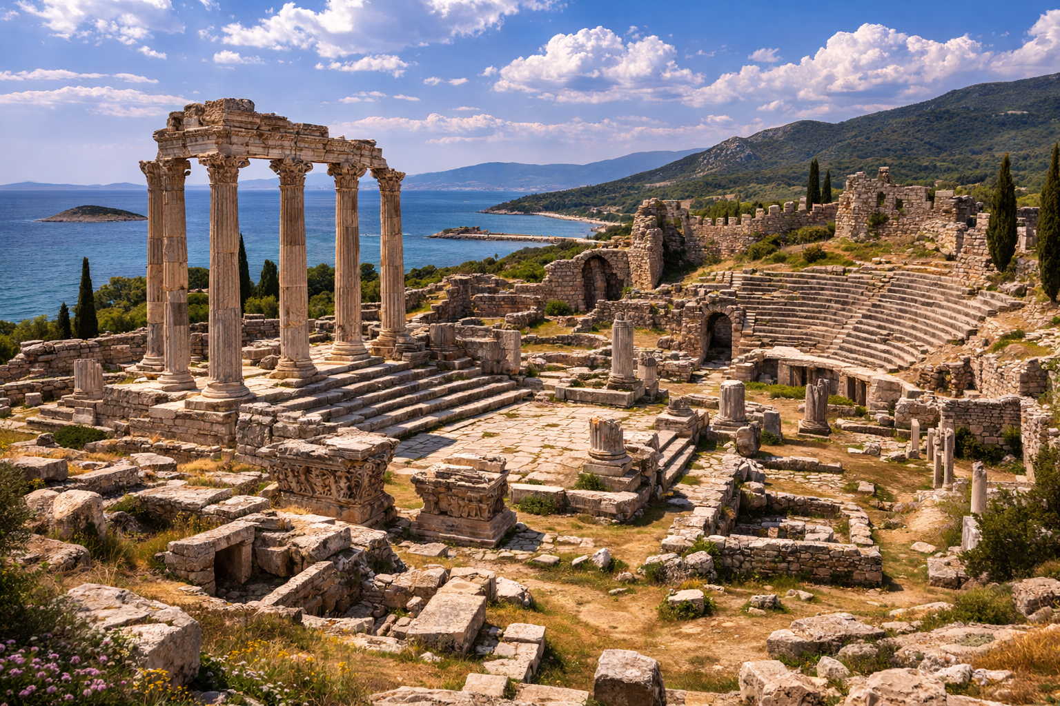
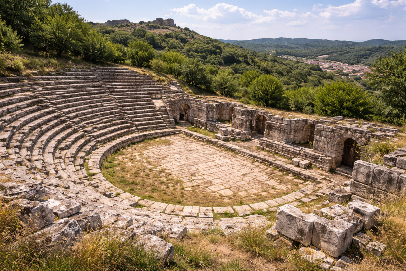
色雷斯最大的剧场。 新近发掘的剧场长 130 米、宽 90 米,是整个色雷斯地区已知最大的演出场所,见证了该城在罗马时期的文化抱负与人口规模。其估计可容纳 10000—15000 名观众,跻身古代地中海世界主要剧场之列。
-
自公元前 602 年至今的连续居住。 与许多被废弃的古城不同,马尔马拉埃雷利西自创建以来一直有人居住,形成了延续 2600 余年的非凡叠层城市记录。这种连续性既呈现出非凡的历史叙事,也带来了显著的考古挑战。
-
最丰富的古代钱币系列之一。 佩林托斯自古风时期至罗马帝国时期持续铸币,构成色雷斯任何一座城市中最完备的钱币学记录之一。这些钱币记录了近千年间的诸神、节庆、建筑特征与政治事件。
地理与环境
Perinthos-Heraclea 占据着马尔马拉海北岸一处显著的海岬,距伊斯坦布尔以西约 100 公里。古城坐落在一座向南伸入海中、地势陡峻的岩质半岛之上,东西两侧均提供天然港口设施。
地势自滨水带急剧上升,古卫城位于最高处,可俯瞰马尔马拉海全景。这一海拔较高、易守难攻的位置是该城得以抵御围城的关键——最著名的便是公元前 340 年腓力二世的进攻:陡峭的地形与坚固的城墙几乎使正面强攻无从下手。古代史料记述佩林托斯的房屋如剧场座阶般沿山坡层层升起,一道防线被攻破后,守军便据守下一排房屋继续抵抗。
该城地处埃格纳提亚大道(Via Egnatia)沿线——这是连接亚得里亚海与博斯普鲁斯海峡的大型罗马干道——使其成为陆海要道的关键交叉点。在巴尔干与小亚细亚之间往返的所有交通都需经过或途经佩林托斯,从过路税、港口费及贸易中产生持续的商业收入。
周围的腹地由肥沃的农业用地构成,向北延伸至色雷斯内陆。北部的埃尔格内河(Ergene River)流域提供额外的农业资源,并将城市与连接爱琴海至黑海的陆路贸易路线相通。马尔马拉的渔业以其在古代盛名远播的丰饶,亦是另一项重要的经济资源。
坐标: 约北纬 40.97 度,东经 27.95 度
海拔: 卫城海拔约 50—60 米;港口区域位于海平面。
气候: 地中海过渡型;夏季温暖干燥,冬季凉爽且多湿。海风缓和了夏季高温。夏季平均高温达 28—30 ℃,冬季低温很少跌破 3—4 ℃。温和的海洋性气候使佩林托斯一年四季皆为宜居之地。
当代背景: 今日的马尔马拉埃雷利西是泰基尔达省下辖的一个区,人口约 1.2 万。古代遗迹埋藏于现代城镇中心地下及其周边,使发掘成为复杂的城市规划课题。镇上每一项建设工程都可能揭露——也可能损毁——考古遗存。
历史年表
创建与古风时期(公元前 602—前 480 年)
佩林托斯由萨摩斯——爱奥尼亚希腊主要岛屿之一——的殖民者于公元前 602 年创建。选址极具战略意味:该海岬天然防御良好,两侧拥有良港,并扼守普罗滂提斯主要航道。
殖民地凭借海上贸易迅速繁荣,成为色雷斯沿岸最富庶的希腊城市之一。与本地色雷斯人的关系颇为复杂,既有贸易合作,也时有冲突。色雷斯腹地提供谷物、木材、金属与奴隶,佩林托斯将这些再转售至希腊世界。
该城自公元前 6 世纪晚期开始的早期铸币,其图案反映了海洋经济与宗教生活。萨摩斯母邦与殖民地保持数代文化联系,包括共同的宗教节日和艺术传统。
在波斯时期之前,该城曾遭受色雷斯佩奥尼亚人(Paeonians)的毁灭性袭击,希罗多德在《历史》中将其作为一次重大军事事件加以记载。
波斯统治与提洛同盟(公元前 480—前 340 年)
波斯战争期间,佩林托斯落入阿契美尼德的影响之下,成为色雷斯波斯总督辖区的一部分。其位于普罗滂提斯沿岸的战略地位对波斯帝国的通讯与军事后勤具有重要价值。
希腊在萨拉米斯与普拉提亚战役取胜后,该城恢复自治并加入由雅典领导的提洛同盟。公元前 5 世纪中叶的贡赋名单显示佩林托斯位列同盟缴纳成员之中,但其评估额因时而异。
该城自行铸造钱币,正面为女神头像(可能是赫拉,后期名称赫拉克利亚或与此有关,或为珀耳塞福涅),背面则有多种图案,包括骑马者。这些钱币是色雷斯希腊钱币艺术中最精美的代表之一,已被「Corpus Nummorum」项目详细编目。
腓力二世围城(公元前 340 年)
佩林托斯历史上最为人称道的事件,是其公元前 340 年对马其顿腓力二世的成功抵御。腓力围攻该城,意在掌控色雷斯沿岸与博斯普鲁斯海峡,以切断雅典自黑海运送的粮食生命线。
此次围城是一次重大军事行动:腓力部署了高达 80 英尺(约 24 米)的攻城塔——这是古代战争中所记载最高的攻城塔之一——攻城槌、坑道兵,以及约 3 万人的庞大军队。他将兵力分为多支轮战的突击队,昼夜不停地施压——这一具有创新性的战术,预示了后来希腊化时期的攻城战法。
然而,该城陡峭的地形、坚固的城防和顽强的守军使进攻举步维艰。佩林托斯的房屋如剧场座阶般沿山坡层叠而上,一道城墙被攻破后,守军便迅速封堵下一排房屋,形成临时的多层纵深防御。
至关重要的是,佩林托斯同时获得波斯(其大王下令西部诸总督施以援助)和雅典(派遣海军以保持港口畅通)的军事与物资支援。拜占庭人也派出士兵与补给,他们意识到佩林托斯若沦陷,自己将首当其冲。
经过长期作战,腓力意识到围城难以为继,转而退兵,将注意力转向附近的拜占庭(同样成功抵御)。佩林托斯之防成为古代军事史上一次被广泛称道的城市坚韧典范,狄奥多罗斯·西库鲁斯(第 16 卷)有详细记载,后世的军事著者也屡次援引。
希腊化时期(公元前 340—前 146 年)
亚历山大大帝去世后,佩林托斯先后归属若干希腊化继业王国,包括托勒密、塞琉古和安提柯王朝。该城保持着商业地位,并继续铸造钱币。
凯尔特人(加拉太人)于公元前 3 世纪初进攻色雷斯,佩林托斯极可能也受到此类侵扰威胁。这一时期城市格局有所扩展,新建公共建筑陆续出现,包括日后将成为纪念性剧场的奠基阶段。
罗马时期(公元前 146—公元 330 年)
在罗马统治下,佩林托斯成为欧罗巴行省(也称色雷斯欧罗巴)的首府,是罗马色雷斯的行政分区之一。约公元 300 年更名为赫拉克利亚,但两个名称并行延续了数百年。
罗马人对公共基础设施投入巨大:
- 修建纪念性剧场(90 × 130 米),为色雷斯最大者
- 建造规模宏大的公共浴场,多处建筑群服务于不同社区
- 为城市钱币上所尊奉的诸神兴建神庙
- 规划市集广场(agora),配以柱廊(stoa)
- 加固并扩展城墙,以容纳扩大的人口
- 建设引水道系统,将水源自北部高地引入城中
图拉真皇帝(在位 98—117 年)对该城特别恩宠,该城遂以图拉真家族之名 Ulpia 作为附加尊号。塞普蒂米乌斯·塞维鲁斯皇帝(在位 193—211 年)也偏爱此城,城中最精致的钱币便铸于其在位期间,其上描绘当地神庙与节庆场景。
后来的查士丁尼一世皇帝(在位 527—565 年)又重修了引水道和一处宫殿建筑群,显示出该城在早期拜占庭时期仍占据重要地位。
该城是罗马在巴尔干军事行动的重要集结点。其港口接收往返于罗马与东方诸省间的军队、补给与帝国访客。
早期基督教与拜占庭时期(公元 330—1453 年)
作为欧罗巴行省首府,赫拉克利亚是都主教座,对省内所有主教区——包括起初的拜占庭主教区——拥有教会权威。公元 330 年拜占庭升格为君士坦丁堡后,政治关系发生转变,但赫拉克利亚仍保有重要的宗教声望。
据传,基督教在使徒时代便已传入赫拉克利亚。该城的都主教在早期教会会议和教会政治中发挥了重要作用。赫拉克利亚都主教享有为君士坦丁堡牧首授圣职的特殊权利,此权延续数百年,凸显了这一古代主教座历史上的优越地位。
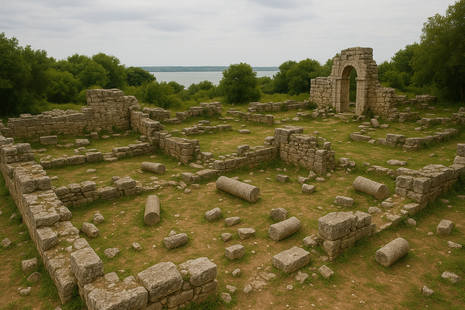
1992 年发现的一座晚期古代巴西利卡,为该城早期基督教遗产提供了考古证据。已发掘部分(包括前庭)的尺寸约为 51 × 24 米。遗址发现的阿纳斯塔修斯一世(491—518 年)皇帝钱币暗示其建造年代为公元 5 世纪末至 6 世纪初。该教堂可能毁于公元 591 年阿瓦尔人的袭击,随后由莫里斯皇帝(在位 582—602 年)重建,体现了拜占庭边境城市常见的毁坏与重建循环。
整个拜占庭时期,赫拉克利亚仍具战略意义,掌控着沿马尔马拉海岸通往君士坦丁堡的西部入口。该城屡遭保加尔人、阿瓦尔人、斯拉夫人和十字军侵扰,每次都在古城墙内重建。
**第四次十字军东征(1204 年)**期间,十字军攻陷君士坦丁堡并在该地区建立拉丁国家,该城受到重大损失。
奥斯曼时期与近现代(1453 年至今)
奥斯曼征服之后,该城被称为 Ereğli(源自赫拉克利亚),其后为与其他同名土耳其城市(卡拉迪尼兹埃雷利西、孔亚埃雷利西)相区分,逐渐定名为马尔马拉埃雷利西。现代城镇仍坐落在古代遗址之上,意味着大量考古遗产埋藏于今日的城市肌理之下。
奥斯曼时期,该镇作为一座规模适中的港口和农业中心存在。许多古代建筑材料——柱、刻有铭文的石块、大理石构件——被用于奥斯曼时期的建筑之中,在墙体和地基中形成了文明叠压的羊皮纸记录,在整座现代小镇随处可见。
主要遗迹
大剧场
现存最壮观的纪念性建筑是剧场,尺寸为长 130 米、宽 90 米。这是色雷斯已知最大的剧场,也是古代地中海世界规模较大的剧场之一,可与以弗所和米利都的大剧场相比拟。剧场依海岬的自然斜坡开凿而成,充分利用了陡峭地形。其观众席(cavea)估计可容纳10000—15000 名观众,可承担戏剧演出、音乐比赛和公共集会。发掘中已陆续从剧场建筑群中回收用大理石雕刻的舞台浮雕与雕塑。据近期报道,结构已暴露约四分之一,经历多个世纪堆积的土层和建筑碎石被逐步清理,台阶和座位逐渐显现。
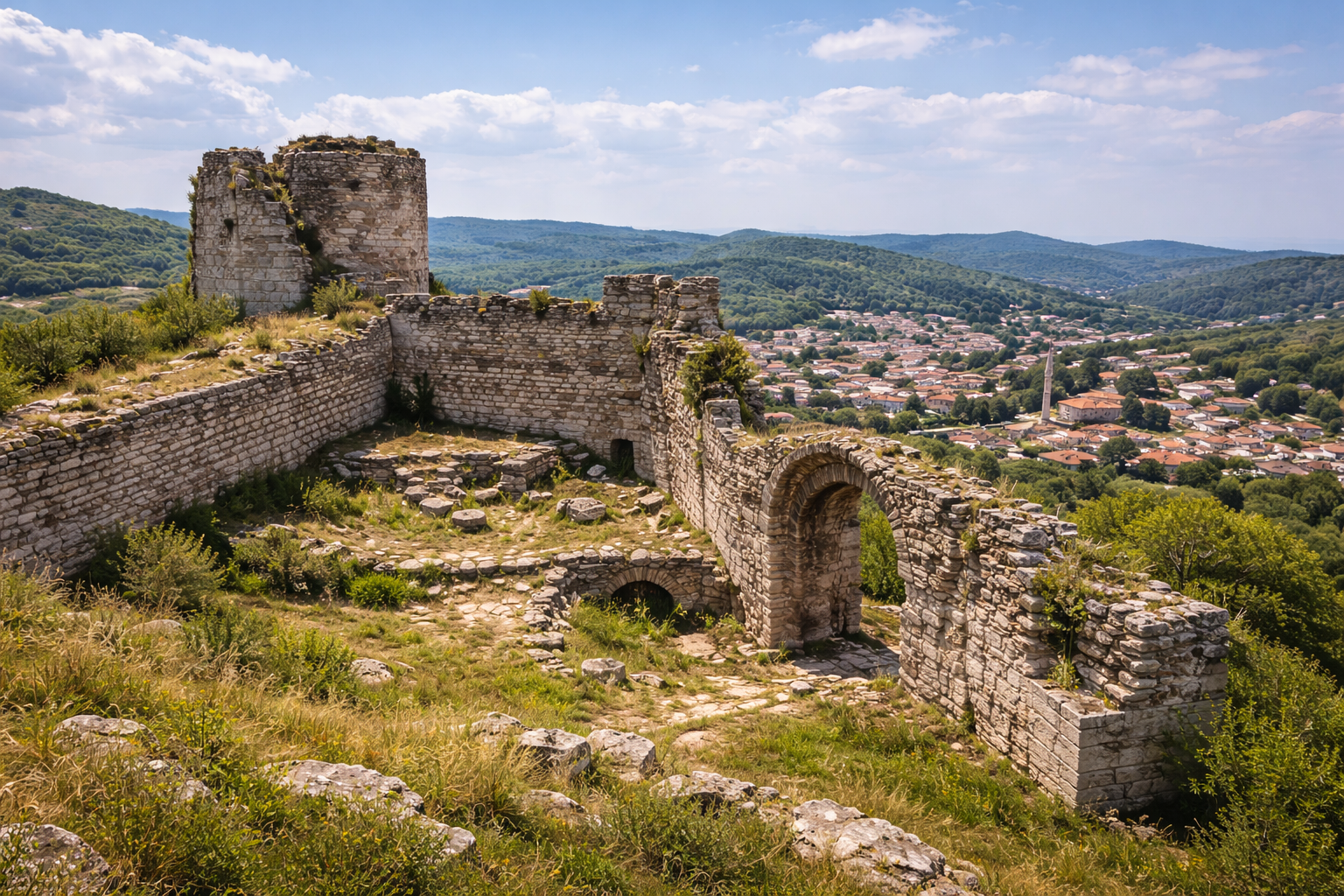
城墙与防御工事
古代防御体系环绕整座海岬,部分段落自希腊化时期延续至拜占庭时期。靠陆一侧(北侧)的城墙尤为坚固,因为该方向天然防御较弱。腓力二世在公元前 340 年未能突破这道城墙,正可见其工程之精湛。现存段落中可辨多个建造阶段,不同砌筑技法折射出数个世纪以来的修缮与扩建。该城墙是古色雷斯保存最完整的防御工事之一。
市集广场
Perinthos-Heraclea 的市民中心包括一座大型市集广场,兼作集市、集会场所和行政中心。考古证据显示其四周设有柱廊(stoa),并立有神庙、祭坛和公共铭文。市集广场是这座掌控马尔马拉主要贸易路线之城的商业心脏,繁盛地经销来自古代世界各地的商品。
公共浴场
遗址多处发现罗马时期浴场建筑群,体现了行省首府所应具备的标准市政设施。这些浴场兼具卫生与社交功能,是城市人口的聚会场所。浴场通常包括典型的罗马序列:冷水间(frigidarium)、温水间(tepidarium)和热水间(caldarium),并附设运动区与社交空间。
神庙
现存多座神庙地基,但所祭祀的具体神祇尚未一一识别。该城钱币显示其曾尊奉赫拉、赫拉克勒斯、得墨忒耳、阿波罗、Homonoia(和谐之神)和Tyche(命运女神)等。历史文献还提及一处与宗教仪式相关的圣洞或岩穴。帝国币上的「神庙守护者」(Neokoros)头衔表明该城担任省级帝国崇拜守护人的角色。
晚期古代巴西利卡
1992 年发现的这座早期基督教教堂,为该城作为重要都主教座的角色提供了实物证据。包括前庭在内,巴西利卡尺寸约为 51 × 24 米。阿纳斯塔修斯一世钱币提供了建造年代的下限。其毁损与重建(可能与公元 591 年阿瓦尔袭击及莫里斯皇帝资助相关)展现了拜占庭欧洲边境城市生活的挑战与韧性。
引水道系统
最初建于罗马时期、由查士丁尼皇帝修复的供水设施,将水源自北部高地引入城中。引水道的部分段落仍可于今日马尔马拉埃雷利西周边景观中辨识。其长度与工程证明了该城的庞大人口及其对可靠淡水供应的需求,用以为浴场、喷泉和家庭用水提供保障。
钱币与经济
佩林托斯所产钱币系列居色雷斯各城之首,自古风时期延续至罗马帝国,已被 Corpus Nummorum 项目详细编目,是古巴尔干地区有据可查的钱币学语料库中最完整者之一。
钱币的主要特征包括:
- 古风时期钱币(公元前 6 世纪末至前 5 世纪),具有早期希腊铸币特征的凹刻设计
- 古典时期钱币,正面为女神头像(赫拉或珀耳塞福涅),背面为骑马者,是色雷斯希腊钱币艺术中最精致的代表之一
- 帝国钱币,自奥古斯都至加里恩努斯时期,正面为皇帝肖像,背面为当地神祇、神庙或节庆场景
- 「神庙守护者」头衔出现在钱币上,宣告该城作为帝国崇拜的省级守护者地位,这一荣誉在各行省城市间竞争激烈
该城的财富源自:
- 沿普罗滂提斯航线连接爱琴海与黑海的海上贸易
- 来自肥沃色雷斯腹地的农产品,尤其是谷物
- 埃格纳提亚大道陆路上的过境税
- 古代以丰饶闻名的马尔马拉渔业
- 用于全区建筑的石材开采
考古工作
早期勘察
自 18 世纪以来,欧洲旅行者与学者对马尔马拉埃雷利西的可见遗迹有所记载。该遗址与古代佩林托斯/赫拉克利亚的对应关系,借由文献(希罗多德、斯特拉博、普林尼、普罗柯比)及金石材料得以确立。法国钱币学家 Ernest Babelon 等 19 世纪学者对该城钱币系列开展了广泛研究,为现代钱币学研究奠定基础。
1992 年巴西利卡发现
1992 年晚期古代巴西利卡的发现是一次重大事件,重新激发了学界对该遗址的兴趣。教堂的地层提供了阿瓦尔毁灭层及随后莫里斯重建的断代证据。前庭与中殿部分被发掘,揭露出马赛克地面与建筑装饰,确认了该建筑作为都主教教堂的地位。
现代发掘(2021 年至今)
系统性考古发掘自 2021 年起在 Zeynep Koçel Erdem 教授主持下展开。这些持续中的发掘聚焦于:
- 揭露并记录剧场,包括其座位、舞台建筑及周边设施——目前已暴露约四分之一
- 测绘城墙周圈,识别从希腊化至拜占庭时期的建造阶段
- 调查市集广场区域及相关市政建筑
- 记录涉及罗马、拜占庭和奥斯曼各时期的陶器、玻璃、金属器、钱币与建筑雕塑
- 记录剧场建筑群中以大理石雕刻的舞台浮雕与雕塑
- 开展地球物理调查(探地雷达和电阻率法),以测绘现代城镇下未发掘建筑
发掘由土耳其文化与旅游部资助,吸引了重要的学术与媒体关注——尤其是剧场的发现重塑了人们对古代色雷斯城市规模的理解。
保护挑战
Perinthos-Heraclea 面临的首要挑战是古城绝大部分埋藏于现代马尔马拉埃雷利西镇下方。发掘机会受到现代建筑、基础设施和私人产权的限制。这种「活城市」状态意味着考古工作必须与市政规划仔细协调。镇中心每一项建设工程都有可能揭露(或损坏)古代遗存,需要博物馆理事会持续监测。考虑到剧场规模巨大,完成全部发掘还需多年持续工作。
游客信息
交通方式
- 自伊斯坦布尔自驾: 沿 E-5/D100 高速公路向西经泰基尔达,约 2 小时。D100 直接穿过马尔马拉埃雷利西。
- 自埃迪尔内自驾: 沿 E-84 和 D100,约 2.5 小时。
- 乘公交: 伊斯坦布尔和泰基尔达之间有定班城际客运;当地小巴(dolmuş)继续前往马尔马拉埃雷利西。
- 海上: 目前无定期渡船服务,但港口区域可达。历史上,该城的双港曾是其生命线。
可参观项目
- 剧场发掘区(请向当地博物馆理事会咨询访问安排,因为这是正在进行中的发掘)
- 旧城西、南侧可见的防御城墙段
- 重新利用于全镇奥斯曼时期建筑中的建筑残件与铭文——一段可见的文明叠层
- 整体海岬地形,可让人体会公元前 340 年防御得以成功的战略背景
- 半岛东、西两侧的港口区域
- 巴西利卡遗址(访问可能因正在进行的保护工作而受限)
最佳访问时间
- 春季(4—6 月)与秋季(9—11 月):气温最为宜人,光线最佳。
- 夏季:温暖但因海风尚可应对;马尔马拉沿岸适合将考古与海边休闲相结合。
- 冬季:人少安静,但可能多风多雨;游客较少时更适合从容探访。
预计游览时长
预留 2 至 4 小时,可徒步走访可见遗迹、探察海岬并领略港口风貌。结合在临海当地鱼餐厅用餐,体验更为完整。该镇规模较小,徒步即可游览。
结合参观其他景点
- 泰基尔达市中心:省立博物馆藏有该地区考古藏品(向东 30 公里)
- 赫拉克利亚古道网络:经此地段的罗马埃格纳提亚大道支线痕迹
- 色雷斯葡萄园:泰基尔达地区是土耳其重要的葡萄酒产区之一,多家酒庄可供品鉴
- 拉克利杰(Raklice,古代 Rhaedestus):沿马尔马拉海岸的另一处古代聚落
- 伊斯坦布尔:大都市向东仅 2 小时车程,使马尔马拉埃雷利西可作为可行的一日游
常见问题
为什么该城有两个名字?
该城于公元前 602 年作为 Perinthos(佩林托斯)创建,约公元 300 年更名为 Heraclea(赫拉克利亚),可能是为纪念赫拉克勒斯(该城所主祭的诸神之一)。两个名字同时使用了数百年。今日土耳其语名称 Ereğli 源自赫拉克利亚,经由中世纪希腊语发音演变而来。
佩林托斯真的比拜占庭重要吗?
在古典时期与罗马早期的大部分时间内,确实如此。佩林托斯在商业上更繁忙,在政治上更显赫,在教会地位上也高于拜占庭。赫拉克利亚的都主教甚至拥有为君士坦丁堡牧首授圣职的权利。这种格局直到公元 330 年君士坦丁将拜占庭重建为君士坦丁堡之后才发生根本性转变,权力的重心从此永久迁移。
当时人口规模如何?
古代城市的人口估计存在不确定性,但剧场的规模(估计可容纳 10000—15000 人)与城墙范围表明,在罗马时期高峰,人口可能达到 3 万至 5 万。巴西利卡的规模(51 × 24 米)亦暗示着相当庞大的基督教信众规模。这样的数字使佩林托斯跻身古代色雷斯最大城市之列。
现在可以参观剧场吗?
剧场正在主动发掘,结构已揭露约四分之一。参观条件取决于当前的发掘季。请联系泰基尔达博物馆理事会或发掘团队,了解当前的参观安排。即便从周边街道,已发掘的观众席规模也颇为壮观。
剧场的浮雕如今在何处?
剧场舞台建筑的大理石浮雕与雕塑已在发掘中陆续回收。它们正在进行研究与文物保护,未来将在地方或区域博物馆背景中展出。
古港如今仍能使用吗?
古港盆地已不再作为商业港口使用,但整体港湾地形仍清晰可辨。今日的马尔马拉埃雷利西在大致与古代西港相同的位置上拥有一座小渔港,为这座城市的海事历史提供了切实的延续。
佩林托斯与埃格纳提亚大道有何关系?
埃格纳提亚大道是连接亚得里亚沿岸(今阿尔巴尼亚)与拜占庭/君士坦丁堡的大型罗马道路,全长超过 1000 公里。佩林托斯是该路东段的关键驿站,正处于该路与马尔马拉海岸路线的交汇处。这一陆海要道交汇之地,是其繁荣的核心,使该城成为罗马东部最重要道路上最重要的停靠点之一。
建筑测量与关键数据
| 特征 | 测量值/详情 |
|---|---|
| 剧场尺寸 | 140 × 110 米(与以弗所剧场相当) |
| 剧场估计容量 | 10000—15000 名观众 |
| 巴西利卡尺寸(含前庭) | 约 51 × 24 米 |
| 城墙周圈 | 沿整座海岬可循迹 |
| 卫城海拔 | 约 50—60 米 |
| 创建年代 | 公元前 602 年 |
| 距伊斯坦布尔 | 约 100 公里 |
| 距埃迪尔内 | 约 170 公里 |
| 攻城塔高度(腓力二世,公元前 340 年) | 至 80 英尺(约 24 米) |
| 腓力二世兵力估计 | 约 30000 人 |
| 现代城镇人口 | 约 12000 |
钱币学证据
佩林托斯所出钱币构成色雷斯任何一座城市中最完备的钱币学记录之一,自古风晚期延续至罗马帝国晚期——铸造史近千年。该钱币集的奠基性研究由 Edith Schönert-Geiss 于 1965 年出版(第 28—32 页),其后 Corpus Nummorum 在线项目已对完整类型学进行编目,并附详尽图像记录。
各时期币种系列
| 时期 | 金属 | 典型正面 | 典型背面 | 备注 |
|---|---|---|---|---|
| 公元前 6 世纪末—前 5 世纪 | 银 | 凹刻设计 | 多样 | 最早期发行,古风风格 |
| 公元前 5—前 4 世纪(古典) | 银 | 女神头像(赫拉或珀耳塞福涅) | 骑马者 | 色雷斯希腊钱币艺术中最精致者之一 |
| 公元前 4—前 3 世纪(希腊化) | 青铜 | 赫拉克勒斯头像 | 棍棒、狮皮 | 反映马其顿影响 |
| 公元前 1 世纪—公元 3 世纪(帝国) | 青铜 | 皇帝肖像 | 当地神祇、神庙、节庆 | 自奥古斯都至加里恩努斯的丰富系列 |
| 塞普蒂米乌斯·塞维鲁斯(193—211) | 青铜 | 皇帝胸像 | 神庙守护者神庙、船型 | 最精致的钱币;首次出现 Neokoros 头衔 |
| 塞维鲁斯·亚历山大 | 青铜 | 皇帝胸像 | 神话场景(狄俄尼索斯、阿里阿德涅) | 多样的背面图像学 |
神庙守护者(Neokoros)头衔
在公元 196 年协助塞普蒂米乌斯·塞维鲁斯成功对抗对立帝王佩斯肯尼乌斯·尼日尔之后,佩林托斯被授予享有声望的 Neokoros 头衔,意为该城作为帝国崇拜行省神庙的官方守护者。这一荣誉以两种形式醒目地出现在该城钱币上:一种是单独描绘的神庙守护者神庙图像,另一种是由城市女神(Tyche)在钱币背面捧持的小型神庙。
Neokoros 这一殊荣在各行省城市间竞争激烈,授予佩林托斯既确认了该城的政治忠诚,也确认了其在罗马行省体系中的持续重要地位。Corpus Nummorum 编目记录了塞维鲁斯之后多位皇帝时期展示神庙守护者神庙的多种钱币类型,包括 CN_Type2473、CN_Type2475、CN_Type2477、CN_Type2487 以及背面饰有船只的 CN_Type2548——这种图像学将该城的海事传统与其帝国崇拜角色联系在一起。
水下港口发现(2024—2025)
佩林托斯近期最重要的发现之一是在东侧(商用)港区识别出沉没的港口建筑。在 Zeynep Koçel Erdem 教授主持下,发掘扩展至包含水下考古调查,揭示出:
- 散落于海床的石棺与石块,表明因构造活动和海岸侵蚀,部分古代滨水带在数百年间沉入水下
- 在东港区检测到的港口结构,与古代文献所述该城的商业港(区别于西侧军用港)相符
- 60 米深处的沉船,借助配备传感器和探地雷达的**远程操控潜水器(ROV)**发现
- 海床上的建筑残件,包括柱段与加工过的石块,表明滨水附近的纪念性建筑在该城一次或多次毁灭性地震中坍入港湾
水下发现引发了关于佩林托斯港口设施原始范围及构造性沉降在多大程度上改变该城海岸地理的重要新问题。未来发掘季预计将更多侧重水下研究,有望揭露港口设施、仓库地基与更多沉船。
公元前 340 年围城:一项军事分析
佩林托斯对腓力二世的防御是公元前 4 世纪记载最为详尽的围城叙事之一,主要由狄奥多罗斯·西库鲁斯(第 16 卷)记录。除英勇抵抗的叙事之外,此次围城还提供了具体的战术与技术数据:
- 攻城塔:腓力部署高达 **80 英尺(约 24 米)**的攻城塔,是古典时代有记载的最高攻城器械之一。这些塔可使进攻方居高临下射击城墙守军,并在城垛上架设登城桥。
- 轮战突击单元:腓力将军队组织成多支突击分队,轮班发动进攻,昼夜不停地施压。这一创新做法——使精锐部队休整时由生力军轮替投入战斗——预示了后来希腊化时期的攻城技术,并展示出腓力的组织水平之精。
- 纵深防御:该城梯田式山坡地形天然形成纵深防御体系。当腓力的部队攻破外墙某段后,守军便据守下一排房屋,将层级上升的城市地形转化为连续的防御线。
- 联盟支援:防御得以成功在一定程度上得益于外部援助:波斯(大王下令西部诸总督送补给与士兵)、雅典(派遣海军以保持港口畅通用以再补给),以及拜占庭(派出士兵与军需,认识到自身存亡有赖于佩林托斯坚持下去)。
围城失败对腓力是重大战略挫折。它显示了马其顿攻城能力在面对拥有外部海上补给线的设防良好城市时的极限——这一教训影响了整个希腊化时期的攻城战法。
参考资料
- Wikipedia, "Perinthus." Link
- Wikipedia, "Siege of Perinthus." Link
- The Byzantine Legacy, "Herakleia." Link
- Livius.org, "Perinthus (Marmara Ereglisi)." Link
- Anatolian Archaeology, "Perinthos Ancient City with the largest theater in Thrace." Link
- Arkeonews, "Theater of Perinthos Ancient City to be unearthed." Link
- Hürriyet Daily News, "A quarter of Perinthos' ancient theater unveiled." Link
- Hürriyet Daily News, "Theater emerges as works continue in Perinthos." Link
- Perinthos Excavation Project Official Website. Link
- ToposText, "Perinthos (Thrace)." Link
- Corpus Nummorum, "Coin Typology of Perinthos." Link
- Kültür Portalı, "Perinthos Antik Kenti." Link
- Diodorus Siculus, Bibliotheca Historica, Book XVI(佩林托斯围城)
- Procopius, De Aedificiis(查士丁尼的修复工作)