Skrót: Kültepe — starożytny Kanesh — to monumentalny tell i osada dolnego miasta w pobliżu Kayseri w centralnej Turcji, gdzie znajdowała się staroasyryjska kolonia handlowa (karum), kwitnąca około 1950–1750 p.n.e. Ponad 23 500 tabliczek klinowych odnalezionych w prywatnych archiwach kupieckich czyni Kültepe najbogatszym źródłem korespondencji handlowej w starożytnym Bliskim Wschodzie i skarbnicą najstarszych zapisanych dokumentów w Anatolii. Stanowisko figuruje na tureckiej liście wstępnej UNESCO.
Spis treści
- Dlaczego Kültepe ma znaczenie
- Geografia i otoczenie
- Tło historyczne
- Staroasyryjska sieć handlowa
- Tell (höyük) – miasto Kanesh
- Dolne miasto (karum)
- Tabliczki klinowe
- Towary handlowe i szlaki
- Społeczeństwo i życie codzienne
- Sztuka i kultura materialna
- Wykopaliska archeologiczne
- Najważniejsze znaleziska i kolekcje muzealne
- Znaczenie dla studiów indoeuropejskich
- Informacje dla odwiedzających
- Często zadawane pytania
- Źródła i literatura uzupełniająca
Dlaczego Kültepe ma znaczenie
Kültepe zajmuje wyjątkowe miejsce w historii świata: to tu odkryto najstarsze dokumenty pisane znalezione na terenie Turcji, wyprzedzające królewskie archiwa Hetytów w Hattusie o kilka stuleci. Ponad 23 500 tabliczek klinowych i kopert z dzielnicy kupieckiej stanowi największy zbiór prywatnych tekstów handlowych na starożytnym Bliskim Wschodzie — w odróżnieniu od królewskich czy świątynnych archiwów znanych z innych mezopotamskich stanowisk, są to osobiste listy biznesowe, umowy, akta sądowe i korespondencja rodzinna zwykłych (choć zamożnych) kupców.
Tabliczki odsłaniają niezwykle wyrafinowaną międzynarodową sieć handlową łączącą Assur (na terenie dzisiejszego północnego Iraku) z dziesiątkami miast anatolijskich. Kupcy asyryjscy transportowali cynę (z Afganistanu lub Iranu) oraz tkaniny (z Mezopotamii) do Anatolii, wymieniając je na złoto, srebro i miedź. System ten działał w oparciu o kredyt, stopy procentowe, ubezpieczenia karawan, rodzinne spółki handlowe i proto-korporacyjne ramy prawne, które wyprzedzają współczesne praktyki handlowe o niemal cztery tysiąclecia.
Dla językoznawców Kültepe ma równie doniosłe znaczenie. Hetyckiе imiona własne i zapożyczenia pojawiające się w tekstach staroasyryjskich stanowią najwcześniejsze poświadczenie jakiegokolwiek języka indoeuropejskiego — przesuwając pisany zapis tej rodziny językowej do początku II tysiąclecia p.n.e.
Geografia i otoczenie
Kültepe leży na Równinie Kayseri w centralnej Kapadocji, około 20 km na północny wschód od centrum Kayseri. Tell (höyük) wznosi się około 20 metrów ponad otaczającą równinę, zajmując powierzchnię około 500 × 500 metrów u podstawy — jest to jeden z największych nasypów z epoki brązu w Anatolii.
Stanowisko zajmuje strategiczne położenie na skrzyżowaniu szlaków łączących Wrota Cylicyjskie (dostęp do wybrzeża Morza Śródziemnego), górny Eufrat, dolinę rzeki Halys (Kızılırmak) i wybrzeże Pontu. To węzłowe położenie uczyniło z Kanesh naturalny ośrodek handlowy.
Wulkaniczny szczyt Erciyes Dağı (góra Argaeus, 3917 m n.p.m.) dominuje nad horyzontem na południowym zachodzie. Żyzna równina otaczająca stanowisko zapewniała bogactwo rolnicze, a zasoby obsydianu i metali w regionie przyciągały handel dalekodystansowy już od okresu chalkolitu.
Tło historyczne
Wczesne osadnictwo
Osadnictwo w Kültepe sięga co najmniej późnego chalkolitu (IV tysiąclecie p.n.e.). Nasyp narastał przez ciągłe zamieszkiwanie w epoce wczesnego i środkowego brązu, osiągając skalę metropolitalną na początku II tysiąclecia p.n.e.
Okres staroasyryjskiej kolonii (ok. 1950–1750 p.n.e.)
Złoty wiek Kanesh zbiega się z ustanowieniem asyryjskich kolonii kupieckich w całej Anatolii. Miasto Assur nad Tygrysem wysyłało rodziny kupieckie, by zakładały stałe faktorie handlowe (karumy) w miastach anatolijskich. Karum Kanesh był siedzibą całej sieci, pełniąc funkcję centrum administracyjnego i dystrybucyjnego.
Co najmniej czterdzieści miast anatolijskich posiadało asyryjską obecność kupiecką w tym okresie, lecz Kanesh był stolicą — „Wielkim Karumem" — gdzie rozstrzygano spory, ustalano przepisy i redystrybuowano towary handlowe.
Okres hetycki
Po upadku systemu staroasyryjskich kolonii (ok. 1750 p.n.e.) Kanesh pozostał ważnym miastem. Anitta, wczesny król Hetytów (ok. 1750 p.n.e.), zdobył Kanesh i uczynił z niego swoją stolicę, zanim centrum władzy Hetytów przeniosło się do Hattusy. Tekst Anitty — odnaleziony w Hattusie, ale odnoszący się do wydarzeń w Kanesh — jest najstarszym znаnym dokumentem w języku hetyckim.
Staroasyryjska sieć handlowa
System karum stanowi pierwszą udokumentowaną międzynarodową sieć handlową na świecie:
Struktura
- Karum (l.mn.: karumy): wielkolepskie kolonie handlowe zlokalizowane tuż za murami miast anatolijskich, z samorządem opartym na asyryjskim prawie handlowym, podlegające jednak miejscowej władzy politycznej
- Wabartum (l.mn.: wabartums): mniejsze faktorie handlowe w mniej ważnych miastach
- Siedziba w Kanesh: centralny karum rozstrzygał spory między wszystkimi koloniami, standaryzował wagi i miary oraz pobierał podatki na rzecz Assur
Jak działał system
- Kupcy w Assur formowali karawany osłów załadowanych cyną i tkaninami
- Karawany pokonywały trasę ~1200 km przez góry Taurus do Anatolii (około 6–8 tygodni)
- Towary sprzedawano lub wymieniano w różnych karumach, głównie za srebro i złoto
- Metale szlachetne odsyłano z powrotem do Assur, gdzie cykl zaczynał się od nowa
- Cały system był finansowany prywatnie — nie wymagał udziału królewskiego ani świątynnego
Skala operacji
Tabliczki dokumentują indywidualne transakcje od małych pożyczek osobistych po duże przesyłki warte setki min srebra. Całkowity wolumen handlu był ogromny jak na początki II tysiąclecia p.n.e. — przez około 200 lat funkcjonowania systemu do Anatolii trafiały dziesiątki tysięcy kilogramów cyny i tkanin.
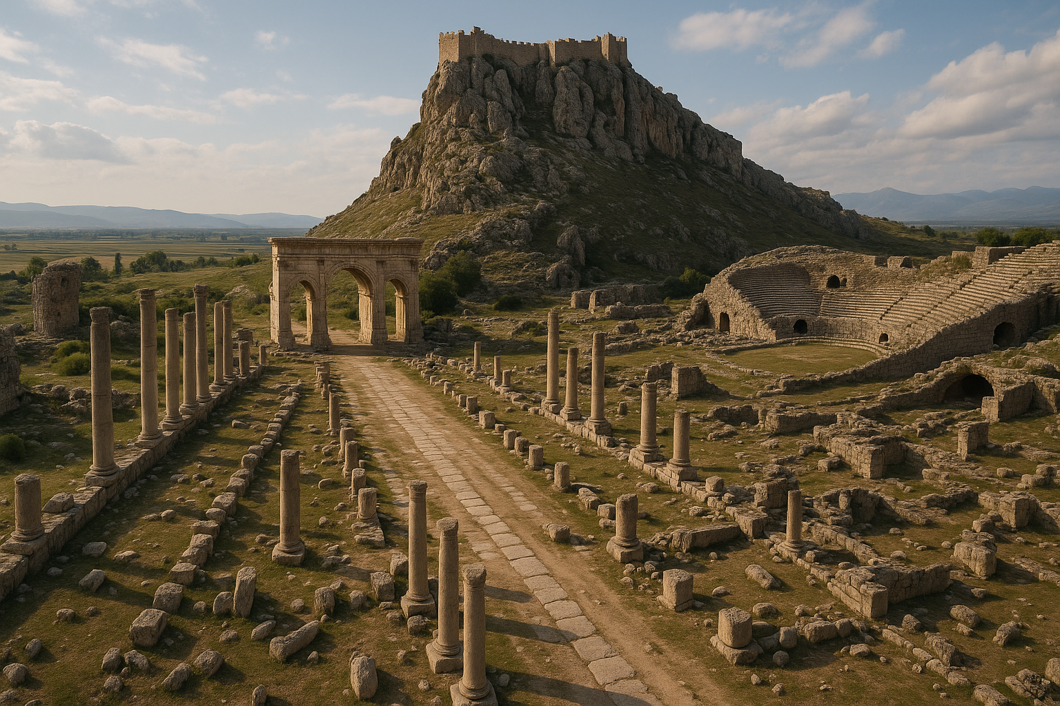
Tell (höyük) – miasto Kanesh
Główny nasyp (höyük) reprezentuje ufortyfikowane górne miasto Kanesh, siedzibę miejscowego króla anatolijskiego:
Kompleks pałacowy
Wykopaliska odsłoniły okazały pałac datowany na okres Kolonii (poziom II), z:
- Monumentalną architekturą z kamiennymi fundamentami i nadbudową z cegły suszonej
- Rozległymi magazynami (świadczącymi o scentralizowanej administracji gospodarczej)
- Odciskami pieczęci wskazującymi na biurokratyczne prowadzenie dokumentacji
- Śladami zniszczenia i odbudowy (miasto było dwukrotnie niszczone i odbudowywane)
Stratygrafia
Tell zawiera co najmniej 20 poziomów zasiedlenia, od chalkolitu do epoki żelaza. Najważniejsze dla okresu karum są:
- Poziom IV (ok. 1950–1835 p.n.e.): pierwsza główna faza kolonii
- Poziom III (ok. 1835–1750 p.n.e.): druga faza kolonii, kończąca się upadkiem systemu
- Poziom II: okres Anitty i wczesna dominacja hetycka
Dolne miasto (karum)
Karum — dzielnica kupiecka — rozciągał się na równinie u podnóża nasypu, zajmując powierzchnię około 1 km². Było to ogromne osiedle jak na standardy epoki brązu.
Architektura
Domy kupieckie były:
- Wielopokojowymi kompleksami mieszkalno-handlowymi z pomieszczeniami mieszkalnymi na górnych piętrach i magazynami/biurami na parterze
- Budowane z kamiennymi fundamentami i ścianami z cegły suszonej (2–3 pokoje szerokości, 1–2 kondygnacje)
- Wyposażone w pomieszczenia archiwalne, gdzie tabliczki gliniane przechowywano w koszach, na półkach lub w pojemnikach glinianych
- Połączone wąskimi uliczkami w zwartej zabudowie miejskiej
Pomieszczenia archiwalne
Najbardziej spektakularną cechą domów karum jest obecność prywatnych archiwów — pomieszczeń zawierających od kilkudziesięciu do kilkuset tabliczek klinowych i ich glinianych kopert. Niektóre domy dostarczyły ponad 1000 tabliczek z jednego archiwum. Tabliczki przechowywane były w sposób systematyczny, co sugeruje, że kupcy prowadzili zorganizowane systemy archiwizacji.
Tabliczki klinowe
Ponad 23 500 tabliczek i kopert z Kültepe stanowi jeden z najważniejszych korpusów starożytnych tekstów na świecie:
Języki
- Staroasyryjski — główny język społeczności kupieckiej; dialekt akadyjskiego zapisywany pismem klinowym
- Hetyckie zapożyczenia i imiona własne — pojawiające się w tekstach staroasyryjskich; najwcześniejsze poświadczenie jakiegokolwiek języka indoeuropejskiego
Rodzaje treści
- Listy handlowe — między kupcami w Anatolii a ich rodzinami/wspólnikami w Assur
- Umowy — pożyczki, dokumenty spółek, pokwitowania sprzedaży
- Teksty prawne — akta sądowe, decyzje arbitrażowe, zeznania
- Listy rodzinne — żony piszące do nieobecnych mężów, instrukcje dotyczące edukacji dzieci, sprawy domowe
- Dokumenty administracyjne — ewidencja podatkowa, deklaracje celne, dzienniki karawan
Znaczenie
Tabliczki stanowią niezrównane okno na życie gospodarcze epoki brązu, ujawniając:
- Stopy procentowe (zwykle 30% rocznie od pożyczek w srebrze)
- Praktyki ubezpieczeniowe stosowane przy ochronie karawan
- Kursy wymiany między złotem, srebrem, cyną i tkaninami
- Systemy kredytowe i funkcje bankowe
- Udział kobiet w działalności gospodarczej (Asyryjki były aktywnymi inwestorkami i partnerkami biznesowymi)
- Prawo międzynarodowe i rozstrzyganie sporów
- Relacje rodzinne na dużych odległościach
Towary handlowe i szlaki
Główne towary
| Towar | Kierunek | Pochodzenie | Przeznaczenie |
|---|---|---|---|
| Cyna | Assur → Anatolia | Iran/Afganistan przez Assur | Anatolijskie warsztaty brązownicze |
| Tkaniny | Assur → Anatolia | Warsztaty mezopotamskie | Rynki anatolijskie |
| Złoto | Anatolia → Assur | Źródła anatolijskie | Rynki Assur |
| Srebro | Anatolia → Assur | Kopalnie anatolijskie | Rynki Assur |
| Miedź | W obrębie Anatolii | Kopalnie anatolijskie | Różne miasta |
Szlak karawan
Karawany osłów podążały trasą z Assur przez północną Mezopotamię, przez góry Taurus (przez Wrota Cylicyjskie lub szlaki przez Malatię), na centralne wyżyny anatolijskie. Podróż wynosząca około 1200 km trwała 6–8 tygodni. Każdy osioł dźwigał około 65–90 kg ładunku.
Społeczeństwo i życie codzienne
Tabliczki ujawniają zadziwiająco szczegółowy obraz życia społecznego epoki brązu:
Rodziny kupieckie
Asyryjscy kupcy utrzymywali zazwyczaj dwa gospodarstwa domowe — jedno w Assur z główną żoną i dziećmi, drugie w Anatolii, gdzie często poślubiiali miejscowe kobiety anatolijskie. Ten system podwójnego gospodarstwa stwarzał złożone relacje rodzinne udokumentowane w poruszających listach osobistych.
Role kobiet
Kobiety w Assur pełniły aktywne role gospodarcze:
- Tkanie tkanin na eksport do Anatolii — główne źródło dochodu domowego
- Zarządzanie inwestycjami podczas nieobecności mężów
- Samodzielna korespondencja z kontaktami biznesowymi
- Część kobiet była wierzycielkami we własnym imieniu
System prawny
Karum posiadał własne sądy działające według asyryjskiego prawa handlowego. Sprawy rozpatrywały panele kupców, a akta dowodzą zaawansowanego rozumowania prawnego w kwestii umów, praw własności i długów. Odwołania można było kierować do Assur w celu rozstrzygnięcia.
Sztuka i kultura materialna
Pieczęcie cylindryczne
Zarówno pieczęcie cylindryczne w stylu asyryjskim, jak i anatolijskim znaleziono w Kültepe, często na tej samej kopercie tabliczki. Odzwierciedla to podwójną tożsamość kulturową kolonii:
- Pieczęcie asyryjskie: wzory geometryczne, sceny biesiadne, sceny kultu
- Pieczęcie anatolijskie: walki zwierząt, polowania, lokalne bóstwa
Ceramika
Karum wytwarzał charakterystyczną ceramikę toczoną obok ręcznie lepionej ceramiki anatolijskiej, w tym:
- Eleganckie naczynia do picia (rytony)
- Dzbany do przechowywania ziarna i płynów
- Importowane formy mezopotamskie
Wyroby metalowe
Przedmioty z brązu, złota i srebra odzwierciedlają zarówno mezopotamskie, jak i anatolijskie tradycje metalurgiczne. Handel cyną był bezpośrednio związany z lokalną produkcją brązu.
Wykopaliska archeologiczne
Wczesne wykopaliska
- 1893: Ernest Chantre przeprowadził pierwsze ograniczone badania
- 1925: Bedřich Hrozný prowadził wykopaliska i odnalazł pierwsze tabliczki klinowe na stanowisku
Systematyczne wykopaliska
- 1948–2005: Tahsin Özgüç prowadził systematyczne wykopaliska przez niemal sześć dekad, odsłaniając karum, pałac i tysiące tabliczek. Praca Özgüça ugruntowała pozycję Kültepe jako jednego z czołowych stanowisk z epoki brązu na Bliskim Wschodzie.
- 2006–dziś: Fikri Kulakoğlu (Uniwersytet Ankara) kontynuuje wykopaliska, skupiając się na karumie i odkrywając nowe pomieszczenia archiwalne oraz szczegóły architektoniczne.
Bieżące odkrycia
Nowe tabliczki są odkrywane każdego sezonu wykopaliskowego. Stanowisko jest dalece nieodkopane — sam karum zajmuje około 1 km², z czego zbadano zaledwie ułamek.
Najważniejsze znaleziska i kolekcje muzealne
Główne znaleziska z Kültepe są eksponowane w:
- Muzeum Cywilizacji Anatolijskich, Ankara — największa kolekcja, obejmująca tabliczki, pieczęcie, ceramikę i wyroby metalowe
- Muzeum w Kayseri — lokalne znaleziska i ekspozycje kontekstualne
- Metropolitan Museum, Nowy Jork — tabliczki klinowe i pieczęcie cylindryczne
- British Museum, Londyn — wybrane tabliczki
- Harvard Art Museums — staroasyryjskie teksty prawne
Znaczenie dla studiów indoeuropejskich
Hetyckie imiona własne i zapożyczenia osadzone w tekstach staroasyryjskich stanowią najwcześniejsze pisemne świadectwo jakiegokolwiek języka indoeuropejskiego. Słowa te — pojawiające się w tekście skądinąd semickim (staroasyryjskim) — przesuwają udokumentowaną historię języka hetyckiego do początku II tysiąclecia p.n.e., o kilka stuleci wcześniej niż królewskie archiwa Hetytów w Hattusie.
Czyni to Kültepe nie tylko ważnym stanowiskiem handlowym, lecz kamieniem milowym językoznawstwa najwyższej rangi — miejscem, gdzie rodzina języków indoeuropejskich po raz pierwszy pojawia się w zapisie pisanym.
Informacje dla odwiedzających
Lokalizacja: Około 20 km na północny wschód od centrum Kayseri, w pobliżu wsi Karahöyük-Kültepe.
Dojazd: Samochodem z Kayseri (30 minut). Brak bezpośredniego transportu publicznego — zalecana taksówka lub wynajem samochodu. Kayseri posiada międzynarodowe lotnisko z częstymi połączeniami krajowymi.
Godziny otwarcia: Otwarte codziennie w godzinach dziennych. Nasyp jest dostępny do zwiedzania pieszo.
Wstęp: Umiarkowana opłata wstępna.
Czas zwiedzania: 1–1,5 godziny na samo stanowisko. Nasyp jest duży, ale widoczne pozostałości to głównie mury fundamentowe. Należy doliczyć dodatkowy czas na Muzeum w Kayseri i Muzeum Cywilizacji Anatolijskich w Ankarze.
Zwiedzanie łączone:
- Muzeum w Kayseri — lokalne znaleziska z Kültepe
- Muzeum Cywilizacji Anatolijskich (Ankara) — główna kolekcja
- Erciyes Dağı — wulkaniczny szczyt dominujący nad krajobrazem
- Kapadocja — słynne krajobrazy bajkowych kominów (1–2 godziny na wschód)
Wskazówki:
- Widoczne pozostałości na nasypie to mury fundamentowe — interpretacja wymaga wyobraźni lub przewodnika
- Warto najpierw odwiedzić Muzeum w Kayseri, aby zrozumieć tabliczki przed zobaczeniem stanowiska
- Muzeum Cywilizacji Anatolijskich w Ankarze jest niezbędne dla pełnego doświadczenia Kültepe
- Najlepiej odwiedzać wiosną lub jesienią — lata są gorące na odkrytym nasypie
- Stanowisko figuruje na tureckiej liście wstępnej UNESCO — trwają prace konserwatorskie
Często zadawane pytania
Co oznacza „Kültepe"? „Kültepe" oznacza po turecku „Popielate Wzgórze", co nawiązuje do koloru i składu starożytnego nasypu.
Ile tabliczek znaleziono? Odkryto ponad 23 500 tabliczek klinowych i kopert. Nowe tabliczki są nadal znajdowane każdego sezonu wykopaliskowego.
W jakim języku są tabliczki? Głównie w staroasyryjskim (dialekcie akadyjskiego), z hetyckimi imionami własnymi i zapożyczeniami stanowiącymi najwcześniej odnotowany język indoeuropejski.
Czy Kültepe było miastem hetyckim? Kanesh było miastem anatolijskim z asyryjską dzielnicą kupiecką. Później stało się wczesną stolicą Hetytów za panowania króla Anitty (ok. 1750 p.n.e.), zanim Hetyci przenieśli swoją stolicę do Hattusy.
Czy jest to obiekt Światowego Dziedzictwa UNESCO? Kültepe figuruje na tureckiej liście wstępnej Światowego Dziedzictwa UNESCO, ale nie zostało jeszcze wpisane.
Co można zobaczyć na miejscu? Główny nasyp (höyük) z odsłoniętymi murami fundamentowymi pałacu i karum. Najbardziej spektakularne znaleziska (tabliczki, pieczęcie, ceramika) znajdują się w muzeach w Kayseri i Ankarze.
Chronologia wykopalisk i ilościowe dane stanowiskowe
Szczegółowa historia wykopalisk
Poniższa tabela dokumentuje pełną chronologię wykopalisk w Kültepe, od najwcześniejszych badań do obecnego programu badawczego.
| Okres | Wykopaliskowiec / Instytucja | Główne działania | Najważniejsze znaleziska |
|---|---|---|---|
| 1893 | Ernest Chantre | Pierwsze ograniczone sondaże | Wstępna identyfikacja potencjału archeologicznego nasypu |
| 1906 | Hugo Winckler | Krótkie badania | Rozpoznanie fragmentów klinowych w gruzowisku |
| 1925 | Bedrich Hrozny | Pierwsze systematyczne wykopy | Odkrycie pierwszych tabliczek klinowych na stanowisku |
| 1948–2005 | Tahsin Ozguc / Tureckie Towarzystwo Historyczne | 57 kolejnych kampanii rocznych | Odzysk ~22 000 tabliczek; wykopaliska pałacu, domów karum i pomieszczeń archiwalnych |
| 2006–dziś | Fikri Kulakoglu / Uniwersytet Ankara | Trwające interdyscyplinarne wykopaliska | Nowe pomieszczenia archiwalne; kolekcja bull z EBA; programy archeobotaniczne |
Niemal sześcioletnia dyrekcja Tahsina Ozguca (1948–2005) stanowi jeden z najdłuższych ciągłych programów wykopaliskowych na jednym stanowisku bliskowschodnim. Jego praca ustanowiła ramy stratygraficzne, pozwoliła odzyskać zdecydowaną większość korpusu klinowego i przyniosła fundamentalne monografie definiujące badania Kültepe.
Sekwencja stratygraficzna: tell i karum
| Poziom (tell) | Przybliżona data (p.n.e.) | Okres kulturowy | Odpowiadający poziom karum |
|---|---|---|---|
| Poziom 18–15 | IV tysiąclecie | Późny chalkolit | Brak osadnictwa karum |
| Poziom 14–13 | III tysiąclecie (EBA) | Wczesna epoka brązu | Prekolonialny; lokalny anatolijski |
| Poziom 12 | ok. 2000–1945 | Przejściowy EB–MB | Proto-aktywność karum |
| Poziom II | ok. 1945–1835 | Środkowa epoka brązu | Karum poziom II (główna faza kolonii) |
| Poziom Ib | ok. 1835–1700 | Środkowa epoka brązu | Karum poziom Ib (druga faza kolonii) |
| Poziom Ia | ok. 1700–1650 | Późna MB / hetycki | Karum opuszczony |
| Poziomy wyżej | ok. 1650–epoka żelaza | Hetycki do epoki żelaza | Brak karum |
Jedynie poziomy karum II i Ib dostarczyły znaczących zapisów pisanych. Poziom II, bogatszy z dwóch, zawierał większość z 23 500+ tabliczek i był świadkiem najbardziej intensywnej asyryjskiej działalności handlowej.
Odkrycie bull (2009–2014)
Poczynając od 2009 r., zespół Fikriego Kulakoglu odzyskał zbiór ponad 1000 bull (stemplowanych uszczelnień glinianych) z poziomów wczesnobrązowych tella — poprzedzających okres staroasyryjskiej kolonii o kilka stuleci.
| Typ bulli | Liczba | Wskazane pochodzenie | Znaczenie |
|---|---|---|---|
| Odciski pieczęci stemplowych | ~750 | Lokalna administracja anatolijska | Dowód scentralizowanej władzy przed przybyciem Asyryjczyków |
| Odciski pieczęci cylindrycznych | ~250 | Północna Syria / Mezopotamia | Dowód prekolonialnych kontaktów handlowych na duże odległości |
Bulle te stanowią pierwszy wyraźny dowód, że międzynarodowe powiązania handlowe między Mezopotamią a centralną Anatolią istniały już we wczesnej epoce brązu, na długo przed formalnym ustanowieniem asyryjskich kolonii handlowych około 1950 p.n.e. Odciski pieczęci cylindrycznych wykazują stylistyczne podobieństwa z mezopotamską sztuką gliptyczną okresu wczesnodynastycznego III i akadyjskiego.
Ekonomika handlu: dane ilościowe z tabliczek
Tabliczki klinowe dostarczają niezwykle szczegółowych danych handlowych, które można zestawić w tabeli.
| Parametr handlowy | Wartość / zakres | Źródło |
|---|---|---|
| Odległość trasy karawanowej (Assur do Kanesh) | ~1200 km | Itineraria z tabliczek |
| Czas podróży jednej karawany | 6–8 tygodni (niektóre źródła: 2–3 miesiące) | Różne odniesienia tabliczkowe |
| Osły w karawanie | Zwykle 10–15 zwierząt | Umowy karawanowe |
| Ładunek na osła | ~65 kg cyny + ~25 sztuk tkanin | Standardowe specyfikacje ładunku |
| Cena cyny w Anatolii | 1 mina cyny = 6–8 sykli srebra | Tabliczki kursów wymiany |
| Cena tkaniny w Anatolii | 1 tkanina dobrej jakości = 12–15 sykli srebra | Cenniki |
| Stopa procentowa od pożyczek w srebrze | ~30% rocznie | Umowy pożyczkowe |
| Stosunek złota do srebra | 1:4 do 1:8 (zmienny) | Rejestry wymiany |
| Dzienna płaca pracownika w Kanesh | ~1/6 sykla srebra | Umowy o pracę |
Stosunek wymiany cyny do srebra ujawnia silnik ekonomiczny całego systemu: cyna, pozyskiwana z Iranu lub Afganistanu i stosunkowo tania w Assur, osiągała znaczną premię przy sprzedaży w ubogiej w cynę Anatolii. Ta marża, pomniejszona o koszty transportu, ubezpieczenia i lokalne podatki, generowała zyski, które utrzymywały asyryjskie rodziny kupieckie przez około dwa stulecia.
Wymiary nasypu i skala osadnictwa
| Parametr | Pomiar |
|---|---|
| Średnica tella (höyük) | ~500 m (północ–południe) × ~500 m (wschód–zachód) |
| Wysokość tella nad równiną | ~20 m |
| Całkowita powierzchnia tella | ~20 ha |
| Powierzchnia karum (dolne miasto) | ~100 ha (~1 km²) |
| Szacunkowa populacja karum (szczyt) | 15 000–30 000 |
| Całkowita przebadana powierzchnia (karum) | <5% całkowitej powierzchni karum |
| Liczba poziomów zasiedlenia (tell) | Co najmniej 20 |
| Tabliczki odzyskane do dziś | 23 500+ tabliczek i kopert |
Szacunkowa powierzchnia karum wynosząca około 1 km² czyni go jednym z największych osiedli dolnego miasta z epoki brązu na Bliskim Wschodzie. Fakt, że zbadano mniej niż 5%, oznacza, że tysiące dodatkowych tabliczek i pomieszczeń archiwalnych niemal na pewno wciąż spoczywa pod polami uprawnymi otaczającymi nasyp.
Aktywność gospodarcza kobiet: dowody z tabliczek
Tabliczki z Kültepe mają wyjątkowe znaczenie dla dokumentowania ról gospodarczych kobiet w początkach II tysiąclecia p.n.e. Asyryjki w Assur nie były biernymi utrzymankami, lecz aktywnymi podmiotami gospodarczymi.
| Aktywność | Dowody dokumentalne | Przykładowe imiona |
|---|---|---|
| Produkcja tkanin na eksport | Listy opisujące normy tkackie i standardy jakości | Lamassatum, Taram-Kubi |
| Inwestowanie w karawany | Listy autoryzujące lokowanie kapitału | Ahaha, Ishtar-bashti |
| Samodzielne operacje kredytowe | Umowy pożyczkowe z kobietami jako wierzycielkami | Lamassatum |
| Własność nieruchomości | Rejestry domów i magazynów będących własnością kobiet | Różne |
| Zeznania sądowe | Zeznania składane przez kobiety | Różne |
Listy Lamassatum i innych Asyryjek z Assur, piszących do swoich mężów-kupców w Anatolii, zawierają szczegółowe instrukcje dotyczące jakości tkanin, cen, warunków rynkowych i finansów rodzinnych. Dokumenty te należą do najwcześniejszych zachowanych świadectw samodzielnego udziału kobiet w handlu międzynarodowym.
Typologia pieczęci cylindrycznych
Podwójny charakter kulturowy Kültepe jest żywo wyrażony w zespole pieczęci cylindrycznych i stemplowych.
| Typ pieczęci | Pochodzenie kulturowe | Motywy ikonograficzne | Typowe zastosowanie |
|---|---|---|---|
| Staroasyryjskie pieczęcie cylindryczne | Tradycja mezopotamska | Sceny walki; sceny biesiadne; kult bóstw; wzory geometryczne | Uszczelnianie kopert tabliczek i pojemników |
| Anatolijskie pieczęcie stemplowe | Lokalna tradycja kapadocka | Walki zwierząt; polowania; lokalne bóstwa; motywy geometryczne | Identyfikacja administracyjna i osobista |
| Pieczęcie hybrydowe | Tradycja mieszana | Połączenie motywów mezopotamskich i anatolijskich | Transakcje międzykulturowe |
| Odciski pieczęci bull EBA | Prekolonialna Mezopotamia | Sceny mitologiczne w stylu akadyjskim | Uszczelnianie paczek i pojemników |
Współwystępowanie odcisków pieczęci asyryjskich i anatolijskich na tych samych kopertach tabliczek stanowi bezpośredni fizyczny dowód międzykulturowych transakcji prawnych między obiema społecznościami.
Źródła i literatura uzupełniająca
- Tahsin Özgüç, Kültepe-Kaniš/Neša (Tokio, 2003)
- Mogens T. Larsen, Ancient Kanesh: A Merchant Colony in Bronze Age Anatolia (Cambridge, 2015)
- Cécile Michel, Old Assyrian Bibliography (aktualizacje ciągłe)
- Lista wstępna Światowego Dziedzictwa UNESCO — Stanowisko archeologiczne Kültepe-Kanesh
- Britannica, „Kultepe" — artykuł przeglądowy
- Metropolitan Museum of Art — kolekcja staroasyryjskiej kolonii handlowej
- Fikri Kulakoğlu, „New Evidence for International Trade in Bronze Age Central Anatolia," Antiquity (2011)