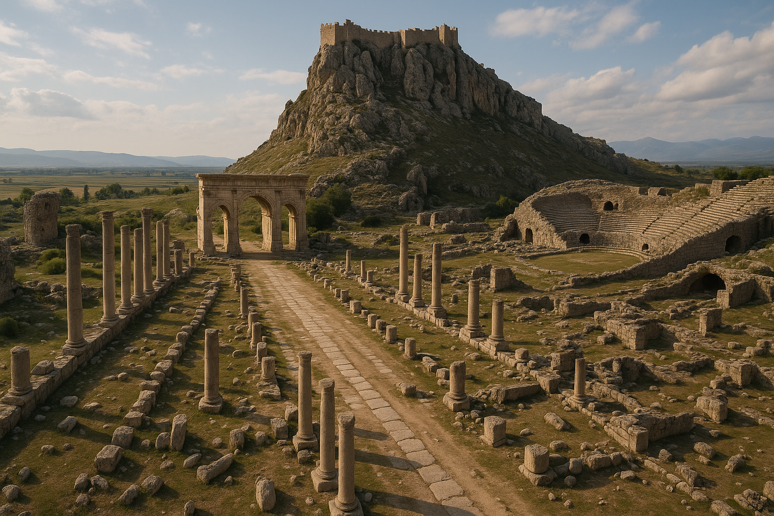
Kastabala, znana w starożytności jako Hierapolis („Święte Miasto") lub Hierapolis ad Pyramum (Hierapolis nad rzeką Pyramos), jest jednym z najważniejszych starożytnych miast Cylicji, położonym w pobliżu rzeki Ceyhan (antyczny Pyramos) w prowincji Osmaniye w południowo-wschodniej Turcji. Historia miasta sięga około 2 700 lat wstecz do okresu późnohityckiego, a najlepiej zachowane pozostałości pochodzą z epoki rzymskiej i bizantyjskiej. Kastabala wyróżnia się spektakularną 300-metrową ulicą kolumnową, teatrem na 5 000 miejsc oraz niezwykłym kultem Artemidy Perazji -- bogini, której kapłanki miały chodzić boso po żarzących się węglach podczas rytuałów. Systematyczne wykopaliska prowadzone przez docenta Farisa Demira z Uniwersytetu Osmaniye Korkut Ata trwają od 2009 roku, ujawniając maski teatralne, obszary kultowe i nowe dowody bogatego życia religijnego i obywatelskiego miasta.
Spis treści
- Dlaczego Kastabala jest ważna
- Geografia i położenie
- Oś czasu historycznej
- Kult Artemidy Perazji
- Główne zabytki
- Prace archeologiczne
- Informacje dla odwiedzających
- Często zadawane pytania
- Źródła i literatura uzupełniająca
Dlaczego Kastabala jest ważna
Kastabala jest niezwykła z kilku powodów, które wyróżniają ją spośród innych starożytnych miast Anatolii:
-
Miasto prawdziwie wielookresowe. Niewiele stanowisk w Turcji oferuje tak wyraźną sekwencję od późnohityckiego pochodzenia przez fazy hellenistyczną, rzymską, bizantyjską aż po średniowieczną krzyżowców. Każdy okres pozostawił istotne świadectwa architektoniczne, czyniąc Kastabalę podręcznikowym przykładem anatolijskiej ciągłości miejskiej.
-
Kult Artemidy Perazji i chodzenie po ogniu. Najbardziej charakterystyczną cechą kulturową Kastabali był kult Artemidy Perazji, bogini unikalnej dla tego regionu. Starożytne źródła opisują kapłanki chodzące boso po gorących węglach w ramach rytualnych obowiązków -- praktykę praktycznie niespotykaną w świecie klasycznym. Ten kult sprawia, że Kastabala jest wyjątkowo istotnym miejscem dla badań nad starożytną religią.
-
Jedna z najpiękniejszych ulic kolumnowych Cylicji. Licząca około 300 metrów ulica kolumnowa biegnąca ze wschodu na zachód przez centrum miasta jest jednym z najlepiej zachowanych przykładów rzymskiego planowania miejskiego we wschodniej Cylicji. Ta monumentalna arteria stanowiła obywatelski kręgosłup miasta.
-
Strategiczne położenie nad rzeką Pyramos. Usytuowanie Kastabali w pobliżu rzeki Ceyhan (antyczny Pyramos) dawało jej kontrolę nad ważnym szlakiem handlowym i wojskowym łączącym wybrzeże Cylicji z płaskowyżem anatolijskim. Ta przewaga strategiczna zapewniała miastu znaczenie w kolejnych epokach.
-
Aktywne i owocne wykopaliska. Od 2009 roku trwające prace wykopaliskowe przyniosły niezwykłe odkrycia, w tym rzymskie maski teatralne, obszar kultu na otwartym powietrzu oraz dowody na rolę miasta jako regionalnego centrum religijnego. Co sezon wykopaliska dostarczają nowych odkryć.
Geografia i położenie
Kastabala leży w dolinie rzeki Ceyhan w prowincji Osmaniye, około 12 kilometrów na północ od centrum miasta Osmaniye. Stanowisko zajmuje pozycję z widokiem na małą żyzną równinę, gdzie dolina rzeki rozszerza się.
| Cecha | Szczegóły |
|---|---|
| Region starożytny | Cylicja Pedias (Cylicja Płaska) |
| Współczesna lokalizacja | W pobliżu wsi Bodrum, dystrykt Osmaniye, prowincja Osmaniye |
| Rzeka | Ceyhan (antyczny Pyramos) |
| Rzeźba terenu | Dolina rzeczna z ufortyfikowanym wzgórzem (zamek) i płaskim centrum miejskim |
| Najbliższe miasto | Osmaniye (~12 km na południe) |
| Najbliższe duże miasto | Adana (~90 km na zachód) |
| Klimat | Śródziemnomorski przejściowy; gorące lata, łagodne zimy |
Rzeka Ceyhan (Pyramos) była jednym z najważniejszych cieków wodnych starożytnej Cylicji. Dostarczała wody do nawadniania, służyła jako szlak transportowy i definiowała strategiczną geografię regionu. Usytuowanie Kastabali wzdłuż tej rzeki dawało jej dostęp zarówno do bogactwa rolniczego równiny Cylicji, jak i do szlaków handlowych łączących Mezopotamię, Lewant i płaskowyż anatolijski.
Miasto zorganizowane jest wokół dwóch głównych elementów topograficznych: płaskiego centrum miejskiego, gdzie znajdują się ulica kolumnowa, teatr i łaźnie, oraz ufortyfikowanego wzgórza na północy zwieńczonego średniowiecznym zamkiem wykorzystującym wcześniejsze mury obronne. Ten podwójny układ -- dolne miasto obywatelskie i górna ufortyfikowana akropola -- jest typowym wzorcem anatolijskich miast, które przeżywały kolejne okresy niepewności.
Oś czasu historycznej
Okres późnohitycki (ok. X--VII w. p.n.e.)
Historia Kastabali zaczyna się w późnohityckim (nowohityckim) okresie, kiedy była częścią sieci małych królestw, które wyrosły z Imperium Hetyckiego w południowo-wschodniej Anatolii i północnej Syrii. Dokładna natura późnohityckiego osiedla w Kastabali nie jest w pełni poznana, ponieważ większość widocznych pozostałości pochodzi z późniejszych epok, lecz tradycje religijne miasta -- w szczególności kult lokalnej bogini -- mogą mieć korzenie w tej epoce.
Okresy asyryjski i perski (VII--IV w. p.n.e.)
Region znalazł się pod wpływem asyryjskim w VII w. p.n.e., a następnie pod kontrolą perską (achemenidyjską). W okresie perskim Cylicja była rządzona przez miejscowych dynastów (linia Syennesis), którzy zachowywali pewien stopień autonomii pod zwierzchnością perską. Kastabala funkcjonowała prawdopodobnie jako centrum religijne w tym okresie, z kultem lokalnej bogini już ugruntowanym.
Okres hellenistyczny (III--I w. p.n.e.)
Po podboju Imperium Perskiego przez Aleksandra Wielkiego Cylicja stała się częścią państwa Seleucydów. W okresie hellenistycznym Kastabala otrzymała tytuł Hierapolis („Święte Miasto") lub Hieropolis, odzwierciedlający znaczenie jej instytucji religijnych. Miasto było niekiedy zwane Hierapolis ad Pyramum, aby odróżnić je od innych miast o tej samej nazwie (zwłaszcza Hierapolis we Frygii, dzisiejszego Pamukkale).
Określenie „Hierapolis" nawiązywało bezpośrednio do świętego okręgu Artemidy Perazji, której kult był definiującą cechą tożsamości miasta.
Okres rzymski (I w. p.n.e. -- IV w. n.e.)
Pod rządami Rzymu Kastabala weszła w najbardziej prosperującą fazę. Rzymianie zainwestowali znacznie w infrastrukturę miasta:
- Wybudowano ulicę kolumnową (około 300 metrów długości, 11 metrów szerokości)
- Wzniesiono teatr (pojemność około 5 000 miejsc)
- Założono kompleksy łaźni
- Miasto otrzymało pełne wyposażenie rzymskiego życia obywatelskiego: budynki publiczne, systemy zaopatrzenia w wodę i architekturę monumentalną
Kastabala z epoki rzymskiej była ważnym regionalnym centrum w prowincji Cylicja, korzystającym z położenia na szlaku handlowym wzdłuż Pyromosu i z trwałej sławy swego sanktuarium religijnego.
Okres bizantyjski (IV--VII w. n.e.)
W epoce bizantyjskiej Kastabala uległa chrystianizacji i w mieście wzniesiono kilka kościołów. Kult Artemidy Perazji został stłumiony, lecz miasto zachowało swoje znaczenie administracyjne. Do wzgórza dodano umocnienia bizantyjskie, rozbudowując wcześniejsze dzieła obronne.
Okres średniowieczny: Krzyżowcy i Ormiańskie Królestwo Cylicji (XI--XIV w.)
W średniowieczu twierdza na wzgórzu została umocniona przez Krzyżowców i później używana przez Ormiańskie Królestwo Cylicji (Cylicję Ormiańską). Zamek dominujący nad sylwetą stanowiska pochodzi głównie z tego okresu, choć zawiera wcześniejszy materiał kamienny. Strategiczne położenie zamku z widokiem na dolinę Ceyhanu czyniło go cennym atutem militarnym podczas burzliwych wieków średniowiecza.
Okres osmański i opuszczenie
Pod rządami Imperium Osmańskiego stanowisko stopniowo traciło funkcję miejską. Ludność przeniosła się do pobliskich osiedli, a starożytne miasto było stopniowo opuszczane, a jego kamienie pozyskiwano na nowe budownictwo.
Kult Artemidy Perazji
Najbardziej niezwykłym aspektem życia religijnego Kastabali był kult Artemidy Perazji (zwanej też Artemidą z Perazji), bogini czczonej prawie wyłącznie w tym regionie.
Kim była Artemida Perazja?
Artemida Perazja była lokalną manifestacją greckiej bogini Artemidy, lecz z wyróżniającymi ją cechami, które odróżniały ją od standardowego greckiego bóstwa. Epitet „Perazja" może wywodzić się od nazwy lokalnego miejsca lub od greckiego słowa oznaczającego „przekroczenie" lub „przejście" -- być może nawiązując do rytuału chodzenia po ogniu.
Kult miał prawdopodobnie korzenie przedgreckie w rdzennych tradycjach religijnych Cylicji, sięgające być może epoki hityckiej lub późnohityckiej. Gdy kultura grecka rozprzestrzeniła się po regionie w epoce hellenistycznej, lokalna bogini została utożsamiona z Artemidą -- najczęściej identyfikowaną z anatolijskimi figurami bogini-matki.
Rytuał chodzenia po ogniu
Starożytne źródła literackie opisują niezwykłą praktykę rytualną w Kastabali: kapłanki Artemidy Perazji chodziły boso po żarzących się węglach w ramach swoich świętych obowiązków. Chodzenie po ogniu nie było karą ani próbą, lecz demonstracją boskiej ochrony -- zdolność kapłanek do przechodzenia przez ogień bez szkody była dowodem mocy bogini i ich własnego świętego statusu.
Praktyka ta jest praktycznie unikalna w świecie klasycznym. Choć ogień miał znaczenie rytualne w wielu starożytnych religiach, konkretna praktyka chodzenia po ogniu przez kapłanki świątynne nie jest udokumentowana w żadnym innym ważnym greckim lub rzymskim sanktuarium. Ta wyjątkowość sprawia, że Kastabala jest miejscem o wyjątkowym znaczeniu dla badań nad starożytną praktyką religijną.
Obszar kultu na otwartym powietrzu
Niedawne wykopaliska odsłoniły obszar kultu na otwartym powietrzu w Kastabali, dostarczając fizycznych dowodów na czynności rytualne opisane w starożytnych źródłach. Odkrycie to jest istotne, gdyż potwierdza, że praktyki religijne w Kastabali obejmowały otwarte przestrzenie ceremonialne -- spójne z rytuałem chodzenia po ogniu, który wymagałby otwartego terenu.
Główne zabytki
Ulica kolumnowa
Ulica kolumnowa jest wizualnym i funkcjonalnym centrum rzymskiej Kastabali.
- Długość: Około 300 metrów (niektóre źródła wskazują 200 metrów dobrze zachowanego odcinka)
- Szerokość: Około 11 metrów (łącznie z kolumnowymi portykami po obu stronach)
- Orientacja: Ze wschodu na zachód, tworząc główną oś miasta
- Kolumny: Pierwotnie oflankowana kolumnami po obu stronach, podtrzymującymi kryte chodniki (portyki) chroniące sklepy, warsztaty i urzędy publiczne
- Data: Okres rzymski (I--II w. n.e.)
- Stan obecny: Wiele baz kolumn zachowanych in situ; część kolumn została ponownie ustawiona podczas prac konserwatorskich; nawierzchnia ulicy jest częściowo zachowana
Ulica kolumnowa była obywatelskim kręgosłupem miasta -- główną arterią dla handlu, procesji i codziennego życia. W rzymskim planowaniu miejskim takie ulice (znane jako plateia lub cardo/decumanus) były standardowymi elementami zamożnych miast. Skala ulicy kolumnowej Kastabali -- należącej do największych we wschodniej Cylicji -- odzwierciedla bogactwo i znaczenie miasta.
Niedawne prace restauracyjne zmierzają do ponownego ustawienia kolejnych kolumn i odtworzenia fragmentów ulicy, aby dać odwiedzającym lepsze wyobrażenie o jej pierwotnej świetności.
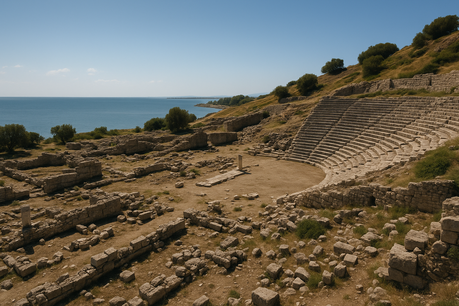
Teatr
Teatr w Kastabali jest jednym z najważniejszych teatrów rzymskich w Cylicji.
- Pojemność: Około 5 000 widzów
- Data: Wzniesiony w trakcie I w. n.e. pod wpływem cesarstwa rzymskiego
- Lokalizacja: Wbudowany w naturalne zbocze na południowym krańcu miasta
- Budowla: Półkoliste cavea (miejsca dla publiczności), orchestra i budynek sceny (scaenae frons)
- Maski teatralne: Wykopaliska odsłoniły pięć reliefów z maskami teatralnymi z epoki rzymskiej wyrzeźbionych w kamieniu teatru, w tym rzadkie przedstawienie starszego filozofa -- niezwykłe znalezisko sugerujące, że teatr gościł zarówno spektakle intelektualne, jak i dramatyczne
- Zachowanie: Cavea jest częściowo zachowana; budynek sceny jest w dużej mierze zrujnowany, lecz zachowuje wystarczająco elementów, by zrekonstruować jego pierwotną formę
Maski teatralne odkryte w Kastabali należą do najważniejszych niedawnych znalezisk w archeologii Cylicji. W tradycji rzymskiego teatru maski przedstawiały typowe postacie: młodego kochanka, starca, niewolnika, żołnierza i inne. Maska filozofa znaleziona w Kastabali jest szczególnie rzadka, gdyż sugeruje, że przedstawienia w tym teatrze mogły obejmować dialogi filozoficzne lub wykłady obok konwencjonalnego dramatu i komedii.
Zamek (twierdza średniowieczna)
Zamek wieńczący wzgórze na północ od centrum miasta jest najbardziej dramatycznym wizualnie elementem stanowiska.
- Data: Przede wszystkim średniowieczna (XI--XIV w. n.e.), z wcześniejszymi fundamentami
- Budowniczowie: Używany przez Krzyżowców i Ormiańskie Królestwo Cylicji
- Lokalizacja: Na stromym wzgórzu z widokiem na ulicę kolumnową i dolinę Ceyhanu
- Budowla: Mury obronne, wieże i komnaty wewnętrzne zbudowane z obrobionych kamieni, w dużej mierze wtórnie wykorzystanych z budynków z epoki rzymskiej
- Widoki: Zamek oferuje rozległą panoramę doliny rzeki Ceyhan i otaczającej równiny rolniczej
Zamek dowodzi strategicznego znaczenia tej lokalizacji w kolejnych epokach historycznych. Wzgórze było prawdopodobnie ufortyfikowane od najwcześniejszego osadnictwa, a każda kolejna kultura -- hetycka, hellenistyczna, rzymska, bizantyjska, krzyżowców, ormiańska -- rozbudowywała lub przebudowywała umocnienia.
Łaźnie rzymskie
Kompleksy łaźni (thermae) były niezbędnymi elementami rzymskiego życia obywatelskiego, a Kastabala posiada pozostałości co najmniej jednego okazałego budynku łaźni.
- Wyposażenie: Hypocaustum (ogrzewanie podłogowe), gorące komnaty (caldarium), ciepłe komnaty (tepidarium) i zimne komnaty (frigidarium)
- Data: Okres rzymski (I--III w. n.e.)
- Zachowanie: Częściowe; mury i infrastruktura grzewcza przetrwały
Kościoły bizantyjskie
Na terenie miasta zidentyfikowano kilka ruin kościołów z okresu bizantyjskiego.
- Typ: Kościoły na planie bazyliki z apsydami
- Data: V--VII w. n.e.
- Znaczenie: Kościoły oznaczają przejście od pogańskiej Kastabali (z kultem Artemidy Perazji) do Kastabali chrześcijańskiej
- Niektóre kościoły wzniesiono bezpośrednio na wcześniejszych pogańskich miejscach kultu lub w ich pobliżu, co odzwierciedla powszechną chrześcijańską praktykę uświęcania wcześniej świętych miejsc
Obszar kultu na otwartym powietrzu
Niedawno odkryty obszar kultu na otwartym powietrzu dostarcza bezpośrednich dowodów na praktyki rytualne, które uczyniły Kastabalę sławną w starożytności.
- Odkrycie: Znalezione podczas ostatnich sezonów wykopaliskowych
- Cechy: Otwarty okręg ze śladami aktywności rytualnej, w tym spalenymi obszarami, które mogą być związane z ceremonią chodzenia po ogniu
- Znaczenie: Jest to jedno z nielicznych fizycznych potwierdzeń praktyk kultowych opisanych w starożytnych źródłach literackich
Nekropola i sarkofagi
Nekropola Kastabali obejmuje sarkofagi i groby murowane z okresu rzymskiego i bizantyjskiego, usytuowane poza murami miasta zgodnie ze standardową praktyką starożytną.
- Sarkofagi: Ozdobne kamienne sarkofagi z reliefami
- Typy grobów: Groby wykute w skale, murowane groby komorowe i wolnostojące sarkofagi
- Inskrypcje: Niektóre groby noszą inskrypcje podające imiona i szczegóły biograficzne
Prace archeologiczne
Wczesne eksploracje
Kastabala była znana europejskim podróżnikom i badaczom od XIX wieku. Wczesni odwiedzający dokumentowali ulicę kolumnową i zamek, lecz żadne systematyczne wykopaliska nie były prowadzone aż do XXI wieku.
Systematyczne wykopaliska (2009 -- do dziś)
Pierwsze legalne, systematyczne wykopaliska w Kastabali rozpoczęły się w 2009 roku, prowadzone przez docenta Farisa Demira z Wydziału Archeologii Uniwersytetu Osmaniye Korkut Ata (OKU). Wykopaliska są wspólnym projektem Prowincjonalnej Dyrekcji Kultury i Turystyki w Osmaniye oraz uczelni.
Kluczowe osiągnięcia trwających wykopalisk obejmują:
- Odsłonięcie i szczegółowe udokumentowanie ulicy kolumnowej
- Wykopanie teatru i odkrycie pięciu reliefów z maskami teatralnymi z epoki rzymskiej, w tym rzadkiej maski starszego filozofa
- Identyfikację obszaru kultu na otwartym powietrzu związanego z kultem Artemidy Perazji
- Udokumentowanie pozostałości kościołów bizantyjskich
- Prowadzenie badań i kartowanie zamku wraz z jego wieloma fazami budowlanymi
- Prace konserwatorskie zmierzające do stabilizacji murów i ponownego ustawienia powalonych kolumn
Wykopaliska trwają corocznie, a każdy sezon przynosi nowe odkrycia pogłębiające rozumienie tego wielookresowego miasta. Potencjał archeologiczny stanowiska jest ogromny: rozległe obszary miasta pozostają niewyeksplorowane, a przyszłe prace mają ujawnić dodatkowe budynki publiczne, dzielnice mieszkalne i dowody osadnictwa z epoki hetyckiej.
Informacje dla odwiedzających
Jak dotrzeć
- Z Osmaniye: Jedź na północ około 12 km. Stanowisko jest oznakowane w pobliżu wsi Bodrum.
- Z Adany: Jedź autostradą O-21 na wschód do Osmaniye (~90 km), następnie podążaj lokalnymi drogami na północ do stanowiska.
- Z Gaziantep: Jedź autostradą O-52 na zachód w kierunku Osmaniye (~200 km).
- Współrzędne GPS: Około 37.15N, 36.25E (sprawdź lokalnie)
Czego się spodziewać
- Opłata wstępu: Niewielka opłata za wstęp (sprawdź aktualne stawki w dyrekcji muzeum w Osmaniye)
- Zaplecze: Podstawowe zaplecze; mała strefa dla odwiedzających przy wejściu
- Teren: Dolne miasto (ulica kolumnowa, teatr, łaźnie) leży na stosunkowo płaskim terenie. Zamek wymaga stromego podejścia pod górę.
- Oznakowanie: Tablice informacyjne przy głównych obiektach
Zalecany czas wizyty
- Tylko dolne miasto (ulica kolumnowa, teatr): 1--1,5 godziny
- Z wejściem na zamek: 2--3 godziny
- Szczegółowa wizyta z fotografowaniem: Pół dnia
Najlepszy czas na wizytę
- Wiosna (marzec--maj): Najprzyjemniejsza pogoda; zielony krajobraz
- Jesień (wrzesień--listopad): Komfortowe temperatury, dobra widoczność
- Lato: Gorąco (Osmaniye może przekraczać 40°C); odwiedzaj wczesnym rankiem lub późnym popołudniem
- Zima: Łagodna, lecz możliwe opady deszczu; ścieżki na zamku mogą być śliskie
Połączone wizyty
Kastabala dobrze łączy się z:
- Karatepe-Aslantaş Muzeum na Wolnym Powietrzu -- późnohitycka twierdza z dwujęzycznymi inskrypcjami (~60 km na północ), jedno z najważniejszych stanowisk nowohityckich w Turcji
- Muzeum Archeologicznym w Osmaniye -- gromadzi znaleziska z Kastabali i innych regionalnych stanowisk
- Toprakkale (zamek cylicyjsko-ormiański) -- imponująca twierdza średniowieczna (~15 km na południe)
- Yılan Kalesi (Zamek Węża) -- zamek z epoki krzyżowców nad rzeką Ceyhan (~40 km na zachód)
- Zamek w Kozan -- masywna twierdza ormiańska (~70 km na północny zachód)
Wskazówki
- Zacznij od ulicy kolumnowej, następnie odwiedź teatr, a zakończ wejściem na zamek z widokiem panoramicznym
- Zabierz wodę, zwłaszcza na wejście na zamek w ciepłą pogodę
- Stanowisko jest stosunkowo kompaktowe, co czyni je dostępnym nawet dla odwiedzających z ograniczonym czasem
- Zapytaj w muzeum w Osmaniye o najnowsze informacje z wykopalisk, ponieważ nowe obszary mogą być dostępne dla odwiedzających
- Fotografowanie jest doskonałe z zamku, skąd widać ulicę kolumnową rozciągającą się poniżej
Często zadawane pytania
Dlaczego Kastabala jest też nazywana Hierapolis?
Nazwa Hierapolis (greckie „Święte Miasto") została nadana Kastabali ze względu na wybitne sanktuarium Artemidy Perazji, które definiowało tożsamość miasta. Była też zwana Hierapolis ad Pyramum („Święte Miasto nad Pyramosem"), aby odróżnić ją od słynniejszej Hierapolis we Frygii (dzisiejszego Pamukkale).
Czym był rytuał chodzenia po ogniu?
Starożytne źródła opisują kapłanki Artemidy Perazji chodzące boso po żarzących się węglach w ramach swych obowiązków religijnych. Nie była to kara, lecz demonstracja boskiej łaski -- ich zdolność do przechodzenia przez ogień bez szkody dowodziła mocy bogini. Praktyka ta jest praktycznie unikalna w świecie starożytnym i sprawia, że Kastabala jest wyjątkowo ważna dla badań nad starożytną religią.
Jak stara jest Kastabala?
Historia miasta sięga około 2 700 lat wstecz do okresu późnohityckiego (ok. X--VII w. p.n.e.). Jednak najlepiej widoczne ruiny pochodzą z okresu rzymskiego (I--III w. n.e.) i średniowiecza (XI--XIV w. n.e.).
Jakie są maski teatralne znalezione w teatrze?
Wykopaliska odsłoniły pięć reliefów z maskami teatralnymi z epoki rzymskiej wyrzeźbionych w kamieniu teatru. Obejmują one maski konwencjonalne (młody kochanek, starzec, niewolnik) i rzadkie przedstawienie starszego filozofa. Maska filozofa sugeruje, że teatr w Kastabali mógł gościć przedstawienia intelektualne obok konwencjonalnego dramatu.
Czy wejście na zamek jest warte wysiłku?
Zdecydowanie tak. Wejście zajmuje około 15--20 minut z dolnego miasta i wynagradza odwiedzających panoramicznymi widokami na dolinę rzeki Ceyhan, ulicę kolumnową poniżej i otaczającą równinę rolniczą. Sam zamek jest imponujący, z murami i wieżami z okresu krzyżowców i ormiańskiego.
Czy to ta sama Hierapolis co Pamukkale?
Nie. Hierapolis w Pamukkale leży we Frygii (prowincja Denizli, zachodnia Turcja) i jest słynna z trawertynowych tarasów i gorących źródeł. Hierapolis Kastabali leży w Cylicji (prowincja Osmaniye, południowo-wschodnia Turcja) i jest słynna z kultu Artemidy Perazji i ulicy kolumnowej. Wspólna nazwa „Hierapolis" oznacza po prostu „Święte Miasto" i była używana dla kilku starożytnych miast.
Wymiary architektoniczne i dane strukturalne
Systematyczne wykopaliska od 2009 roku dostarczyły precyzyjnych pomiarów głównych zabytków Kastabali. Poniższa tabela zestawia zweryfikowane wymiary z opublikowanych raportów.
| Zabytek | Wymiary / Kluczowy pomiar | Data |
|---|---|---|
| Ulica kolumnowa -- całkowita długość | Ok. 300 m | Rzymska, I--II w. n.e. |
| Ulica kolumnowa -- szerokość (łącznie z portykami) | Ok. 11 m | Rzymska |
| Teatr -- pojemność miejsc | Ok. 5 000 widzów | I w. n.e. |
| Teatr -- zachowane rzędy siedzeń | 15 rzędów zachowanych po wschodniej stronie | I w. n.e. |
| Zamek -- główna faza budowlana | XI--XIV w. n.e. (Krzyżowcy / Ormianie) | Średniowieczna |
| Łaźnie rzymskie -- system ogrzewania | Hypocaustum z caldarium, tepidarium, frigidarium | I--III w. n.e. |
| Kościoły bizantyjskie | Plan bazyliki z apsydami | V--VII w. n.e. |
Teatr usytuowany jest po wschodniej stronie miasta, wbudowany w naturalne zbocze. Choć 15 rzędów siedzeń przetrwało in situ, pierwotna budowla zawierała prawdopodobnie dodatkowe rzędy powyżej, co daje łączną pojemność około 5 000 miejsc. Pięć reliefów z maskami teatralnymi z epoki rzymskiej wyrzeźbiono bezpośrednio w kamieniu teatru -- stosunkowo rzadka technika dekoracyjna, ponieważ większość masek teatralnych w rzymskiej Azji Mniejszej była wolnostojącymi elementami rzeźbiarskimi, a nie reliefami zintegrowanymi ze ścianą.
Dowody numizmatyczne i dynastia Tarkondimotos
Monety Kastabali dostarczają bezpośrednich dowodów na historię polityczną miasta, w szczególności na okres półniezależnych rządów pod dynastią Tarkondimotos.
| Okres | Typ monety | Charakterystyczne cechy |
|---|---|---|
| II--I w. p.n.e. | Brąz miejski Hieropolis-Kastabala | Wieżyczkowe popiersie Tyche (awers); siedząca bogini (rewers) |
| 52--31 p.n.e. | Monety dynastyczne Tarkondimotos I | Portret króla z diademem (awers); Zeus siedzący, trzymający Nike i berło (rewers) |
| 31 p.n.e.--17 n.e. | Emisje Tarkondimotos II | Kontynuacja pod patronatem Augusta |
| Cesarstwo Rzymskie | Brąz prowincjonalny | Standardowe typy miejskie römskie |
Tarkondimotos I ustanowił niezależne księstwo ze stolicą w Kastabali między 52 a 31 r. p.n.e., bijąc monety przedstawiające go w królewskim diademie -- wyraźne roszczenie do suwerenności. Po śmierci Tarkondimotos I w walce u boku Marka Antoniusza podczas bitwy pod Akcjum (31 r. p.n.e.) August przywrócił dynastię, uznając Tarkondimotos II za króla-klienta. Dowody numizmatyczne świadczą o płynnym przejściu od monet dynastycznych do prowincjonalnych, dokumentując integrację Kastabali w ramach cesarstwa rzymskiego.
Chronologia wykopalisk i kluczowe kampanie
| Rok(y) | Kierownik / Zespół | Kluczowe działania i odkrycia |
|---|---|---|
| 1890 | J. Theodore Bent (brytyjski podróżnik) | Pierwsze rozpoznanie ruin na podstawie inskrypcji |
| XIX--XX w. | Różni europejscy podróżnicy | Dokumentacja ulicy kolumnowej i zamku; brak systematycznych wykopalisk |
| 2009 | Turgut Hacı Zeyrek / Osmaniye Korkut Ata University | Rozpoczęcie pierwszych systematycznych legalnych wykopalisk |
| 2009--do dziś | Faris Demir / OKU (późniejsze kampanie) | Szczegółowe udokumentowanie ulicy kolumnowej |
| Ostatnie sezony | Faris Demir / OKU | Odsłonięcie pięciu reliefów z maskami teatralnymi, w tym rzadkiej maski starszego filozofa |
| Ostatnie sezony | Faris Demir / OKU | Identyfikacja obszaru kultu na otwartym powietrzu ze śladami spalonych powierzchni |
| Ostatnie sezony | Faris Demir / OKU | Udokumentowanie pozostałości kościołów bizantyjskich; inwentaryzacja zamku i kartowanie wielofazowe |
| Trwające | OKU / Prowincjonalna Dyrekcja w Osmaniye | Ponowne ustawianie kolumn i prace konserwatorskie wzdłuż ulicy kolumnowej |
Odkrycie obszaru kultu na otwartym powietrzu stanowi jedno z najbardziej znaczących potwierdzenia archeologicznych w studiach cylicyjskich. Starożytne źródła literackie -- w szczególności Strabon (Geografia XII.2.7) -- opisywały rytuał chodzenia po ogniu kapłanek Artemidy Perazji, lecz aż do momentu gdy wykopaliska ujawniły spalone powierzchnie i szczątki rytualne w otwartym okręgu, brakowało fizycznych dowodów. Korelacja między opisem literackim a zapisem archeologicznym wzmacnia identyfikację Kastabali jako ważnego regionalnego centrum kultowego.
Inskrypcje i tożsamość obywatelska
Opublikowane inskrypcje z Kastabali-Hierapolis dostarczają dowodów na instytucje obywatelskie i tożsamość kulturową miasta przez kilka stuleci. Imiona osobowe odnotowane w inskrypcjach -- takie jak Nikolaos i Theodoros -- odzwierciedlają zhellenizowane konwencje nazewnicze wschodniej Cylicji, podczas gdy inskrypcje honoryfikacyjne dokumentują znaczenie rodowodu i cnót osobistych w lokalnej kulturze politycznej.
Sama podwójna nomenklatura miasta jest epigraficznie potwierdzona: inskrypcje używają zarówno „Kastabala" (rdzennego toponimu, prawdopodobnie pochodzenia luwijskiego), jak i „Hierapolis" (greckiego oznaczenia honoryfikacyjnego oznaczającego „Święte Miasto"), niekiedy w tym samym tekście. Ten dwujęzyczny wzorzec nazewniczy ilustruje warstwowanie kulturowe charakterystyczne dla miast cylicyjskich, w których tożsamości przedgrecka, grecka i rzymska współistniały.
Określenie „Hierapolis" było specjalnie powiązane z sanktuarium Artemidy Perazji, której kult definiował święty status miasta i uzasadniał prestiżowy tytuł. Badanie Uniwersytetu Cambridge dotyczące Tarkondimotos i hellenizmu obywatelskiego w Hierapolis-Kastabali pokazuje, jak miejscowa dynastia strategicznie przyjęła greckie formy obywatelskie -- w tym wyobrażenia na monetach, architekturę świątynną i organizację festiwali -- aby legitymizować swoją władzę w ramach zhellenizowanego układu politycznego.
Źródła i literatura uzupełniająca
- Castabala -- Wikipedia
- Castabala-Hierapolis -- Turkish Archaeological News
- Stanowisko archeologiczne Kastabala -- Turkish Museums
- Odkrycie masek teatralnych -- Arkeonews
- Restauracja ulicy kolumnowej -- Arkeonews
- Obszar kultu na otwartym powietrzu -- Anatolian Archaeology
- Kastabala Hierapolis -- Invest in Osmaniye
- Prowincjonalna Dyrekcja Kultury i Turystyki w Osmaniye
Rzeka Pyramos: Arteria życia starożytnej Cylicji
Rzeka Ceyhan (antyczny Pyramos) jest jedną z najważniejszych rzek w południowo-wschodniej Turcji, a cała historia Kastabali jest nierozerwalnie związana z tym ciekiem wodnym. Zrozumienie rzeki pomaga odwiedzającym docenić, dlaczego miasto rozwinęło się właśnie tutaj i dlaczego pozostawało ważne przez tysiąclecia.
Znaczenie geograficzne
Pyramos ma długość około 509 km, bierze początek w górach Anty-Taurusu i płynie na południe przez Cylicję, by dotrzeć do Morza Śródziemnego. W starożytności był jedną z głównych rzek Azji Mniejszej, porównywalną w znaczeniu do systemów Tygrysu i Eufratu definiujących Mezopotamię.
Rzeka pełniła wiele funkcji dla Kastabali:
- Nawadnianie rolnicze -- żyzna równina aluwialna wzdłuż rzeki wspierała intensywne rolnictwo, produkując zboże, oliwki, winogrona i inne uprawy
- Szlak transportowy -- towary mogły być przewożone rzeką między wnętrzem lądu a wybrzeżem
- Zaopatrzenie w słodką wodę -- niezbędne dla dużej populacji miejskiej i jej kompleksów łaźni
- Ochronna fosa -- rzeka stanowiła naturalną barierę przed atakiem z pewnych kierunków
- Znaczenie symboliczne -- Pyramos sam w sobie był przedmiotem mitologii i kultu
Pyramos w mitologii
Rzeka Pyramos dała nazwę jednej z najbardziej znanych tragicznych historii miłosnych świata starożytnego: Pyramos i Tyzbe, później opowiedzianej przez Owidiusza w jego Metamorfozach. Choć historia jest zazwyczaj kojarzona z Babilonem, nazwa rzeki łączy ją z krajobrazem Cylicji, a niektóre starożytne tradycje umieszczały wydarzenia w pobliżu doliny Pyromosu.
Ulice kolumnowe w rzymskiej Anatolii: spojrzenie porównawcze
Ulica kolumnowa Kastabali wpisuje się w tradycję monumentalnych arterii miejskich, która była jedną z definiujących cech miast rzymskich we wschodnim Morzu Śródziemnym. Zrozumienie tej tradycji pomaga odwiedzającym docenić to, co widzą.
Koncepcja
Rzymska ulica kolumnowa składała się z:
- Centralnej brukowanej jezdni wystarczająco szerokiej dla ruchu pojazdów
- Krytych portyków (kolumnad) po obu stronach, zapewniających cień i schronienie
- Sklepów i warsztatów otwierających się na portyki
- Kanałów wodnych biegnących wzdłuż lub pod nawierzchnią
- Monumentalnych bram lub łuków wyznaczających krańce ulicy
Ulice te nie były jedynie funkcjonalnymi arteriami; były alejami ceremonialnnymi zaprojektowanymi, by imponować przybyszom, gościć procesje i demonstrować bogactwo i rzymską tożsamość miasta.
Porównywalne ulice w Cylicji i poza nią
| Miasto | Długość ulicy kolumnowej | Prowincja |
|---|---|---|
| Kastabala | ~300 m | Cylicja |
| Anazarbos | ~1 700 m | Cylicja |
| Tars | Nieznana (częściowo zbadana) | Cylicja |
| Perge | ~250 m | Pamfilia |
| Side | ~200 m | Pamfilia |
| Apamea (Syria) | ~1 850 m | Syria |
| Palmyra (Syria) | ~1 100 m | Syria |
Ulica kolumnowa Kastabali, choć nie jest najdłuższa, należy do najlepiej zachowanych w Cylicji i stanowi doskonały przykład tej charakterystycznie rzymskiej cechy urbanistycznej.