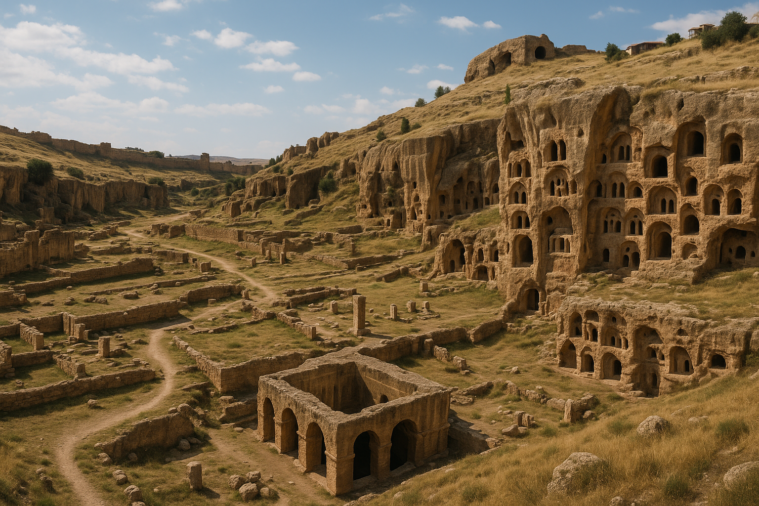
Tushpa, ancienne capitale du Royaume d'Urartu, est l'un des sites archéologiques les plus importants de l'est de la Turquie. Bâtie au sommet d'un imposant affleurement rocheux de conglomérat s'élevant à 100 mètres au-dessus de la rive sud du lac de Van, la forteresse servit de cœur politique, militaire et cérémoniel de l'Urartu depuis le milieu du IXe siècle av. J.-C. jusqu'à la chute du royaume vers 585 av. J.-C.. Le rocher de Van -- 1 345 mètres de long et 70 à 80 mètres de large -- conserve des tombeaux royaux rupestres, la célèbre Inscription trilingue de Xerxès, la monumentale Tour de Sarduri et plus de 4 000 inscriptions cunéiformes qui constituent la source la plus riche à elle seule pour reconstituer l'histoire urartéenne.
Table des matières
- Pourquoi Tushpa compte
- Géographie et cadre
- Chronologie historique
- Monuments majeurs
- Travaux archéologiques
- Informations pour les visiteurs
- Foire aux questions
- Sources et lectures complémentaires
Pourquoi Tushpa compte
-
Capitale d'un empire disparu. L'Urartu (connu sous le nom de Royaume de Van dans la tradition locale et de Biainili en langue urartéenne) fut l'un des États les plus puissants du Proche-Orient à l'âge du fer, rivalisant avec l'Assyrie pour le contrôle des Hautes Terres arméniennes, de l'Anatolie orientale et de certaines parties du nord-ouest de l'Iran. Tushpa en était le centre nerveux.
-
Archive inégalée d'inscriptions urartéennes. Avec plus de 4 000 inscriptions sur pierre, stèles, argile et métal, la Forteresse de Van détient la plus grande collection de textes cunéiformes urartéens au monde -- essentielle pour comprendre la langue, la religion, les campagnes militaires et l'administration de cette civilisation encore partiellement mystérieuse.
-
L'Inscription de Xerxès. Une inscription cunéiforme trilingue gravée dans la roche par le roi perse achéménide Xerxès Ier (r. 486-465 av. J.-C.) en vieux-perse, babylonien et élamite. Cette inscription joua un rôle déterminant dans les premiers déchiffrements du cunéiforme vieux-perse et rattache Tushpa à l'histoire plus large de l'épigraphie proche-orientale antique.
-
Tombeaux royaux rupestres extraordinaires. Des tombeaux à plusieurs chambres taillés profondément dans la roche vive -- y compris le tombeau du roi Argishti Ier -- fournissent une rare preuve directe des pratiques funéraires royales urartéennes et des croyances concernant l'au-delà.
-
Une importance continue à travers les millénaires. De capitale urartéenne à avant-poste achéménide, de citadelle islamique médiévale à forteresse ottomane, le Rocher de Van fut un siège du pouvoir pendant près de 3 000 ans, ce qui en fait l'un des sites fortifiés les plus longtemps utilisés au monde.
Géographie et cadre
Tushpa / Forteresse de Van est située dans le district d'Ipekyolu de la province de Van, sur la rive sud du lac de Van -- le plus grand lac de Turquie et le plus grand lac de soude du monde (environ 3 755 kilomètres carrés).
| Caractéristique | Détail |
|---|---|
| Coordonnées | 38,50 N, 43,34 E |
| Dimensions du rocher | ~1 345 m de long, 70-80 m de large, ~100 m de haut |
| Altitude | ~1 750 m au-dessus du niveau de la mer (sommet du rocher) |
| Altitude du lac de Van | ~1 648 m au-dessus du niveau de la mer |
| Ville la plus proche | Van (directement adjacente) |
| Aéroport le plus proche | Aéroport Van Ferit Melen (environ 10 km au sud) |
| Région | Anatolie orientale / Hautes Terres arméniennes |
Le cadre est spectaculaire : la masse rocheuse sombre s'élève abruptement depuis la plaine plate de la rive du lac, avec l'étendue turquoise du lac de Van s'étirant au nord-ouest et les sommets enneigés de l'Erek Dagi (3 200 m) visibles au sud. La combinaison du lac, de la forteresse et de la montagne crée l'un des cadres paysagers les plus saisissants de tous les sites archéologiques de Turquie.
Le climat continental à cette altitude se caractérise par des hivers longs, froids et enneigés (novembre-avril) et des étés chauds et secs. Les eaux alcalines du lac de Van et la haute altitude créent un microclimat unique.
Chronologie historique
Période pré-urartéenne (avant le IXe siècle av. J.-C.)
Le Rocher de Van fut probablement utilisé comme position défensive avant la formation de l'État urartéen. La région autour du lac de Van apparaît dans les annales assyriennes dès le XIIIe siècle av. J.-C. comme le pays de Nairi, une confédération lâche de tribus locales que les Urartéens finirent par unifier.
Fondation de la capitale urartéenne (milieu du IXe siècle av. J.-C.)
Le roi Sarduri Ier (vers 832-820 av. J.-C.), fils de Lutipri, établit une nouvelle dynastie et fit de Tushpa la capitale de l'État urartéen unifié. Ses principales réalisations :
- Résista aux attaques assyriennes venues du sud menées par Salmanazar III, le puissant roi assyrien dont les annales relatent des campagnes contre l'Urartu.
- Consolida le pouvoir militaire et établit Tushpa comme centre administratif et cérémoniel.
- Construisit la Tour de Sarduri (Madır Burcu) à l'extrémité occidentale du rocher -- une imposante structure en pierre utilisant d'énormes blocs, dont certains portent son nom en cunéiforme. L'inscription sur ces blocs se lit ainsi : « Sarduri, fils de Lutipri, le grand roi, le roi puissant, roi de l'univers, roi du pays de Biainili. »
Période d'expansion (820-743 av. J.-C.)
Sous les successeurs de Sarduri Ier, l'Urartu s'étendit considérablement :
- Roi Ispuini (vers 820-810 av. J.-C.) : Co-régna avec son fils Menua ; réorganisa la religion d'État.
- Roi Menua (vers 810-786 av. J.-C.) : Le grand roi bâtisseur. Sa réalisation la plus durable fut le Canal de Menua (Shamram Su), un canal d'irrigation d'environ 72 km de long, 4,5 mètres de large et 1,5 mètre de profondeur, amenant l'eau des montagnes aux vignobles, jardins et champs autour de Tushpa. Remarquablement, ce canal transporte encore de l'eau aujourd'hui, ce qui en fait l'un des plus anciens canaux d'eau encore en fonction au monde.
- Roi Argishti Ier (vers 785-763 av. J.-C.) : Étendit l'empire à sa plus grande extension territoriale, fondant Erebuni (l'actuelle Erevan, Arménie) en 782 av. J.-C. Son tombeau rupestre à Tushpa est l'un des monuments funéraires urartéens les plus importants.
Apogée et rivalité avec l'Assyrie (743-714 av. J.-C.)
- Roi Sarduri II (vers 763-735 av. J.-C.) : Mena des guerres majeures contre l'Assyrie. Défait par Téglath-Phalasar III d'Assyrie en 743 av. J.-C., marquant le début de la contraction territoriale urartéenne.
- Roi Rusa Ier (vers 735-714 av. J.-C.) : Subit une défaite dévastatrice aux mains du roi assyrien Sargon II lors de la campagne de 714 av. J.-C., que Sargon décrivit en détail dans sa célèbre inscription de Khorsabad. Selon la tradition, Rusa se suicida après la défaite.
Déclin et chute (714-585 av. J.-C.)
Après les campagnes assyriennes, l'Urartu déclina progressivement :
- Roi Rusa II (vers 685-645 av. J.-C.) : Une période finale d'ambition architecturale, incluant la construction de Rusahinili (l'actuelle Toprakkale) près de Van et d'Ayanis sur la rive nord du lac de Van.
- À la fin du VIIe siècle av. J.-C., l'Urartu était pris en étau entre les Mèdes en pleine ascension à l'est et les pillards scythes venus du nord.
- En 585 av. J.-C., les Mèdes conquirent Van, mettant fin à la souveraineté urartéenne. La citadelle fut abandonnée, bien que le nom « Tushpa » survécût, transformé en « Thospitis » -- utilisé plus tard pour désigner le lac lui-même (d'où « Van » d'une forme ultérieure).
Période perse achéménide (VIe-IVe siècle av. J.-C.)
Sous l'Empire achéménide, le rocher de Van retrouva son importance. Le roi Xerxès Ier (r. 486-465 av. J.-C.) grava sa célèbre inscription trilingue dans la paroi rocheuse, consignant ses titres et accomplissements en vieux-perse, babylonien et élamite. Cette inscription joua un rôle crucial dans les premiers déchiffrements de l'écriture cunéiforme par des savants tels qu'Eugène Burnouf au XIXe siècle.
Périodes ultérieures (de l'hellénistique à l'ottoman)
Le Rocher de Van continua à servir de forteresse à travers :
- Les périodes hellénistique et parthe
- Les ères romaine et byzantine
- La période islamique médiévale (Arabes, Seldjoukides et diverses dynasties turciques)
- L'Empire ottoman, qui utilisa la forteresse jusqu'au début du XXe siècle
Chaque période ajouta de nouvelles couches de fortification, créant le site complexe à multiples périodes visible aujourd'hui.
Monuments majeurs
La Tour de Sarduri (Madır Burcu)
Située à l'extrémité occidentale du rocher, cette structure monumentale fut construite par le roi Sarduri Ier au milieu du IXe siècle av. J.-C. Elle se compose d'imposants blocs de pierre -- certains pesant plusieurs tonnes -- assemblés sans mortier selon la tradition de la maçonnerie cyclopéenne. Plusieurs blocs portent des inscriptions cunéiformes identifiant Sarduri Ier et proclamant ses titres royaux. La tour servait à la fois de bastion défensif et d'affirmation du pouvoir royal.
Les tombeaux royaux rupestres
De multiples chambres funéraires sont creusées profondément dans le rocher de Van, représentant la nécropole royale des rois urartéens. Caractéristiques clés :
- Conception à plusieurs chambres : Les tombeaux comportent des chambres simples, doubles ou triples taillées dans la roche, reflétant le statut du défunt.
- Entrées scellées : Chaque entrée de tombeau était à l'origine scellée par une imposante dalle de pierre.
- Inscriptions : Plusieurs tombeaux portent des inscriptions décrivant les accomplissements et les campagnes militaires de leurs occupants.
- Tombeau d'Argishti Ier : L'un des plus importants, avec plusieurs chambres et des parois inscrites documentant les conquêtes et les projets de construction du roi.
Les tombeaux fournissent des preuves cruciales des croyances urartéennes sur la mort et l'au-delà, y compris des provisions pour le défunt sous forme de poteries, de vases en métal et d'offrandes alimentaires.
L'Inscription de Xerxès
Gravée dans la paroi rocheuse du côté sud de la forteresse, cette inscription trilingue consigne les titres et revendications du roi achéménide Xerxès Ier en trois langues :
| Langue | Écriture |
|---|---|
| Vieux-perse | Cunéiforme vieux-perse |
| Babylonien | Cunéiforme akkadien |
| Élamite | Cunéiforme élamite |
L'inscription fut cruciale pour les travaux d'Eugène Burnouf et d'autres sur le déchiffrement du cunéiforme vieux-perse dans les années 1830-1840, contribuant à l'une des grandes réalisations intellectuelles de l'érudition du XIXe siècle.
Les Mille Marches (Bin Basamak)
Une série de marches rupestres taillées dans les flancs escarpés du rocher de la forteresse, donnant accès depuis la base jusqu'au sommet de la citadelle. Ces marches, usées par des millénaires d'utilisation, offrent une ascension spectaculaire avec des vues de plus en plus saisissantes sur le lac de Van.
Temples en plein air et niches rituelles
Plusieurs niches et plateformes taillées dans la paroi rocheuse servaient de lieux de culte en plein air pour les cérémonies religieuses urartéennes. La religion d'État urartéenne était centrée sur le dieu Haldi (la divinité suprême), avec Teisheba (dieu de l'orage) et Shivini (dieu du soleil). Des inscriptions rituelles et des plateformes d'offrande sont gravées directement dans la roche exposée.
Le Canal de Menua (Shamram Su)
Bien que non situé directement à la forteresse, le Canal de Menua est indissociable de l'histoire de Tushpa. Construit par le roi Menua (vers 810-786 av. J.-C.), ce canal d'irrigation s'étend sur environ 72 km depuis des sources de montagne jusqu'aux terres agricoles autour de Van. Spécifications principales :
- Longueur : ~72 km
- Largeur : ~4,5 mètres
- Profondeur : ~1,5 mètre
- Fonction : Irrigation des vignobles, vergers et champs ; alimentation en eau de la capitale
Le canal fonctionne encore aujourd'hui, acheminant l'eau vers les champs agricoles modernes -- ce qui en fait sans doute la plus ancienne infrastructure hydraulique en fonctionnement continu au monde.
La ville basse (Van Kalesi Ici)
Sous la citadelle rocheuse, les vestiges de la ville basse (l'agglomération urbaine plus large) s'étendent à travers la plaine environnante. Cette zone conserve :
- Des bâtiments de la période ottomane et de l'architecture domestique
- Des murs de fortification médiévaux entourant l'établissement bas
- Des couches de tertre archéologique représentant une habitation continue sur plusieurs millénaires
La ville basse fut largement détruite pendant la Première Guerre mondiale et les conflits qui suivirent, mais les dépôts archéologiques subsistent sous la surface.
Travaux archéologiques
La Forteresse de Van fait l'objet d'investigations archéologiques depuis le début du XIXe siècle :
- 1827-1830 : Les premiers savants européens, dont Friedrich Eduard Schulz, documentèrent les inscriptions cunéiformes de Van. Schulz fut assassiné durant ses travaux, mais ses copies d'inscriptions furent publiées à titre posthume et devinrent fondatrices pour les études urartéennes.
- 1830-1840 : Eugène Burnouf utilisa l'inscription trilingue de Xerxès de Van dans son déchiffrement révolutionnaire du cunéiforme vieux-perse.
- Fin du XIXe siècle : Divers savants européens et ottomans poursuivirent la documentation des inscriptions et des monuments visibles.
- Fouilles turques du XXe siècle : Des travaux archéologiques systématiques ont été menés sous les auspices des universités turques et du Ministère de la Culture, axés sur :
- Le dégagement et la documentation des tombeaux rupestres
- L'enregistrement et la préservation des inscriptions cunéiformes
- L'excavation du tertre de la ville basse
- La conservation de la Tour de Sarduri et des murs de fortification
- Liste indicative de l'UNESCO : Tushpa / Forteresse de Van, le tertre et la vieille ville de Van ont été placés sur la Liste indicative du Patrimoine mondial de l'UNESCO de la Turquie (référence 6114), reconnaissant la valeur universelle exceptionnelle du site.
Les principales découvertes de la Forteresse de Van et des environs sont exposées au Musée de Van, qui abrite l'une des collections archéologiques les plus importantes de l'est de la Turquie, comprenant des métaux travaillés urartéens, des poteries, des armes, des inscriptions et des objets rituels.
Informations pour les visiteurs
S'y rendre
- Par avion : L'aéroport Van Ferit Melen reçoit des vols réguliers d'Istanbul, d'Ankara et d'autres grandes villes. La forteresse se trouve à environ 10 km au nord de l'aéroport.
- En voiture : Depuis le centre-ville de Van, la forteresse est directement visible et accessible par des routes bien signalées (environ 5 km à l'ouest du centre).
- En transport en commun : Les bus urbains et les services de dolmus passent près de la forteresse ; les taxis sont facilement disponibles à Van.
Sur place
| Détail pratique | Information |
|---|---|
| Droit d'entrée | Soumis au Pass Musée / Muze Kart ; vérifier les tarifs en vigueur |
| Horaires d'ouverture | Typiquement 08h00-19h00 en été, 08h00-17h00 en hiver |
| Durée de visite estimée | 2-4 heures pour la forteresse et la ville basse |
| Terrain | Sentiers escarpés taillés dans la roche ; ascension importante nécessaire ; chaussures solides indispensables |
| Climat | Très chaud en été, très froid en hiver ; s'habiller en conséquence |
| Ombre | Très limitée sur le rocher ; apporter chapeau et eau |
| Installations | Zone de stationnement ; vendeurs de base à proximité ; services complets en ville de Van |
Itinéraire recommandé
- Commencez à la base du rocher et orientez-vous selon l'axe est-ouest de la forteresse (1 345 m de long).
- Montez par les Mille Marches (ou le sentier principal) pour atteindre le niveau de la citadelle.
- Visitez la Tour de Sarduri à l'extrémité occidentale -- la structure la plus ancienne et la plus massive.
- Explorez les tombeaux royaux rupestres -- cherchez les inscriptions cunéiformes sur les parois des chambres.
- Trouvez l'Inscription de Xerxès sur la face sud du rocher -- le texte trilingue est clairement visible.
- Examinez les niches des temples en plein air et les plateformes rituelles taillées dans la roche.
- Descendez et parcourez les vestiges de la ville basse, en notant les couches ottomanes et médiévales.
- Terminez par une vue panoramique du lac de Van depuis le sommet du rocher ou depuis le sentier au bord du lac.
Meilleure période pour visiter
- Fin du printemps (mai-juin) : Chaud, fleurs en éclosion, couleur du lac à son turquoise le plus vif.
- Été (juillet-août) : Chaud mais sec ; longues heures de lumière du jour pour une exploration approfondie.
- Début de l'automne (septembre) : Chaud, clair, lumière dorée excellente pour la photographie.
- Hiver : La forteresse est accessible mais froide (sous le point de congélation, souvent enneigée) ; spectaculaire mais éprouvant.
Visites combinées
La Forteresse de Van est le point d'ancrage d'une riche région archéologique :
- Musée de Van (centre-ville de Van) : Visite d'accompagnement essentielle ; abrite des découvertes urartéennes de la forteresse et de la région.
- Cavustepe (Sardurihinili) (environ 25 km au sud) : Forteresse urartéenne bien conservée construite par Sarduri II, avec temple, palais et inscriptions cunéiformes.
- Ayanis (Rusahinili Eiduru-kai) (environ 35 km au nord sur la rive du lac de Van) : Forteresse urartéenne tardive de Rusa II avec un spectaculaire complexe de temple.
- Île d'Akdamar (environ 50 km au sud-ouest sur le lac de Van) : Célèbre église arménienne de la Sainte-Croix du Xe siècle avec d'extraordinaires sculptures en relief.
- Château de Hosap (environ 60 km au sud-est) : Impressionnante forteresse kurde du XVIIe siècle.
- Canal de Menua (divers points d'accès autour de Van) : Voir le canal d'eau en fonction vieux de 2 800 ans.
Foire aux questions
Qu'était le Royaume d'Urartu ?
L'Urartu (Biainili dans la langue native, Ararat dans la Bible hébraïque) était un royaume de l'âge du fer centré autour du lac de Van qui exista d'environ 860 à 585 av. J.-C.. À son apogée, il contrôlait un territoire s'étendant à travers l'est de la Turquie, le nord-ouest de l'Iran et le sud du Caucase, rivalisant avec l'Empire néo-assyrien en puissance et en réalisations culturelles.
Pourquoi l'Inscription de Xerxès est-elle importante ?
L'inscription trilingue (vieux-perse, babylonien, élamite) gravée par Xerxès Ier a fourni du matériel crucial pour le déchiffrement du cunéiforme vieux-perse au XIXe siècle. C'est l'un des textes multilingues clés -- aux côtés de l'Inscription de Behistun en Iran -- qui ont permis de débloquer les langues anciennes du Proche-Orient.
Le Canal de Menua fonctionne-t-il vraiment encore ?
Oui. Le canal construit par le roi Menua il y a environ 2 800 ans transporte encore de l'eau aux champs agricoles autour de Van, en faisant l'une des plus anciennes infrastructures hydrauliques en fonctionnement continu au monde.
Quelle est la difficulté de l'ascension jusqu'au sommet de la forteresse ?
L'ascension implique des sentiers escarpés taillés dans la roche et les fameuses « Mille Marches ». Un niveau de forme physique modéré est nécessaire. L'ascension complète prend environ 30 à 45 minutes à un rythme confortable. Il n'y a pas d'accès en fauteuil roulant ou pour personnes à mobilité réduite à la forteresse supérieure.
Qu'est-il advenu des Urartéens ?
Le royaume urartéen fut détruit par les Mèdes vers 585 av. J.-C.. La population urartéenne fut absorbée dans les cultures régionales ultérieures. De nombreux chercheurs pensent que les Urartéens ont contribué à la formation ethnique et culturelle du peuple arménien, bien que cela reste un sujet de débat scientifique.
Où sont exposés les meilleurs artefacts urartéens ?
Le Musée de Van est la principale collection locale. D'importants artefacts urartéens sont également conservés au Musée des civilisations anatoliennes d'Ankara, au British Museum de Londres, à l'Ermitage de Saint-Pétersbourg et au Musée d'histoire d'Arménie d'Erevan.
Mesures architecturales des principaux monuments
| Structure | Dimensions / Spécifications |
|---|---|
| Rocher de Van (ensemble) | ~1 345 m de long x 70-80 m de large x ~100 m de haut |
| Tour de Sarduri (Madır Burcu) | Plan de 47 x 13 m ; 4 m de hauteur conservée ; maçonnerie cyclopéenne sans mortier |
| Taille des blocs de la Tour de Sarduri | Blocs individuels jusqu'à 6 m de long, pesant plusieurs tonnes |
| Tombeaux royaux rupestres (plus grands) | Chambres atteignant 9 m de hauteur de plafond ; le plus grand tombeau couvre ~200 m2 |
| Total des tombeaux rupestres | 8 tombeaux sur la face sud (4 urartéens à plusieurs chambres ; 1 tombeau d'incinération) |
| Canal de Menua | ~72 km de longueur ; ~4,5 m de largeur ; ~1,5 m de profondeur |
| Altitude du sommet de la forteresse | ~1 750 m au-dessus du niveau de la mer |
Chronologie des fouilles
| Année / Période | Activité | Directeur / Institution |
|---|---|---|
| 1827-1830 | Première documentation européenne des inscriptions cunéiformes | Friedrich Eduard Schulz (assassiné durant ses travaux de terrain ; notes publiées à titre posthume) |
| 1830-1840 | Inscription trilingue de Xerxès utilisée pour le déchiffrement du vieux-perse | Eugène Burnouf (Paris) |
| Fin du XIXe s. | Documentation épigraphique poursuivie par des savants européens et ottomans | Divers |
| Début-milieu du XXe s. | Fouilles turques des tombeaux rupestres, des inscriptions et du tertre de la ville basse | Universités turques / Ministère de la Culture |
| 2010-présent | Dernières fouilles systématiques du Château de Van, de la Ville basse de Tushpa et du Tertre de Van | Prof. Erkan Konyar (Université d'Istanbul) |
Les fouilles en cours menées par l'Université d'Istanbul depuis 2010 représentent l'investigation archéologique moderne la plus complète du site, avec pour objectif principal d'établir des séquences stratigraphiques pour les couches d'occupation pré-urartéenne et urartéenne sous les vestiges médiévaux et ottomans postérieurs.
L'Inscription de Sarduri Ier : texte fondateur de l'Urartu
L'inscription cunéiforme sur les imposants blocs de pierre de la Tour de Sarduri est rédigée en néo-assyrien (cunéiforme akkadien), non en urartéen -- car à cette date précoce (vers 832-820 av. J.-C.), les Urartéens n'avaient pas encore développé leur propre écriture cunéiforme adaptée. L'inscription se lit ainsi :
« Sarduri, fils de Lutipri, le grand roi, le roi puissant, roi de l'univers, roi du pays de Biainili, seigneur de la ville de Tushpa. »
Ce texte est important pour plusieurs raisons :
- Il établit le moment fondateur dynastique de l'État urartéen unifié
- L'usage de la langue et de l'écriture assyriennes démontre un emprunt culturel urartéen précoce à leur principal rival
- Le titre « roi de l'univers » (shar kishshati) est directement emprunté à la titulature royale assyrienne, signalant une ambition politique à la hauteur de l'empire assyrien
Les tombeaux royaux rupestres : typologie
| Tombeau | Chambres | Caractéristiques clés |
|---|---|---|
| Tombeau d'Argishti Ier | À plusieurs chambres | La plus longue inscription cunéiforme urartéenne (annales royales) ; consigne les campagnes militaires et les projets de construction à travers l'empire |
| Tombeau d'incinération | Salle principale unique + chambres latérales | Plateforme à l'entrée ; marches menant à la salle principale ; preuve de la pratique d'incinération aux côtés de l'inhumation |
| Groupe des tombeaux du sud | 4 complexes à plusieurs pièces | Entrées scellées par des dalles de pierre ; niches internes pour les offrandes funéraires ; poteries, vases en métal et offrandes alimentaires trouvés |
Le tombeau d'Argishti Ier est d'une importance particulière car ses annales gravées fournissent l'un des rares récits narratifs à la première personne du règne d'un roi urartéen, y compris la fondation d'Erebuni (Erevan) en 782 av. J.-C.
L'Inscription de Xerxès : détails techniques
| Paramètre | Détail |
|---|---|
| Emplacement | Versant sud du Rocher de Van |
| Date | Règne de Xerxès Ier (486-465 av. J.-C.) |
| Langues | Vieux-perse, babylonien (akkadien), élamite |
| Écriture | Cunéiforme dans les trois versions |
| Signification | La seule inscription monumentale achéménide située hors des frontières de l'Iran moderne |
| Rôle scientifique | Utilisée par Burnouf, Rawlinson et Hincks dans le déchiffrement du cunéiforme vieux-perse et babylonien (années 1830-1850) |
L'inscription consigne les titres de Xerxès (« Grand Roi, Roi des Rois, Roi des pays contenant de nombreuses sortes de peuples ») et affirme la souveraineté achéménide sur l'ancien territoire urartéen. Son format trilingue -- parallèle à la célèbre Inscription de Behistun en Iran -- en fit une « Pierre de Rosette » cruciale pour les études cunéiformes.
Corpus épigraphique : les inscriptions de Tushpa
Un total de 101 inscriptions cunéiformes ont été documentées dans et autour du Rocher de Van, constituant la plus riche collection sur un seul site de l'épigraphie urartéenne. Ces textes comprennent :
| Catégorie | Nombre (env.) | Contenu |
|---|---|---|
| Inscriptions royales de construction | ~30 | Construction de canaux, murs, temples, réserves |
| Annales de campagnes militaires | ~15 | Récits de conquêtes en Arménie, Iran et Syrie |
| Dédicaces religieuses | ~20 | Offrandes à Haldi, Teisheba et Shivini |
| Textes de bornage et de propriété | ~10 | Concessions de terres et marqueurs territoriaux |
| Divers / fragmentaires | ~26 | Textes partiels, étiquettes et notes administratives |
Avec le corpus plus large de plus de 4 000 inscriptions urartéennes trouvées à travers l'est de la Turquie, l'Arménie et l'Iran, les textes de Tushpa forment l'épine dorsale de la reconstruction historique urartéenne moderne.
Sources et lectures complémentaires
- Wikipédia -- Tushpa
- Wikipédia -- Urartu
- UNESCO -- Liste indicative Tushpa/Forteresse de Van
- Turkish Archaeological News -- Van Fortress
- World History Encyclopedia -- Tushpa
- Brill -- Tushpa -- The Capital of Urartians (volume académique)
- Urartian Monuments Project -- Van Kalesi
- Archiqoo -- Tushpa
- Zimansky, P.E. -- Ecology and Empire: The Structure of the Urartian State (Chicago, 1985)
- Salvini, M. -- Geschichte und Kultur der Urartaer (Darmstadt, 1995)
- Barnett, R.D. -- « The Urartian Cemetery at Igdır », Anatolian Studies (1963)
- Musée de Van -- Collection officielle et catalogues d'exposition
Urartu : civilisation et réalisations
Comprendre la civilisation urartéenne plus large enrichit toute visite à Tushpa :
Langue et écriture
Les Urartéens utilisaient l'écriture cunéiforme empruntée à l'Assyrie pour écrire leur propre langue -- l'urartéen (également appelé biainili ou langue de Van). Cette langue n'est pas étroitement liée à une famille linguistique connue, bien que certains chercheurs aient proposé des liens lointains avec la langue hourrite parlée dans la région au cours du IIe millénaire av. J.-C.. Plus de 4 000 inscriptions ont été découvertes, principalement à Van et dans d'autres sites de forteresse.
Religion
La religion d'État urartéenne était centrée sur une triade de divinités suprêmes :
- Haldi -- le dieu principal, protecteur de l'État et du roi. Les temples dédiés à Haldi étaient les structures religieuses les plus importantes.
- Teisheba -- le dieu de l'orage, associé à la météo, à l'agriculture et à la guerre.
- Shivini -- le dieu du soleil, représenté comme un disque solaire ailé.
Les rituels impliquaient des sacrifices d'animaux (bovins, moutons et chèvres), des libations de vin et des offrandes dans des sanctuaires rupestres en plein air comme ceux visibles à la Forteresse de Van. Le calendrier religieux urartéen incluait des cycles festifs réguliers liés aux saisons agricoles.
Travail du métal
Les Urartéens étaient des maîtres métallurgistes, particulièrement en bronze. Leurs ateliers produisaient :
- Des boucliers en bronze décorés avec des bandes concentriques de reliefs représentant des lions, des taureaux et des créatures mythologiques
- Des chaudrons en bronze avec des fixations en protomé de tête de taureau ou de griffon
- Des casques et armes de conception sophistiquée
- Des plaques de ceinture décoratives portées par les guerriers et les nobles
Des œuvres en métal urartéennes ont été retrouvées jusqu'en Grèce et en Italie, témoignant de la large portée de leurs réseaux commerciaux et de la forte demande pour leur savoir-faire.
Ingénierie hydraulique
Au-delà du Canal de Menua, les Urartéens étaient de prolifiques bâtisseurs de :
- Barrages à travers les vallées de montagne
- Canaux d'irrigation desservant des terrasses agricoles
- Réservoirs pour le stockage d'eau pendant les saisons sèches
- Aqueducs alimentant les cités-forteresses
Cette expertise dans la gestion de l'eau était essentielle pour soutenir l'agriculture et la population dans les hautes terres semi-arides autour du lac de Van.
Architecture et fortification
Les forteresses urartéennes suivaient un plan cohérent :
- Citadelle sur le terrain le plus élevé, construite avec d'imposants blocs de pierre (maçonnerie cyclopéenne)
- Complexe de temple habituellement à l'intérieur ou adjacent à la citadelle
- Réserves pour le grain, le vin et les fournitures militaires (certaines contenant d'imposantes jarres de stockage appelées pithoi)
- Quartiers résidentiels et administratifs sous la citadelle
- Murs avec tours régulièrement espacées suivant le terrain
Cette tradition architecturale est visible à Tushpa et dans des forteresses satellites comme Cavustepe et Ayanis.
Le lac de Van : un cadre naturel unique
Le lac de Van est une caractéristique naturelle extraordinaire qui définit le contexte paysager de Tushpa :
| Caractéristique | Détail |
|---|---|
| Superficie | ~3 755 km2 (le plus grand lac de Turquie) |
| Profondeur maximale | ~451 m |
| Altitude | ~1 648 m au-dessus du niveau de la mer |
| Chimie | Hautement alcalin (lac de soude) ; pH ~9,8 |
| Salinité | Environ 23 g/l |
| Espèces de poissons | Un seul poisson natif : Alburnus tarichi (Van inci baligi / mulet perle) |
| Couleur | Bleu turquoise distinctif dû à la teneur en minéraux |
L'extrême alcalinité du lac signifie qu'il soutient une vie aquatique très limitée -- seul le mulet perle (inci baligi) uniquement adapté y survit, remontant les affluents d'eau douce pour frayer. Ce poisson était une importante source de nourriture pour les populations anciennes et reste culturellement significatif aujourd'hui.
La superbe couleur turquoise du lac, visible depuis le sommet de la forteresse, est l'une des caractéristiques naturelles les plus photographiées de l'est de la Turquie.
L'héritage de l'Urartu dans le Van moderne
L'héritage urartéen continue de façonner l'identité culturelle du Van moderne :
- Le Musée de Van place l'archéologie urartéenne au centre de son exposition permanente, rendant explicite le lien entre antique et moderne.
- Les noms de rues, parcs et œuvres d'art public à Van font référence aux rois urartéens, en particulier Menua et Sarduri.
- Le Canal de Menua (Shamram Su) reste une infrastructure en fonction qui relie la pratique agricole moderne directement au passé de l'âge du bronze/du fer.
- La Forteresse de Van elle-même est le principal point de repère de la ville et la pièce maîtresse de son identité touristique.
- Le mulet perle du lac de Van -- le seul poisson du lac alcalin -- est devenu un symbole d'unicité écologique directement lié au cadre paysager antique.
Cette continuité vivante entre une civilisation vieille de 2 800 ans et la ville moderne est l'un des aspects les plus remarquables de la région de Van.
Glossaire des termes clés
| Terme | Définition |
|---|---|
| Urartu | Royaume de l'âge du fer centré sur le lac de Van (vers 860-585 av. J.-C.) |
| Biainili | Le nom urartéen de leur propre royaume |
| Tushpa | Le nom urartéen de leur capitale à Van |
| Haldi | Le dieu suprême du panthéon urartéen |
| Teisheba | Le dieu de l'orage urartéen |
| Shivini | Le dieu du soleil urartéen |
| Cunéiforme | Système d'écriture en forme de coin utilisé sur l'argile et la pierre |
| Maçonnerie cyclopéenne | Construction utilisant des blocs de pierre massifs grossièrement ajustés |
| Pithoi | Grandes jarres en céramique pour le stockage de grain, vin ou huile |
| Strigile | Instrument incurvé utilisé pour racler l'huile et la saleté de la peau |
| Nairi | Confédération tribale pré-urartéenne dans la région du lac de Van |
| Canal de Menua | Canal d'irrigation de 72 km construit par le roi Menua, toujours en fonction |
| Inscription de Xerxès | Inscription trilingue achéménide à la Forteresse de Van |