Résumé rapide : Hasankeyf, perchée sur de spectaculaires falaises calcaires au-dessus du Tigre dans la province de Batman, fut l'un des lieux habités le plus longtemps en continu sur Terre — avec des traces de 12 000 ans d'occupation humaine, du Néolithique à l'époque moderne. Ses falaises sont criblées de milliers d'habitations et grottes rupestres, tandis que la cité médiévale s'enorgueillissait d'un pont artouqide, d'une citadelle, d'une Grande Mosquée, de tours funéraires et d'un palais. En 2020, l'ancienne ville basse fut en grande partie submergée par les eaux du barrage d'Ilısu, faisant de Hasankeyf l'une des pertes patrimoniales les plus importantes du XXIe siècle. Un parc archéologique relocalisé préserve désormais les monuments déplacés au-dessus du niveau de l'eau.
Table des matières
- Pourquoi Hasankeyf compte
- Géographie et cadre du Tigre
- 12 000 ans d'histoire
- La citadelle (Kale)
- La cité médiévale
- Architecture rupestre
- Le pont artouqide
- Monuments religieux
- Le barrage d'Ilısu et la submersion
- Travaux archéologiques de sauvetage
- Parc archéologique de Hasankeyf
- Ce qui a été perdu
- Informations pour les visiteurs
- Foire aux questions
- Sources et lectures complémentaires
Pourquoi Hasankeyf compte
Hasankeyf représente l'un des plus longs témoignages d'établissement humain continu au monde. Des abris-grottes néolithiques aux fortifications romaines, des églises byzantines à l'architecture islamique artouqide, le site condense 12 millénaires de civilisation dans un seul paysage spectaculaire. Peu de lieux sur Terre offrent un témoignage aussi complet et stratifié de l'occupation humaine.
L'importance culturelle du site est égalée par sa beauté naturelle — le Tigre s'écoulant à travers une profonde gorge calcaire, avec des parois rocheuses percées de milliers d'habitations troglodytes et de chambres rupestres. Ce paysage était, avant le barrage, l'un des sites archéologiques les plus visuellement extraordinaires du Moyen-Orient.
Hasankeyf est aussi devenue un puissant symbole de la perte patrimoniale face au développement. Malgré les campagnes internationales menées par l'UNESCO, l'ICOMOS et de nombreuses organisations culturelles pour sauver le site, le gouvernement turc a poursuivi le projet du barrage d'Ilısu. La submersion résultante d'une grande partie de l'ancienne cité en 2020 a suscité un débat mondial sur l'équilibre entre développement des infrastructures et préservation culturelle.
Géographie et cadre du Tigre
Hasankeyf se trouve sur les deux rives du Tigre (Dicle Nehri) dans la province de Batman, au sud-est de la Turquie, à environ 37 km au sud-est de la ville de Batman. Le site occupe une gorge calcaire spectaculaire où la rivière a creusé une profonde vallée à travers le plateau mésopotamien.
Les falaises calcaires s'élèvent de 50 à 100 mètres au-dessus de la rivière des deux côtés, offrant des positions défensives naturelles et des conditions idéales pour la taille de la pierre. Le calcaire tendre mais stable a permis aux habitants anciens de creuser des milliers d'habitations troglodytes, d'églises, d'entrepôts et de citernes directement dans les parois rocheuses.
Avant le barrage, le Tigre était ici une rivière relativement étroite et rapide bordée de fonds de vallée fertiles utilisés pour l'agriculture. Le paysage environnant est le plateau mésopotamien semi-aride — collines brunes aux prairies saisonnières, ponctuées de vallées fluviales qui ont soutenu des communautés sédentaires depuis les premiers villages agricoles.
12 000 ans d'histoire
Période néolithique (vers 10 000 – 5000 av. J.-C.)
Les prospections archéologiques ont identifié des abris-grottes néolithiques le long des parois rocheuses, plaçant Hasankeyf parmi les premiers établissements permanents de la vallée du Haut-Tigre. Cette région se trouve dans le « Croissant fertile », où l'agriculture et la vie sédentaire se sont développées pour la première fois.
Âges du bronze et du fer
Le passage stratégique de la rivière a attiré des établissements de l'âge du bronze et de l'âge du fer. Le Tigre était une voie de communication majeure reliant les régions montagneuses de l'Anatolie orientale à la basse Mésopotamie.
Période romaine
Les Romains ont reconnu le potentiel défensif de Hasankeyf. La forteresse et la position au sommet de la falaise contrôlaient le passage de la rivière sur les routes reliant les provinces frontalières romaines à la Mésopotamie. Le nom latin Kiphas (de l'araméen kepha = roche) peut dériver de cette période.
Période byzantine
Sous la domination byzantine, Hasankeyf servit de ville frontière fortifiée. Des églises furent creusées dans les parois rocheuses, et la citadelle fut entretenue comme avant-poste militaire.
Début de la période islamique
La conquête arabe apporta l'islam à Hasankeyf au VIIe siècle. La ville gagna en importance comme point de passage sur les routes commerciales entre Bagdad et l'Anatolie.
Période artouqide (XIIe–XVe siècles)
Les Turcs artouqides firent de Hasankeyf leur capitale, la transformant en l'une des cités islamiques les plus importantes du sud-est de l'Anatolie. Cette période a produit les monuments les plus célèbres de Hasankeyf :
- Le grand pont sur le Tigre
- Le complexe palatial de la citadelle
- La Grande Mosquée (Ulu Cami)
- Les tours funéraires (kümbets), dont le Zeynel Bey Türbesi
- Le Petit Palais (Küçük Saray) au bord de la falaise
Périodes ayyoubide et ottomane
Après les Artouqides, Hasankeyf passa aux Ayyoubides puis à diverses dynasties kurdes locales avant son incorporation à l'Empire ottoman. La ville déclina progressivement par rapport à son importance médiévale, mais conserva une petite population dans les habitations troglodytes et la ville basse.
La citadelle (Kale)
La citadelle couronne le point le plus élevé de la falaise, dominant les vues en amont et en aval de la vallée du Tigre. Les murs de fortification suivent les contours naturels du bord de la falaise, créant une position presque imprenable accessible uniquement par le sud-est.
Caractéristiques
- Murs de fortification avec tours, datant de l'époque romaine à l'époque islamique
- Vestiges du palais (Büyük Saray) attribués à la période artouqide
- Fondations de mosquée à l'intérieur de la citadelle
- Citernes d'eau et installations de stockage taillées dans la roche
- Passages rupestres reliant la citadelle à la base de la falaise
- Vues panoramiques sur la vallée du Tigre (désormais partiellement submergée)
La citadelle est restée au-dessus du niveau d'eau du barrage et est toujours accessible aux visiteurs.
La cité médiévale
À son apogée sous les Artouqides (XIIe–XIIIe siècles), Hasankeyf était un florissant centre urbain islamique avec :
- Une population estimée à plusieurs milliers d'habitants
- Des marchés et une activité commerciale liés aux routes commerciales transmésopotamiennes
- Une vie intellectuelle et religieuse centrée sur les mosquées et les madrasas
- Un approvisionnement en eau sophistiqué provenant de la rivière et de citernes rupestres
- Des habitations troglodytes à plusieurs étages creusées dans les falaises
- Une ville basse (çarşı) le long de la rive avec des boutiques et des ateliers
La prospérité de la cité était liée à son contrôle du passage du Tigre — l'un des rares points où la rivière pouvait être franchie par un pont, conférant à Hasankeyf une importance stratégique et commerciale.
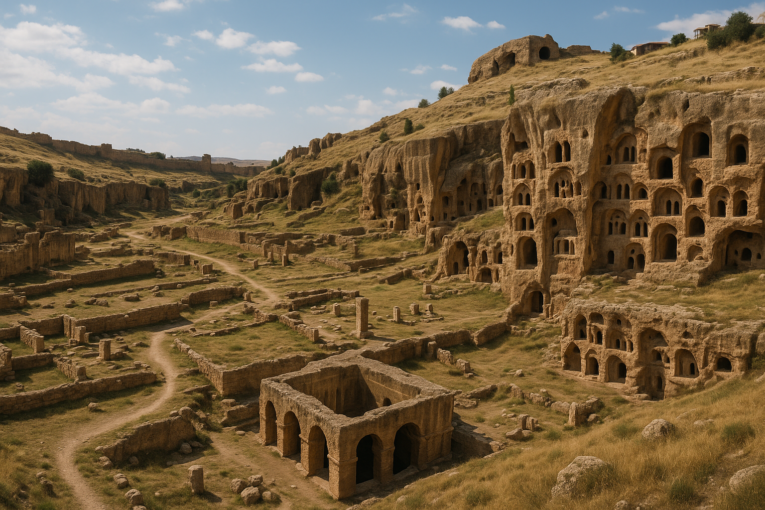
Architecture rupestre
La caractéristique la plus distinctive de Hasankeyf réside dans les milliers d'habitations troglodytes et d'espaces rupestres creusés dans les falaises calcaires de part et d'autre de la rivière :
Types d'espaces rupestres
- Grottes résidentielles — habitations à plusieurs pièces avec niches, étagères et conduits de ventilation taillés
- Églises — petites chapelles aux absides taillées, certaines avec des traces de décor peint
- Mosquées — salles de prière creusées dans la roche
- Salles de stockage — greniers et entrepôts pour les marchandises commerciales
- Citernes — chambres de collecte d'eau
- Passages défensifs — tunnels reliant différents niveaux de la falaise
Échelle
Avant le barrage, environ 5 000 à 6 000 espaces rupestres étaient visibles sur plusieurs kilomètres de paroi rocheuse. Beaucoup étaient à plusieurs étages, reliés par des escaliers et corridors intérieurs. Certaines grottes présentaient des détails architecturaux sculptés élaborés — arches, colonnes, encadrements de fenêtres — démontrant que l'habitat troglodyte à Hasankeyf n'était pas primitif mais constituait une tradition de construction sophistiquée et établie de longue date.
Continuité
De manière remarquable, certaines habitations troglodytes ont été habitées en continu jusqu'au XXe siècle. Les dernières familles troglodytes ne sont parties que dans les décennies précédant le barrage, perpétuant une tradition d'habitat rupestre s'étendant sur des millénaires.
Le pont artouqide
Le grand pont sur le Tigre était l'un des monuments les plus célèbres de Hasankeyf :
- Construit par la dynastie artouqide au XIIe siècle
- Présentait à l'origine de massives piles en pierre soutenant une superstructure en bois ou en pierre
- S'étendait sur environ 150 mètres à travers la rivière
- Le pont était l'un des plus grands ponts médiévaux du monde islamique
- À l'époque moderne, seules les piles en pierre ont survécu — massifs piliers cylindriques dressés dans la rivière
- Les piles du pont ont été submergées par les eaux du barrage d'Ilısu en 2020
Les piles du pont, dressées telles d'antiques sentinelles dans la rivière, constituaient l'image la plus emblématique de Hasankeyf avant le barrage.
Monuments religieux
Zeynel Bey Türbesi
Le tombeau de Zeynel Bey, fils du souverain Akkoyunlu Uzun Hasan, est une tour funéraire cylindrique au toit conique décoré de tuiles vernissées turquoise — l'un des plus beaux exemples d'architecture funéraire islamique du XVe siècle en Anatolie. Le türbe a été relocalisé dans le parc archéologique avant l'inondation due au barrage.
Grande Mosquée (Ulu Cami)
La Grande Mosquée de la période artouqide se dressait dans la ville basse, près de la rivière. Seul le minaret a survécu jusqu'à l'époque moderne. Le minaret a été submergé par le barrage.
Mosquée El-Rızk
La mosquée El-Rızk (XVe siècle), avec son minaret en pierre finement sculpté, était un autre monument islamique majeur. Le minaret a été relocalisé dans le parc archéologique.
Tombeau de l'Imam Abdullah
Une structure funéraire islamique médiévale qui a été relocalisée dans le parc archéologique avant l'inondation.
Églises rupestres
Plusieurs petites églises de l'époque byzantine étaient creusées dans les parois rocheuses, présentant :
- Des absides et des plateformes d'autel sculptées
- Des niches pour icônes
- Des traces de décor en plâtre peint
- Des symboles de croix et des inscriptions
Le barrage d'Ilısu et la submersion
Le barrage d'Ilısu, construit sur le Tigre à environ 65 km en aval de Hasankeyf, a été achevé en 2019 et a commencé à se remplir en 2020. En avril 2020, les eaux avaient monté jusqu'à submerger la majeure partie de la ville basse :
Ce qui a été submergé
- La ville basse (çarşı) avec ses bâtiments historiques restants
- Les piles du pont artouqide — le monument le plus emblématique de Hasankeyf
- Le minaret de l'Ulu Cami
- Des milliers d'habitations troglodytes de niveau inférieur le long de la base de la falaise
- Les abris-grottes néolithiques et les couches d'occupation anciennes
- Les fonds de vallée agricoles le long du Tigre
Efforts de relocalisation
Avant l'inondation, les autorités turques ont entrepris un programme de relocalisation :
- Zeynel Bey Türbesi — déplacé sur 2 km vers le nouveau parc archéologique
- Minaret de la mosquée El-Rızk — relocalisé
- Tombeau de l'Imam Abdullah — relocalisé
- Artuklu Hamamı (bain artouqide) — relocalisé
- Plusieurs structures plus petites ont été démontées et reconstruites dans le parc
Opposition internationale
Le barrage a fait face à une importante opposition internationale :
- ICOMOS et Europa Nostra ont classé Hasankeyf parmi les sites patrimoniaux les plus menacés d'Europe
- L'UNESCO a exprimé sa préoccupation face à la perte irréversible
- Des organisations archéologiques ont fait valoir que seul un cinquième du site avait été fouillé
- Des groupes environnementaux ont dénoncé la destruction de l'écosystème riverain du Tigre
- Environ 300 sites archéologiques le long du réservoir ont été affectés
- Plus de 25 000 personnes dans les villes de la vallée du Tigre ont été déplacées
Travaux archéologiques de sauvetage
Des fouilles archéologiques d'urgence ont été menées à Hasankeyf et sur les sites environnants avant l'inondation due au barrage :
- L'Université de Batman et l'Équipe de fouilles du site archéologique de Hasankeyf ont mené des fouilles de sauvetage
- Les couches néolithiques, de l'âge du bronze et médiévales ont été partiellement documentées
- Les trouvailles importantes ont été transférées au Musée de Batman et au nouveau parc archéologique
- Un scan 3D et une documentation photogrammétrique des grottes de paroi et des monuments ont été entrepris
- Cependant, les archéologues estiment que 85 % des vestiges archéologiques ont été submergés avant de pouvoir être correctement fouillés
Parc archéologique de Hasankeyf
Le Hasankeyf Arkeopark a été établi sur des terres plus élevées au-dessus du niveau d'eau du réservoir pour préserver les monuments relocalisés et offrir aux visiteurs une compréhension du patrimoine perdu :
Structures relocalisées
- Zeynel Bey Türbesi
- Minaret de la mosquée El-Rızk
- Tombeau de l'Imam Abdullah
- Artuklu Hamamı
- Présentations informatives sur la cité submergée
Expérience du visiteur
Le parc offre :
- Des monuments relocalisés dans un cadre paysager
- Des vues panoramiques sur le réservoir (où se dressait autrefois l'ancienne cité)
- Un espace muséal avec des artefacts issus des fouilles de sauvetage
- Des panneaux d'information documentant l'histoire et la perte de Hasankeyf
Ce qui a été perdu
La submersion de Hasankeyf représente l'une des pertes patrimoniales culturelles les plus importantes du XXIe siècle :
- Une séquence d'occupation ininterrompue de 12 000 ans — peu de sites au monde offrent une profondeur temporelle comparable
- Des milliers d'habitations troglodytes représentant une tradition architecturale unique
- Les piles du pont artouqide — parmi les vestiges d'ingénierie islamique médiévale les plus emblématiques
- Des abris-grottes néolithiques qui auraient pu fournir des données cruciales sur les origines de l'agriculture dans le Haut-Tigre
- Environ 85 % de dépôts archéologiques non fouillés — perdus avant toute investigation scientifique
- Le paysage vivant — la relation entre falaises, rivière, grottes et cité qui conférait à Hasankeyf son caractère unique
La perte est particulièrement poignante car Hasankeyf avait été proposée pour le statut de Patrimoine mondial de l'UNESCO mais n'a jamais été inscrite — le magazine SAPIENS l'a appelée « Le site UNESCO qui n'a jamais existé ».
Informations pour les visiteurs
Localisation : Province de Batman, à environ 37 km au sud-est de la ville de Batman.
Comment s'y rendre : En voiture depuis Batman (45 minutes). Batman possède un aéroport avec des vols intérieurs et des liaisons en bus depuis les grandes villes. La route vers Hasankeyf est bien indiquée.
Ce que vous pouvez voir aujourd'hui :
- La citadelle — au-dessus du niveau d'eau, accessible par route et sentier
- Les grottes supérieures de la falaise — les habitations troglodytes les plus hautes restent au-dessus de l'eau
- Le parc archéologique de Hasankeyf — monuments relocalisés et musée
- Le réservoir — où se dressaient autrefois la ville basse et les piles du pont
Horaires : Le parc archéologique est ouvert tous les jours. La zone de la citadelle a des heures de visite distinctes.
Admission : Frais d'entrée pour le parc archéologique.
Durée : 2 à 3 heures pour le parc, la citadelle et les zones de falaises restantes.
Conseils :
- L'expérience est émotionnellement puissante — comprendre ce qui repose sous l'eau ajoute de la profondeur
- Visitez d'abord le musée du parc pour avoir le contexte de la cité submergée
- La montée à la citadelle est raide mais gratifiante pour les vues panoramiques
- Combinez avec une visite du Musée de Batman pour les artefacts des fouilles de sauvetage
- Le printemps est la meilleure saison — le réservoir reflète les falaises dans la lumière du matin
- Apportez de l'eau et une protection solaire pour la montée à la citadelle
- La photographie est excellente depuis la citadelle dominant le réservoir
Foire aux questions
Hasankeyf est-elle sous l'eau ? La ville basse, les piles du pont et les grottes de niveau inférieur de la falaise ont été submergées par le réservoir du barrage d'Ilısu en 2020. La citadelle, les grottes supérieures et les monuments relocalisés dans le parc archéologique restent accessibles au-dessus de l'eau.
Peut-on toujours visiter Hasankeyf ? Oui. La citadelle, les grottes supérieures de la falaise et le parc archéologique de Hasankeyf sont ouverts aux visiteurs. L'expérience a fondamentalement changé, mais le site mérite toujours d'être visité.
Pourquoi n'a-t-elle pas été déclarée site du Patrimoine mondial de l'UNESCO ? La Turquie n'a jamais officiellement proposé Hasankeyf pour l'inscription à l'UNESCO, bien qu'elle en remplisse les critères. Le projet de barrage était déjà en cours, et l'inscription aurait compliqué la construction.
Quel âge a Hasankeyf ? Les preuves archéologiques indiquent 12 000 ans d'occupation humaine, du Néolithique à nos jours — l'un des plus longs témoignages d'habitation continue au monde.
Qu'était le pont artouqide ? Un massif pont du XIIe siècle sur le Tigre, construit par la dynastie artouqide. Seules ses piles en pierre ont survécu jusqu'à l'époque moderne avant d'être submergées par le barrage.
Des monuments ont-ils été sauvés ? Plusieurs monuments clés ont été relocalisés dans le parc archéologique, dont le Zeynel Bey Türbesi, le minaret de la mosquée El-Rızk et le tombeau de l'Imam Abdullah. Cependant, la majeure partie du patrimoine archéologique du site a été perdue.
Le pont artouqide : mesures d'ingénierie et analyse de la construction
L'Ancien Pont de Hasankeyf fut l'un des projets d'ingénierie les plus ambitieux du monde islamique médiéval. Les mesures détaillées effectuées avant la submersion documentent ce qui suit :
| Caractéristique | Mesure / Détail |
|---|---|
| Longueur totale du pont | env. 150 m à travers le Tigre |
| Nombre d'arches | 4 arches principales |
| Portée de l'arche centrale | env. 40 m (131 ft) — l'une des plus grandes portées d'arche médiévales au monde |
| Nombre de piles fluviales | 2 massives piles cylindriques dressées dans le lit de la rivière |
| Période de construction | env. 1147–1167 (milieu du XIIe siècle, période artouqide) |
| Construction des piles | Maçonnerie de pierre taillée sur noyau de moellons ; conçue pour la stabilité hydraulique dans une rivière sujette aux crues |
| Superstructure | À l'origine chaussée en pierre ou en bois (effondrée au début/milieu du XVIIe siècle) |
| Réparations ultérieures | XIVe siècle (souverains ayyoubides kurdes) ; XVe siècle (Turkmènes Aq Qoyunlu) |
| Effondrement final de la superstructure | Début à milieu du XVIIe siècle |
| Date de submersion | 2020 (remplissage du réservoir du barrage d'Ilısu) |
À l'époque de sa construction, l'arche centrale de 40 mètres était parmi les plus larges au monde — rivalisant ou dépassant les portées européennes contemporaines. La réussite d'ingénierie des Artouqides est comparable au pont de Malabadi à peu près contemporain (également artouqide, env. 1146–1147, près de Silvan) dont la portée de 38,6 m détenait le record médiéval pour les arches en pierre brisées.
La fouille d'une zone de 25 x 25 m à l'ouest de la route d'accès au pont a mis au jour un complexe de 15 pièces sans fenêtres aux murs en moellons cimentés à la boue et aux sols en pierre et terre battue — vraisemblablement des installations de stockage, de douane ou de garde desservant le passage du pont.
Tombeau de Zeynel Bey : détails architecturaux et ingénierie de relocalisation
Le Zeynel Bey Türbesi (env. 1473) est architecturalement unique en Anatolie :
| Caractéristique | Détail |
|---|---|
| Hauteur totale | env. 15 m (50 ft) |
| Diamètre du fût cylindrique | env. 7,6 m (25 ft) |
| Plan structurel | Extérieur circulaire, intérieur octogonal |
| Type de dôme | Dôme hémisphérique à double paroi (offrant une ventilation entre les coques) |
| Transition intérieure | Trompes à muqarnas faisant le passage octogone-cercle pour le support du dôme |
| Décoration extérieure | Motifs de briques diagonales avec tuiles vernissées bleu marine et turquoise |
| Portail | Porte à arc brisé sur la face nord |
| Fenêtre | Fenêtre unique sur le mur sud ; petites fenêtres aux points cardinaux sur le tambour supérieur |
| Parallèle stylistique | Tradition kümbet centrasiatique-azerbaïdjanaise (à partir du XIVe siècle) — seul exemple de ce style en Anatolie |
La relocalisation de 2017 fut un projet d'ingénierie de conservation sans précédent :
- Le tombeau a été déplacé sur 2 km horizontalement et 63 m verticalement en amont vers le nouveau parc archéologique
- Ce fut la première structure monumentale relocalisée de manière holistique en Anatolie (non démontée mais déplacée intacte sur une plateforme)
- Des vérins hydrauliques ont soulevé l'ensemble de la structure vieille de 550 ans depuis une base en béton spécialement construite
- La charge structurelle a été répartie équitablement sur la plateforme de levage pour éviter tout tassement différentiel ou fissuration
Frontière romaine et stratigraphie de la citadelle
Avant les Artouqides, Hasankeyf servit les intérêts stratégiques romains sous le nom de Kiphas (de l'araméen kepha, « roche ») :
| Période | Évidence à Hasankeyf |
|---|---|
| Romaine (IIe–IVe siècle ap. J.-C.) | Base de garnison légionnaire ; poste frontalier sur la frontière perse ; capitale de la province d'Arzanène pendant une période |
| Byzantine (Ve–VIIe siècle) | Églises rupestres aux absides sculptées et au plâtre peint ; entretien du mur de fortification |
| Début islamique (VIIe–XIe siècle) | Conversion des églises rupestres ; passage de route commerciale entre Bagdad et l'Anatolie |
| Artouqide (XIIe–XVe siècle) | Apogée de la construction monumentale : pont, palais, mosquées, madrasas |
Les récentes fouilles de sauvetage sur le sommet de la citadelle ont révélé :
- Une maçonnerie de l'époque romaine sous les murs de fortification artouqides médiévaux, confirmant un usage militaire multi-périodes s'étendant sur au moins 1 500 ans
- Des citernes d'eau rupestres aux capacités suffisantes pour soutenir une garnison lors d'un siège prolongé
- Des fragments de briques et tuiles romaines intégrés dans les phases de construction ultérieures
- Un système de passage rupestre reliant le sommet de la citadelle à la base de la falaise, fournissant un accès dissimulé à la rivière
Quantifier la perte patrimoniale
L'ampleur de ce qui a été perdu à cause du barrage d'Ilısu peut être exprimée en chiffres précis :
| Métrique | Valeur |
|---|---|
| Habitations troglodytes estimées visibles avant le barrage | 5 000–6 000 sur plusieurs km de paroi rocheuse |
| Sites archéologiques affectés le long du réservoir | env. 300 |
| Personnes déplacées des villes de la vallée du Tigre | Plus de 25 000 |
| Pourcentage de dépôts archéologiques submergés non fouillés | Estimé à 85 % |
| Monuments relocalisés avec succès | 4 structures majeures (Zeynel Bey Türbesi, minaret de la mosquée El-Rızk, tombeau de l'Imam Abdullah, Artuklu Hamamı) |
| Années d'occupation humaine continue documentées | env. 12 000 (du Néolithique au XXIe siècle) |
| Début du remplissage du réservoir | 2020 |
| Distance en aval du barrage d'Ilısu | env. 65 km de Hasankeyf |
Les efforts de documentation avant l'inondation incluaient le scan laser 3D et la modélisation photogrammétrique des grottes de paroi et des monuments en élévation. Cependant, les archéologues de l'Université de Batman et de l'Équipe de fouilles du site archéologique de Hasankeyf ont souligné que cet enregistrement numérique, bien que précieux, ne peut se substituer à l'examen physique des dépôts stratifiés désormais définitivement inaccessibles sous le réservoir.
Sources et lectures complémentaires
- SAPIENS Magazine, « The UNESCO Site That Never Was » — analyse de la perte patrimoniale de Hasankeyf
- National Geographic, « New Dam in Turkey Threatens to Flood Ancient City » (2014)
- National Geographic, « Medieval Turkish Tomb Relocated to Escape Ilisu Dam Flooding » (2017)
- Ancient Origins, « The 12,000-Year-Old Ancient Mesopotamian Town of Hasankeyf »
- Columbia University MCID, « Hasankeyf » — Mapping Mesopotamian Monuments
- Informations officielles du Hasankeyf Arkeopark
- Musée de Batman — artefacts des fouilles de sauvetage
- Europa Nostra — alertes patrimoniales de Hasankeyf
- Wikipedia, « Hasankeyf » et « Old Bridge, Hasankeyf » — aperçu et bibliographie exhaustifs
- Daily Sabah, « Excavations reveal ancient Roman ruins in Hasankeyf, Türkiye »
- Montesca/ProCultHer, « The Conservation and Recovery Project of Zeynel Bey Tomb in Hasankeyf » (rapport technique)
- ArchNet, « Zeynel Bey Türbesi Hasankeyf » (archnet.org/sites/3637)