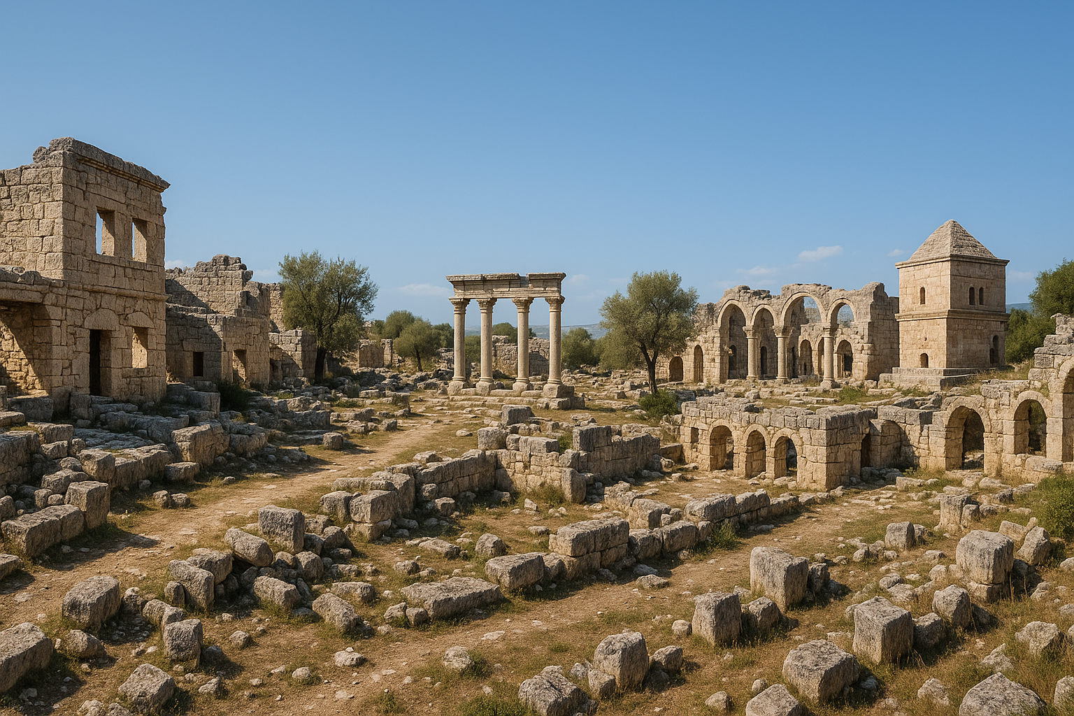
Vue d'ensemble : Kanlıdivane, l'ancienne Kanytelis (également Kanytelleis/Canytellis), est l'un des sites archéologiques les plus saisissants et envoûtants du sud de la Türkiye — un établissement construit autour et au-dessus d'un immense gouffre naturel (obruk) sur le plateau calcaire de l'ancienne Cilicie Trachée (Cilicia Tracheia). Situé près de la côte dans le district d'Erdemli, dans la province de Mersin, le site tire son nom turc de « Kanlı Divane » signifiant « Lieu sanglant de la folie » — une référence aux légendes selon lesquelles les criminels étaient jetés dans le gouffre en guise de châtiment. Le gouffre mesure approximativement 70 mètres de profondeur, 144 mètres de long et 90 mètres de large, créant un amphithéâtre naturel spectaculaire. Autour de son rebord et dans les environs subsistent des vestiges remarquables, notamment cinq basiliques paléochrétiennes (l'une commandée par l'empereur Théodose II), des tombes-tours monumentales, une tour hellénistique, des tombes rupestres, une nécropole romaine et des traces du culte de Zeus Olbios. Le site offre une combinaison singulièrement puissante de merveille naturelle et de patrimoine antique.
Table des matières
- Pourquoi Kanlıdivane compte
- Géographie et contexte
- Chronologie historique
- Le grand gouffre
- Le nom : « Lieu sanglant de la folie »
- L'ancienne Kanytelis
- Le culte de Zeus Olbios
- La tour hellénistique
- Les basiliques
- La basilique de l'empereur Théodose II
- Les tombes-tours
- Tombes rupestres et nécropole
- Reliefs sculptés sur les parois du gouffre
- La voie romaine et l'établissement
- Olba et les rois-prêtres
- La Kanytelis byzantine
- Recherche archéologique
- Comment visiter Kanlıdivane
- FAQ
- Sources
Pourquoi Kanlıdivane compte
Kanlıdivane est significatif pour plusieurs raisons convaincantes :
- Gouffre naturel spectaculaire : Le gouffre massif — 70 mètres de profondeur, 144 mètres de long, 90 mètres de large — est l'une des formations géologiques les plus impressionnantes utilisées comme cœur d'un établissement dans le monde antique
- Cinq basiliques : Une concentration inhabituellement élevée d'églises paléochrétiennes pour un établissement relativement petit, indiquant une importance religieuse exceptionnelle
- Basilique de Théodose II : L'une des basiliques fut construite sur ordre de l'empereur Théodose II (r. 408–450) — patronage impérial pour une petite ville cilicienne
- Tombes-tours : Tours funéraires monumentales à plusieurs étages — une forme architecturale ciliciote trachée distinctive, rarement trouvée ailleurs
- Culte de Zeus Olbios : Le site était lié au puissant culte de Zeus Olbios basé à proximité, à Olba (Uzuncaburç) — l'un des États-temples les plus importants de Cilicie
- Tour hellénistique : Une tour de guet bien préservée datant de la période hellénistique démontre le rôle stratégique de l'établissement
- Reliefs sculptés : Des reliefs gravés sur les parois du gouffre, dont une figure de guerrier et un groupe familial, offrent des aperçus uniques de la croyance et de la société locales
- Cadre atmosphérique : La combinaison de l'immense gouffre, des ruines antiques, de la végétation méditerranéenne et des vues sur la mer crée une atmosphère inoubliable
Géographie et contexte
Kanlıdivane occupe un plateau calcaire surplombant la côte méditerranéenne du sud de la Türkiye.
Emplacement :
- Près du village de Kumkuyu, district d'Erdemli, province de Mersin
- Sur le plateau côtier ciliciote, à environ 3 km du rivage méditerranéen
- À environ 60 km à l'ouest du centre-ville de Mersin
- À environ 20 km à l'est de Silifke
- Altitude : environ 200 mètres au-dessus du niveau de la mer
- Faisant partie de l'ancienne région de Cilicie Trachée (Cilicia Tracheia) — ainsi nommée pour son terrain calcaire accidenté
Paysage :
- Plateau calcaire rocheux profondément entaillé par des gouffres (obruks) et des gorges
- Végétation méditerranéenne — maquis bas, oliviers, caroubiers et herbes sauvages
- La mer Méditerranée est visible depuis le site
- Le terrain est karstique — calcaire poreux truffé de grottes, gouffres et cours d'eau souterrains
- L'établissement antique s'étendait sur le plateau autour du gouffre
- Les fleurs sauvages couvrent le site au printemps, créant un beau contraste avec les ruines calcaires grises
Climat :
- Climat méditerranéen — étés chauds et secs, hivers doux et pluvieux
- L'emplacement côtier modère les températures
- Le site est exposé au soleil et au vent — apporter une protection
Chronologie historique
| Période | Date | Événements clés |
|---|---|---|
| Hellénistique | IIIe–Ier siècle av. J.-C. | Établissement fondé ; tour hellénistique construite ; connexion au royaume sacerdotal d'Olba |
| République romaine | Ier siècle av. J.-C. | Région pacifiée par Rome ; Pompée réprime les pirates ciliciens |
| Empire romain | Ier–IIIe siècle apr. J.-C. | L'établissement se développe ; tombes-tours construites ; nécropole établie |
| Premier byzantin | IVe–Ve siècle | Conversion chrétienne ; basiliques construites, dont l'église de Théodose II |
| Byzantin | VIe–VIIe siècle | Habitation continue ; construction d'églises supplémentaires |
| Raids arabes | VIIe–Xe siècle | Déclin dû à la guerre frontalière arabo-byzantine |
| Médiéval | XIe–XIVe siècle | Habitation réduite ; royaume arménien de Cilicie |
| Ottoman | À partir du XVe siècle | Abandonné ; ruines partiellement réutilisées par les agriculteurs locaux |
| Moderne | XXe–XXIe siècle | Documentation archéologique et conservation |
Le grand gouffre
Le gouffre (obruk) de Kanlıdivane est la caractéristique déterminante du site — un colossal abîme naturel dans le plateau calcaire.
Dimensions :
- Profondeur : environ 70 mètres
- Longueur : environ 144 mètres
- Largeur : environ 90 mètres
- Les parois sont des falaises calcaires escarpées à verticales
- Le fond est couvert de végétation — arbres, buissons et plantes sauvages poussent dans le microclimat abrité du fond
Formation géologique :
- Le gouffre s'est formé par karstification — la dissolution graduelle du calcaire par l'eau pendant des millions d'années
- L'eau souterraine a dissous la roche, créant une caverne qui s'est finalement effondrée, formant l'abîme ouvert
- Le plateau ciliciote est truffé de telles formations karstiques, mais le gouffre de Kanlıdivane figure parmi les plus grands
Usage humain :
- Les anciens considéraient le gouffre avec révérence — il était probablement vu comme un passage vers le monde souterrain
- Les parois du gouffre ont été sculptées de reliefs (voir ci-dessous)
- Selon la légende, les criminels étaient jetés dans la fosse en guise de châtiment — d'où le nom turc
- Le rebord du gouffre devint le point focal de l'établissement — les bâtiments furent construits aussi près du bord que possible
- Le fond abrité du gouffre soutenait une végétation luxuriante, offrant un contraste avec le plateau aride au-dessus
Le nom : « Lieu sanglant de la folie »
Le nom turc Kanlıdivane se traduit par « Lieu sanglant de la folie » (ou « asile ensanglanté »).
Étymologie :
- Kanlı = « sanglant » (de kan = sang)
- Divane = « asile » ou « lieu de folie/frénésie » (du persan divāne)
Les légendes :
- La tradition locale veut que les criminels, les fous ou les prisonniers condamnés étaient jetés dans le gouffre pour y mourir
- Le sang des victimes maculant les rochers aurait donné au site son nom sinistre
- Certaines versions de la légende précisent que le châtiment était réservé aux crimes particulièrement odieux
- Que ces légendes reflètent une pratique réelle ou soient des explications populaires pour le gouffre effrayant fait débat
Nom antique :
- Le nom antique Kanytelis (Kanytelleis) n'a pas de lien étymologique clair avec le nom turc
- Le changement de nom de Kanytelis à Kanlıdivane s'est produit pendant la période turco-musulmane, lorsque l'apparence effrayante du gouffre a inspiré le nom populaire dramatique
L'ancienne Kanytelis
Kanytelis était un établissement d'importance secondaire dans le vaste territoire de l'État sacerdotal puissant d'Olba.
L'établissement :
- Kanytelis n'était pas une grande cité mais un village important ou une petite ville dans le territoire d'Olba
- Son importance provenait de sa position sur les routes reliant la côte à l'intérieur
- L'établissement faisait partie du territoire des rois-prêtres d'Olba, qui gouvernaient un État-temple dédié à Zeus Olbios
- Pendant la période romaine, l'établissement s'est développé et a acquis une architecture monumentale — tombes-tours, nécropole, et finalement basiliques
Relation avec Olba :
- Olba (l'actuelle Uzuncaburç, à environ 30 km à l'intérieur des terres) était le centre dominant — patrie du temple de Zeus Olbios et siège des rois-prêtres
- Kanytelis fonctionnait comme un établissement satellite dans le territoire olbien
- Le culte de Zeus Olbios à Olba influençait la vie religieuse à Kanytelis
- La tour hellénistique de Kanytelis a pu servir d'avant-poste ou de tour de guet pour le royaume sacerdotal d'Olba
Le culte de Zeus Olbios
Le paysage religieux de Kanytelis fut façonné par le puissant culte de Zeus Olbios centré sur la proche Olba.
Zeus Olbios :
- Zeus Olbios (« Zeus le Prospère/Béni ») était la principale divinité de la région
- Son temple à Olba (Uzuncaburç) — un magnifique temple corinthien encore debout avec ses colonnes — était le centre religieux d'un vaste territoire
- Les rois-prêtres d'Olba, de la dynastie des Teucrides, gouvernaient à la fois le temple et son territoire environnant avec une autorité semi-royale
- Le culte combinait le culte grec de Zeus avec les traditions religieuses ciliciotes indigènes
À Kanytelis :
- En tant que partie du territoire olbien, Kanytelis se trouvait dans la sphère religieuse de Zeus Olbios
- Le gouffre lui-même pouvait avoir une signification cultuelle — les abîmes profonds étaient souvent associés au monde souterrain et aux divinités chthoniennes
- Des inscriptions trouvées sur le site font référence aux institutions religieuses de la région
- La transition du culte de Zeus Olbios au christianisme est visible dans la séquence architecturale du site — les sanctuaires païens cédant la place aux basiliques chrétiennes
La tour hellénistique
Une tour hellénistique bien préservée se dresse près du rebord du gouffre.
Description :
- Une tour de pierre rectangulaire d'environ 8 mètres de haut (hauteur subsistante)
- Construite en blocs de calcaire soigneusement taillés en assises régulières
- Datant du IIe–Ier siècle av. J.-C. (période hellénistique)
- La tour possède de petites fenêtres et une porte au-dessus du niveau du sol (accédée par une échelle rétractable pour la défense)
- Pièces intérieures sur plusieurs niveaux
Fonction :
- La tour servait probablement à plusieurs fins :
- Tour de guet : Vues dominantes sur le plateau et vers la côte — surveillance des raids de pirates ou des menaces militaires
- Tour de refuge : Position défensive où la population locale pouvait s'abriter pendant les attaques
- Poste administratif : Possiblement un avant-poste du royaume sacerdotal olbien, contrôlant les routes et collectant les péages
- Des tours similaires se trouvent dans toute la Cilicie Trachée — elles reflètent l'insécurité de la région, qui fut accablée par la piraterie et le brigandage avant la pacification romaine
Importance :
- La tour est l'une des structures défensives hellénistiques les mieux préservées de Cilicie
- Elle illustre la réponse architecturale à l'insécurité chronique de la Cilicie Trachée pré-romaine
- La campagne de Pompée contre les pirates ciliciens (67 av. J.-C.) finit par réduire le besoin de telles tours
Les basiliques
Kanlıdivane possède une concentration extraordinaire de cinq basiliques paléochrétiennes — un nombre inhabituellement élevé pour un établissement relativement petit.
Basilique 1 (Basilique nord-ouest) :
- Une grande basilique à trois nefs près du bord nord-ouest du gouffre
- Murs et abside bien préservés
- Datée du Ve siècle
- Fragments de sol en mosaïque
Basilique 2 (Basilique de Théodose II) :
- L'église la plus importante — construite avec un patronage impérial (voir ci-dessous)
- Située sur le côté nord du gouffre
Basilique 3 (Basilique sud) :
- Sur le côté sud de l'établissement
- Plus petite que les deux premières basiliques
- Datée du Ve–VIe siècle
Basiliques 4 et 5 :
- Églises supplémentaires plus petites dans la zone de l'établissement
- Démontrant la christianisation profonde de la communauté
- Certaines construites sur ou près d'anciens sites de culte païens
Pourquoi tant de basiliques ?
- La concentration de cinq églises indique que Kanytelis avait une signification religieuse exceptionnelle à l'époque paléochrétienne
- Le site a pu être une destination de pèlerinage — peut-être lié à un saint local ou à une tradition de martyre
- Le patronage impérial (Théodose II) a renforcé le prestige du site et attiré la construction d'autres églises
- L'évêque de la proche Olba/Diocésarée a pu promouvoir la construction d'églises dans le territoire
La basilique de l'empereur Théodose II
La basilique la plus importante de Kanlıdivane fut construite sur les ordres de l'empereur Théodose II (r. 408–450 apr. J.-C.).
La basilique :
- Une grande basilique à trois nefs sur le côté nord du gouffre
- Une inscription enregistre que l'église fut construite avec des fonds impériaux — un honneur rare et prestigieux pour un petit établissement
- Détails architecturaux raffinés, dont chapiteaux de colonnes sculptés et moulures de portes
- Une abside à l'extrémité orientale
- Narthex (vestibule d'entrée) à l'extrémité occidentale
- Datée de la première moitié du Ve siècle
Théodose II :
- L'un des empereurs romains au plus long règne (42 ans)
- Connu pour les murs théodosiens de Constantinople, le Codex Theodosianus (code de lois) et le concile d'Éphèse (431)
- Son patronage d'une basilique dans la lointaine Kanytelis suggère que le site avait une importance religieuse particulière — peut-être associé à un saint, une relique ou une tradition locale de sainteté
- La construction d'églises impériales était un outil de politique religieuse — démontrant l'engagement de l'empereur à christianiser l'empire
Les tombes-tours
Les tombes-tours de Kanlıdivane sont parmi les monuments les plus distinctifs du site — une forme funéraire caractéristique de la Cilicie Trachée.
Description :
- Tours de pierre monumentales à plusieurs étages construites comme monuments funéraires
- Généralement de 2 à 3 étages, certaines atteignant 8 à 10 mètres de hauteur
- Construites en blocs de calcaire soigneusement taillés
- Chambres funéraires à l'intérieur de la structure de la tour
- Certaines tours portent des inscriptions sculptées identifiant le défunt et sa famille
- Décoration architecturale sur certaines tours — corniches, pilastres et reliefs sculptés
Exemples clés à Kanlıdivane :
- Plusieurs tombes-tours se dressent près de l'établissement et le long de l'ancienne route
- Les exemples les mieux préservés conservent leur hauteur complète et leurs détails architecturaux
- Une tombe-tour notable se dresse de manière imposante près du rebord du gouffre
Importance :
- Les tombes-tours sont une forme funéraire typiquement ciliciote — trouvées principalement en Cilicie Trachée et rarement ailleurs
- Elles démontrent la richesse et le statut des familles d'élite locales
- L'investissement dans l'architecture funéraire monumentale reflète l'importance de commémorer les morts dans la culture ciliciote
- Des tombes-tours similaires peuvent être vues à Olba (Uzuncaburç), Elaiussa Sebaste et d'autres sites ciliciens
Tombes rupestres et nécropole
En plus des tombes-tours, Kanlıdivane possède de vastes tombes rupestres et une nécropole romaine.
Tombes rupestres :
- Tombes taillées directement dans le substrat calcaire et dans les parois du gouffre lui-même
- Certaines ont des façades architecturales — portes sculptées, frontons et éléments décoratifs
- Niches funéraires (loculi) à l'intérieur pour plusieurs inhumations
- Datant de la période hellénistique jusqu'au début de la période byzantine
- Certaines tombes sur les parois du gouffre ne sont accessibles qu'en grimpant — suggérant que l'inaccessibilité faisait partie de leur sécurité
La nécropole :
- Une zone formelle de cimetière romain avec sarcophages, enclos funéraires et inscriptions funéraires
- Située le long de l'ancienne route menant à l'établissement
- Certains sarcophages sont décorés de guirlandes, de tabulae ansatae (cadres d'inscriptions) et de scènes mythologiques
- La nécropole démontre toute la gamme des pratiques funéraires romaines en Cilicie
Reliefs sculptés sur les parois du gouffre
Les parois du gouffre contiennent des reliefs sculptés — l'une des caractéristiques les plus intrigantes de Kanlıdivane.
Les reliefs :
- Sculptés directement dans les parois calcaires du gouffre
- Une figure de guerrier : Un relief sculpté d'un homme armé, possiblement un soldat ou un héros
- Un groupe familial : Un relief montrant une famille — interprété comme une gravure funéraire ou votive
- Autres figures : Figures et symboles sculptés supplémentaires, certains érodés et difficiles à interpréter
- Les reliefs se trouvent à diverses hauteurs sur les parois du gouffre — certains assez hauts pour avoir nécessité des cordes ou des échafaudages pour la sculpture
Interprétation :
- Les reliefs peuvent avoir une signification religieuse — le gouffre comme espace sacré reliant le monde humain au monde souterrain
- La figure du guerrier pourrait représenter une divinité locale, un héros ou un guerrier défunt
- Le groupe familial peut être une offrande votive — une famille se consacrant à la protection des puissances chthoniennes de l'abîme
- Certains chercheurs lient les reliefs au culte de Zeus Olbios ou aux traditions funéraires locales
La voie romaine et l'établissement
Kanytelis se trouvait sur une voie romaine reliant la côte à l'intérieur.
La voie :
- Une voie romaine pavée passait par ou près de l'établissement
- La voie reliait les cités côtières (Elaiussa Sebaste, Korykos) à Olba (Uzuncaburç) dans les hautes terres intérieures
- Des sections de la voie avec les pavés d'origine sont visibles près du site
- La voie facilitait le commerce, le mouvement militaire et le pèlerinage
L'établissement :
- L'établissement de l'époque romaine s'étendait sur le plateau autour du gouffre
- Structures résidentielles, citernes pour le stockage de l'eau et installations agricoles
- L'établissement ne fut jamais une grande cité — il fonctionnait comme un village ou une petite ville desservant le territoire agricole environnant et les voyageurs sur la route
- Des pressoirs à huile et à vin indiquent le traitement agricole — les olives et les raisins étaient les principales cultures
Olba et les rois-prêtres
L'histoire de Kanytelis est inséparable du puissant État sacerdotal d'Olba (Uzuncaburç).
Le royaume sacerdotal olbien :
- Olba était centrée sur le magnifique temple de Zeus Olbios — un temple corinthien dont les colonnes se dressent encore aujourd'hui
- L'État-temple était gouverné par des rois-prêtres de la dynastie des Teucrides — revendiquant la descendance du héros grec Teucer (frère d'Ajax)
- Les rois-prêtres contrôlaient un vaste territoire en Cilicie Trachée, y compris Kanytelis
- Sous la domination romaine, la dynastie sacerdotale fut transformée — le territoire devint la cité de Diocésarée (Uzuncaburç)
Lien avec Kanytelis :
- Kanytelis faisait partie du territoire olbien — religieusement, politiquement et économiquement dépendante du royaume sacerdotal
- La tour hellénistique de Kanytelis a probablement servi d'avant-poste de l'administration olbienne
- Lorsque le territoire olbien fut réorganisé sous Rome, Kanytelis devint partie du nouveau territoire civique
- Les visiteurs intéressés par Kanytelis devraient également visiter Uzuncaburç (Olba/Diocésarée) — les deux sites sont historiquement liés
La Kanytelis byzantine
À l'époque byzantine, Kanytelis fut transformée par le christianisme.
Christianisation :
- La transition du culte païen au christianisme s'est produite au cours du IVe siècle
- La construction de cinq basiliques a transformé le paysage de l'établissement
- Le patronage impérial (Théodose II) a élevé le prestige du site
- L'évêché était basé à Olba/Diocésarée, mais Kanytelis pouvait avoir un prêtre résident ou une communauté monastique
Déclin :
- Les raids arabes des VIIe–Xe siècles ont dévasté la côte cilicienne
- La frontière entre l'Empire byzantin et le Califat arabe traversait la Cilicie
- Kanytelis fut probablement abandonnée ou réduite à une poignée d'habitants pendant cette période
- Le royaume arménien de Cilicie (XIe–XIVe siècles) a pu brièvement réoccuper le site
- À l'époque ottomane, le site était complètement abandonné et est devenu le paysage en ruines hantant visible aujourd'hui
Recherche archéologique
L'investigation archéologique à Kanlıdivane a documenté les remarquables vestiges du site.
Recherche clé :
- Les premiers visiteurs et voyageurs (XIXe siècle) ont documenté les ruines et le gouffre
- Des relevés plus systématiques au XXe siècle ont catalogué les monuments
- Des équipes archéologiques turques ont mené des travaux de conservation et de documentation
- Les basiliques, les tombes-tours et la tour hellénistique ont été étudiées en détail
- Les inscriptions trouvées sur le site ont été publiées
Conservation :
- Le site est sous la protection du ministère turc de la Culture et du Tourisme
- Des panneaux d'information expliquent les monuments clés
- Des passerelles et des barrières protègent les visiteurs du bord du gouffre
- Le site a été aménagé pour le tourisme avec une billetterie et des installations pour visiteurs
Travaux en cours :
- Documentation et conservation continues des basiliques et des tombes-tours
- Étude des reliefs sculptés sur les parois du gouffre
- Intégration de Kanlıdivane dans le réseau plus large du patrimoine archéologique cilicien
Comment visiter Kanlıdivane
S'y rendre :
- Depuis Mersin : environ 60 km à l'ouest (environ 1 heure par l'autoroute côtière D-400)
- Depuis Silifke : environ 20 km à l'est (environ 25 minutes)
- Depuis Kızkalesi (Korykos) : environ 10 km à l'ouest (environ 15 minutes)
- Tourner vers l'intérieur depuis l'autoroute D-400 à Kumkuyu — le site est à environ 3 km de la côte
- Signalé depuis l'autoroute
- Pas de transport public régulier vers le site ; taxi depuis Erdemli/Kızkalesi ou voiture de location
Le site :
- Prévoir 1,5 à 2 heures pour une visite approfondie
- Arrêts clés : Le gouffre (points de vue autour du rebord), tour hellénistique, Basilique 1 et basilique de Théodose II, tombes-tours, tombes rupestres, reliefs sculptés (visibles depuis le rebord), nécropole
- Le site est relativement compact — tous les monuments sont à distance de marche
- Barrières de sécurité le long du bord du gouffre — faire preuve de prudence
- Une billetterie et des installations de base sont disponibles
Meilleur moment pour visiter :
- Le printemps (mars–mai) est idéal — fleurs sauvages, températures agréables, excellente lumière pour la photographie
- L'automne (octobre–novembre) est également excellent
- L'été est très chaud — visiter tôt le matin ou en fin d'après-midi
- L'hiver est doux mais certains jours peuvent être pluvieux
Conseils pratiques :
- Porter des chaussures de marche robustes — le terrain calcaire est inégal
- Apporter de l'eau et une protection solaire — ombre limitée sur le plateau
- La photographie est exceptionnelle — les vues du gouffre sont spectaculaires
- Combiner avec des visites à Uzuncaburç (Olba/Diocésarée), Kızkalesi (Korykos) et aux gouffres de Cennet-Cehennem (Ciel-Enfer) à proximité
- La ville côtière de Kızkalesi possède des hôtels, des restaurants et le célèbre château maritime
Sites à proximité :
- Cennet-Cehennem (gouffres du Ciel et de l'Enfer) : 5 km — formations karstiques similaires avec une chapelle byzantine
- Kızkalesi/Korykos : 10 km — spectaculaire château maritime et château terrestre
- Uzuncaburç (Olba) : 30 km à l'intérieur des terres — temple de Zeus Olbios avec colonnes debout
- Adamkayalar : Reliefs rupestres de figures de l'époque romaine
- Elaiussa Sebaste : Ancienne cité romaine près de la côte
FAQ
Q : Qu'est-ce que le gouffre ? R : Un immense abîme naturel dans le plateau calcaire — environ 70 mètres de profondeur, 144 mètres de long et 90 mètres de large. Il s'est formé par des millions d'années de dissolution du calcaire par l'eau (karstification).
Q : Pourquoi l'appelle-t-on « Lieu sanglant de la folie » ? R : La légende locale dit que les criminels étaient jetés dans le gouffre en guise de châtiment. Que cela se soit réellement produit fait débat, mais le nom dramatique est resté.
Q : Quel est le lien avec Olba ? R : Kanytelis faisait partie du territoire du puissant État sacerdotal d'Olba (l'actuelle Uzuncaburç), qui était centré sur le culte de Zeus Olbios. La tour hellénistique de Kanytelis a pu être un avant-poste olbien.
Q : Pourquoi y a-t-il tant de basiliques ? R : Cinq basiliques paléochrétiennes indiquent une importance religieuse exceptionnelle — possiblement comme site de pèlerinage. L'une fut construite avec des fonds impériaux de l'empereur Théodose II, suggérant un lien avec un saint local ou un lieu saint.
Q : Que sont les tombes-tours ? R : Tours funéraires monumentales en pierre à plusieurs étages caractéristiques de la Cilicie Trachée. Elles furent construites par de riches familles locales et représentent une tradition architecturale typiquement ciliciote.
Q : Le site est-il sûr ? R : Oui. Des barrières de sécurité et des passerelles protègent les visiteurs le long du rebord du gouffre. Cependant, faire preuve de prudence près du bord.
Q : Peut-on descendre dans le gouffre ? R : Généralement non — les parois du gouffre sont des falaises escarpées. Les ruines et les reliefs sculptés se voient depuis le rebord au-dessus.
Q : Comment Kanlıdivane est-il lié aux sites voisins ? R : Il fait partie d'un riche ensemble de sites antiques en Cilicie Trachée : Uzuncaburç (Olba), Kızkalesi (Korykos), Cennet-Cehennem et Elaiussa Sebaste. Tous peuvent être visités en un jour ou deux.
Mesures architecturales et relevé structurel
La documentation détaillée des monuments de Kanlıdivane a produit les mesures structurelles suivantes, fournissant un enregistrement architectural de l'un des établissements les plus importants de la Cilicie Trachée.
| Monument | Dimensions / Mesures | Date | Notes |
|---|---|---|---|
| Grand gouffre | 70 m de profondeur × 144 m de long × 90 m de large | Formation naturelle | Effondrement karstique ; parois calcaires escarpées à verticales |
| Tour hellénistique | 17 m de hauteur (subsistante) | IIe–Ier siècle av. J.-C. | Plan rectangulaire ; plusieurs étages ; petites fenêtres |
| Basilique n° 1 (Nord-ouest) | À trois nefs ; abside partiellement préservée | Ve siècle apr. J.-C. | Fragments de sol en mosaïque dans la nef |
| Basilique n° 2 (Théodose II) | À trois nefs ; narthex + abside | Première moitié du Ve siècle apr. J.-C. | Inscription de patronage impérial |
| Basilique n° 3 (Sud) | Plus petite que les Basiliques 1–2 | Ve–VIe siècle apr. J.-C. | Secteur sud de l'établissement |
| Basilique n° 4 | Structure la mieux préservée du site | Ve–VIe siècle apr. J.-C. | Symbole de Kanlıdivane ; visible de loin |
| Basilique n° 5 | Traces découvertes en 2011 | Ve–VIe siècle apr. J.-C. | Localisée lors des récentes campagnes de fouilles |
| Tombe-temple du IIe siècle | Forme de tour à plusieurs étages | IIe siècle apr. J.-C. | Située dans la zone de la nécropole |
La tour hellénistique porte une inscription dédicatoire qui se lit : « Construite par Teukros, fils du roi-prêtre Tarkyaris d'Olba pour Zeus. » Cette inscription relie directement la tour à la dynastie sacerdotale olbienne et confirme le lien administratif de l'établissement avec les rois-prêtres teucrides qui contrôlaient la Cilicie Trachée depuis le temple de Zeus Olbios à proximité, à Uzuncaburç.
Chronologie des fouilles et historique de la recherche
| Période | Chercheurs / Institution | Contributions clés |
|---|---|---|
| XIXe siècle | Voyageurs européens | Première documentation occidentale du gouffre et des ruines |
| Années 1980 | Semavi Eyice et équipes de prospection | Prospection systématique des complexes religieux ; identification des plans de basiliques |
| Années 1990 | Richard Bayliss et collaborateurs | Documentation détaillée de l'architecture des églises ; analyse de la transition païen-chrétien |
| 2011 | Équipes archéologiques turques | Découverte de la Basilique n° 5 ; affinement de la chronologie du site |
| 2014–présent | Initiatives de conservation | Inscription sur la Liste indicative de l'UNESCO ; atténuation de l'érosion le long du rebord du gouffre |
Depuis 2014, Kanytelis détient le statut indicatif sur la Liste du patrimoine mondial de l'UNESCO, ce qui a déclenché des programmes de conservation en cours qui traitent de l'érosion sévère affectant les bords du gouffre et de la stabilité structurelle des monuments environnants. L'inclusion du site sur la Liste indicative s'inscrit dans un effort plus large visant à obtenir la reconnaissance du patrimoine mondial pour le remarquable héritage archéologique de la côte cilicienne.
Reliefs sculptés : analyse iconographique
Les reliefs sculptés sur les parois du gouffre ont fait l'objet d'études iconographiques détaillées, livrant des aperçus sur la pratique religieuse locale et la croyance funéraire.
| Relief | Emplacement sur la paroi du gouffre | Description | Interprétation |
|---|---|---|---|
| Figure de guerrier | Paroi est, à mi-hauteur | Homme armé en costume régional ; casque et lance | Héros local, divinité, ou dédicace militaire |
| Groupe familial | Paroi nord | Figures d'homme, de femme et d'enfant en pose frontale | Funéraire ou votif ; dédicace familiale aux puissances chthoniennes |
| Figures fragmentaires | Hauteurs diverses | Formes humaines érodées et gravures symboliques | Possiblement liées au culte de Zeus Olbios ou aux rites du monde souterrain |
Le placement des reliefs à des hauteurs considérables sur les parois de la falaise implique l'usage de cordes ou d'échafaudages, suggérant un effort communal organisé plutôt qu'une sculpture individuelle. Certains chercheurs interprètent le gouffre lui-même comme un espace liminal sacré entre le monde humain et le monde souterrain, où les reliefs fonctionnaient comme des offrandes permanentes ou des marqueurs territoriaux pour les morts.
Le renommage en Néapolis et le patronage impérial
Lorsque l'empereur Théodose II parraina la construction de la basilique principale (Basilique n° 2) dans la première moitié du Ve siècle, l'établissement reçut, dit-on, le nouveau nom de Néapolis (« Nouvelle Cité »), reflétant sa transformation en centre religieux chrétien. Ce renommage est significatif parce qu'il indique que le site reçut non seulement un patronage financier mais une refondation civique complète sous l'autorité impériale.
L'investissement impérial dans un si petit établissement lointain suggère l'une de plusieurs motivations possibles :
- Une tradition locale de martyre ou la présence d'une relique chrétienne significative
- Un intérêt stratégique à christianiser le paysage cultuel païen restant de la Cilicie Trachée
- L'influence de l'évêque de la proche Olba/Diocésarée dans l'obtention de fonds impériaux
- Un désir d'affirmer l'autorité impériale sur le territoire sacerdotal teucride pendant la transition du gouvernement païen au gouvernement chrétien
La concentration de cinq basiliques sur un seul petit établissement reste inhabituelle même selon les normes de la Cilicie tardo-antique fortement christianisée, et indique que Kanytelis/Néapolis a servi de destination régionale de pèlerinage au cours des Ve et VIe siècles.
Sources
- Durugönül, Serra. Cilicia: Ancient Cities and Monuments
- Machatschek, Alois et Schwarz, Mario. Bauforschungen in Selinus und Meriamlik
- Bean, George E. et Mitford, Terence B. Journeys in Rough Cilicia
- Trampedach, Kai. "Priests and Kings: The Priest-Dynasts of Olba in Rough Cilicia"
- Ministère turc de la Culture et du Tourisme — patrimoine culturel de Mersin
- Wikipédia, « Kanlıdivane »
- Liste indicative de l'UNESCO — sites archéologiques ciliciens
- Hild, Friedrich et Hellenkemper, Hansgerd. Tabula Imperii Byzantini: Kilikien und Isaurien