تقع ساردس عند سفح جبل تمولوس (بوزداغ) حيث ينحدر جدول باكتولوس من الجبال إلى وادي هيرموس (غديز) الواسع، وقليلة هي المواقع القديمة التي شكّلت العالم الحديث بهذه الحسم رغم شهرتها المعاصرة المتواضعة. كانت عاصمة مملكة ليديا، ومقرّ سلالة المرمناد، ومدينة كرويسوس، الملك الذي لا تزال ثروته المضرب بها المثل حاضرة في التعبير الإنجليزي "ثريّ كرويسوس". والأهمّ من ذلك أنّها المكان الذي بدأ فيه، في وقت ما من أواخر القرن السابع ق.م، حرفيّون ليديّون مجهولون يطبعون قطعًا صغيرة من الإلكتروم — وهو سبيكة طبيعية من الذهب والفضة جرفها باكتولوس من تمولوس — بصورة رأس أسد، فولِد النقد المعدني. ومن ساردس انتشرت الفكرة إلى أيونيا، وإلى اليونان الأمّ، وإلى فارس، ثمّ في النهاية إلى كلّ اقتصاد نقدي على وجه الأرض. وبعد أن غزا قورش الكبير المدينة عام 547 ق.م، أصبحت ساردس الطرف الغربي لـالطريق الفارسي الملكي الذي امتدّ نحو 2,700 كيلومتر إلى سوسة، وهو الشريان الذي انتقلت عبره روايات هيرودوت. أُحرقت المدينة في الثورة الأيونية عام 499 ق.م، واستسلمت للإسكندر عام 334 ق.م، ثمّ انتقلت إلى السلوقيين والبيرغاميين، وصارت من المدن الكبرى في الولاية الرومانية لآسيا، وخوطبت بالاسم في سفر الرؤيا بوصفها إحدى كنائس آسيا السبع. ومن بين معالمها المذهلة معبد أرتميس الأيوني الضخم، وأكبر كنيس معروف من العالم الروماني القديم، والقاعة الرخامية لمجمّع الحمّام-الجمنازيوم — التي أُعيد رفعها بصبر شديد على يد بعثة هارفارد–كورنيل لساردس عبر أحد أطول مشاريع إعادة التركيب الأثري في تاريخ علم الآثار. اليوم، تقف ساردس عند طرف قرية هادئة تُدعى سارت، والزائر الذي يمشي في الممرّات الحصوية بين التيجان الساقطة والأعمدة القائمة إنّما يمشي عبر واحد من أكثر المشاهد تأثيرًا في التاريخ الطويل للنقد والدين والإمبراطورية.
جدول المحتويات
- لماذا تُعدّ ساردس مهمة
- الجغرافيا والموقع
- الجدول الزمني التاريخي
- أبرز المعالم
- اختراع سكّ النقود
- كرويسوس وحكايات هيرودوت
- كنائس آسيا السبع
- العمل الأثري
- الأرقام والقياسات
- معلومات للزائر
- الأسئلة الشائعة
- المصادر والقراءات الإضافية
لماذا تُعدّ ساردس مهمة
ساردس ليست مدينة يزورها المرء بشكل عابر. حتى في حالة الخراب، تحمل ثقلًا لا يتناسب أبدًا مع حقول الرمّان المتواضعة وقرية سارت الترابية المحاذية للطريق التي تشغل اليوم أرضية واديها. حفنة من المواقع في المتوسط القديم يمكنها الادّعاء بأنّها غيّرت بشكل دائم طريقة عيش البشر، وساردس من بينها. الزائر الذي يقف عند سفح الأعمدة القائمة لمعبد أرتميس، أو إلى جانب الأرضية الفسيفسائية الطويلة للكنيس، لا ينظر إلى فضول إقليمي بل إلى أحد المفاصل الكبرى لتاريخ العالم.
-
مهد سكّ النقود. حوالي 630–600 ق.م، في عهد الملك أليّاتيس، بدأ البلاط الليدي بضرب قطع صغيرة من الإلكتروم منقوشة بصورة أسد مزمجر. وفي غضون قرن، كانت كلّ مدينة يونانية تستحقّ الاسم تسكّ نقودها الخاصة؛ وفي غضون قرنين، بلغت الفكرة الهند وغرب المتوسط. الرومان، والقرطاجيون، والساسانيون، وأخيرًا كلّ ثقافة نقدية على وجه الأرض تنحدر في سلسلة متّصلة من هذه التجربة الميتالورجية الصغيرة في القصر الليدي. والنقد الحديث — الورقي والبلاستيكي والرقمي على حدّ سواء — هو سليل مباشر لما جرى في ساردس في القرن السابع ق.م.
-
ثروة كرويسوس الأسطورية. أصبح الملوك الليديون، في الخيال اليوناني، التعريف ذاته للترف وللمخاطر الأخلاقية التي يحملها. حمل باكتولوس فعلًا غبار الذهب من تمولوس؛ وكانت الخزانة الملكية في ساردس عجبًا للعالم اليوناني المبكّر؛ ودخل اسم كرويسوس في الأمثال بلغات لم يسمعها قطّ. دفع لإعادة بناء معبد أرتميس في أفسس، وأرسل هدايا إلى دلفي أدهشت حتى الكهنة، وجسّد البهاء الخطر الذي حسده اليونانيون في البرّ الرئيسي وارتابوا منه في آن واحد.
-
الطرف الغربي للطريق الملكي. حين ضمّت فارس ليديا عام 547 ق.م، أصبحت ساردس النهاية الإيجية لطريق إمبراطوري مهندَس يمتدّ نحو 2,700 كيلومتر شرقًا إلى سوسة، العاصمة الشتوية الفارسية. يقول هيرودوت إنّ نظام البريد الفارسي كان يقطع المسافة في نحو أسبوع، راكضًا ليلًا ونهارًا عبر سلسلة من 111 محطة. لقد ربط الطريق الملكي الإمبراطورية إداريًا وعسكريًا، وجعل ساردس المحور بين العالمَين اليوناني والفارسي لقرنين.
-
معبد أرتميس الأيوني. واحد من أكبر المعابد التي خُطّطت في العالم اليوناني — يضاهي في حجمه أرتميسيون أفسس وديديمايون ميليتوس — معبد أرتميس في ساردس غير مكتمل، فريد الطابع، ولا يُنسى. لا يزال عمودان من أعمدته الضخمة يقفان بكامل ارتفاعهما البالغ نحو ثمانية عشر مترًا في حقل منحدر تحت جرف الأكروبوليس، مع كنيسة بيزنطية صغيرة متراصّة عند الزاوية الجنوبية الشرقية.
-
أكبر كنيس قديم معروف. مدمج في مجمّع الحمّام-الجمنازيوم الروماني الكبير صالة بازيليكية، حُوّلت في القرن الثالث أو الرابع الميلادي إلى كنيس بطول نحو ستين مترًا، بأرضيات فسيفسائية وكسوة رخامية ونقوش متبرّعين تذكر مواطنين يهودًا خدموا في مجلس المدينة. لا يقترب أيّ كنيس قديم آخر من حيث الحجم أو المكانة الاجتماعية التي يوثّقها.
-
إحدى كنائس آسيا السبع. يكتب مؤلّف سفر الرؤيا إلى ساردس بأحدّ توبيخ موجّه إلى أيّ من الجماعات السبع: "لك اسم أنّك حيّ وأنت ميت." ويُعدّ الأسقف ميليتو الساردي في القرن الثاني من الشخصيات المؤسّسة للبلاغة المسيحية المبكّرة. وللحجّاج المسيحيين الذين يتبعون المسار عبر غرب الأناضول، تُعدّ ساردس محطّة لا مفرّ منها.
-
مختبر للتنقيب الطويل الأمد. بعثة برينستون 1910–1914 ثمّ بعثة هارفارد–كورنيل المتواصلة من 1958 حتى الحاضر جعلت ساردس واحدة من أكثر المدن القديمة توثيقًا منشورًا في تركيا. والموقع أيضًا من الأماكن النادرة التي طُبّق فيها على نطاق ضخم إعادة التركيب الرسمية (الأناستيلوزيس) — إعادة وضع الكتل الساقطة في مواضعها الأصلية بأقل قدر من التدخّل الحديث.
-
طبقات ثقافية متعدّدة. ليديّة وفارسية ويونانية ورومانية ويهودية ومسيحية وساسانية وبيزنطية وسلجوقية وعثمانية، كلّها متداخلة في مشهد أثري واحد. قليلة هي المواقع في العالم التي تحفظ تسلسلًا بشريًا بهذا الطول وهذا الوضوح.
الجغرافيا والموقع
تقع ساردس في قلب غرب الأناضول، في قرية سارت الحديثة، في قضاء صاليحلي بمحافظة مانيسا، على بُعد نحو 90 كم شرق إزمير على طول الممرّ الشرقي-الغربي الواسع لنهر هيرموس (التركي: غديز). الموقع من أكثر المواقع مسرحيّةً في البلاد: ينفتح وادي هيرموس على سهل بعرض ستة إلى عشرة كيلومترات، يحدّه من الجنوب الجدار الكلسي الطويل لجبل تمولوس — بوزداغ الحديث — الذي يرتفع بحدّة إلى 2,159 مترًا، ومن الشمال السلاسل الأخفض الأكثر اعتدالًا لجبل سيبيلوس والتلال نحو مانيسا.
جبل تمولوس (بوزداغ)
اعتبر اليونانيون تمولوس إلهًا، الجبل الذي حكم بين بان وأبولو في المسابقة الموسيقية في مسخ الكائنات لأوفيد. بالنسبة إلى ساردس، كان جامع المطر، ومورد الأخشاب، وقبل كلّ شيء مصدر باكتولوس. يغذّي ذوبان الثلج من تمولوس الجداول التي تثقب الوادي، ولا تزال غابات الصنوبر والبلوط تكسو المنحدرات العليا. في الصيف، يكون الهواء في قرية بوزداغ، على سرج الجبل، أبرد بعشرين درجة من سارت في الأسفل، وفرق الغطاء النباتي صارخ إلى حدّ أنّ الكتّاب القدماء عاملوا الجبل كنوع من البلاد العمودية العجيبة — كروم في الأسفل، وغابات بلوط في الوسط، وأشجار التنّوب والمراعي في الأعلى. تحتفظ القمّة بالثلج حتى مايو، ومن القمم العليا في الطقس الصافي يمكن رؤية بحر إيجة جنوبًا ونصف الأناضول الداخلي شرقًا.
وادي هيرموس وخصوبته
يُعدّ السهل حول ساردس من أكثر المناطق إنتاجًا زراعيًا في تركيا. السلطانة — الزبيب الخالي من البذور الذي تشتهر به مانيسا عالميًا — يأتي من هذه الكروم؛ ويملأ القطن والتبغ والزيتون والتين والرمّان الأرض المستوية. تقع ساردس ذاتها حيث تنفجر الروافد الجنوبية من تمولوس خارج التلال، على المراوح الغرينية حيث يمكن ريّ الكرم والحبوب بالجاذبية. الجمع بين وادٍ خصب، ومياه دائمة، وأكروبوليس قابلة للدفاع، وجدول حامل للذهب، نادر جغرافيًا، ويفسّر لماذا نشأت مدينة بهذه الأهمية هنا لا في مكان آخر.
جدول باكتولوس وذهبه
باكتولوس (سارت تشايي) في حدّ ذاته مجرى مائيّ متواضع. ينبع عاليًا في تمولوس ويتدفّق شمالًا متجاوزًا سفح أكروبوليس ساردس ليصبّ في هيرموس. ما جعله مشهورًا عالميًا هو أنّه حمل الذهب — جسيمات غرينية من الإلكتروم تتحات من عروق الكوارتز في الجبل. فسّر اليونانيون الظاهرة أسطوريًا: أُمر الملك ميداس الفريجي، خجلًا من لمسته الذهبية الكارثية، من قبل ديونيسوس أن يغتسل في منابع الجدول، فانتقل الذهب من بشرته إلى الرمل. أمّا الليديون، فبشكل أكثر واقعية، كانوا يغربلون الغرين بالفروات وموائد الغسل؛ وكانت رواسب الذهب قد استُنفدت أساسًا بحلول عصر سترابون في القرن الأول ق.م، لكنّها كانت في القرن السابع ق.م المادة الخام لإمبراطورية. أكّدت مسوحات الرواسب الحديثة للجداول القصّة الجيولوجية: عروق كوارتز تمولوس تحتوي فعلًا على الإلكتروم بتراكيز قابلة للاستخراج، وكان المجرى الغريني أسفل ساردس قناة الانجراف الطبيعية.
الأكروبوليس والمدينة السفلى
الأكروبوليس عبارة عن جرف على شكل نصل سكين من الكونغلوميرات الطريّ يرتفع بشكل مفاجئ نحو 300 متر فوق أرضية الوادي عند الطرف الجنوبي للمدينة. منحدراته شبه عمودية في الشرق والشمال، وأكثر اعتدالًا في الجنوب حيث يصعد الطريق إلى تمولوس. امتدّت المدينة السفلى شمالًا وشمالًا غربيًا من سفح الأكروبوليس على طول باكتولوس وخارجًا إلى السهل. هذا الفصل العمودي بين القلعة والبلدة — دفاع طبيعي في الأعلى، تجارة في الأسفل — هو الحقيقة الجغرافية الأساسية لساردس وسبب صعوبة الاستيلاء عليها. كلّ من قورش عام 547 ق.م وأنطيوخس الثالث عام 215 ق.م لم يستوليا على القلعة في النهاية إلّا عبر هجمات ليلية مفاجئة على جروف يُفترض أنّها لا تُتسلَّق.
سارت الحديثة
تجلس قرية سارت على جانبَي طريق إزمير–أنقرة السريع ذي الأربعة مسارب (E96 / D300). إنّها مكان صغير: بضع مقاهٍ شاي، ومحطة وقود، ومساجد، وبيوت مزارعين يعملون في الكروم المحيطة. يقسم الطريق السريع الموقع الأثري. في الشمال، على منصّة مستوية، يقع مجمّع الجمنازيوم–الكنيس؛ وفي الجنوب، يُوصل إليه عبر طريق ريفي هادئ يتبع باكتولوس، حيث الورش الليديّة وما وراءها معبد أرتميس. ترتفع "آلاف التلال" لمقبرة بن تبه الملكية الليديّة عبر غديز على بُعد سبعة كيلومترات شمالًا. صاليحلي، المركز الإداري الحديث للقضاء بمحطّتها الحديدية وموقفها للحافلات وفنادقها ومطاعمها، تقع على بُعد اثني عشر كيلومترًا شرقًا على الطريق السريع؛ ومانيسا، عاصمة المحافظة، على بُعد خمسين كيلومترًا غربًا.
المناخ
متوسطيّ غرب الأناضول — صيف حارّ وجاف، شتاء معتدل وممطر. درجات الحرارة العليا في يوليو وأغسطس بين 35–38 °م اعتيادية، وموقع المعبد، بقليل من الظلّ، قد يكون منهكًا في منتصف نهار الصيف. الشتاء معتدل لكنّه ممطر، مع موجات برد عندما يخترق الهواء القطبي الوادي لفترة وجيزة. أكتوبر إلى منتصف نوفمبر، حين تحمرّ الكروم ويصبح الهواء حادًّا، هو موسم العارفين؛ وأبريل ومايو جيّدان بنفس القدر، والزهور البرية — شقائق النعمان والسوسن والأوركيد على المنحدرات السفلى للأكروبوليس — رائعة. الزيارات الشتوية ممكنة تمامًا لكن توقّع وحلًا تحت الأقدام على درب المعبد وساعات نهار قصيرة.
الموقع الاستراتيجي
المنطق الاستراتيجي لساردس هو المنطق الجغرافي الأساسي لغرب الأناضول. واديا هيرموس وميندريس هما الممرّان الشرقي-الغربي العظيمان اللذان يربطان ساحل بحر إيجة بهضبة وسط الأناضول؛ أيّ حركة بين المنطقتين — جيوش، تجار، لاجئون، حجّاج — يجب أن تمرّ عبر أحدهما. تقف ساردس عند نقطة الاختناق الطبيعية لممرّ هيرموس، حيث ينحني النهر شمالًا حول تمولوس، وحيث تنغلق الجبال الجنوبية، وحيث تتلاقى الطرق العملية الوحيدة النازلة من الهضبة قبل أن تتفرّع نحو المدن الساحلية. بالنسبة لإمبراطورية تريد التحكّم بغرب الأناضول من الشرق — فارسية أو هلنستية أو رومانية — كانت ساردس العاصمة البديهية؛ وبالنسبة لدولة ليديّة تريد إبراز قوّتها من غرب الأناضول نحو الداخل، كانت طبيعية بالقدر نفسه. الطريق الملكي من سوسة، ومسيرة الإسكندر من غرانيكوس، وشبكة الطرق الرومانية الإقليمية، والثيمة العسكرية البيزنطية لـثراكيسيون، كلّها تؤكّد الحدس الجغرافي ذاته.
الجدول الزمني التاريخي
قصّة ساردس هي في الجوهر قصّة غرب الأناضول: عصور قديمة طويلة سابقة لليونان، وعصر ذهبي ليديّ، وثلاثة قرون كولاية فارسية وعاصمة ملكية يونانية، وأربعة قرون كمدينة كبرى للشرق الروماني، وتراجع بيزنطي طويل، وكسوف شبه كامل تحت الإمارات التركية والعثمانيين قبل أن يعيدها علم الآثار الحديث إلى العالم.
العصر البرونزي المبكّر — الألفية الثالثة ق.م
أقدم المواد التي استُخرجت حتى الآن من تحت الطبقات التاريخية في ساردس تعود إلى العصر البرونزي المبكّر. تربط الشظايا السطحية والسبر الأعمق الموقع بشكل فضفاض بثقافة يورتان المعروفة في شمال غرب الأناضول وبالمشترك السيراميكي الأوسع لـEBA II–III في حوض هيرموس. لا يوجد دليل بعد على قصر في العصر البرونزي المبكّر، لكنّ الموقع — أكروبوليس قابلة للدفاع، ووادٍ خصب، ومياه دائمة — كان سيجذب الاستيطان من أقدم عصور الزراعة، وتؤكّد المكتشفات المعزولة من العصر البرونزي المبكّر استيطانًا غير منقطع وإن بكثافة منخفضة طوال الألفية الثالثة.
العصر البرونزي المتأخر والعصر الحديدي المبكّر — نحو 1400–900 ق.م
في نصوص الحثّيين من العصر البرونزي المتأخر، هيمنت مملكة تُدعى أرزاوا، لاحقًا ميرا، على هذا الجزء من الأناضول. أمّا إن كان المكان الذي سُمّي لاحقًا ساردس قد سكنه أناس يمكن تحديدهم كبروتو-ليديّين، فهذا موضع نقاش؛ وقد أنتجت التنقيبات الحديثة فخّارًا ميسينيًا ومحلّيًا قاطعًا من الألفية الثانية على الأكروبوليس. بعد انهيار الحثّيين حوالي 1200 ق.م، دخل غرب الأناضول في عصر مظلم ضعيف التوثيق. سجّل التقليد اليوناني هجرة شعب ليديّ إلى المنطقة تحت ملوك شبه أسطوريين، ويعرف هوميروس في الإلياذة "الميونيين" — وهو اسم قديم لليديين — يقاتلون من أجل طروادة تحت قادة يعيشون "عند سفح تمولوس." لم يقدّم علم الآثار حتى الآن سوى لمحات رقيقة من استيطان العصر الحديدي المبكّر، لكن ما يكفي من المواد لتأكيد سكن مستمرّ.
سلالة الهيراكليديين — أسطورية
أدرج الكتّاب اليونانيون، استنادًا إلى تقليد القصر الليدي، بيتًا حاكمًا سابقًا يُدعى الهيراكليديين — اثنان وعشرون ملكًا يدّعون النسب إلى هرقل، يُقال إنّهم حكموا لنحو 500 سنة قبل السلالة التاريخية. القائمة أسطورية بالمعنى الدقيق، لكنّ الذاكرة الثقافية التي رمّزتها — لسيادة ليدية طويلة قبل المرمناد — متّسقة مع القليل الذي أنتجته التنقيبات. آخر الهيراكليديين، كنداوليس، قُتل تقليديًا على يد حارسه الشخصي جيجيس، الذي أسّس السلالة الجديدة.
سلالة المرمناد: جيجيس، أرديس، ساديّاتيس، أليّاتيس — نحو 680–560 ق.م
يبدأ التاريخ في ساردس مع جيجيس (نحو 680–644 ق.م)، أوّل ملوك بيت المرمناد. يحكي هيرودوت الحكاية الشهيرة لكيف قتل سلفه كنداوليس بإيعاز من الملكة وتزوّجها؛ وأيًا كانت الحقيقة، ترك جيجيس انطباعًا قويًا على الشرق الأدنى الأوسع. تسجّل السجلّات الملكية الآشورية سفارة من "جوجو من لودي" — الصيغة الأكدية لجيجيس الليدي — تستعطف آشوربانيبال للمساعدة ضدّ الكيمريين، غزاة السهوب الذين اجتاحوا من سهوب البحر الأسود، والذين سيقتلونه في النهاية في معركة حوالي 644 ق.م.
تابع ابنه أرديس (نحو 644–625 ق.م) وحفيده ساديّاتيس (نحو 625–610 ق.م) حروب العائلة الشرقية والإيجية ضدّ الكيمريين والمدن الأيونية الساحلية، لا سيّما ميليتوس. ومع أليّاتيس (نحو 610–560 ق.م)، بلغت ليديا رتبة قوة كبرى. أكمل طرد الكيمريين، وأخضع سميرنا، ودفع الحدود الليدية شرقًا عبر نهر هاليس إلى وسط الأناضول. أقدم سكّ إلكتروم هو على الأرجح من عهده، وأكبر تومولوس (تل دفن) في بن تبه الذي حدّده هيرودوت بأنّه قبره هو أكبر تومولوس دفن في الأناضول.
معاهدة الكسوف مع الميديين — 28 مايو 585 ق.م
الحرب الشهيرة بين أليّاتيس والميديين تؤرَّخ بكسوف الشمس الشهير في 28 مايو 585 ق.م، الذي يقول هيرودوت إنّ طاليس الميليتي قد تنبّأ به في غضون سنة. حين هبط الظلام على ساحة المعركة عند هاليس، اعتبر كلا الجانبين ذلك سخطًا إلهيًا، وأوقفا القتال، وأبرما معاهدة خُتمت بزواج ابنة أليّاتيس أرينيس من الأمير الميدي أستياجيس. الكسوف — القابل للتأريخ فلكيًا حتى الدقيقة — هو أقدم حدث تاريخي في التقليد اليوناني يمكن تثبيته في يوم بعينه، ويعطينا أوّل مرسى زمني ثابت لتاريخ ليديا وميديا على حدّ سواء.
كرويسوس — نحو 561–547 ق.م
ورث كرويسوس (نحو 561–547 ق.م)، ابن أليّاتيس، مملكة تمتدّ من بحر إيجة إلى هاليس، وخزانة منتفخة بذهب باكتولوس وغرامات الحرب وتقنية مكتملة لسكّ المعدن المكرّر. أكمل غزو المدن الأيونية الساحلية التي دفعت له الجزية لكنّها مُنحت استقلالًا واسعًا؛ وكان صديقًا للمعابد اليونانية، فدفع لإعادة بناء أرتميسيون أفسس وأغدق ذهبًا وفضّة على دلفي؛ وكان راعيًا للمفكّرين اليونانيين، إذ استضاف (وفقًا للتقليد) صولون الأثيني وبياس البريني وغيرهم في بلاطه.
التقليد اليوناني الذي يتبلور حوله — تكريساته الفخمة في دلفي، ورعايته للمعابد اليونانية، وضيافته لصولون، وحكايات الحكمة عن سقوطه — يلتقط في آن واحد الواقع الفعلي لبلاط ثريّ ومحبّ للهلنية بشكل غير مألوف، والحرج الأخلاقي الذي نظر به اليونانيون في البرّ الرئيسي إليه. كرويسوس أدخل أيضًا أوّل نظام نقدي ثنائي المعدن في العالم: عملات منفصلة من الذهب الخالص والفضة الخالصة (ما يُعرف بـ"الكرويسيدات")، مضروبة على معيار وزن مشترك بحيث يمكن ضمان نسبة صرف ثابتة.
الفتح الفارسي — 547 ق.م
اقتنع كرويسوس بنصيحة العرافة الغامضة "إن عبرت هاليس فستدمّر إمبراطورية عظيمة"، فزحف شرقًا ضدّ القوة الصاعدة لـقورش الفارسي عام 547 ق.م. بعد معركة غير حاسمة في بتيريا بكبادوكيا، انسحب إلى ساردس لقضاء الشتاء، وسرّح مرتزقته على افتراض أنّ الحملة لن تُستأنف حتى الربيع. لحق به قورش بسرعة غير متوقّعة، وهزم الفرسان الليديين في السهل بالخداع بالجمال (التي يقول هيرودوت إنّ رائحتها أرعبت الخيول الليدية)، وحاصر الأكروبوليس. ووفقًا لهيرودوت، رصد متسلّق فارسي مدافعًا ليديًّا غافلًا يستعيد خوذة سقطت في شقّ غير محروس في الجرف، فقاد فرقة في الطريق ذاته تحت جنح الظلام. سقطت ساردس بعد حصار أسبوعين. وُضع كرويسوس على محرقة وإمّا عفا عنه قورش في آخر لحظة أو أنقذه أبولو في عاصفة مطرية مفاجئة — يقدّم هيرودوت كلتا الروايتين ويبدو غير متيقّن أيّهما يفضّل.
الولاية الفارسية — 547–334 ق.م
لقرنين، كانت ساردس مقرّ ولاية فارسية كبرى: مقرّ مرزبان ليديا وأيونيا، والمرسى الغربي للطريق الملكي، ونقطة الانطلاق لكلّ حملة فارسية ضدّ العالم اليوناني. من بين المرازبة الذين حكموا من ساردس: أوروياتيس، الذي خدع وصلب بوليكراتيس الساموسي؛ وأرتافيرنيس، الذي عالج المفاوضات السابقة للثورة الأيونية؛ وتيسافيرنيس، مهندس السياسة الفارسية في أواخر القرن الخامس في إيجة؛ وتيريبازوس المتمرّد؛ وقورش الأصغر، الذي زحف من ساردس عام 401 ق.م في المغامرة التي أعطت زينوفون الأنابسيس.
الثورة الأيونية وحرق ساردس — 499 ق.م
بتشجيع من أثينا وإريتريا، ثارت المدن الأيونية الساحلية ضدّ الحكم الفارسي عام 499 ق.م بقيادة أريستاجوراس الميليتي. زحفت قوة متحالفة داخل البلاد من أفسس على الطريق فوق جبل تمولوس، واستولت على المدينة السفلى لساردس، وأشعلت فيها النار عرضًا حين انتشر اللهب من بيت ذي سقف من القصب عبر الحيّ المبني بكثافة. صمدت الأكروبوليس تحت المرزبان أرتافيرنيس؛ وانسحب اليونانيون وهُزموا على يد الفرسان الفرس قرب أفسس في طريق العودة. يقال إنّ داريوس الكبير، عند سماعه بحرق ساردس، أمر خادمًا بأن يذكّره ثلاث مرّات في كلّ عشاء بـ"تذكّر الأثينيين". أصبح حرق ساردس العذر الرسمي للفرس للغزوات الكبرى لليونان البرّ الرئيسي عام 490 ق.م (ماراثون) وعام 480 ق.م (سلاميس).
الإسكندر وملوك العصر الهلنستي — من 334 ق.م
بعد انتصاره في غرانيكوس عام 334 ق.م، زحف الإسكندر جنوبًا على ساردس. سلّم قائد الحامية الفارسية ميثرينيس المدينة بدون قتال. صعد الإسكندر الأكروبوليس، وفوجئ بعاصفة رعدية مفاجئة عند القصر الليدي المهدّم، وقرأها كإشارة إلهية بأنّه يجب أن يبني معبدًا لزيوس في الموقع. أعاد للساردين قوانينهم الموروثة ومنحهم الديمقراطية — لفتة سياسية قُدّرت كثيرًا وسُجّلت بامتنان في نقوش لاحقة.
بعد موت الإسكندر، انتقلت ساردس إلى المدار السلوقي وبقيت عاصمة إقليمية كبرى تحت أنطيوخس الأوّل والثاني والثالث. معبد أرتميس الأيوني، المخطّط بحجم هائل، ينتمي إلى هذه الفترة. بعد النصر الروماني على أنطيوخس الثالث في معركة ماغنيسيا عام 190 ق.م — التي خيضت على مسافة قصيرة غرب ساردس — ومعاهدة أباميا عام 188 ق.م، سُلّمت ساردس إلى ملوك بيرغامون. ومع وصية آخر الأتاليديين، أتالوس الثالث، عام 133 ق.م، انتقلت إلى الإدارة الرومانية المباشرة كجزء من ولاية آسيا الجديدة.
ساردس الرومانية — 133 ق.م إلى 395 م
تحت الحكم الروماني، أصبحت ساردس واحدة من المدن الرئيسية في ولاية آسيا، ومقرّ الجلسة القضائية (دائرة قضائية إقليمية)، ومنتجة للمنسوجات (لا سيّما الصوف المصبوغ بالأرجوان)، ومركزًا للمجوهرات وصياغة الذهب، وعقدة كبرى في شبكة الطرق الإمبراطورية. كانت المدينة ثرية بما يكفي بحلول أواخر القرن الأول ق.م لتنافس بقوّة بيرغامون وأفسس وسميرنا على شرف بناء أوّل معبد للعبادة الإمبراطورية — منافسة كسبتها سميرنا في النهاية عام 26 م.
زلزال 17 م وترميم تيبيريوس
في عام 17 م، سوّى زلزال هائل — من أكثر الزلازل تدميرًا المسجّلة في العصور القديمة — اثنتي عشرة مدينة في غرب الأناضول بالأرض. كانت ساردس الأشدّ تضرّرًا. يقول تاسيتوس (الحوليات 2.47) إنّ الناجين دُفنوا تحت بيوتهم وإنّ المدينة تحوّلت "إلى كومة"، ويسجّل بليني الأكبر أنّ القطاع المركزي بأكمله للمدينة دُمّر في ليلة واحدة. استجاب تيبيريوس ببرنامج رائع من المساعدة الإمبراطورية: خمس سنوات من الإعفاء من الجزية، وهبة عشرة ملايين سيستيرس من الخزانة الإمبراطورية، وإيفاد مفوّض من مجلس الشيوخ للإشراف على إعادة البناء. صوّت الساردون له بتكريم إلهي، وأقاموا عملة تذكارية، وانضمّوا إلى اثنتي عشرة مدينة أخرى مرمّمة في إقامة قربان شكر تذكاري في بوتيولي (لا تزال قاعدته باقية في نابولي). مجمّع الحمّام-الجمنازيوم الكبير الذي يهيمن على المدينة السفلى اليوم ينتمي إلى التعافي الروماني الطويل — بُدئ في القرن الأول واكتمل تحت الأنتونيين والسيفيريين في القرنين الثاني والثالث.
المسيحية المبكّرة والكنائس السبع
الجماعة المسيحية في ساردس مشهود لها من أواخر القرن الأول الميلادي. يخاطبها سفر الرؤيا (مكتوب على الأرجح في تسعينيات القرن الأول الميلادي) بوصفها إحدى كنائس آسيا السبع، بكلمات من التوبيخ والتعزية ممزوجة. في القرن الثاني، كان ميليتو الساردي، الأسقف واللاهوتي، من أكثر الكتّاب المسيحيين الآسيويين تأثيرًا؛ وكتابه Peri Pascha من أقدم العظات المسيحية المحفوظة والنصّ التأسيسي لتقليد بلاغي طويل. يحفظ يوسابيوس عناوين أكثر من اثنتي عشرة من أعمال ميليتو في الدفاعيات والتفسير الكتابي والروزنامة الكنسية.
ساردس البيزنطية — 395–1306 م
بقيت ساردس أبرشية متروبوليتانية وعاصمة إقليمية مهمة طوال العصور القديمة المتأخرة، لكن بدأ انحدار طويل. الغزوات الساسانية في أوائل القرن السابع — التي بلغت ذروتها في نهب عام 616 م — دمّرت الحمّام-الجمنازيوم، وخرّبت الكنيس، وتركت طبقات حروق عبر المدينة السفلى. خفّضت الغارات العربية في القرنين السابع والثامن المدينة أكثر. بحلول الفترة البيزنطية الوسطى، انسحب السكان إلى حدّ كبير إلى الأكروبوليس وبلدة سفلى صغيرة محصّنة قرب القرية الحديثة. ومع ذلك، بقيت الأبرشية مهمّة بما يكفي لإرسال ممثّلين إلى المجامع المسكونية الكبرى حتى القرن الحادي عشر، واستمرّ منح لقب متروبوليت ساردس (غيابيًا) حتى الكنيسة الأرثوذكسية اليونانية الحديثة.
الحكم السلجوقي وإمارة أيدين وإمارة ساروهان — القرن 11 إلى 14
بعد معركة ملاذ كرد عام 1071، انسحب غرب الأناضول تدريجيًا من أيدي البيزنطيين. سقطت ساردس لفترة وجيزة في مدار السلاجقة الأناضوليين، ثمّ استعادها البيزنطيون تحت أباطرة كومنينوس، وبعد تجزّؤ السلطة السلجوقية أصبحت أرضًا متنازعًا عليها بين إمارة أيدين (مركزها بيرغي) وإمارة ساروهان (مركزها مانيسا). في 1306 سيطرت إمارة ساروهان عليها بشكل نهائي. رُمّمت تحصينات الأكروبوليس بشكل مرقّع، لكنّ المدينة السفلى تُركت للكروم.
العثمانيون والعصر الحديث — القرن 14 إلى 20
تحت العثمانيين، كانت سارت قرية صغيرة في قضاء صاليحلي. الرحّالة الغربيون في القرون السابع عشر والثامن عشر والتاسع عشر — تشيشال، تشاندلر، تكسييه، هاميلتون، شبيغلتال — مرّوا بها ووصفوا العمودين القائمين لمعبد أرتميس يرتفعان من المرعى. نشأت صاليحلي الحديثة بجوار خطّ السكة الحديدية الجديد إزمير–أيدين في ستينيات القرن التاسع عشر، وبقيت سارت ذاتها قرية المزارعين الصغيرة التي هي عليها اليوم. بدأ التنقيب عام 1910 تحت هاوارد كروسبي بتلر من برينستون. الموقع على القائمة التمهيدية لليونسكو (أُضيف في 2024) ويجري تحضيره للترشيح الكامل ضمن قائمة التراث العالمي.
ساردس في الأدب والذاكرة
خارج التاريخ الرسمي، عاشت ساردس حياة ثانية طويلة في الأدب. الفرس لـإسخيلوس (472 ق.م) — أقدم مأساة يونانية باقية والوحيدة التي تتّخذ حدثًا تاريخيًا معاصرًا موضوعًا لها — تُلمح إلى حرق ساردس كمظلمة محدِّدة للبلاط الفارسي. كيروبيديا لزينوفون، والجمهورية لأفلاطون، والسياسة لأرسطو، كلّها تستخلص عبرًا من كرويسوس والسقوط الليدي. في الأدب الروماني، تضع مسخ الكائنات لأوفيد مسابقة بان وأبولو على جبل تمولوس فوق ساردس. بين الكتّاب الإنجليز، حكاية الراهب لـتشوسر في حكايات كانتربري تروي قصة سقوط كرويسوس مستندة إلى بوثيوس؛ ويلمح شكسبير إلى الذهب الليدي في هنري الرابع، الجزء الأول؛ ويذكر و. ب. ييتس ساردس في "الإبحار إلى بيزنطة" بوصفها نموذجًا لحضارة منهكة تسلّم شعلتها. في العالم الحديث، يبقى التعبير المثلي "ثريّ كرويسوس" في الإنجليزية والفرنسية والألمانية والإسبانية والإيطالية والروسية والبولندية والمجرية والتركية واليونانية — طول عمر ملحوظ لملك مات منذ ستّ وعشرين قرنًا.
أبرز المعالم
ساردس غير عادية في أنّ معالمها الرئيسية موزّعة على منطقة واسعة — المعبد، ومجمّع الجمنازيوم-الكنيس، والأكروبوليس، وورش باكتولوس، ومقبرة بن تبه هي أساسًا زيارات منفصلة. نشر القيّمون على الموقع مجموعة ممتازة من الأدلّة الإلكترونية لكلّ منها. وما يلي هو جرد لما ينبغي البحث عنه على الأرض.
معبد أرتميس (أيوني، القرن الرابع ق.م فما بعد)
يقف معبد أرتميس عند مدخل وادي باكتولوس، مع الجرف الدراماتيكي للأكروبوليس خلفه وحقل منحدر من الرمّان والتين البري أمامه. وهو من أكبر المعابد الأيونية التي خُطّطت — مقارن في حجمه بأرتميسيون أفسس وديديمايون ميليتوس — ومن أكثرها فرادةً معماريًا.
كان المعتقد الأصلي مذبحًا ليديًا لأرتميس، تبقى أجزاء منه في الجانب الغربي للمعبد كمنصّة منخفضة من كتل الكونغلوميرات. بعد فتح الإسكندر، نمت الطموحات، وحوالي منتصف القرن الرابع ق.م بدأ العمل على معبد محيطي ضخم، ثمانية أعمدة في عشرين، على منصّة مدرّجة بنحو 100 × 45 مترًا. خُطّطت الأعمدة بنحو 17.7 مترًا ارتفاعًا — ضعف ارتفاع البارثينون تقريبًا — وقطر 2.0 مترًا عند القاعدة. سار العمل على نوبات تحت السلوقيين ثمّ تحت الرومان، ولم يكتمل أبدًا؛ لا تزال بعض الأعمدة بلا أخاديد، وأخرى لم تُرفع أصلًا، ولم يكتمل الكورنيش حول كامل المحيط.
ينجو عمودان بكامل ارتفاعهما في الطرف الشرقي، وتقف قواعد عدّة أخرى عند مستويات متفاوتة. قُسّم الناووس في العصر الروماني إلى غرفتين بجدار عرضي ثقيل — إحداهما مكرّسة لأرتميس والأخرى ظاهريًا للعبادة الإمبراطورية، ترتيب نادر مشهود. في القرن الرابع أو الخامس الميلادي، بُنيت كنيسة بيزنطية صغيرة (الكنيسة M) ملاصقة للزاوية الجنوبية الشرقية للمعبد، مستخدمةً كتل المعبد لأساساتها وجدرانها. هذا أحد أكثر التجاورات قابلية للتصوير في علم الآثار الأناضولي: الكنيسة القرفصاء من الطوب تحت العمود الأيوني الشاهق، والعالم القديم المتأخر يلامس كتف العالم الهلنستي.
القصر الملكي الليدي (الأكروبوليس)
تحفظ الأكروبوليس طبقات معقدة: جدران القصر الليدي، وتحصينات الفترة الفارسية ذات الحجرات المزدوجة، وإضافات هلنستية ورومانية، وصهاريج وكنائس بيزنطية. كان القصر الليدي — مسكن كرويسوس وأسلافه — قرب القمّة. دمّر تآكل صخر الكونغلوميرات الطريّ الكثير منه، لكن ما يبقى، مع التدرّج الضخم على المنحدر الشمالي، يعطي إحساسًا بالحجم الذي بنى عليه المرمنادون. لا يزال مسار الهجوم الفارسي إلى الوجه الشمالي الشديد الانحدار يمكن تمييزه من نقطة المشاهدة الحديثة عند سفح الجرف.
منشآت غسيل ذهب باكتولوس (القرن 7–6 ق.م)
على بُعد مشي قصير جنوب الطريق السريع، على طول باكتولوس، كشفت بعثة ساردس في الستينيات والسبعينيات مجموعة رائعة من المنشآت الصناعية من القرن السابع والسادس ق.م: مجمّع من الورش الصغيرة مع أفران تسميت (Cementation)، وبواتق، ورماد مواقد مليء ببقايا كلوريد الفضة، وخبث نفايات. هذا هو المكان الذي فصل فيه الميتالورجيون الليديون، في زمن أليّاتيس وكرويسوس، الذهب عن الفضة في الإلكتروم الخام لباكتولوس لإنتاج المعدن النقي المستخدم في عملة الكرويسيد. وهو أقدم مصفاة ذهب معروفة في أيّ مكان في العالم، ومن المحتمل أنّه أحد أكثر المواقع التكنولوجية التي نُقّبت تأثيرًا على الإطلاق. البقايا مردومة جزئيًا للحفاظ، لكنّ الموقع والخطوط العريضة والأفران المُعاد بناؤها مرئية من طريق الوصول، مع لوحات تفسيرية ثنائية اللغة.
ورش الصاغة والمعدنيين
حول مصفاة الذهب، نُقّبت منطقة أوسع من السكن الحرفي الليدي — غرف صغيرة من الطوب الطيني مع مواقد، وحطام صنع المجوهرات، وأوعية الصباغة، ونحت العظم والعاج. هذا الحيّ، المسكون من القرن السابع حتى الدمار الفارسي عام 547 ق.م، يقدّم لمحة نادرة عن حيّ صناعي من العصر الحديدي: مطابخ الطهاة بجانب مكاوي الحدّادين، ألعاب الأطفال بين البواتق، فلكات المغازل للنسّاجات بجانب قوالب نقّاشي الأختام.
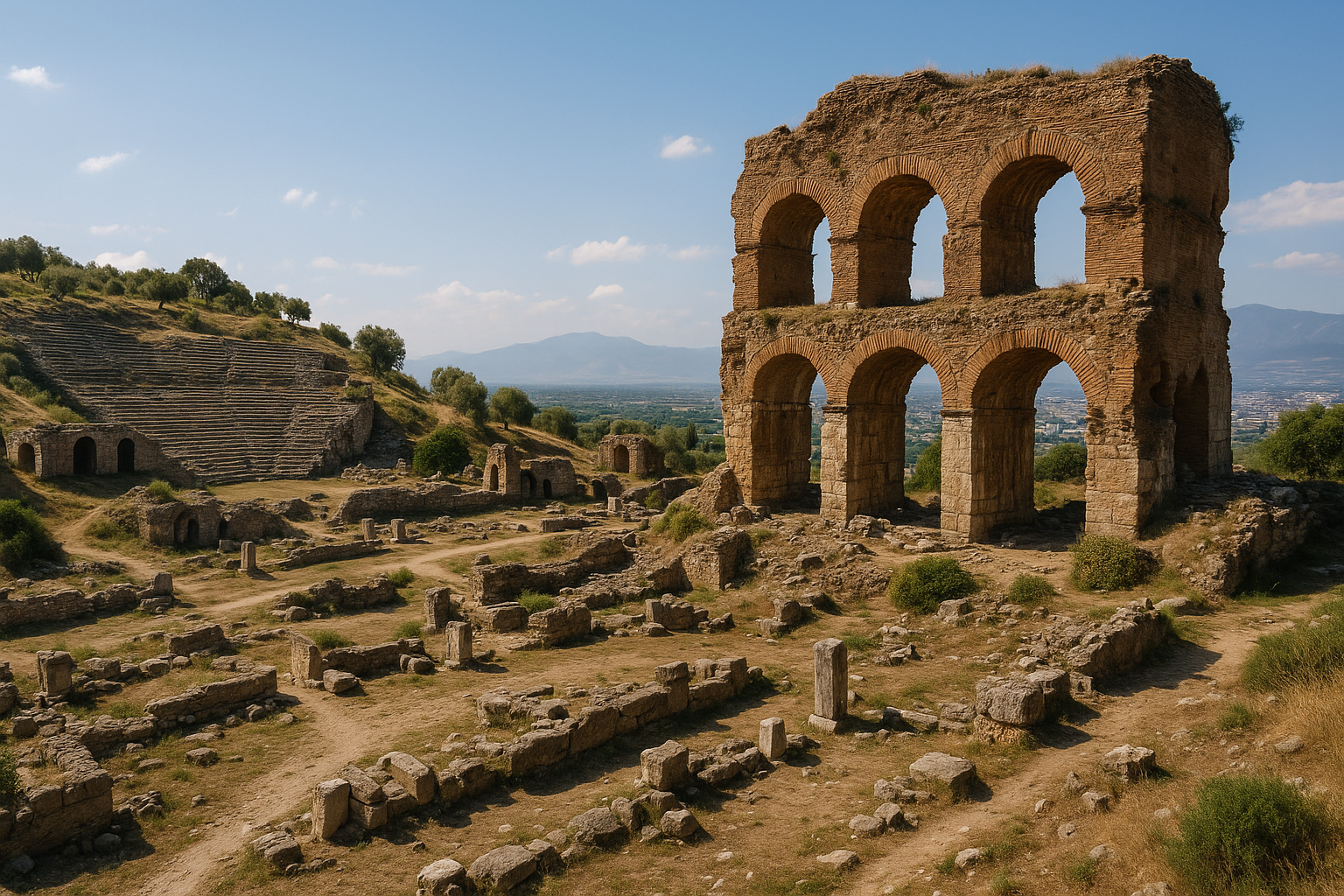
الحمّام-الجمنازيوم الروماني والقاعة الرخامية — الأناستيلوزيس
يهيمن مجمّع الحمّام-الجمنازيوم، على الجانب الشمالي من الطريق السريع الحديث، على المدينة السفلى. وهو من أكبر المجمّعات المعروفة من آسيا الصغرى الرومانية ومن القليل جدًا في أيّ مكان التي أُعيد بناؤها بشكل كبير.
يتكوّن المجمّع من ثلاثة عناصر رئيسية:
- بالايسترا كبيرة مفتوحة في الشرق، محاطة بأروقة على الجوانب الأربعة للتمرين والتدريب الرياضي؛
- شاشة ضخمة من طابقين من الأعمدة والكوّات والكورنيش — القاعة الرخامية — في الوسط، تفتح من البالايسترا إلى كتلة الحمّام؛
- كتلة الحمّام المقبّبة في الغرب، مع الفريجيداريوم والتيبيداريوم والكالداريوم مرتّبة على النمط الروماني المعياري.
أُكملت القاعة الرخامية في أوائل القرن الثالث الميلادي (يذكر النقش التكريسي كاراكلا وغيتا ويؤرّخ بعام 211/212 م)، وهي مثال فخم على ما يُسمّى "الأسلوب الرخامي" لآسيا الصغرى السيفيرية — كلّ سطح ظاهر مكسوّ بالرخام الملوّن، وكلّ تاج عمود محفور بعمق بأوراق الأقنثا، وكلّ كوّة متوّجة بأطر مزخرفة مثلّثة ومنحنية بالتناوب.
من 1964 فصاعدًا، اضطلع فريق هارفارد–كورنيل، تحت قيادة جورج هانفمان والمعماري أندرو سيغر، بـالأناستيلوزيس الرسمية للقاعة الرخامية — فرز الكتل الساقطة، وتحديد مواضعها الأصلية، وإعادة رفعها على القاعدة الأصلية بأقل قدر من التدخّل الحديث. النتيجة، المكتملة عام 1973 والمصقولة منذ ذلك الحين، هي أحد أكثر المشاهد إثارة في إيجة: قاعة سيفيرية مُعاد رفعها بالكامل، طابقان من الأعمدة والكوّات يرتفعان من الرصيف القديم، الأثر الوحيد من نوعه المُعاد إكماله في تركيا.
الكنيس (القرن 3–4 م)
داخل الجناح الجنوبي للحمّام-الجمنازيوم، شاغلًا حيّزًا بُني أصلًا كبازيليكا مدنية، يقع أكبر كنيس قديم معروف في العالم الروماني. اكتُشف عام 1962 ونُقّب طوال الستينيات، ويبلغ قياسه داخليًا نحو 60 × 18 مترًا وكان سيستوعب نحو ألف مصلٍّ.
الداخل مرتّب كقاعة طويلة ذات حنية مع:
- خزانة التوراة في كوّتين عند الطرف الشرقي (المدخل)، تؤطّر الباب؛
- مائدة رخامية مركزية كبيرة مع دعامات على شكل النسور الرومانية، تُستخدم للقراءة العامّة للأسفار المقدسة؛
- بيما مدرّجة في الحنية الغربية، يترأّس منها شيخ الجماعة؛
- أرضيات مرصوفة بـفسيفساء هندسية متقنة بقطع حمراء وبيضاء وزرقاء وخضراء؛
- جدران مكسوّة بكسوة رخامية مع لوحات نقوش للمتبرّعين.
أكثر من 80 نقش يوناني و7 نقوش عبرية للمتبرّعين تذكر أعضاء الجماعة. عدّة متبرّعين يحملون ألقاب بوليتيس (مواطن) وبوليفتيس (عضو مجلس المدينة) — دليل على أنّ الجماعة اليهودية في ساردس العصور القديمة المتأخرة كانت مندمجة على أعلى المستويات المدنية، تمتلك العقارات، تدفع للأعمال العامة، وتجلس في مجلس المدينة إلى جانب جيرانها الوثنيين والمسيحيين. دُمّر الكنيس في النهب الساساني عام 616 م ولم يُعَد بناؤه أبدًا.
البولوتيريون
تمّ تحديد قاعة مجلس روماني صغيرة في المدينة السفلى، غرب الحمّام-الجمنازيوم. يحفظ المبنى صفوف الجلوس المنحنية ويشير إلى استمرار حيوية الحكم الذاتي البلدي حتى القرن الثالث الميلادي.
المنازل الرومانية وتنقيبات القسم الليدي
القسم الليدي — منطقة مطبّقة على طول باكتولوس جنوب الطريق السريع — كان موقع عقود من التنقيب الدقيق التي أنتجت أوضح تسلسل طبقي للمدينة: منازل وورش ليديّة في القاعدة؛ طبقة الدمار من 547 ق.م المتميّزة بطوب طيني محروق وسقوف منهارة؛ إعادة بناء فارسية وهلنستية ورومانية فوقها. فوق المستويات الرومانية يقع صفّ من حوانيت رومانية متأخرة صغيرة على طول شارع معمّد، يحفظ كلّ منها عتبته وطاولة بيعه ومستلزمات التجزئة اليومية الصغيرة.
البازيليكا البيزنطية M والكنيسة EA
نُقّبت كنيستان بيزنطيتان رئيسيتان. البازيليكا M (تُسمّى أحيانًا الكنيسة M، بحسب حرف شبكة التيمينوس الرومانية)، الكنيسة الصغيرة الملحقة بالزاوية الجنوبية الشرقية لمعبد أرتميس، ذُكرت أعلاه. الكنيسة EA، قرب الجمنازيوم-الكنيس، بازيليكا ثلاثية الأروقة من القرن السادس مع مَعمودية، تشهد على استمرار حياة الجماعة المسيحية بعد الكارثة الساسانية.
الأنفاق الفارسية والهلنستية
تحت الأكروبوليس وفي نقاط حول المدينة السفلى، تتبّع علماء الآثار أنظمة أنفاق معقدة — قنوات إمداد بالمياه، ومنافذ للهجوم، وما قد يكون أعمال نقب للحصار. الأكبر، قرب الجمنازيوم، يمتدّ تحت الأرض لأكثر من 100 متر ويتنفّس عبر فتحات صغيرة إلى السطح. تأريخها الدقيق موضع جدل: بعضها يبدو ليديًا، وأخرى هلنستية، وعدّة منها يبدو أنّها كُيِّفت عبر فترات لاستخدامات مختلفة.
جدران الأكروبوليس
جدار مدينة ضخم ليديّ-فارسي بسماكة 20 مترًا عند القاعدة، مبنيّ من الطوب الطيني على قاعدة حجرية، تمّ تتبّعه لأكثر من 100 متر على الاقتراب الشرقي للمدينة السفلى. دُمّر في الهجوم الفارسي عام 547 ق.م وطبقة الحرق على طول قاعدته علامة طبقية رئيسية للمدينة بأكملها. أعلى، تحفظ الأكروبوليس ذاتها مراحل تحصين متعاقبة من الليديّ حتى البيزنطي، بأسلوب بناء مختلف بصريًا لكلّ فترة.
"بن تبه": مقبرة الملوك الليديين وتومولوس أليّاتيس
على بُعد سبعة كيلومترات شمال ساردس، عبر غديز على السلسلة المنخفضة بين النهر وبحيرة مرمرة (جيجايا)، تقع بن تبه — حرفيًا "آلاف التلال" — المقبرة الملكية للملوك الليديين. أكثر من مئة تومولوس مرئية عبر نحو اثني عشر كيلومترًا مربعًا من المناطق الريفية المتموّجة المنخفضة.
الأكبر هو تومولوس أليّاتيس، الذي قال هيرودوت إنّ الليديين اعتبروه أعظم آثارهم بعد أعمال المصريين والبابليين. يبلغ قطره نحو 360 مترًا وارتفاعه 60–70 مترًا — أكبر تومولوس في الأناضول ومن أكبر التوموليّات في العالم القديم، بحجم ردم مقدّر بأكثر من مليونَي متر مكعّب. يصف هيرودوت الأثر بالتفصيل (1.93): بُني تلّ الدفن من قِبَل مومسات ساردس والتجّار والحرفيين، وكان لكلّ مجموعة منهم أحجار حدود منقوشة حول القاعدة تسجّل مساهمتها؛ ويقول إنّ حصّة المومسات كانت الأكبر. غرفة الدفن في الداخل، من كتل حجر جيري مقطوع بسقف ناتئ ومدخل دروموس، نُهبت في العصور القديمة وأُعيد تحديدها على يد هاينريش شبيغلتال عام 1853؛ ويمكن أحيانًا زيارة نفق المدخل بترتيب خاصّ مع متحف مانيسا. تقعان قربها تومولوسان ضخمتان أخريان، تُحدّدان تقليديًا بـجيجيس وملك ثالث غير محدّد، وعشرات التلال الأصغر عبر الحقل تنتمي على الأرجح إلى النبلاء الليديين والعائلات المرزبانية في العصر الفارسي. بدأ المسح الجيوفيزيائي والليدار الأخير من قبل بعثة ساردس في رسم خريطة المقبرة كمشهد ملكي متماسك، ووثّق مشروع مواز مجموعة التوموليّات الأصغر التي تقع داخل المدينة السفلى ذاتها.
الشارع المعمّد للمدينة السفلى والحوانيت
يجري شرقًا-غربًا عبر المدينة السفلى، جنوب الحمّام-الجمنازيوم مباشرة، شارع روماني معمّد طويل نُقّب في مواسم متعاقبة منذ الستينيات. على طول جانبه الجنوبي يقف صفّ ملحوظ من نحو ثلاثين حانوتًا رومانيًا متأخرًا (القرن 4–7 م)، يفتح كلّ منها على الرواق ويحفظ العتبة، ومنطقة التخزين الخلفية، وآثار التركيب. تحدّد النقوش والمكتشفات الصغيرة عدّة من أصحاب الحوانيت — بعضهم يهود (يقع الكنيس على بُعد أمتار قليلة شمالًا)، وبعضهم مسيحيون، وبعضهم وثنيون — وتُظهر أنّ الحرف المماَرسة شملت الزجاجيات، والصباغة، وخلط الأصباغ، والحدادة، وبيع الطعام. دُمّرت الحوانيت في النهب الساساني عام 616 م، وتحفظ طبقة الدمار المحروق لقطة غنية بشكل غير معتاد للتجارة الحضرية في العصور القديمة المتأخرة.
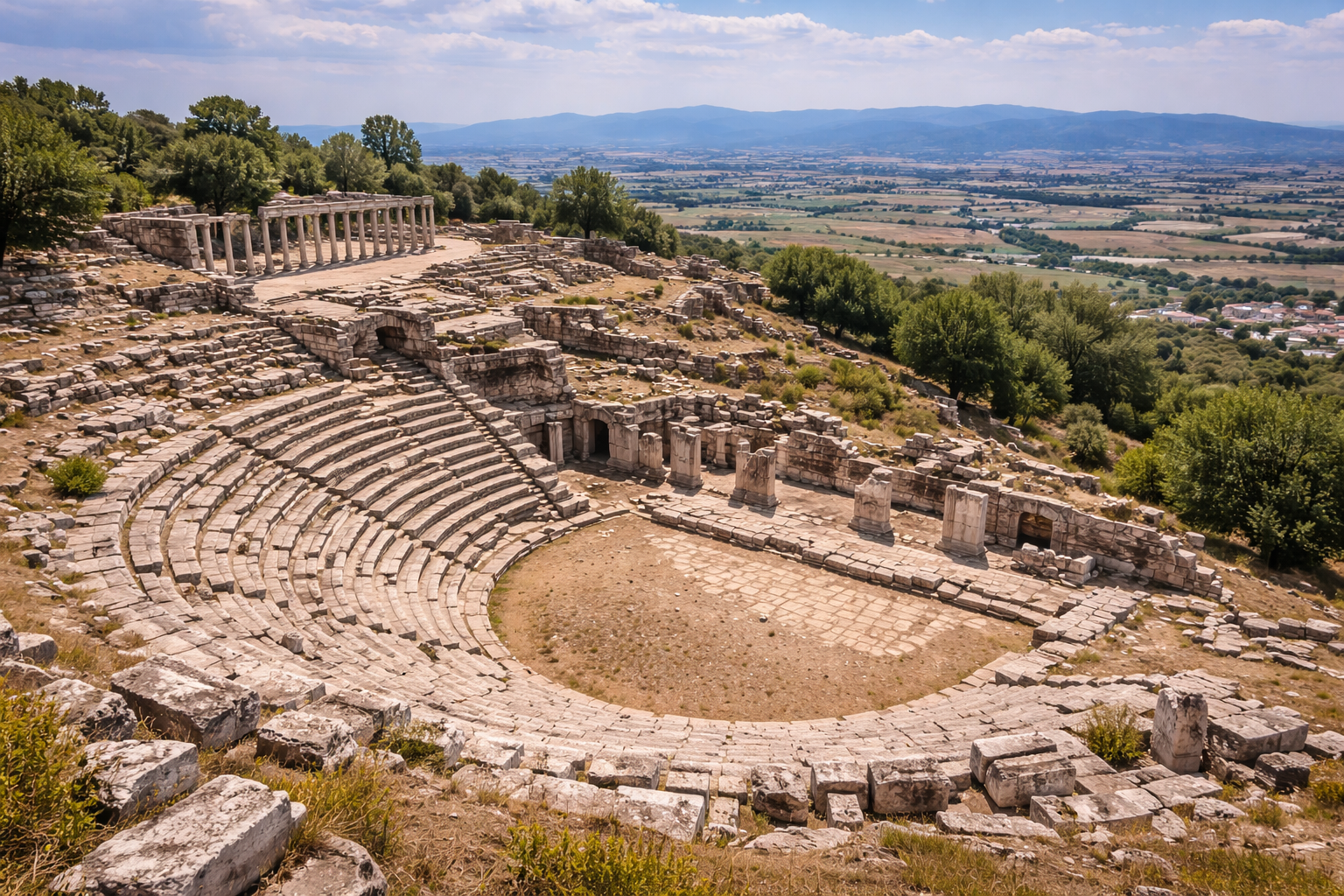
الستاديوم والمسرح
مسرح وستاديوم من الفترة الرومانية معروفان على المنحدرات الشمالية السفلى للأكروبوليس، لكن لم يُنقّب أيّ منهما بالكامل. كافيا المسرح مقطوعة جزئيًا في المنحدر ومبنية جزئيًا؛ ويقع الستاديوم في السرج بين المسرح والحمّام-الجمنازيوم ويمكن تتبّعه كمنخفض طويل في الحقول الحديثة. كلاهما مرئيان من الطريق السريع لكن لا يمكن زيارتهما حاليًا.
"بيت البرونزات" في ساردس
منطقة تنقيب موحية بشكل خاصّ، "بيت البرونزات"، هي مسكن روماني متأخر دُمّر في حريق مفاجئ ويحفظ مجموعة ملفتة من الأواني البرونزية (أحواض، حوامل سُرج، أباريق) تركها أصحابها وهم يفرّون. نقوش وقرائن صغيرة قابلة للتأريخ تضع الدمار في أوائل القرن السابع الميلادي — أي في الهجوم الساساني — والمجموعة من أكثر مجموعات البرونز المحلّي القديم المتأخر تماسكًا التي نُقّبت حتى الآن في أيّ مكان في آسيا الصغرى.
اختراع سكّ النقود
الشيء الأكثر تأثيرًا الذي حدث في ساردس حدث في وقت ما في أواخر القرن السابع ق.م، على الأرجح تحت أليّاتيس، حين أخذ شخص ما في البلاط الليدي كتلة صغيرة من الإلكتروم المكرّر، وأسقطها على قالب، وضربها بمطرقة، وأنتج جسمًا قيمته مضمونة من المُصدِر. من الصعب المبالغة في كمّ كان هذا تحويليًا، أو في كمّ يقوم العالم الحديث مباشرة عليه.
لماذا النقود، ولماذا هنا؟
تجمّعت ثلاثة شروط مسبقة في ساردس وتقريبًا في أيّ مكان آخر من العالم القديم.
- المادة. أنتج باكتولوس إلكترومًا خامًا بكميات غير عادية، متاحًا فورًا للورش الملكية عند سفح الأكروبوليس.
- السلطة السياسية. كانت الدولة الليديّة مركزية وثرية بما يكفي لفرض معيار موحّد، وملاحقة المزوّرين، وقبول عملاتها الخاصة في دفع الضرائب.
- الطلب التجاري. كانت الأغورا — البازار التجاري الكثيف الذي يقول هيرودوت إنّ الليديين كانوا روّاده — تحتاج إلى وسيط تبادل أكثر عملية من السبائك الموزونة. كان التجار الأناضوليون واليونانيون يتاجرون بأحجام عالية بما يكفي ليصبح إزعاج وزن كتل المعدن لكلّ معاملة حقيقيًا.
أقدم العملات
الإصدارات الأولى، المؤرّخة طبقيًا تحت أساسات معبد أرتميس في أفسس بنحو 630–600 ق.م، هي كتل إلكتروم صغيرة مطبوعة على وجه برأس أسد مزمجر وعلى الآخر بعلامات المطرقة الخام لحامل القالب. هي مجهولة — لا يظهر اسم ملك — لكنّ الأسد هو الشعار الملكي الموثّق جيدًا لبيت المرمناد. تتدرّج الفئات من الستاتر الكامل (نحو 14 غ) عبر الهيكستي (السدس)، والثامن، والثاني عشر، والرابع والعشرين، وهكذا حتى كسور أقلّ من عُشر غرام، أصغر من قُلامة ظفر حديثة. هذا النطاق الواسع من الفئات مهم في حدّ ذاته: يُظهر أنّ النظام الجديد كان مُعدًّا للتجارة اليومية بالتجزئة، لا للمدفوعات الحكومية الكبيرة فقط.
أيقونة "الأسد الليدي"
الأسد المزمجر للعملات الليدية أحد أنجح قطع العلامات التجارية الحكومية التي ابتُكرت على الإطلاق. ظهرت الصورة ذاتها لجيلين على الأختام الليدية والعاجيات والزخارف المعمارية، وكانت الشعار المعروف جيدًا للسلالة. تضيف الإصدارات اللاحقة رأس ثور، و(تحت كرويسوس) الرأسين المتقابلين لأسد وثور معًا — رموز للقوة والخصوبة، للسلطة الملكية والرفاه.
تركيبة موحّدة
أظهر التحليل التركيبي الحديث من قبل المتحف البريطاني وبعثة ساردس أنّ الإلكتروم المستخدم كان مسبوكًا عمدًا وباستمرار إلى حوالي 55% ذهب، 45% فضة، بعيدًا تمامًا عن المحتوى الذهبي الأعلى للإلكتروم الغريني الطبيعي لباكتولوس (الذي يتراوح من 70% إلى 83% ذهب). الليديون، بعبارة أخرى، لم يكونوا يطبعون ببساطة المعدن الموجود؛ كانوا يكرّرونه، ويعدّلون السبيكة، ثمّ يطبعونه على معيار محدّد. هذه هي أقدم حالة موثّقة للتحكّم النقدي للدولة — اللحظة التي بدأت فيها قيمة قطعة معدنية تستمدّ من سلطة مُصدِرها لا من وزن ونقاء مادتها فحسب.
نظام كرويسوس الثنائي المعدن: الكرويسيدات
كان ابتكار كرويسوس العظيم، حوالي منتصف القرن السادس ق.م، التخلّي عن الإلكتروم تمامًا لصالح عملات منفصلة من الذهب الخالص والفضة الخالصة — ما يُسمّى الكرويسيدات — مضروبة على معيار وزن مشترك بحيث يمكن ضمان نسبة صرف ثابتة (عادة 13⅓ إلى 1).
- الـستاتر الذهبي يزن نحو 10.7 غ.
- الـستاتر الفضي يزن نحو 10.7 غ.
- ضُربت فئات أصغر من كلّ منهما بالتناسب.
كانت هذه أوّل عملة ثنائية المعدن في العالم. لإنتاجها تطلّب مصفاة التسميت على باكتولوس، إذ لم يكن من الممكن ببساطة غربلة الذهب الخالص والفضة الخالصة من الجدول. كان يجب فصل المعدنين كيميائيًا، وهو ما فعله الميتالورجيون الليديون بتسخين الإلكتروم مع الملح في أوانٍ فخارية مغطّاة عند 600–800 °م — عملية تُعرف الآن بالتسميت، يهاجم فيها الكلور المتحرّر من الملح المسخّن الفضة لكن يترك الذهب سليمًا.
الأثر العالمي للعملة
انتشرت الفكرة بسرعة مذهلة. بحلول أواخر القرن السادس ق.م، كانت كلّ مدينة يونانية كبرى — إيجينا، أثينا، كورنث، خالكيس، المدن الأيونية، مستعمرات البحر الأسود — تسكّ عملتها الفضية الخاصة. بحلول أواخر القرن الخامس، كان الفرس قد وحّدوا النظام الليدي إلى الداريك على مستوى الإمبراطورية (ذهب، نحو 8.4 غ) والسيغلوس (فضة، نحو 5.6 غ)، كلاهما مسكوكان في ساردس كما في الولايات الشرقية. تبنّى القرطاجيون السكّ على النمط اليوناني خلال حروبهم في صقلية؛ بدأ الرومان سكّ البرونز في القرن الرابع ق.م والفضة بعد ذلك بقليل. تبنّى الأباطرة الماوريون في الهند العملات الفضية المضروبة بعلامات الوخز. بحلول عصر أوغسطس، كان كامل العالم المتوسطي والشرق الأدنى يعمل على نقد مسكوك.
العملات الحديثة — الدولار، اليورو، الليرة، اليوان — هي أحفاد بعيدون في سلسلة متّصلة من الممارسة النقدية تبدأ في ساردس تحت أليّاتيس وكرويسوس.
السكّ والتحوّل الاجتماعي الذي جلبه
ما كان ثوريًا في السكّ ليس المعدن بل العُرف. العملة هي قطعة معدنية قيمتها مضمونة ليس بنقائها (الذي يصعب تقييمه على العين غير المدرّبة) بل بسلطة مُصدِرها. قبول عملة يتطلّب إذًا قبول سلطة الدولة التي ضربتها؛ رفض قبولها يساوي معارضة سياسية. بهذا المعنى، كان الاختراع الليدي عملًا سياسيًا بقدر ما كان عملًا اقتصاديًا. حقيقة أنّ السلطة الحكومية الليدية كانت قوية بما يكفي، في أواخر القرن السابع ق.م، لإقرار مثل هذا العُرف — لجعل قطعة إلكتروم موزونة بشكل خاصّ أقلّ جاذبية من عملة رسمية مدبَّسة قليلًا بنفس الوزن الاسمي — هي في حدّ ذاتها مقياس لنضج دولة المرمناد.
في غضون جيل من الإصدارات الأولى، بدأ النقد المسكوك يتغلغل في كلّ مستوى من المجتمع الليدي والأيوني. أصغر الكسور الإلكترومية — قطع تزن أقلّ من 0.16 غ — لا بدّ أنّها استُخدمت لمعاملات السوق اليومية، بمثابة الصرف الصغير. الأجور، أسعار السوق، بيع العبيد، المهور، الغرامات، الضرائب: كلّ فئات المعاملات النقدية المسجّلة في نقوش أثينا في القرن الخامس مرئية في الجنين في ساردس في القرن السادس. تحوّل عميق في كيفية تصوّر القيمة ذاتها — من المادة إلى الرمز، من الوزن إلى السلطة، من المادة إلى العلاقة — بدأ هنا.
أين توجد أوّل العملات الليدية اليوم
المجموعات الحديثة للعملات الليدية متناثرة، لكن أكبر الحيازات في:
- المتحف البريطاني، مع سلاسل رئيسية استُحوذ عليها في القرن التاسع عشر؛
- الجمعية العددية الأمريكية في نيويورك؛
- متحف مانيسا، مع المكتشفات من تنقيبات ساردس ذاتها؛
- المكتبة الوطنية الفرنسية (خزانة الميداليات) في باريس؛
- متحف العملات في برلين؛
- متحف اسطنبول الأثري.
حفنة من "القطع التجريبية" — كتل إلكتروم ذات وجه واحد مطبوعة فقط بصورة رأس الأسد على الوجه وتفتقر إلى مطرقة ظهر متطوّرة بشكل صحيح — يُعتقد أنّها من بين أقدم الإصدارات بالفعل وهي مقدّرة بشكل خاصّ من قبل علماء النقود.
كرويسوس وحكايات هيرودوت
لم يترك أيّ ملك أناضولي آخر بصمة بهذا العمق على الأدب اليوناني كما فعل كرويسوس، ومعظم ما نظنّ أنّنا نعرفه عنه يأتي من هيرودوت، الذي خصّص قرابة نصف الكتاب الأوّل من التواريخ لصعود وسقوط البيت الليدي. الحكايات هي جزئيًا تاريخ، وجزئيًا قصة أخلاقية، وجزئيًا تقليد القصر الليدي مُرشَّحًا عبر القصص الأيونية. تُقرأ اليوم كنصوص تأسيسية للسرد التاريخي — لكنّها أيضًا روائع قصصية قصيرة، وكان هيرودوت يعرف ذلك.
صولون في ساردس
يحكي هيرودوت كيف جاء صولون، المشرّع الأثيني، إلى بلاط كرويسوس في ساردس في رحلات العشر سنوات التي اضطلع بها بعد إصدار دستوره. عرض الملك خزانته ورخاء مدينته ثمّ، واثقًا من الجواب، سأل صولون من هو أسعد رجل في العالم.
ذكر صولون أوّلًا الأثيني تيلوس، الذي عاش في مدينة مزدهرة، وربّى أبناءً صالحين ربّوا بدورهم أحفادًا صالحين، ومات بشرف في معركة دفاعًا عن مدينته. عند الإلحاح، ذكر صولون في المرتبة الثانية الأخوين كليوبيس وبيتون، اللذين رَبَطا نفسيهما في عربة لجرّ والدتهما (كاهنة هيرا) خمسة أميال إلى مهرجانها حين فشل الثيران في الوصول في الوقت المحدّد، وبعد ذلك استلقيا في المعبد ولم يستيقظا أبدًا — موت منحته الإلهة كأكمل هدية لتكريم تقواهما.
أهين كرويسوس، الذي توقّع اسمه. ردّ صولون بأحد أشهر النقوش في الفكر اليوناني:
"لا تُعدّ أيّ رجل سعيدًا حتى يموت."
أوضح صولون أنّ الثروة والقوة هي هدايا الحظّ، والحظّ متقلّب. لا يمكن وصف الحياة بالسعادة إلّا حين تكتمل، بعيدة عن متناول مزيد من التغيير.
حلم أتيس
كرويسوس، إذ توقّع في حلم الموت العنيف لابنه أتيس، حبس الصبيّ بعيدًا عن الأسلحة ورفض السماح له بالصيد. حين توسّل رجال ميسيا المساعدة ضدّ خنزير بريّ وحشي يدمّر محاصيلهم، رضخ كرويسوس وأرسل ابنه في الصيد مع حارس شخصي. ضيف في البلاط، الفريجي أدراستوس — وهو نفسه فارّ بعد قتل أخ بالخطأ، وكان كرويسوس قد طهّره وآواه — أُوكلت إليه رعايته. في المطاردة، أخطأ رمح أدراستوس الخنزير وضرب أتيس فقتله على الفور. عند العودة إلى ساردس، قتل أدراستوس نفسه على قبر الصبيّ. تكمن القوة الأخلاقية للحكاية في استحالة التهرّب ممّا هو مقدَّر، وفي السخرية المرّة التي بها أثبتت الاحتياطات ذاتها التي اتّخذها كرويسوس أنّها وسيلة التحقّق.
وحي دلفي
اختبر كرويسوس العرافات اليونانية بإرسال سفارات كانت، في يوم محدّد بدقة بعد مئة يوم من مغادرتها، أن تسأل كلّ معبد ماذا يفعل الملك في تلك اللحظة. دلفي فقط أجابت بصورة صحيحة — أنّ الملك كان يطبخ سلحفاة وحملًا معًا في قِدر برونزي بغطاء برونزي (قائمة طعام غريبة عمدًا مختارة لهزيمة أيّ تخمين).
اقتنع كرويسوس، فأرسل تكريسات مذهلة إلى دلفي: أسد ذهبي يزن عشرة وزنات، وأطباق ذهبية وأوعية خلط فضية، وتمثال ذهب وفضة لخبّازة، ومجوهرات ملكته الخاصة. نجا بعض منها في دلفي لقرون — يذكرها بوسانياس بعد خمسمئة سنة.
ثمّ استشار العرّافة عمّا إذا كان يجب مهاجمة فارس فقيل له:
"إن عبرت هاليس، فستدمّر إمبراطورية عظيمة."
تشجّع كرويسوس، فعبر هاليس. الإمبراطورية التي دمّرها كانت إمبراطوريته.
نار كيبيلي
أسطورة منفصلة، يسجّلها هيرودوت وكتّاب آخرون، تتعلّق بحرق ساردس عام 499 ق.م. أشعل اليونانيون النار — عرضًا — في بيت ذي سقف قصبي في المدينة السفلى المبنية بكثافة؛ انتشرت النار إلى معبد كيبيلي، الإلهة الأمّ لليديين والفريجيين، وأحرقته. الفرس، يقول هيرودوت، استخدموا هذا التدنيس كمبرّر رسمي لحرق المعابد اليونانية انتقامًا خلال غزوات خشايارشا، بما في ذلك معابد أكروبوليس أثينا عام 480 ق.م.
القصة حالة صغيرة لكن كاشفة لكيف أصبحت حادثة محلية في ساردس، في الذاكرة الإمبراطورية الفارسية، مظلمة محدِّدة.
المحرقة
حين أخذ قورش ساردس عام 547 ق.م، وُضع كرويسوس مقيّدًا على محرقة كبيرة من الخشب — سواء كقربان أو عقوبة أو اختبار، هيرودوت غير متيقّن. في آخر لحظة، حين أُشعل الخشب، نادى كرويسوس باسم صولون ثلاث مرّات. فضولًا، أمر قورش بإنزاله واستجوابه. عند سماع الحوار في الخزانة في ساردس، تأمّل قورش في انعكاس الحظوظ وأمر بإطفاء المحرقة.
لكنّ الخشب كان قد اشتعل؛ تمسّك اللهب. عاصفة مطرية مفاجئة فقط — أرسلها أبولو استجابة لصلاة كرويسوس — أطفأتها. أمضى كرويسوس بقية حياته كمستشار مكرّم في البلاط الفارسي، مع قورش ثمّ قمبيز، ويظهر في التواريخ كنوع من الجوقة الفلسفية، يعلّق على صعود وسقوط الملوك.
هذه القصص ليست تاريخًا بالمعنى الحديث الدقيق؛ إنّها الطريقة التي يفكّر بها اليونانيون الأوائل، عبر السرد، حول مخاطر الثروة، ولامبالاة الآلهة بسعادة البشر، وزَلَقية اللغة العرّافية. ساردس هي المسرح الذي تجري عليه، وكرويسوس الشخصية التي تقف نائبة عن المشكلة العالمية لكيفية العيش في عالم يمكن فيه أن يُؤخذ كلّ شيء.
قصص كرويسوس الأخرى التي حفظها هيرودوت
ما وراء المشاهد الشهيرة، يحفظ هيرودوت حفنة من القصص الأصغر التي تملأ نسيج الحياة في البلاط الليدي.
-
الجسر فوق هاليس. حين بلغ جيش كرويسوس هاليس (قِزِلَيرماك الحديث)، لم يكن هناك جسر، وكان النهر غير قابل للعبور. المهندس اليوناني طاليس الميليتي، الذي يقول هيرودوت إنّه كان في حاشية كرويسوس، حفر قناة حوّلت النهر إلى قناتين أقلّ عمقًا خلف موقع الجيش، ممّا سمح بعبور كلا الفرعين. يُعرب هيرودوت عن الشكّ لكنّه يسجّل القصة.
-
الابن الأبكم الذي تكلّم. كان لكرويسوس ابن ثانٍ بكم منذ الولادة. في فوضى الهجوم الفارسي على ساردس، كاد جندي لم يتعرّف عليه يقتل الملك، حين صرخ الابن الأبكم: "أيّها الجندي، لا تقتل كرويسوس!" — وجد صوته، يقول التواريخ، في غاية خطر والده. أيًا كانت قاعدته الواقعية، تلتقط الحكاية الافتتان اليوناني باندلاع الصوت واللغة في لحظات الأزمة.
-
نصيحة كرويسوس لقورش. بعد إنقاذه من المحرقة، أصبح كرويسوس مستشارًا لقورش. حين ثار الليديون ضدّ قورش بعد الفتح بفترة قصيرة، فكّر قورش في تدمير المدينة كليًا؛ أقنعه كرويسوس بدلًا من ذلك بنزع سلاح الليديين، ومنعهم من حمل السلاح، ومطالبتهم بإرسال أبنائهم لتعلّم الفنون الصغيرة من الموسيقى والرقص والتجارة بالتجزئة. في غضون جيل، جادل كرويسوس، سيصبح شعب أليّاتيس المحارب أمّة من أصحاب الحوانيت ولن يشكّل تهديدًا عسكريًا. تُروى القصة بازدراء يوناني واضح لما يُقال إنّ الليديين أصبحوا عليه.
تنتشر هذه الومضات في التقليد اليوناني بقوّة أخلاقية لا تتناسب مع ثقلها الواقعي: إنّها الطريقة التي علّم بها اليونانيون أنفسهم عن الإمبراطورية والقدر وهشاشة العظمة.
كنائس آسيا السبع
سفر الرؤيا (الفصلان 2 و3) يحفظ سبع رسائل أُمليت على يوحنا في بطمس وموجّهة إلى سبع جماعات مسيحية في غرب آسيا الصغرى: أفسس، سميرنا، بيرغامون، ثياتيرا، ساردس، فيلادلفيا، ولاودكية. كلّ رسالة تتّبع النمط البلاغي ذاته — تحيّة، قائمة بنقاط قوة الجماعة، قائمة بنقاط ضعفها، تحذير، وعد — لكنّ نبرتها تختلف بشكل دراماتيكي، من المدح الحذر لفيلادلفيا إلى التوبيخ الحارق للاودكية.
الرسالة إلى ساردس (الرؤيا 3:1–6) من أقسى السبع:
"أنا عارف أعمالك، أنّ لك اسمًا أنّك حيّ وأنت ميت. كن ساهرًا وشدّد ما بقي، الذي هو عتيد أن يموت، لأنّي لم أجد أعمالك كاملة أمام إلهي. فاذكر كيف أخذت وسمعت، واحفظ وتب. فإن لم تسهر، أقدم عليك كلصّ، ولا تعلم أيّة ساعة أقدم عليك. عندك أسماء قليلة في ساردس لم ينجّسوا ثيابهم، فسيمشون معي في ثياب بيض لأنّهم مستحقّون."
تعتمد القوة التاريخية للتوبيخ على لعب بكلمات على سمعة ساردس المدنية ذاتها. المدينة كانت قد أُخذت بالمفاجأة مرّتين في تاريخها عبر مراقبة غير كافية على الأكروبوليس — على يد قورش عام 547 ق.م، حين وجد متسلّق فارسي شقًّا غير محروس في الجرف بينما كان حارس نائمًا، وعلى يد أنطيوخس الثالث عام 215 ق.م، حين كرّر لاغوراس الكريتي الحيلة على وجه مختلف. كان كلّ ساردي في أواخر القرن الأول الميلادي يعرف هذه القصص. الدعوة إلى "السهر" وإلى تذكّر "كيف أخذت وسمعت" تنزل بثقل متعمّد على مدينة تعرف بالضبط ماذا يحدث حين ينام حرّاسها.
"الأسماء القليلة التي لم ينجّسوا ثيابهم" أصبحت، في التقليد اللاحق، النواة المؤمنة للكنيسة الساردية — أولئك الذين، في القرن الثاني، حملوها قُدمًا إلى عصر ميليتو.
ميليتو الساردي
أسقف القرن الثاني ميليتو الساردي من أهمّ الكتّاب المسيحيين في جيله. كتابه Peri Pascha — عن الفصح — أقدم عظة فصح مسيحية باقية وأحد النصوص التأسيسية للبلاغة المسيحية، مع ترتيل تعويذي طويل عن حمل الله شكّل الليتورجيا الشرقية منذ ذلك الحين. يحفظ يوسابيوس شذرات من أعماله الدفاعية واللاهوتية ويدرج أكثر من اثنتي عشرة رسالة مفقودة عن النبوءة والمعمودية والروزنامة الكنسية والتفسير الكتابي.
حضر ميليتو المجمع الذي أكّد قانون العهد القديم للكنيسة اليونانية المبكّرة؛ سافر إلى فلسطين للتحقّق من النصّ التوراتي اليهودي مقابل التقاليد العبرية المحلية؛ وكتب دفاعًا موجّهًا إلى الإمبراطور ماركوس أوريليوس يحجّ لتسامح المسيحية. حضوره في ساردس في ستينيات وسبعينيات القرن الثاني الميلادي يعني أنّ المدينة كانت مركزًا كبيرًا للحياة الفكرية المسيحية في الفترة بالضبط حين كان كنيسها اليهودي في أوجه. الجماعتان — اليهودية والمسيحية، كلتاهما مزدهرة وفصيحة — لا بدّ أنّهما عرفتا بعضهما البعض جيدًا، والحدّة الجدلية في Peri Pascha لميليتو ضدّ التفسيرات اليهودية للفصح تتّخذ بُعدًا محليًا حادًا في ذلك الضوء.
مسار الحجّ اليوم
ساردس محطّة منتظمة على حجّ الكنائس السبع الحديث، الذي يجري شمالًا من أفسس عبر سميرنا (إزمير الحديثة) وبيرغامون (بيرغاما) وثياتيرا (أكحصار) ثمّ جنوبًا عبر ساردس (سارت) وفيلادلفيا (آلاشهير) ولاودكية (قرب دنيزلي). يمكن قيادة المسار كاملًا في ثلاثة أو أربعة أيام من إزمير؛ تقدّم كثير من شركات السياحة هذا كحزمة سياحية. الزوّار ذوو التركيز الديني غالبًا ما يجمعون ساردس مع فيلادلفيا، التي تقع على بُعد 40 كم شرقًا فحسب صعودًا في وادي هيرموس ذاته.
العمل الأثري
كان علم الآثار الحديث في ساردس متواصلًا بشكل ملحوظ. حملتان كبيرتان — برينستون 1910–1914 وهارفارد–كورنيل من 1958 إلى الحاضر — أنتجتا أحد أعمق السجلّات الوثائقية لأيّ مدينة في تركيا.
الرحّالة الأوائل: تكسييه وهاميلتون
أُجري أوّل عمل طوبوغرافي جدّي في ساردس في ثلاثينيات وأربعينيات القرن التاسع عشر على يد المعماري الفرنسي شارل تكسييه والجيولوجي البريطاني ويليام هاميلتون. كلاهما رسما خططًا ومقاطع للهياكل الباقية وحدّدا المعالم الرئيسية. رسومات تكسييه للأعمدة القائمة لأرتميس، المنشورة في كتابه الكبير وصف آسيا الصغرى (1839–1849)، تبقى أقدم سجلّ مرئي دقيق للمعبد. كتاب هاميلتون الأبحاث في آسيا الصغرى (1842) وضع ساردس على خرائط الدراسات الكلاسيكية الفيكتورية.
في 1853، فتح هاينريش شبيغلتال، القنصل البروسي في سميرنا، غرفة الدفن لتومولوس أليّاتيس في بن تبه — أوّل تنقيب علمي لقبر ملكي ليدي.
هاوارد كروسبي بتلر (برينستون)، 1910–1914
أوّل تنقيب منهجي للمدينة وجّهه هاوارد كروسبي بتلر من برينستون، الذي ركّز على معبد أرتميس. في خمسة مواسم، نظّف فريقه المعبد حتى أساساته، وكشف العمودين القائمين بكامل ارتفاعهما، وتتبّع المنصّة، وأنتج المنشور الرائع من مجلّدين ساردس I: التنقيبات وساردس II: معبد أرتميس (1922–1925). فتح بتلر أيضًا أكثر من 1,100 قبر ليدي في المقابر حول المدينة واستعاد أساس تسلسل الفخار الليدي الذي لا يزال مستخدمًا اليوم. توقّف العمل عام 1914 بنشوب الحرب ولم يُستأنف أبدًا تحت إدارة برينستون؛ مات بتلر نفسه عام 1922، وورّث في النهاية فريق هارفارد–كورنيل ملاحظاته الميدانية غير المنشورة.
التوقّف بين الحربين، 1914–1958
خلال الحرب العالمية الأولى، والحرب اليونانية-التركية وحرب الاستقلال التركية، وتبادلات السكان في عشرينيات القرن العشرين، واضطرابات الثلاثينيات والحرب العالمية الثانية، لم يجرِ أيّ تنقيب كبير في ساردس. رقد الموقع هادئًا تحت كرومه. أصبح العمودان القائمان لمعبد أرتميس، في هذه الفترة، أحد الزخارف الفوتوغرافية الأيقونية للعصور القديمة الكلاسيكية "المفقودة".
جورج م. أ. هانفمان (هارفارد–كورنيل)، 1958–1976
بدأ العصر الحديث للعمل في ساردس عام 1958، حين أطلق جورج هانفمان من هارفارد وهنري ديتويلر من كورنيل استكشاف هارفارد–كورنيل الأثري لساردس — "بعثة ساردس". كانت رؤية هانفمان واسعة عمدًا: المدينة في كلّ فتراتها، المدينة السفلى بقدر الأكروبوليس، الحياة اليومية للحرفيين وأصحاب الحوانيت بقدر المعالم الكبرى.
تحت إدارته اكتُشف مجمّع الجمنازيوم-الكنيس (1962)، وحُدّدت مصفاة الذهب (1968)، وأُعيد بناء القاعة الرخامية بالأناستيلوزيس (1964 فصاعدًا)، وأُسّس التسلسل الطبقي الليدي على باكتولوس بحزم لأوّل مرّة. يبقى كتابه ساردس من العصور ما قبل التاريخية إلى الرومانية (هارفارد، 1983) المرجع المعياري من مجلّد واحد. رسائل هانفمان من الميدان، المنشورة بعنوان رسائل من ساردس (1972)، هي أيضًا كلاسيكية لعلم الآثار الميداني في منتصف القرن العشرين — مضحكة، حادّة الملاحظة، كريمة عن الزملاء، وغنية بالمعلومات عن كلّ جانب من إدارة حفر طويل الأمد في قرية تركية صغيرة.
كروفورد ه. غرينيوولت الابن (جامعة كاليفورنيا، بيركلي)، 1976–2007
عند تقاعد هانفمان، انتقلت الإدارة إلى كروفورد "غريني" غرينيوولت الابن من جامعة كاليفورنيا، بيركلي. على مدى واحد وثلاثين موسمًا سنويًا، قاد غرينيوولت تنقيب جدار التحصين الليدي العظيم، والورش على طول باكتولوس، وطبقة الدمار الليدي من 547 ق.م، والمصاطب السكنية على المنحدر الشمالي للأكروبوليس. اشتُهر بأسلوبه الميداني المتأنّي بشكل غير عادي (كلّ شظية مسجّلة، كلّ تغيير في التربة مرسوم)، ونشره الصبور على مدى عقود للمواد الليدية، وإرشاده الوثيق، شبه الأبوي، لجيلين من علماء الآثار الأصغر سنًا. مات غرينيوولت عام 2012، بعد أن رأى المشروع آمنًا عبر انتقاله الجيلي الكبير الثاني.
نيكولاس د. كاهيل (جامعة ويسكونسن–ماديسون)، 2008 حتى الحاضر
منذ 2008، يوجّه المشروع نيكولاس كاهيل من جامعة ويسكونسن–ماديسون. العمل الرئيسي الأخير يشمل الحملة الطويلة لتنقيب ساحة الحرَم في المدينة السفلى (مشروع تطلّب خمسة عشر عامًا من المواسم المتراكمة)، والتحقيق الإضافي في جدار التحصين الليدي، ونشر المنازل والفخار الليديّ في تقرير ساردس 4 (2010)، والصيانة طويلة الأمد لفسيفساء الكنيس، التي عانت من تلف الصقيع وغزو الجذور منذ تعرّضها الأوّل.
ركّز المشروع تحت كاهيل أيضًا بشكل غير عادي على الآثار العامّة والوصول المفتوح: موقع المشروع، sardisexpedition.org، يستضيف السلسلة الكاملة من تقارير ساردس وأطروحاتها، والصور الميدانية، والخطط الرقمية، كلّها متاحة مجانًا. في 2024 أُضيف الموقع إلى القائمة التمهيدية للتراث العالمي لليونسكو، مع الترشيح الكامل قيد التحضير.
منشورات بعثة ساردس
تنشر البعثة نتائجها في سلسلتين رئيسيتين:
- تقارير ساردس — أطروحات عن المناطق المنقّبة والمعالم، تبدأ بـتقرير ساردس 1: الكنز الليدي (1965) وتعدّ الآن أكثر من اثني عشر مجلّدًا تغطّي الكنيس والحمّام-الجمنازيوم والمنازل الليدية والاستيطان ما قبل التاريخي والبروتو-تاريخي والمعالم الفردية؛
- أطروحات ساردس — تعالج فئات محدّدة من المواد عبر الموقع بأكمله، بما في ذلك العملات (بيتس 1971)، والمصابيح (كروفورد 1990)، والنحت (هانفمان وراماج 1978)، والنقوش (بكلر وروبنسون 1932، محدّثة منذ ذلك الحين).
بالإضافة إلى هذه السلاسل الرسمية، تنشر البعثة تقارير سنوية في كازي سونوتشلاري توبلانتيسي ومقالات علمية أقصر في مجلّات مثل المجلة الأمريكية لعلم الآثار والدراسات الأناضولية.
الحفظ والعرض
موضوع طويل الأمد للمشروع كان الحفظ بقدر الاكتشاف. يبقى أناستيلوزيس القاعة الرخامية الإنجاز الأكثر وضوحًا للمشروع، لكنّه واحد فقط من جهود حفظ كثيرة. رُفعت فسيفساء الكنيس، وتمّ تثبيتها، وأُعيد وضعها؛ ورُصدت أعمدة المعبد القائمة من أجل الحركة؛ وأُويت الحيّ الحرفي الليدي تحت أغطية حديثة؛ وأُعيد تسقيف الحوانيت المعمّدة. درّب المشروع أجيالًا من المرمّمين الأتراك إلى جانب اختصاصييه الأمريكيين والأوروبيين، والتقنيات المطوّرة في ساردس — لا سيّما لتثبيت الطوب الطيني ولرفع وإعادة وضع سطوح فسيفسائية كبيرة — صُدّرت إلى مواقع أخرى عبر غرب الأناضول.
المشروع كنموذج
تُستشهد ساردس على نطاق واسع في الانضباط كنموذج لكيفية تنظيم ونشر مشروع تنقيب طويل الأمد. نشرت البعثة باستمرار، وحافظت على علاقات عمل وثيقة مع السلطات التركية والمجتمعات المحلية، ودرّبت أجيالًا من الطلاب، وفتحت تدريجيًا أرشيفاتها. قليلة هي المشاريع الأمريكية في الخارج التي امتدّت لهذه المدة أو أنتجت بهذه الإنتاجية.
الأرقام والقياسات
| الموضوع | القياس | الفترة / الملاحظات |
|---|---|---|
| ارتفاع الموقع، المدينة السفلى | نحو 110 م فوق مستوى سطح البحر | — |
| قمّة الأكروبوليس | نحو 410 م فوق مستوى سطح البحر | نحو 300 م فوق أرضية الوادي |
| قمّة جبل تمولوس (بوزداغ) | 2,159 م | أعلى قمّة في السلسلة المباشرة |
| المسافة من مركز مدينة إزمير | 90 km شرقًا | عبر طريق E96/D300 السريع |
| المسافة من صاليحلي | 12 km غربًا | المركز الإداري الحديث للقضاء |
| المسافة من مانيسا | 50 km شرقًا | عاصمة المحافظة |
| المسافة إلى بن تبه (تومولوس أليّاتيس) | نحو 7 km شمالًا | عبر غديز |
| الطريق الملكي، الطول الإجمالي (ساردس–سوسة) | نحو 2,700 km | هيرودوت 5.52–53 |
| الطريق الملكي، محطات البريد | 111 | هيرودوت |
| معبد أرتميس، المنصّة | نحو 100 × 45 m | هلنستي / روماني |
| معبد أرتميس، عدد الأعمدة المخطّط | 78 (8 × 20) | محيطي أيوني شبه مزدوج |
| أعمدة المعبد، الارتفاع الخارجي | 17.73 m | هلنستي |
| أعمدة المعبد، الارتفاع الداخلي | 17.13 m | هلنستي |
| أعمدة المعبد، قطر القاعدة | نحو 2.0 m | هلنستي |
| ناووس المعبد، طول الغرفة الشرقية | 25.76 m | هلنستي / روماني |
| ناووس المعبد، طول الغرفة الغربية | 25.20 m | هلنستي / روماني |
| سماكة الجدار الفاصل للناووس | 0.90 m | فاصل روماني |
| قاعدة صورة العبادة | نحو 3.60 × 3.60 × 0.50 m | هلنستي |
| الكنيسة البيزنطية M (ملاصقة لزاوية المعبد الجنوبية الشرقية) | نحو 11 × 7 m | القرن 4–5 م |
| مساحة الحمّام-الجمنازيوم الإجمالية | نحو 23,000 m² | القرن 2–3 م |
| جدران الحمّام-الجمنازيوم، الارتفاع الباقي | حتى 13 m | — |
| تاريخ القاعة الرخامية | كرّست عام 211/212 م | تحت كاراكلا وغيتا |
| اكتمال أناستيلوزيس القاعة الرخامية | 1973 | هانفمان وسيغر |
| الكنيس، الطول الداخلي | نحو 60 m | حُوّل في القرن 3–4 م |
| الكنيس، العرض الداخلي | نحو 18 m | — |
| الكنيس، السعة | نحو 1,000 مصلٍّ | — |
| فسيفساء الكنيس، المساحة الإجمالية | نحو 1,400 m² | القرن 4–6 م |
| الكنيس، النقوش اليونانية | 80+ | معظمها نقوش متبرّعين |
| الكنيس، النقوش العبرية | 7 | — |
| جدار المدينة الليدي، السماكة عند القاعدة | نحو 20 m | طوب طيني على قاعدة حجرية |
| مصفاة باكتولوس، التاريخ | نحو 575–550 ق.م | أفران التسميت |
| أوّل عملات الإلكتروم، التاريخ | نحو 630–600 ق.م | تحت أليّاتيس |
| تركيبة عملة الإلكتروم (المكرّر) | نحو 55% Au / 45% Ag | إلكتروم باكتولوس الطبيعي: 70–83% Au |
| وزن الستاتر الذهبي الكرويسيدي | نحو 10.7 g | ذهب نقي مكرّر |
| وزن الستاتر الفضي الكرويسيدي | نحو 10.7 g | فضة نقية مكرّرة |
| نسبة صرف الذهب إلى الفضة | نحو 13⅓ : 1 | تحت كرويسوس |
| الداريك الفارسي (ذهب)، الوزن | نحو 8.4 g | مسكوك في ساردس تحت فارس |
| السيغلوس الفارسي (فضة)، الوزن | نحو 5.6 g | مسكوك في ساردس تحت فارس |
| تومولوس أليّاتيس، الارتفاع | نحو 60–70 m | من الأكبر في العالم القديم |
| تومولوس أليّاتيس، القطر | نحو 360 m | — |
| تومولوس أليّاتيس، حجم الردم (تقديرًا) | > 2,000,000 m³ | — |
| بن تبه، إجمالي التلال | نحو 100+ مرئية | على نحو 12 km² |
| زلزال 17 م، المساعدة الإمبراطورية | 10,000,000 سيستيرس؛ 5 سنوات إعفاء ضريبي | تاسيتوس، الحوليات 2.47 |
| حصار قورش لساردس | 14 يومًا | 547 ق.م |
| مواسم تنقيب برينستون | 1910، 1911، 1912، 1913، 1914 | هاوارد كروسبي بتلر |
| القبور الليديّة التي فتحها بتلر | 1,100+ | — |
| مشروع هارفارد–كورنيل، تأسّس | 1958 | هانفمان وديتويلر |
| الكنيس اكتُشف | 1962 | فريق هانفمان |
| مصفاة الذهب حُدّدت | 1968 | فريق هانفمان |
| القاعة الرخامية أُعيد رفعها | 1964–1973 | أناستيلوزيس تحت سيغر |
| ساردس أُضيفت إلى القائمة التمهيدية للتراث العالمي لليونسكو | 2024 | — |
معلومات للزائر
الوصول
ساردس على بُعد 90 كم شرق إزمير على طريق E96 / D300 السريع، الشريان الشرقي-الغربي الرئيسي لوادي هيرموس. تستغرق الرحلة بالسيارة نحو 75–90 دقيقة من وسط إزمير، أطول في حركة المرور بعد الظهر. صاليحلي، المركز الإداري للقضاء بمحطّتها الحديدية وموقف الحافلات والفنادق والمطاعم، على بُعد 12 كم أبعد شرقًا. من موقف إزمير للحافلات بين المدن في بورنوفا، تعمل عدّة حافلات يومية إلى صاليحلي؛ اطلب من السائق إنزالك في "سارت أنتيك كنتي" (مدينة سارت الأثرية)، مباشرة على الطريق السريع عند مدخل القرية. من صاليحلي، تعمل حافلات صغيرة (دولموش) متواترة غربًا إلى سارت بثمن قليل من الليرات ورحلة خمسة عشر دقيقة. هناك أيضًا قطار إقليمي (خطّ İZBAN / TCDD باسماني–أوشاك) مع محطة في سارت، لكنّ الخدمة غير متواترة والتوقيت يتطلّب تخطيطًا.
منطقتان رئيسيتان، موقع واحد
الموقع الأثري مقسوم بالطريق السريع الحديث إلى محوّطين بتذاكر منفصلة، على بُعد نحو كيلومتر على الأقدام.
-
الحمّام-الجمنازيوم والكنيس. على الجانب الشمالي من الطريق السريع، مع لافتات من الطريق ويُوصل إليه بطريق قصير. هذا هو موقع المدينة السفلى الرئيسي: القاعة الرخامية المُعاد رفعها، الكنيس بأرضياته الفسيفسائية ونقوش المتبرّعين، الحوانيت البيزنطية المعمّدة، البولوتيريون، والكنيسة EA. خصّص 60–90 دقيقة.
-
معبد أرتميس. على الجانب الجنوبي من الطريق السريع، يُوصل إليه عبر طريق ريفي هادئ يتبع باكتولوس جنوبًا لنحو 1 كم. الموقع وحده يستحقّ المشي: كروم على اليسار، أشجار الرمّان وباكتولوس على اليمين، جرف الأكروبوليس يرتفع خلفها. خصّص 60–90 دقيقة. مصفاة الذهب وورش الحرفيين الليدية مرئية جزئيًا على طول طريق الوصول، مع لوحات تفسيرية ثنائية اللغة.
طريق قصير، شديد الانحدار، غير مُصان يقود من منطقة المعبد إلى الأكروبوليس — مشي شاقّ لنحو ساعة في كلّ اتجاه، على أرضية كونغلوميرات مفكّكة، بدون ظلّ. مجزٍ للزوّار اللائقين بحذاء جيد وقبّعة وكثير من الماء؛ غير مستحسن في حرارة منتصف الصيف أو بعد المطر. الدرب غير مُعَلَّم وأحيانًا يعرض السكان المحليون إرشادك مقابل رسم صغير.
بن تبه
المقبرة الملكية الليديّة زيارة منفصلة وتتطلّب سيارة. اعبر غديز على الطريق شمالًا من صاليحلي أو سارت؛ التوموليّات الكبرى — أليّاتيس وجيجيس وغيرها — مرئية عبر الأرض الزراعية المستوية، مع الأكبر يهيمن على الأفق من كيلومترات بعيدة. غرفة تومولوس أليّاتيس متاحة أحيانًا بترتيب خاصّ مع متحف مانيسا، لكن لا توجد مرافق رسمية للزوّار، وطريق الوصول وعر، والأرض المحيطة أراضي زراعية خاصة. خطّط لساعة على الأقلّ، بسيارتك الخاصة. المشهد عودة جنوبًا عبر غديز إلى جرف أكروبوليس ساردس هو أحد لحظات المشهد الليدي العظيمة.
ساعات العمل والتذاكر
كلا المحوّطين بتذاكر مفتوحان يوميًا، عادة:
- الصيف (أبريل–أكتوبر): 08:30–19:00
- الشتاء (نوفمبر–مارس): 08:30–17:00
آخر دخول عادة نصف ساعة قبل الإغلاق. ساردس مشمولة بـMüzekart+ (التذكرة المتحفية السنوية للمقيمين في تركيا)؛ الزوّار الأجانب يشترون التذاكر عند كلّ محوّط برسم متواضع. أحضر فكّة صغيرة — الدفع بالبطاقة متاح أحيانًا لكنّه ليس موثوقًا.
الوقت الذي يجب تخصيصه
زيارة مركّزة للمحوّطين الرئيسيين بتذاكر تستغرق نحو 3–4 ساعات بما في ذلك المشي بينهما. إضافة الأكروبوليس تجعلها يومًا كاملًا؛ إضافة بن تبه كذلك. زائر جدّي مهتم بأيّ فترة واحدة (ليدية، رومانية، يهودية، بيزنطية) يمكنه بسهولة قضاء يومين.
متى تأتي
أواخر سبتمبر حتى منتصف نوفمبر ومنتصف أبريل حتى مايو مثاليان — أيام دافئة جافة، ضوء حادّ، لون خريفي أو أزهار ربيعية برّية. يوليو وأغسطس يمكن أن يكونا قاسيين على موقع بهذا التعرّض؛ خطّط لانطلاقة مبكّرة واستهدف الانتهاء بحلول الظهر. زيارات ديسمبر–فبراير ممكنة تمامًا والموقع فارغ بشكل دراماتيكي، لكنّ حقل المعبد قد يكون موحلًا، وممرّ الأكروبوليس غير آمن، وساعات النهار قصيرة. يمكن أن يكون المطر في الشتاء مفاجئًا وغزيرًا.
المعالم القريبة
- متحف مانيسا — المتحف الأثري الإقليمي الرئيسي، مع مواد ساردس كبيرة معروضة (عملات، مجوهرات، نحت، فسيفساء). مكمّل أساسي للموقع ذاته، على بُعد خمسين كيلومترًا غربًا.
- صخرة نيوبي الباكية (آغلايان كايا) — التكوين الصخري الطبيعي على منحدرات جبل سيبيلوس فوق مانيسا، حدّده بوسانياس بنيوبي الأسطورية التي قتل أبولو وأرتميس أطفالها. انعطاف قصير من متحف مانيسا.
- متنزّه جبل سيبيلوس (سبيل) الوطني — غابة صنوبر، ومشي، والقبور الصخرية للتانتاليين قرب مانيسا.
- فيلادلفيا / آلاشهير — التالية من الكنائس السبع، على بُعد 40 كم شرقًا صعودًا في الوادي ذاته.
- قرية بوزداغ للتزلج — على جبل تمولوس، ملاذ صيفي بارد ومركز تزلج شتوي صغير، مع مشاهد رائعة عودة إلى هيرموس.
- الحمّامات الحرارية في صاليحلي — منتجعات السبا في البلدة الحديثة، مفيدة لدمج ساردس مع توقّف استرخاء.
إمكانية الوصول
موقع المدينة السفلى (الجمنازيوم والكنيس) مستوٍ إلى حدّ كبير على ممرّات حصوية مدكوكة وقابل للوصول بشكل معقول لمستخدمي الكراسي المتحرّكة بمساعدة، رغم وجود بعض الأقسام من الرصف القديم غير المستوي في الكنيس ذاته. موقع المعبد له اقتراب طويل على درب وعر وحقل منحدر تحت الأقدام — قابل للإدارة لكنّه ليس سهلًا. الأكروبوليس وبن تبه غير قابلين للوصول للزوّار محدودي الحركة. هناك مراحيض وكشك صغير يبيع الماء عند محوّط الجمنازيوم؛ محوّط المعبد له مرافق أساسية فقط. أحضر الماء في الصيف — لا يوجد ما يُباع عند المعبد.
أين تقيم
- صاليحلي — القاعدة الطبيعية، مع مجموعة من الفنادق ذات الثلاث والأربع نجوم.
- إزمير — رحلة يوم أطول لكن خيار أوسع بكثير للإقامة والطعام وحياة المساء.
- مانيسا — بديل أقرب، مفيد عند الجمع مع صخرة نيوبي أو جبل سيبيلوس.
- بوزداغ — خيار ساحر في الصيف لمن لديهم سيارة ويريدون هواء جبل باردًا؛ القرية على بُعد ساعة بقليل بطريق الجبل من ساردس.
الطعام والخصوصيات المحلية
وادي هيرموس حول ساردس منطقة طعام جدّية. تشتهر صاليحلي بـالكباب الخاصّ بها — "صاليحلي كوفته" المحلية هو طبق لحم مفروم مدلوك يدويًا مشوي على الفحم — وبـالسلطانة من كروم سلطانية (الزبيب الخالي من البذور الذي تُعرف به مانيسا دوليًا). مانيسا كباب خصوصية إقليمية أخرى، شيش لحم ضأن مسطّح يُقدَّم مع طماطم مشوية على فراش من اليوفكا. أكشاك على جانب الطريق على طول الطريق السريع تبيع الرمّان والتين والزيتون والجبن الأبيض والخضار الموسمية، كلّها من السهل المباشر. في الخريف، دبس العنب (بكمز) والجوز في الدبس (جوزلي سوجوك) يظهران في كلّ متجر قرية. نزهة صغيرة من هذه، تُؤكل على منصّة المعبد مع مشهد الأعمدة القائمة، هي إحدى التجارب التي لا تُفوّت لخريف أناضولي.
التصوير الفوتوغرافي
يُصوَّر العمودان القائمان للمعبد بشكل أفضل في الصباح المبكّر (من الشرق، مع جرف الأكروبوليس مضاءً خلفه) أو في عصر اليوم المتأخر (من الغرب، مع الأعمدة بصورة ظلّية ضدّ تمولوس). القاعة الرخامية في الحمّام-الجمنازيوم تُصوَّر بشكل أفضل في الصباح، حين تكون الشاشة المواجهة للشرق مضاءة بالكامل. فسيفساء الكنيس محمية بسقف حديث؛ تُصوَّر بشكل أفضل في ضوء منتصف النهار المنتشر. الأكروبوليس ساحقة عند الغروب لكن النزول في الظلام غير آمن — خطّط بناء على ذلك.
السلامة
ساردس، في الظروف العادية، موقع آمن وسهل الزيارة. المخاطر الرئيسية هي إجهاد الحرارة في الصيف (احمل ماءً)، والأرضية غير المستوية على الرصف القديم، والثعابين والثدييات الصغيرة في الأدغال حول منطقة المعبد، والوحل الزلق على درب الأكروبوليس بعد المطر. لا توجد منشأة طبية في الموقع؛ أقرب مستشفى في صاليحلي. تغطية الهاتف المحمول جيدة طوال الموقع.
الأسئلة الشائعة
بأيّ شيء تشتهر ساردس أكثر؟ شيئان قبل كلّ شيء: إنّها المكان الذي اخترعت فيه العملة المسكوكة، في أواخر القرن السابع ق.م تحت الملوك الليديين؛ وإنّها مدينة كرويسوس، آخر الملوك الليديين الثريّ مضربًا للمثل. ما عدا ذلك، إنّها واحدة من المدن الكبرى في الولاية الرومانية لآسيا، إحدى الكنائس السبع للرؤيا، وموقع أكبر كنيس قديم معروف.
أين بالضبط؟ في قرية سارت، في قضاء صاليحلي بمحافظة مانيسا، في غرب تركيا. الموقع يمتدّ على جانبَي طريق E96 الحديث، على بُعد 90 كم شرق إزمير و12 كم غرب صاليحلي.
هل اخترعت العملات فعلًا في ساردس؟ نعم — والدليل واضح بشكل غير معتاد. أقدم العملات المُطبَّقة في أيّ مكان وُجدت تحت أساسات معبد أرتميس في أفسس، لكنّها كتل إلكتروم ليدية بصورة رأس الأسد. هي مؤرّخة بأمان بحوالي 630–600 ق.م وضُربت بشكل شبه مؤكّد في ساردس تحت الملك أليّاتيس. ثمّ أدخل الملك كرويسوس أوّل نظام ثنائي المعدن في العالم من العملات الذهبية الخالصة والفضية الخالصة. التكنولوجيا التي جعلت ذلك ممكنًا — مصفاة التسميت — قد نُقّبت على باكتولوس في ساردس ذاتها.
هل كرويسوس شخصية تاريخية حقيقية؟ نعم. هو موثّق بأمان في المصادر اليونانية والفارسية والبابلية؛ حكم من نحو 561 إلى 547 ق.م، دفع لإعادة بناء أرتميسيون أفسس، خسر حربًا أمام قورش الكبير، وأنهى أيامه كمستشار في البلاط الفارسي. الحكايات الخلّابة التي يرويها عنه هيرودوت — المحادثة مع صولون، وعرافة البغل، والإنقاذ من المحرقة — أسطورية إلى حدّ كبير، لكنّ واقعه التاريخي ليس موضع شكّ.
كيف يقارن معبد أرتميس في ساردس مع ذاك في أفسس؟ هما في نفس فئة الطموح تقريبًا. أرتميسيون أفسس كان أطول (نحو 137 م مقابل 100 م في ساردس) وهو إحدى عجائب العالم السبع القديمة؛ لكنّ أعمدة معبد ساردس عالية تقريبًا بالقدر نفسه، وعمودان منها لا يزالان يقفان بكامل ارتفاعهما (بينما لأفسس عمود واحد فقط مُعاد بناؤه)، والموقع تحت جرف الأكروبوليس أكثر أجواءً بما لا يقارن.
لماذا الكنيس مهم جدًا؟ لسببين. أوّلًا، الحجم المحض: بطول ستين مترًا هو إلى حدّ بعيد أكبر كنيس قديم معروف، في فئته الخاصة. ثانيًا، نقوشه تذكر مقيمين يهودًا في ساردس حملوا ألقاب مثل بوليتيس (مواطن) وبوليفتيس (عضو مجلس المدينة). قبل هذا الاكتشاف، افترض العلماء عمومًا أنّ اليهود في الشرق الروماني كانوا على هامش الحياة المدنية؛ ساردس أظهرت العكس، وأعاد الاستنتاج تشكيل دراسة يهودية الشتات.
هل يمكنني رؤية أعمدة المعبد القائمة عن قرب؟ نعم — المعبد قابل للمشي بحرية داخل المحوّط، ويمكن مقاربة العمودين الباقيين من كلّ جانب. هما مشهد لا يُنسى، خاصة في الضوء المنخفض للصباح المبكّر أو عصر اليوم المتأخر.
هل مصفاة الذهب مرئية؟ أفران التسميت مردومة جزئيًا للحفاظ؛ الموقع، والخطوط العريضة، والميزات المُعاد بناؤها مرئية من طريق الوصول الذي يجري جنوبًا على طول باكتولوس، مع لوحات معلومات بالتركية والإنجليزية. المكتشفات ذاتها — البواتق، والخبث، وحبات الذهب، والمجوهرات — في متحف مانيسا.
هل ساردس فعلًا إحدى الكنائس السبع للرؤيا؟ نعم. الرؤيا 3:1–6 يحتوي على الرسالة الموجّهة بالاسم إلى الكنيسة في ساردس، الأكثر صياغة حادّة من السبع. ساردس محطّة منتظمة على مسار حجّ الكنائس السبع الحديث عبر غرب تركيا.
هل يمكنني تسلّق الأكروبوليس؟ نعم، لكن بحذر فقط. لا يوجد ممرّ مُصان؛ الطريق شديد الانحدار، غير مظلّل، وعلى كونغلوميرات مفكّك. خطّط لساعة في كلّ اتجاه، خذ كثيرًا من الماء، لا تحاول في حرارة منتصف نهار الصيف أو بعد المطر، وعد إن لم تكن متيقّنًا. المشهد من الأعلى أحد البانوراميات العظيمة لغرب الأناضول.
كم من الوقت يجب أن أخطّط لزيارة؟ ثلاث إلى أربع ساعات للمحوّطين الرئيسيين بتذاكر (الحمّام-الجمنازيوم-الكنيس والمعبد). يوم كامل إن أردت إضافة الأكروبوليس أو بن تبه. يومان إن أردت أيضًا أن تأخذ متحف مانيسا والمحيط.
هل ساردس على قائمة التراث العالمي لليونسكو؟ أُضيفت إلى القائمة التمهيدية في 2024 ويجري تحضيرها للترشيح الكامل كـ"ساردس وتوموليّات بن تبه الليديّة". الموقع كان مرشّحًا رائدًا لسنوات عديدة ومن المتوقّع على نطاق واسع أن يُسجَّل في العقد القادم.
هل يمكنني الجمع بين ساردس وأفسس وباموكالي؟ بسهولة. ساردس تقع على المسار الداخلي الطبيعي بين أفسس (180 كم غربًا) وباموكالي / هيرابوليس (200 كم جنوبًا شرقًا)، ويمكن إدراجها كتوقّف ليوم كامل على حلقة غرب تركيا. مسار شائع هو إزمير → بيرغامون → إزمير → أفسس → ساردس → باموكالي → أفروديسياس → الساحل.
أيّ لغة أحتاج؟ لافتات كلا المحوّطين بتذاكر بالتركية والإنجليزية؛ كتيّبات بعثة ساردس المنشورة بالإنجليزية؛ ملصقات المتحف في مانيسا ثنائية اللغة. مرشدون يقدّمون جولات بالإنجليزية والألمانية والفرنسية و(أحيانًا) الروسية ينتظرون عند مدخل الحمّام-الجمنازيوم في الموسم. بضع كلمات تركية تُقدَّر في مقاهي القرية لكنّها ليست ضرورية.
هل هناك جولات إرشادية؟ نعم — مرشدون محليون مرخّصون من وزارة الثقافة يقدّمون جولات يومية من إزمير وصاليحلي ومانيسا. جولات الكنائس السبع متعدّدة الأيام تشمل عادة ساردس. بعثة ساردس ذاتها لا تقدّم جولات عامّة لكن منشوراتها الإلكترونية الممتازة يمكن أن تكون بديلًا.
هل التصوير مسموح؟ نعم، للاستخدام الشخصي، في كلا المحوّطين بتذاكر. الحامل ثلاثي القوائم والطائرات بدون طيار تتطلّب إذنًا من مديرية الموقع؛ التصوير التجاري يتطلّب طلبًا مسبقًا إلى وزارة الثقافة.
هل يمكنني إحضار نزهة؟ نعم — النزهة متسامح بها بشكل غير رسمي في زوايا مظلّلة من محوّط المعبد وعلى طول درب الوصول. لا توجد مقاعد. خذ معك كلّ النفايات؛ الموقع غير مزوّد بموظّفي تنظيف بعد الممرّات الرئيسية.
هل الموقع مناسب للأطفال؟ نعم، مع التحذيرات المعتادة بشأن الحرارة والأرضية والثعابين. الأعمدة القائمة للمعبد، وفسيفساء الكنيس، والقاعة الرخامية، كلّها تجذب الأطفال الذين يحبّون التباينات البصرية الدراماتيكية. منطقة الورش الليديّة أقلّ إثارة فوريّة لكن يمكن جعلها مثيرة للاهتمام بقليل من التحضير (قصة تكرير الذهب، أسطورة غسل ذهب باكتولوس). صعود الأكروبوليس مناسب فقط للأطفال الأكبر سنًا واللائقين.
ماذا عن المراحيض والطعام في الموقع؟ مراحيض أساسية وكشك صغير يبيع الماء المعبأ وبعض الوجبات الخفيفة متاحة عند محوّط الجمنازيوم-الكنيس. محوّط المعبد له مراحيض أساسية فقط ولا طعام أو شراب للبيع. أحضر ما تحتاجه، خاصة في الصيف.
المصادر والقراءات الإضافية
- استكشاف هارفارد–كورنيل الأثري لساردس — موقع المشروع الرسمي، sardisexpedition.org، مع التقارير الأوّلية والخطط والصور والسلسلة الكاملة من تقارير ساردس وأطروحات ساردس بالوصول المفتوح. المرجع الوحيد الأهمّ لأيّ دراسة جدّية للموقع.
- التقارير والأطروحات النهائية لساردس — سلسلة النشر الرسمية لبعثة هارفارد–كورنيل، تبدأ بكتاب جورج م. أ. هانفمان ساردس من العصور ما قبل التاريخية إلى الرومانية (مطبعة جامعة هارفارد، 1983). تعالج المجلّدات المعبد والكنيس والحمّام-الجمنازيوم والمنازل الليدية والعملات والنقوش والنحت.
- ويكيبيديا: ساردس — نظرة عامّة مفيدة ذات اهتمام عامّ مع ببليوغرافيا وروابط، تُحدَّث بانتظام؛ نقطة انطلاق سليمة للقراء غير المتخصّصين.
- وزارة الثقافة والسياحة لجمهورية تركيا، صفحة ساردس (kulturvarliklari.gov.tr) — الوصف الرسمي للموقع وساعات العمل الحالية ومعلومات الوصول.
- متحف مانيسا الأثري — المتحف الإقليمي الرئيسي، يعرض مكتشفات ليديّة وفارسية وهلنستية ورومانية وبيزنطية من ساردس؛ مقدّمة أساسية قبل أو بعد زيارة الموقع.
- الأخبار الأثرية التركية (turkisharchaeonews.net)، "ساردس" — ملخّصات يسهل الوصول إليها للعمل الميداني الأخير والاكتشافات، مع الصور.
- هيرودوت، التواريخ، الكتاب الأوّل — المصدر الكلاسيكي لسلالة المرمناد وكرويسوس والفتح الفارسي. ترجمة Oxford World's Classics لروبن ووترفيلد (2008) وLandmark Herodotus المحرَّر من قبل روبرت ستراسلر (2007) كلاهما ممتاز ومحاش جيدًا للقارئ العامّ.
- تاسيتوس، الحوليات II.47 — الرواية الرومانية المعاصرة لزلزال 17 م وبرنامج إغاثة تيبيريوس.
- ميليتو الساردي، Peri Pascha (عن الفصح) — ترجمة وتحرير ستيوارت جورج هول (أكسفورد، 1979). المصدر المسيحي الرئيسي من ساردس القرن الثاني.
- جورج م. أ. هانفمان، رسائل من ساردس (هارفارد، 1972) — رواية يسهل قراءتها من وراء الكواليس للعقد الأوّل من التنقيب الحديث، لا غنى عنها لأيّ مهتمّ بعلم الآثار الميداني.
- كروفورد ه. غرينيوولت الابن، مقالات عديدة في المجلة الأمريكية لعلم الآثار وفي تقارير ساردس عن طبقة الدمار الليديّ وجدار التحصين وورش باكتولوس.
- نيكولاس د. كاهيل (محرّر)، المنازل الليديّة والمسطّحات الفخارية المعمارية (تقرير ساردس 4، 2010) والأطروحات اللاحقة عن الحملات الأخيرة.
- أندرو راماج وبول كرادوك، ذهب الملك كرويسوس: التنقيبات في ساردس وتاريخ تكرير الذهب (هارفارد / مطبعة المتحف البريطاني، 2000) — الرواية التقنية الحاسمة لمصفاة التسميت والميتالورجيا الليديّة، قراءة أساسية لقصة العملات.
- الموسوعة البريطانية، "ساردس" — نظرة عامّة موجزة وموثوقة لغير المتخصّصين.
- متحف متروبوليتان للفن، الخطّ الزمني لتاريخ الفن لهيلبرون، مقال "ساردس" — مقدّمة علمية قصيرة مع صور عالية الجودة.
- مركز التراث العالمي لليونسكو، القائمة التمهيدية — ملف ترشيح "ساردس وتوموليّات بن تبه الليديّة" (2024).
- جون بيدلي، ساردس في عصر كرويسوس (مطبعة جامعة أوكلاهوما، 1968) — أقدم، لكن لا يزال مقدّمة سرديّة مفيدة لساردس الليديّة.
- أ. راماج، المنازل الليديّة والمسطّحات الفخارية المعمارية (كامبردج، ماساتشوستس، 1978) — أطروحة سابقة عن الأدلّة السكنية الليديّة.
- جين هيكمان، آرون ليفين، وجنيفر هاوزر فاغنر (محرّرون)، الليديون وعالمهم، كتيّب معرض، متحف بن (2010) — كتيّب غني بالرسوم التوضيحية أُنتج لمعرض جوّال للمواد الليديّة.
- أندرو سيغر، كنيس ساردس — المنشور المعماري الرسمي للمبنى، مع الخطط الكاملة والمقاطع ورسومات إعادة البناء.
- أ. ت. كرايبل، "الكنيس في ساردس: اليهود والمسيحيون" في يهود الشتات واليهودية، Brown Judaic Studies (1992) — المقال الكلاسيكي عن المكانة الاجتماعية للجماعة اليهودية السارديّة.
- ماركوس ن. تود، مختار من النقوش التاريخية اليونانية — لنقوش الفترة الفارسية والهلنستية في ساردس.
- الدراسات الأناضولية والمجلة الأمريكية لعلم الآثار — لسلسلة المشروع المستمرّة من التقارير الانتقالية والمقالات المتخصّصة.
الموارد الإلكترونية
- sardisexpedition.org — الموقع الرسمي للمشروع (الحاسم).
- kulturvarliklari.gov.tr — موقع وزارة الثقافة والسياحة التركية.
- manisa.ktb.gov.tr — مكتب السياحة لمحافظة مانيسا، مع معلومات عملية.
- whc.unesco.org/en/tentativelists/ — مدخل القائمة التمهيدية لليونسكو لساردس (2024).
- britannica.com/place/Sardis — نظرة عامّة موجزة من بريتانيكا.
- metmuseum.org/essays/sardis — مقال الخطّ الزمني لهيلبرون لمتحف متروبوليتان للفن.
ملاحظة حول النقحرة
ساردس (اليونانية Σάρδεις، Sardeis؛ الليديّة Sfard؛ الفارسية Sparda؛ العبرية Sĕp̄āraḏ؛ التركية Sart أو Sardes) يُشار إليها بكثير من اللغات وكثير من الإملاءات. العرف الإنجليزي المستخدم هنا — "Sardis" للمدينة القديمة، "Sart" للقرية الحديثة — يتّبع ممارسة بعثة ساردس ومعظم الأبحاث باللغة الإنجليزية. "Sardes" يبقى شائعًا في الكتابة الأكاديمية الفرنسية والألمانية والتركية. الصيغة العبرية سفارد، التي كانت أصلًا نقحرة للفارسية Sparda، جاءت في العصور الوسطى لتشير إلى إسبانيا — اليهود السفارديم هم، اشتقاقيًا، يهود "ساردس"، في انجراف جغرافي فضولي يعود في النهاية إلى هذه المدينة الأناضولية.
ملاحظة ختامية
زيارة ساردس تكافئ الرحّالة العابر والطالب طويل الأمد على حدّ سواء. الأعمدة القائمة للمعبد، شاشة القاعة الرخامية المُعاد رفعها، الأرضية الفسيفسائية الطويلة للكنيس، والحقول المتموّجة الصامتة لبن تبه، كلّ منها يقدّم شيئًا مختلفًا: على التوالي، لقاء معماري وهيكلي واجتماعي وجنائزي مع الماضي الليدي والروماني. قبل كلّ شيء، مع ذلك، ساردس هي المكان الذي أُعطيت فيه الفكرة المجرّدة لـالمال شكلًا ماديًا لأوّل مرّة. كلّ عملة في كلّ جيب حديث، كلّ رمز رقمي في كلّ دفتر إلكتروني، هو سليل بعيد لقطعة صغيرة من الإلكتروم المكرّر، مطبوعة برأس أسد، تركت ورشة ليديّة على ضفاف باكتولوس منذ نحو ستّ وعشرين قرنًا. هذه الحقيقة وحدها تجعل الرحلة تستحقّ القيام بها.