نظرة سريعة: أورثوسيا مدينة كارية مبنية على تلّة تطلّ على وادي بويوك منديريس. ووفقًا لسترابون، كانت مستوطنة للكاريين.
جدول المحتويات
- نظرة عامة
- الخلفية التاريخية
- علم الآثار والتخطيط العمراني
- تجربة الزيارة
- قصة قصيرة من الماضي
- ملاحظات سفر عملية
- الأسئلة الشائعة
- المصادر
نظرة عامة
أورثوسيا مدينة كارية مبنية على تلّة تطلّ على وادي بويوك منديريس. ووفقًا لسترابون، كانت مستوطنة للكاريين.
صُمِّمت هذه الصفحة للزوار الحقيقيين: ليس فقط ما هذا المكان، بل لماذا يهمّ وكيف يمكن تجربته بعمق ومعنى.
الخلفية التاريخية
أورثوسيا مدينة كارية مبنية على تلّة تطلّ على وادي بويوك منديريس. ووفقًا لسترابون، كانت مستوطنة للكاريين.
تشتهر المدينة بشكل خاص بـالفسيفساء الأرضية. الفسيفساء التي تصوّر مباريات المصارعين والتي اكتُشفت هنا معروضة في متحف أيدن للآثار.
أبرز المعالم:
- المسرح: درجات مقاعد لا تزال في حالة جيدة إلى حدٍّ بعيد.
- القلعة البيزنطية: منشأة دفاعية تقع على قمة المدينة.
- المدافن: قبور تقع على المنحدرات.
المصادر
- Wikipedia – Orthosia (Caria)
- Vikipedi – Orthosia (Karya)
حين تمشي عبر أورثوسيا – ينيپازار، أيدن، فإن الحجارة ليست مجرد أطلال؛ إنها آثار أناس عاشوا وتاجروا وصلّوا وبنوا عالمهم هنا على مدى قرون. الموانئ والمعابد والمسارح والأسوار — كل منها يحفظ طبقة مختلفة من الحياة اليومية. ولهذا السبب يُستحسن تجربة هذا الموقع ليس فقط بوصفه عمارة، بل بوصفه مشهدًا تاريخيًا حيًا.
يمكن للزوار عادةً ملاحظة الآثار الحضرية والمعمارية والمشهدية الباقية التي تعكس التطور التاريخي الطويل للموقع.
- يُفضَّل الربيع والخريف للطقس المريح.
- ارتدِ أحذية مشي مناسبة (كثير من المواقع ذات تضاريس غير منتظمة).
- تحقّق من معلومات الوصول/التذاكر الحالية قبل الزيارة.
يُعرف بأهميته الأثرية والتاريخية في السياق الأشمل لتركيا القديمة.
في معظم الحالات، لا تُنقَّب المواقع الأثرية إلا جزئيًا؛ وقد تستمر الأبحاث الجارية في الكشف عن نتائج جديدة.
قد تستغرق الزيارة السريعة 45–60 دقيقة؛ بينما قد تستغرق الزيارة التفصيلية 2–3 ساعات تبعًا لحجم الموقع.
ينبغي قراءة أورثوسيا – ينيپازار، أيدن لا بوصفها نصبًا تذكاريًا لحقبة واحدة، بل بوصفها مشهدًا للاستيطان المتطبّق. وحتى حين تعود الآثار الأكثر وضوحًا إلى حقبة واحدة، فإن المدن القديمة في الأناضول عادةً ما تحتفظ بآثار انتقالات متعددة: التقاليد المحلية وأنماط التحضّر الهلنستي والعمارة المؤسسية الرومانية وإعادة الاستخدام البيزنطي أو الوسيط لاحقًا. وهذا الاستمرار المتطبّق هو أحد أقوى الأسباب التي تجعل هذه المواقع ذات صلة عالمية.
بالنسبة للزوار، يعني هذا أن لكل حجر قصتين: وظيفته الأصلية وإعادة تفسيره اللاحقة. تصبح الشوارع مسارات موكبية، والمعابد علامات ذاكرة، والتحصينات رموزًا لجغرافيا سياسية متغيرة، والفضاءات العامة تعكس الأولويات الاجتماعية المتحولة عبر القرون.
- تربط الجغرافيا والتاريخ بطريقة ملموسة.
- تتيح لغير المختصين فهم الاستمرارية الثقافية على المدى الطويل.
وراء الأطلال المرئية، تأتي القيمة التاريخية لهذا الموقع من الاستمرارية: تغيّر السلطات وتغيّر الوظائف الحضرية وتغيّر طرق استخدام الناس للفضاء العام عبر القرون.
علم الآثار والتخطيط العمراني
عند قراءة هذا الموقع في مكانه، ركّز على ثلاث طبقات:
- طبقة الحركة: الشوارع والبوابات والمدرّجات وصلات الميناء أو المنحدر
- الطبقة العامة: المسارح والأغوار والحمامات والمعابد والفضاءات الإدارية
- طبقة البنية التحتية: أنظمة المياه والأسوار ومناطق التخزين والعمارة الخدمية
تساعد هذه الطريقة الزوار والباحثين على فهم المدينة بوصفها نظامًا حيًا لا مجرد نصب منفصلة.
تجربة الزيارة
تشمل الزيارة عالية الجودة عادةً:
- نقطة تهيئة أولية (منظر علوي أو حافة أكروبول أو محور مركزي)
- مرور عبر المنشأة المميزة للموقع
- مشي أبطأ عبر فضاءات الحياة اليومية
- توقف أخير يربط الأطلال بالمشهد الطبيعي
يخلق هذا التسلسل سردًا تاريخيًا أقوى من الحركة السريعة القائمة على التصوير فحسب.
قصة قصيرة من الماضي
تخيّل وصولك إلى هنا في العصور القديمة عند شروق الشمس: عمّال يجهّزون اليوم، ومسافرون يدخلون عبر الطرق أو مسارات الميناء، وتجار يفتحون مخازنهم، والعمارة العامة تشكّل الحركة والطقوس بالفعل. الحجارة التي تراها اليوم ليست أشياء صامتة؛ إنها شظايا من تلك الإيقاعات اليومية المتكررة.
ملاحظات سفر عملية
- يُفضَّل الربيع والخريف للراحة.
- في الصيف، تجنّب ذروة حرارة منتصف النهار قدر الإمكان.
- ارتدِ أحذية مشي ثابتة للتضاريس الوعرة.
- خصّص وقتًا كافيًا (ساعة ونصف على الأقل إلى 3 ساعات) لمسار ذي معنى.
- تحقّق من شروط الوصول والتذاكر الحالية قبل المغادرة.
الأسئلة الشائعة
لماذا تُعدّ أورثوسيا – ينيپازار، أيدن مهمة؟
لأنها تحفظ طبقات تاريخية متعددة وتساعد في تفسير الاستمرارية الثقافية الإقليمية في تركيا.
كم ينبغي أن أقضي هنا من الوقت؟
يقضي معظم الزوار 1.5–3 ساعات؛ وقد تستغرق الزيارات المعمّقة نصف يوم.
هل هذا المكان مناسب لمسافري علم الآثار لأول مرة؟
نعم. مع التخطيط الأساسي، هذا الموقع مناسب لكلٍّ من الزوار لأول مرة والزوار ذوي الخبرة.
الاكتشافات الأثرية والتسلسل الزمني للتنقيب
السجل الأثري لأورثوسيا، رغم تواضعه مقارنةً بأفروديسياس أو ألاباندا المجاورتين، أنتج عدة اكتشافات بارزة. يتتبّع الجدول التالي المراحل الرئيسية للاكتشاف.
| السنة/السنوات | النشاط | الاكتشافات الرئيسية |
|---|---|---|
| القرن التاسع عشر | رحّالة أوروبيون | التعرف الأول على الأطلال؛ تسجيل المسرح والأسوار |
| 1999 | المسح الأثري الأولي | اكتشاف بقايا المدينة القديمة بالقرب من قرية دوندوران |
| أوائل الألفية الثالثة | حملات التنقيب | الكشف عن فسيفساء المصارعين وكتل معمارية |
| مستمر | حفريات إنقاذ متحف أيدن | استرداد قطع أثرية إضافية للعرض في المتحف |
أدّى اكتشاف بقايا المدينة عام 1999 بالقرب من قرية دوندوران في منطقة ينيپازار من أيدن إلى بدء التوثيق المنهجي. وكشفت عمليات التنقيب اللاحقة عن بعض أفضل أمثلة أعمال الفسيفساء في منطقة وادي المياندر.
فسيفساء المصارعين: الاكتشاف المميز لأورثوسيا
فسيفساء المصارعين هي أشهر اكتشاف أثري في أورثوسيا. هذه الفسيفساء الأرضية التي كانت تزيّن المساكن النخبوية في المدينة تصوّر مشاهد القتال بين المصارعين بتفاصيل رائعة ومهارة فنية بارعة.
| الخاصية | التفصيل |
|---|---|
| موقع الاكتشاف | الحي السكني، منطقة قرية دوندوران |
| الموضوعات المصوَّرة | أزواج قتال بين المصارعين، الأسلحة، أنواع الدروع |
| الجودة الفنية | من بين أفضل فسيفساء المصارعين في غرب الأناضول |
| الموقع الحالي | متحف أيدن للآثار |
| تقنية العرض | عروض شاشة ثلاثية الأبعاد تعيد إحياء مباريات المصارعين |
| الأهمية | دليل على ثقافة عروض الفرجة الرومانية في مدينة كارية داخلية |
نُقلت كتل المصارعين وألواح الفسيفساء إلى متحف أيدن للآثار، حيث تشكّل إحدى أهم مجموعات المتحف. وقد وظّف المتحف تقنية الشاشة ثلاثية الأبعاد لإحياء هذه المشاهد القتالية القديمة، مما يتيح للزوار تجربة تقاليد المصارعة المصوَّرة على الأسطح الحجرية والفسيفسائية الأصلية.
يدل وجود صور المصارعين عالية الجودة في مدينة داخلية صغيرة نسبيًا كأورثوسيا على أن ثقافة عروض الفرجة الرومانية تغلغلت بعمق في وادي المياندر، ولم تبقَ ظاهرةً خاصة بالمدن الساحلية الكبرى.
الأدلة النقدية من أورثوسيا
سكّت أورثوسيا عملاتها الخاصة، مما يوفّر دليلًا مباشرًا على الاستقلالية الاقتصادية والسياسية للمدينة خلال العصرين الهلنستي والروماني.
| الحقبة | الوجه | الظهر | الفئة |
|---|---|---|---|
| نحو 100–1 ق.م (هلنستية) | رأس ديونيسوس يمينًا، مكلَّل باللبلاب | ثيرسوس مزيَّن بشرائط | إصدار برونزي مدني |
| 69–96 م (الحقبة الفلافية) | ديونيسوس بإكليل اللبلاب | فهد يمشي يمينًا مع ثيرسوس | برونز شبه ذاتي الحكم |
يدل التصوير المتواصل لـديونيسوس على عملات أورثوسيا على أن إله الخمر والبهجة كان الإله الراعي للمدينة. والثيرسوس (عصا ملتفّ بها اللبلاب تعلوها قرض صنوبر) والفهد هما رمزان ديونيسيان تقليديان. يُتمِّم هذا الدليل النقدي السجلَّ الأدبي، إذ اشتُهرت المدن الكارية في وادي المياندر بصفة عامة بإنتاج النبيذ ونشاط طقوس ديونيسوس.
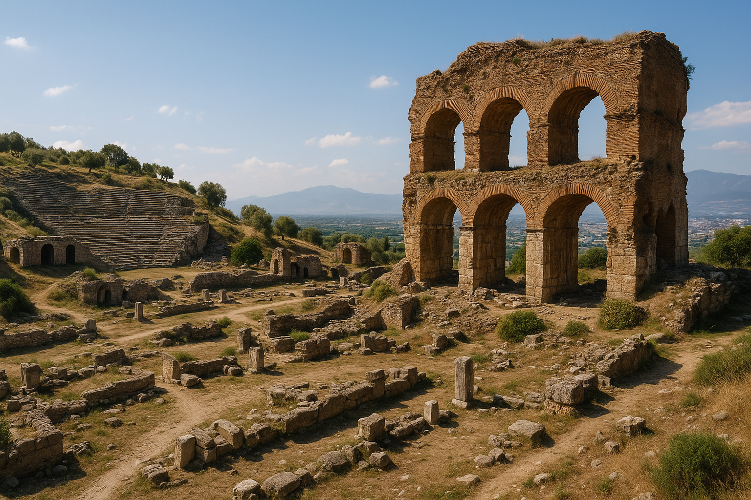
الطبوغرافيا الحضرية والبقايا الهيكلية
احتلّت أورثوسيا موقعًا على قمة تلّة تطلّ على وادي بويوك منديريس (المياندر)، ومدينة نيسا القديمة مرئية على التلال المقابلة إلى الشمال على مسافة نحو 10–12 ميلًا (16–19 كم). كانت المدينة تقع على الضفة اليسرى لنهر المياندر، قريبًا من ألاباندا.
| المنشأة | الحقبة | الحالة الراهنة |
|---|---|---|
| المسرح | هلنستية–رومانية | درجات المقاعد لا تزال سليمة إلى حدٍّ بعيد |
| القلعة البيزنطية | بيزنطية (القرنان 5–7 م) | أسوار دفاعية على القمة |
| المدافن | حقب متعددة | قبور على المنحدرات المحيطة؛ توابيت زخرفية وقبور صخرية |
| أسوار المدينة | هلنستية–رومانية | قائمة جزئيًا |
| الغرف السفلية | رومانية؟ | حجرات سفلية مقببة |
| الحي السكني | رومانية | أرضيات فسيفساء مكتشفة (فسيفساء المصارعين) |
تشير القلعة البيزنطية على القمة إلى أن أورثوسيا احتفظت بأهميتها الاستراتيجية حتى وقت متأخر من العصور القديمة المتأخرة. وجعل موقعها المرتفع فوق وادي المياندر الخصيب منها نقطة تحصين طبيعية، وتمثّل القلعة المرحلة الأخيرة من الاستيطان النشط في الموقع.
التاريخ الكنسي
خدمت أورثوسيا بوصفها مقرًا أسقفيًا (أبرشية) من تاريخ مبكر في العهد المسيحي. وحضر أساقفة المدينة عدة مجامع كنسية، مما يؤكد أهمية أورثوسيا المستمرة في الجغرافيا الإدارية للإمبراطورية البيزنطية.
| الحقبة | الوضع |
|---|---|
| البيزنطية المبكرة (القرنان 4–5) | تأسيس الأبرشية |
| البيزنطية الوسطى | مقر أسقفي نشط |
| ما بعد البيزنطية | لم يعد إقامةً؛ مقر أسقفي شرفي مستمر |
| الحديثة | مقر أسقفي شرفي لأورثوسياس في كاريا (الكنيسة الكاثوليكية الرومانية) |
حقيقة أن أورثوسيا لا تزال مقرًا أسقفيًا شرفيًا للكنيسة الكاثوليكية الرومانية حتى اليوم — يُعيَّن لأساقفة دون أبرشية إقامة — تمثّل بقاءً لافتًا للهوية الكنسية للمدينة، يربط موقعًا على تلة خراب في ريف أيدن بالهيكل الإداري للكنيسة الكاثوليكية الحديثة.
المصادر
- https://en.wikipedia.org/wiki/Orthosia_(Caria
- https://tr.wikipedia.org/wiki/Orthosia_(Karya
- https://commons.wikimedia.org/w/index.php?search=Orthosia+–+Yenipazar,+Aydın&title=Special:MediaSearch&type=image
- https://en.wikipedia.org/wiki/Orthosia_–_Yenipazar,_Aydın
التحليل التاريخي المتعمق
التطبّق السياسي
ينبغي تفسير أورثوسيا – ينيپازار، أيدن من خلال التحولات في السلطة السياسية، لأن كل نظام غيّر الأولويات الإدارية والاستثمار الحضري والعمارة الرمزية. وهذا يعني أن الآثار المرئية ليست حجارة محايدة؛ إنها تعكس قرارات تاريخية تتعلق بالسيطرة والشرعية والاستراتيجية الإقليمية بعيدة المدى.
التكيّف الحضري
تطوّرت المدن وفقًا للطبوغرافيا والموارد وقيود التنقّل. وفي مواقع كأورثوسيا – ينيپازار، أيدن، يمكن تتبّع التكيّف في مسارات الحركة وأنظمة الأسوار وإدارة المياه وإعادة توزيع الفضاءات العامة عبر الزمن.
الاستمرارية المادية وإعادة الاستخدام
من الحقائق الأثرية الجوهرية إعادة الاستخدام: كثيرًا ما انتقلت الكتل والنقوش والعناصر المعمارية عبر الحقب. وإعادة الاستخدام ليست مجرد ممارسة نفعية — إنها أيضًا رسالة ثقافية، إذ تحفظ المجتمعات اللاحقة وتحوّل وتعيد تفسير المكانة السابقة بصورة انتقائية.
الطقوس والذاكرة العامة
كثيرًا ما تتداخل الفضاءات المقدسة والمدنية في المدن العريقة. يمكن للمشاهد الطقسية أن تستمر حتى حين تتغيّر الأنظمة السياسية، مما يجعلها حاسمة لدراسة الاستمرارية في الذاكرة الجمعية.
إطار التفسير التفصيلي للزوار
استخدم هذا الإطار المؤلف من 8 خطوات في الموقع:
- تثبيت التهيئة بالطبوغرافيا وسياق المسار.
- تحديد النظام الهيكلي الأفضل حفظًا (أسوار، ميناء، مسرح، معبد، إلخ).
- التمييز بين المرحلة الأولية والتدخلات اللاحقة.
- المقارنة بين القطاعات الضخمة وقطاعات الحياة اليومية.
- قراءة البنية التحتية للمياه والخدمات اللوجستية بوصفها أنظمة بقاء.
- تقييم المحور الرمزي/الطقسي وسياسة الرؤية.
- تتبّع أدلة إعادة الاستخدام والإصلاح.
- الخاتمة بعلاقة المدينة بالمشهد الطبيعي من منظر علوي نهائي.
تُحسّن هذه الطريقة جودة التفسير لكلٍّ من الزوار العاميين والقراء المتقدمين.
التخطيط العملي للباحثين والمسافرين
- خصّص ما لا يقل عن دورة تفسير كاملة (2–4 ساعات).
- إن أمكن، اقرن زيارة الموقع بسياق المتحف المحلي.
- سجّل الملاحظات حسب المرحلة، لا حسب ترتيب الملاحظة العشوائي.
- افصل ما هو مرئي مباشرةً عمّا هو مستنتج.
- استخدم الخرائط والارتفاع للتحقق من افتراضات الحركة.
أسئلة وأجوبة موسّعة للزوار
هل هذا الموقع مخصص لمتخصصي علم الآثار فحسب؟
لا. التخطيط المنظم للمسار والإطار التاريخي الأساسي يجعلان الموقع مفهومًا لغير المختصين.
لماذا تتداخل حقب مختلفة في مكان واحد؟
لأن المدن أنظمة حية. يُعاد بناؤها وتوظيفها وإعادة تأطيرها سياسيًا لا أنها تُنشأ مرة واحدة.
ما الطريقة الأكثر موثوقية لتجنّب التفسير السطحي؟
اتّبع التسلسل الزمني، وقارن الطبقات، وادرج البنية التحتية والمشهد الطبيعي في قراءتك.
هل ينبغي تجنّب الزيارات الشتوية؟
ليس بالضرورة. يمكن أن يوفّر الشتاء كثافة أقل من الحشود ووتيرة تفسيرية أفضل إذا كانت أحوال الطقس مقبولة.
ما الذي يميّز هذا الموقع عن سائر المدن القديمة؟
مزيجه المحدد من الجغرافيا والتاريخ السياسي والعمارة والاستمرارية عبر انتقالات تاريخية متعددة.