佩尔佩雷涅(Perperene)(在拜占庭时期亦称 狄奥多西乌波利斯(Theodosioupolis))是一座坐落于 科扎克高原(Kozak Plateau) 上的古代 密细亚(Mysia) 城市,位于 佩加蒙(Pergamon)(今贝尔加马)以北约 25 公里处。佩尔佩雷涅在古代以其 铜矿 和上乘的 葡萄园 而闻名,曾作为 佩加蒙王国 统治者的夏季高地避暑地。城市的钱币上印有 葡萄串 与 阿波罗 头像,证明这是一座繁荣的社群,其 佩尔佩雷涅葡萄酒 在公元 2 世纪曾受到著名医生 盖伦(Galen) 的赞誉。该城对山间隘口的战略性控制、在阿塔利德经济圈中的角色,以及后来转变为拜占庭主教区狄奥多西乌波利斯,共同赋予它跨越逾千年安纳托利亚历史的层层意义。
目录
为什么佩尔佩雷涅重要
-
古代的葡萄酒遗产。 佩尔佩雷涅是古代凯科斯河(Caicus,今巴克尔恰伊河)河谷中最重要的葡萄酒生产聚落之一。马可·奥勒留皇帝的御医盖伦特别赞誉佩尔佩雷涅葡萄酒的品质与药用价值,认为它属于整个西安纳托利亚地区最优秀的葡萄酒之列。城市钱币上的葡萄串图案确认了葡萄种植作为核心经济活动至少可上溯至公元前 4 世纪。
-
战略性的高地位置。 佩尔佩雷涅位于海拔约 500–700 米的科扎克高原之上,控制着将密细亚内陆与爱琴海岸连接起来的山间隘口和陆路。这使其成为佩加蒙王室的天然夏季避暑地,可逃离巴克尔恰伊平原的低地酷热以及易患疟疾的沼泽地带。
-
铜矿经济。 古代史料,包括斯特拉博《地理志》第十三卷,记载佩尔佩雷涅附近一带蕴藏铜矿。铜的开采与贸易补充了农业经济,并将该城与更广阔的地中海金属贸易网络相连,使安纳托利亚与爱琴海诸岛及希腊本土相通。
-
狄俄尼索斯崇拜与节庆文化。 佩尔佩雷涅与酒神和节庆之神狄俄尼索斯崇拜的关联,经由钱币学证据和农业地景得到了进一步强化。这种宗教与经济的联结与西安纳托利亚其他葡萄酒生产城市相似,例如尼萨(Nysa)和忒奥斯(Teos)——在那些城市中,狄俄尼索斯崇拜同样十分突出。
-
拜占庭延续。 该城在罗马晚期或拜占庭早期被改名为狄奥多西乌波利斯,表明聚落延续并在基督教时代仍具行政重要性。一座异教神庙很可能被改建为教堂,城市也作为主教座堂所在地运作——这表明即使政治重心发生转移,高地社群仍然保有其重要地位。
-
通往佩加蒙腹地生活的窗口。 尽管佩加蒙本身是研究最为充分的希腊化城市之一,其卫星聚落如佩尔佩雷涅却仍鲜少被探究。研究佩尔佩雷涅为理解阿塔利德王国的乡村与半城市生活提供了难得的机会,包括农业生产、采矿,以及首都城市与其资源供给腹地之间的关系。
地理与环境
佩尔佩雷涅位于 科扎克高原——伊兹密尔省贝尔加马西北的一片高地区域,以松林和花岗岩露头为特色。该高原海拔在 500 至 800 米之间,气温较周围的巴克尔恰伊河(古凯科斯河)河谷低地凉爽。
城市的遗迹位于现代村庄 阿萨厄贝伊(Asagibey)(旧时与科扎克地区有所关联)附近。地形特征包括:
- 松林覆盖的山坡,如今在土耳其红松(Pinus brutia)与意大利伞松(Pinus pinea)的浓密林冠之下,掩藏了大量古代城市肌理
- 花岗岩基岩,在古代为城墙、地基和纪念性建筑提供了建造材料
- 山涧溪流,由季节性降雨与融雪所滋养,支持农业、小规模灌溉以及聚落的用水需要
- 全景视野,向南俯瞰巴克尔恰伊平原,在晴朗的日子里可以远眺佩加蒙作为远方卫城轮廓的剪影
科扎克高原如今以其 松子(çam fıstığı)而闻名,这一高地农业传统可能呼应了古代的土地利用模式。该地区的微气候——生长季节白天温暖、夜晚凉爽——在古代非常适合葡萄种植。对该高原植物多样性的现代研究已辨识出与古代地中海农业体系相符的物种,包括野生葡萄品种。
科扎克高原的地质以 科扎克花岗闪长岩 为主,这是一种深成岩岩体,为古代建造者提供了优良的建筑材料。同样的地质构造中也含有支撑佩尔佩雷涅采矿经济的含铜矿脉。地球化学调查证实,在更广阔的科扎克地区存在黄铜矿和孔雀石矿藏,这与古代关于铜矿开采的记载一致。
从佩加蒙到达此处的路径沿着穿越山间隘口的古道前行,徒步约需半天,骑骡子则需数小时。这种相对接近的距离使佩尔佩雷涅成为一个实用的季节性避暑地,同时仍能享受高海拔所带来的、可缓解夏季酷热的清凉。该路线很可能先穿越云特山(Yuntdağ)山麓,然后上升至高原本身,沿着提供沿途水源的溪谷而行。
周边地景不仅支撑葡萄种植与铜矿开采,也支撑牲畜放牧、木材采伐以及芳香树脂的采集——所有这些资源都将佩尔佩雷涅与佩加蒙王国更广阔的经济体相连。
历史年表
前希腊化时期(公元前 3 世纪以前)
- 科扎克高原显示出至少可上溯至早期青铜时代的居住证据,尽管佩尔佩雷涅本身要到希腊化时期才进入文字记录。
- “佩尔佩雷涅”这一名称很可能源自前希腊语,可能为安纳托利亚语(卢维语或密细亚语)起源,提示在希腊殖民之前就已存在本土聚落。语言学家曾提出与卢维语词根的关联,但尚未确立确凿的词源。
- 高原的天然资源——铜、木材、水以及肥沃的高地土壤——本就足以在有史时代之前就吸引聚落形成。
- 在更广阔的科扎克地区的调查中,曾注意到散落的早期与中期青铜时代地表陶片,但要将其直接归属于佩尔佩雷涅,则需进一步发掘。
希腊化时期(公元前 3–2 世纪)
- 在 佩加蒙王国(阿塔利德王朝,公元前 282–133 年)治下,佩尔佩雷涅作为高地卫星聚落运作,处于王国的行政与经济轨道之内。
- 阿塔利德诸王,尤其是 欧迈尼斯二世(Eumenes II)(在位公元前 197–159 年)和 阿塔洛斯二世(Attalos II)(在位公元前 159–138 年),将佩加蒙的领土控制扩展到周围的高地,包括科扎克高原。佩尔佩雷涅的铜和葡萄酒成为王国精致经济体系的一部分。
- 阿塔利德的行政以高效管理王室土地与资源而著称。佩尔佩雷涅很可能向佩加蒙国库贡献农业剩余和矿产资源,这些收入资助了今日仍可见于佩加蒙卫城的伟大建设计划。
- 已知最早的佩尔佩雷涅钱币可追溯至 公元前 386–330 年 左右,正面饰以阿波罗的桂冠头像,背面则为葡萄串,以青铜铸造(AE Chalkus)。这些钱币主要在本地和区域经济中流通。
- 选择阿波罗作为钱币神祇,可能既反映了城市与农业丰饶(阿波罗作为田园繁荣之神)的关联,也反映了在希腊化希腊框架中的文化精致性。
罗马时期(公元前 133 年 – 公元 4 世纪)
- 最后一位阿塔利德国王 阿塔洛斯三世(Attalos III) 于 公元前 133 年 将其王国遗赠予罗马之后,佩尔佩雷涅成为罗马 亚细亚行省 的一部分。这一过渡似乎相对平稳,城市在罗马治下继续其农业与采矿活动。
- 城市在罗马统治下继续铸造半自治钱币,安东尼·庇护(Antoninus Pius)(公元 138–161 年在位)治下的钱币显示出戴头盔的雅典娜头像,与传统葡萄图案并列。这种双重图像暗示了军事与农业的双重身份。
- 佩加蒙的盖伦(Galen of Pergamon)(公元 129–216 年)——历史上最具影响力的医生之一——在其医学著作中赞誉了佩尔佩雷涅的葡萄酒,认为它们适合用于治疗。在 《论食物的性质》 中,盖伦讨论了佩加蒙地区不同葡萄酒所具有的不同药用属性,其中佩尔佩雷涅葡萄酒因其平衡与适中的强度而尤其受到推崇。
- 这座城市在整个罗马帝国时期作为一个农业与采矿社群保持了适度的繁荣,得益于促进区域贸易的罗马治世(Pax Romana)。
- 罗马时期的基础设施改良可能包括道路升级,使佩尔佩雷涅与佩加蒙低地更加有效地相连,尽管该遗址尚未记录到特定的罗马道路遗迹。
拜占庭时期(公元 4–12 世纪)
- 该城被改名为 狄奥多西乌波利斯,可能是为纪念狄奥多西一世皇帝(在位公元 379–395 年)或狄奥多西二世(在位公元 408–450 年)。这一改名将佩尔佩雷涅纳入了拜占庭省级体系的行政等级之中。
- 一座异教神庙被改建为 拜占庭教堂,反映了该地区的基督教化。在公元 4–6 世纪的安纳托利亚,将异教宗教建筑改作基督教礼拜之用是一种普遍做法。
- 城市作为 主教座堂所在地(主教区)运作,表明其在拜占庭帝国教会等级中持续具有行政重要性。狄奥多西乌波利斯的主教曾在教会会议记录中被提及。
- 这一时期的 防御城墙 留存至今,表明在动荡时期需要防御,尤其是在 7–8 世纪的阿拉伯人入侵以及后来的突厥人入侵期间。
- 随着政治与经济中心向沿海以及向君士坦丁堡转移,高原上的聚落逐渐萎缩。到中世纪晚期,这处高地聚落已显著收缩。
奥斯曼时期及以后
- 在该地区被突厥人征服之后,科扎克高原成为奥斯曼行政领土的一部分。古代遗迹逐渐被纳入乡村地景之中,当地村民将古代建筑石材用于建造。
- 高原的松子经济在奥斯曼时期发展起来,并延续至今,为科扎克地区社群提供了主要的生计。
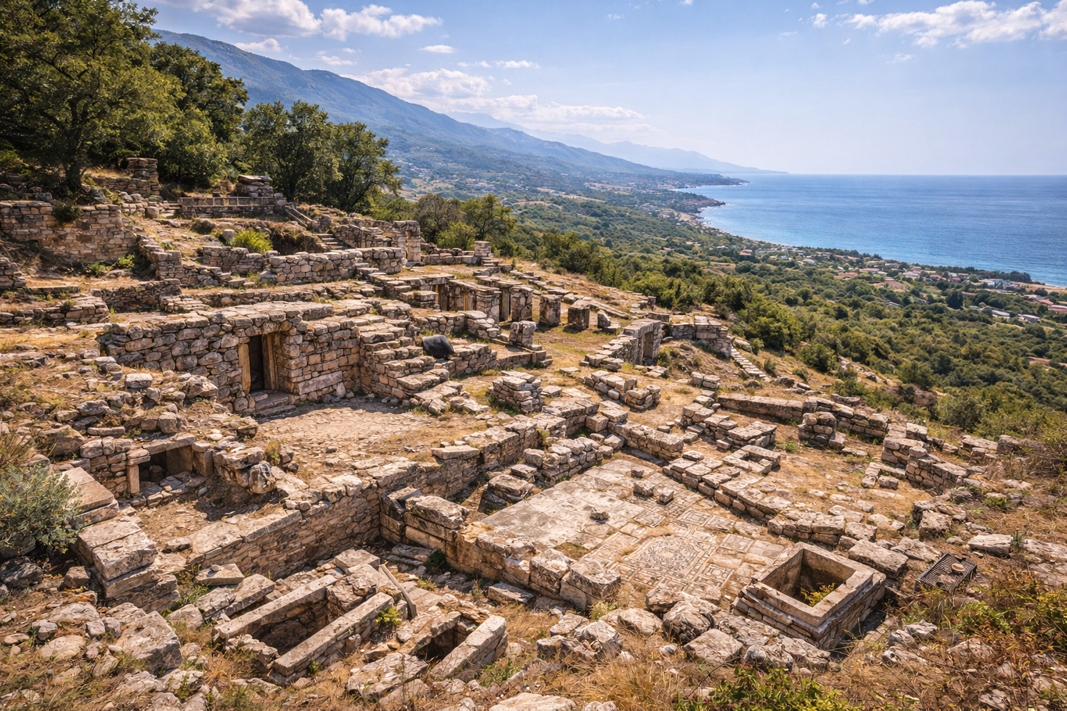
主要纪念物与遗迹
剧场
在一处天然斜坡上,已辨识出一座 小型希腊化剧场 的遗迹,其朝向利用山坡作为座位区(cavea)。该结构在规模上较为适度,与佩加蒙宏大的剧场(可容纳 10,000 人)相比,与佩尔佩雷涅作为次级聚落的角色相一致。可见的特征包括:
- 部分保存的座位排,雕凿于或安置于天然岩石之上
- 底部乐队席(orchestra)区的轮廓
- 来自舞台建筑(skene)的散落建筑石块
- 剧场的朝向显示其大致朝南,为观众提供了越过山坡眺望远方河谷的视野
希腊化时期较小聚落中的剧场兼具娱乐与公民集会两种功能,佩尔佩雷涅的剧场很可能举办过与狄俄尼索斯崇拜相关的宗教节庆,与该城的葡萄种植身份相一致。
神庙 / 拜占庭教堂
考古证据指向一处 神庙基址,可能献祭给阿波罗或狄俄尼索斯,后来被改建为一座拜占庭教堂。这种转变在整个安纳托利亚是一种常见模式,代表了宗教变迁的物质化体现。可见的遗存包括:
- 地基墙体,显示出两个不同的建造阶段(希腊化时期原始结构与拜占庭时期的改造)
- 来自希腊化时期的再利用建筑元素(spolia)被纳入后来的拜占庭石作之中,包括柱鼓和雕刻石块
- 可能属于神庙檐部或教堂装饰的雕刻石碎片
- 在基督教改造期间增建的可能的半圆形后殿结构
神庙的最初奉献对象仍不确定,但该城与阿波罗(钱币图像)以及狄俄尼索斯(葡萄酒文化)的强烈关联,提示这两位神祇之一最有可能是其守护神。
城墙
最显著的留存特征是 防御城墙的环线,主要属于拜占庭时期,但可能纳入了希腊化时期的地基。关键特征包括:
- 使用当地花岗岩块的粗糙顺砌石作,某些段落则显示出更为精细的方石(ashlar)工艺
- 沿高原天然防御等高线延伸的城墙段落,顺着山脊线和悬崖边缘
- 至少有一处可辨识的城门段落,两侧带有加厚的墙体
- 跨越多个世纪的修补与重建证据,在剖面中可看到不同的灰浆类型和切石技术
- 估计原始环线长度为数百米,围合了主要聚落区
集市区
聚落中心的一片相对平坦的区域已被初步辨识为 阿戈拉(agora)(公共市场与公民中心)。地表发现包括:
- 从希腊化时期到拜占庭时期的陶片,表明持续使用
- 建筑碎片,包括柱鼓、柱础以及科林斯式柱头碎片
- 总体布局表明这是一处适度但功能完备的公民空间,最长方向可能为 40–60 米
- 阿戈拉本应作为商业、公民生活以及宗教游行的主要聚集场所
蓄水池与水利管理
已记录到若干 岩凿蓄水池,反映出高地聚落在干燥的夏季月份需要管理水资源。这些水利设施展示了适应高原季节性水资源可得性的实用工程:
- 直接凿入花岗岩基岩、内壁抹灰以防止渗漏的蓄水池
- 一些蓄水池与渠道系统相连,可将雨水径流引入蓄水
- 水利管理基础设施对于在地表水于夏季有限的高原上支撑常驻人口至关重要
墓地
在聚落附近已注意到墓葬区域,但尚未对墓地进行系统性的调查。地表证据显示:
- 周围山坡上的岩凿墓葬
- 散落的石棺碎片
- 墓地区域很可能沿着进城的道路延伸,与古代标准做法相一致
考古工作
佩尔佩雷涅未曾成为大规模系统性发掘的对象。对该遗址的认识主要来源于:
-
19 世纪的勘测,由欧洲旅行家和地理学家进行,他们在探索佩加蒙腹地时记录了可见的遗迹并抄录了铭文。这些早期访客提供了对该遗址最早的现代描述,记录了城墙、柱身碎片和带有铭文的石头。
-
钱币学研究,对城市的钱币类型进行了编目,为年代判定、经济活动和宗教归属提供了证据。WildWinds 数据库记录了佩尔佩雷涅自公元前 4 世纪至公元 2 世纪的多种钱币类型。这些钱币是该遗址历史的主要年代锚点。
-
学术研究,关于科扎克高原的研究,包括 M. 托赞(M. Tozan)于 2023 年发表于 Olba(第 31 卷,第 381–400 页)的研究,题为 “古代的科扎克高原:地名、路线与自然资源”,该文分析了佩尔佩雷涅在更广阔的高地聚落网络中所扮演的角色。这项研究将佩尔佩雷涅置于一个利用高地矿产与农业资源的高原聚落体系之中。
-
地表调查,由土耳其考古团队开展,绘制了可见遗迹的范围,但未进行深度发掘。这些调查确立了聚落的大致边界并辨识了主要纪念物的位置。
-
地质与地球化学调查,针对科扎克高原的研究证实了存在含铜矿藏,与古代关于采矿活动的记载相符。
该遗址在很大程度上尚未发掘,这意味着地表之下存在重大的考古潜力。如今覆盖整个高原的森林既保护了遗迹免受农业扰动,也使其更难进行全面调查。未来的系统性发掘可能揭示有关希腊化时期省级建筑、罗马时期经济活动,以及拜占庭高地基督教化进程的细节。
发掘的匮乏也意味着佩尔佩雷涅是佩加蒙地区保存最完好且尚未发掘的希腊化卫星遗址之一,使其成为未来研究的候选目标,这些研究可能显著推进对阿塔利德王国乡村经济的理解。
参观信息
如何到达
佩尔佩雷涅位于科扎克高原地区,可从贝尔加马沿西北方向驱车前往。从贝尔加马市中心出发,沿科扎克路驾车约需 30–40 分钟。遗迹位于 阿萨厄贝伊村(亦写作 Asagibey Köyü)附近。当地道路在最后一段可能为非铺装路面,需要离地间隙适中的车辆。
从伊兹密尔出发,贝尔加马位于约 110 公里的北方(驾车约 1.5 小时)。从伊兹密尔–恰纳卡莱高速公路上,从贝尔加马匝道驶出,按指示前往市中心,然后向西北方向前往科扎克高原。
最佳参观时间
- 春季(4–6 月): 野花在整个高原盛开;气温温和宜人,适合徒步。松林散发着最浓郁的芬芳,地景因冬雨而呈现绿意。
- 秋季(9–11 月): 天气宜人,光线金黄,松子收获季节也增添了氛围。当地村庄因收获而热闹,游客可购买新鲜松子。
- 夏季: 高原比贝尔加马周围的低地明显凉爽(通常低 5–10 度),使其成为躲避沿海酷热的避难所——正如古代一样。即便如此,正午的阳光依然强烈。
- 冬季: 较高海拔可能有雪;进入道路可能具有挑战性。该遗址通常可达性较差,但能提供独处的体验和壮丽的冬日地景。
实地体验
- 该遗址 未被正式组织 为旅游景点。没有售票亭、标识或专用停车区。
- 遗迹散布于一片林地之中,需要一定的探索才能找到。一种冒险精神以及愿意走过林间小径的态度是不可或缺的。
- 这种体验最适合喜欢 避开主流路线 的考古遗址与自然漫步的访客。这不是一处精修的博物馆遗址,而是与自然的、覆盖植被的历史的相遇。
- 包括穿越森林的步行时间在内,完整参观请预留 1.5 至 3 小时。
- 如有可能,请带上一位当地联系人或 GPS 坐标,因为从主干道上对遗迹的指示牌并不明显。
实用提示
- 请穿着抓地力良好的结实徒步鞋;地形不平,常覆盖松针,可能很滑。
- 请携带饮用水和防晒用品,因为遗址内没有任何设施。
- 建议携带 GPS 设备或下载好的离线地图,因为标识极少。
- 在春季和夏季的林地区域,请留意蜱虫。
- 可结合 佩加蒙(贝尔加马) 的参观,作为一次完整的全日历史游览,将佩尔佩雷涅置于更广阔的阿塔利德王国之中加以理解。
- 科扎克高原的村庄提供当地的 松子产品、蜂蜜以及供应传统爱琴海菜肴的简朴乡村餐馆(köyleri)。
- 摄影在清晨与午后的光线下效果绝佳,此时花岗岩遗迹在深色松林的背景下熠熠生辉。
周边景点
- 佩加蒙卫城与阿斯克勒庇翁神殿(联合国教科文组织世界遗产),南距 25 公里——这座宏伟的希腊化都城曾是佩尔佩雷涅的宗主城邦
- 科扎克高原松林,适合徒步、山地骑行和自然漫步
- 贝尔加马考古博物馆,可了解地区考古发现的背景,包括来自佩加蒙发掘的文物
- 阿利亚诺伊(Allianoi) 古代温泉浴场(部分被约尔坦勒水坝淹没)
- 科扎克村庄手工艺品——高原村庄以松子加工和传统石砌建筑而闻名
常见问题
佩尔佩雷涅在古代以什么闻名?
佩尔佩雷涅最为人所知的是其 葡萄酒生产 与 铜矿。城市钱币上一贯印有葡萄串,医生盖伦也特别赞誉佩尔佩雷涅葡萄酒的品质与药用价值。科扎克高原的海拔与微气候为葡萄种植创造了理想条件,白天温暖、夜晚凉爽,有助于葡萄风味的发展。
为什么该城被改名为狄奥多西乌波利斯?
在拜占庭时期,安纳托利亚的许多城市都被改名以纪念皇帝或基督教人物。佩尔佩雷涅被改名为 狄奥多西乌波利斯,可能是为纪念狄奥多西一世皇帝(在位公元 379–395 年)或狄奥多西二世(在位公元 408–450 年),反映了该城在早期基督教行政网络中持续的重要性,以及通过城市命名来纪念统治者这一更广泛的帝国惯例。
佩尔佩雷涅与佩加蒙有关吗?
是的,佩尔佩雷涅曾作为佩加蒙王国的高地卫星城运作。阿塔利德王朝控制着周边地区,该城既作为经济资源中心(铜、葡萄酒、木材)又作为躲避低地酷热的季节性避暑地而发挥作用。佩加蒙与佩尔佩雷涅之间的关系,典型地体现了希腊化王国如何将其领土组织为一个相互依存的聚落网络。
我可以在没有导游的情况下参观佩尔佩雷涅吗?
可以,但该遗址尚未发掘,也没有标识。如果你大致知道阿萨厄贝伊村附近遗迹的位置,并携带 GPS 坐标或详细地图,自助参观是可行的。如希望获得更详尽的体验,可考虑聘请熟悉科扎克高原的贝尔加马当地导游,或联系贝尔加马博物馆寻求建议。
佩尔佩雷涅与佩加蒙相比如何?
佩尔佩雷涅在规模上远小于佩加蒙,纪念性也远不及之。佩加蒙是希腊化世界最伟大的城市之一,拥有可与亚历山大里亚相媲美的图书馆,而佩尔佩雷涅则是一座适度的高地小镇。其吸引力在于其 未被发现的氛围、森林环境,以及没有人潮——这与游人云集的佩加蒙卫城形成鲜明对比。参观过佩加蒙的访客,如果也能参观其卫星聚落之一,便能对阿塔利德世界获得更为丰富的理解。
佩尔佩雷涅铸造过哪些钱币?
已知最早的钱币(约公元前 386–330 年)是青铜小铜币(chalkos),正面饰有 阿波罗 的桂冠头像,背面则为 葡萄串。罗马治下后期的半自治钱币(公元 2 世纪)则显示戴头盔的 雅典娜 与葡萄图案并列,既反映了农业身份的延续,也反映了在罗马文化影响下不断演化的公民象征。
古代葡萄酒生产与科扎克高原现代农业之间是否有任何联系?
尽管商业葡萄种植已不再是科扎克高原的主要活动,但该地区的农业传统通过松子采收、橄榄种植和小规模耕作得以延续。曾一度有利于葡萄酒种植的微气候,如今支撑着出产土耳其高端松子的伞松林。一些当地家庭仍维持着小型葡萄棚架,这是一种或可追溯至古代的传统的余韵。
在佩尔佩雷涅是否发现过任何铭文?
19 世纪的旅行者和后续的调查中记录了少量铭文,主要为希腊文。这些铭文提供了城市公民组织、宗教奉献以及当地官员姓名的证据。然而,与该地区发掘更为充分的遗址相比,铭文记录是有限的。
建筑测量与关键数据
| 特征 | 测量 / 细节 |
|---|---|
| 遗址海拔 | 海拔 500–700 米(科扎克高原) |
| 距佩加蒙距离 | 约 25 公里以北 |
| 剧场类型 | 小型希腊化,山坡式座位区 |
| 阿戈拉(估计) | 最长方向 40–60 米 |
| 防御城墙(估计环线) | 数百米 |
| 蓄水池构造 | 凿入花岗闪长岩基岩,内壁抹灰 |
| 基岩地质 | 科扎克花岗闪长岩(深成岩) |
| 已确认的含铜矿物 | 黄铜矿(CuFeS2)、孔雀石(Cu2CO3(OH)2) |
钱币学证据
佩尔佩雷涅的钱币为该城历史提供了最精确的年代框架。佩尔佩雷涅钱币的权威目录由巴尔特(Barth)和施陶贝尔(Stauber)于 1994 年发表于 Epigraphica Anatolica 第 23 卷(第 59–82 页),题为 “Die Münzen von Perperene”。
| 时期 | 面值 | 正面 | 背面 | 参考文献 |
|---|---|---|---|---|
| 约公元前 386–330 年 | AE 小铜币(青铜,约 13 毫米) | 阿波罗桂冠头像,右向 | 葡萄串带茎,PERPERHNIΩN | BMC 2; SNG France 2309; Barth-Stauber 62.10e |
| 约公元前 386–330 年 | AE 小铜币(变体) | 阿波罗桂冠头像,右向 | 葡萄串,PER 或 PERPE | SNG France 2308 |
| 公元 138–161 年(安东尼·庇护) | AE 半自治钱币(约 13 毫米) | 雅典娜戴头盔头像,右向,胸前佩戴埃癸斯 | 葡萄串图案 | 帝国行省钱币 |
后期钱币从阿波罗向雅典娜的转变,反映了佩尔佩雷涅在罗马治下不断演化的公民身份。所有时期都一贯保留的葡萄图案则强调,葡萄种植在至少五个世纪间始终是该城决定性的经济活动。
佩尔佩雷涅的钱币主要在凯科斯河(巴克尔恰伊河)河谷的本地与区域经济中流通。未发现银币面值,这与该城作为佩加蒙经济圈内的次级聚落而非具有重大商业意义的独立铸币地的地位相一致。
盖伦关于佩尔佩雷涅葡萄酒的见证
佩加蒙的盖伦(公元 129– 约 216 年),纪念碑式著作 《论食物的性质》(De Alimentorum Facultatibus) 的作者,为佩尔佩雷涅提供了最重要的古代文献见证。在这部药理学论著中,盖伦系统地评估了佩加蒙地区葡萄酒的治疗特性,按原产地、强度以及对不同医疗状况的适用性进行了分类。
盖伦将佩尔佩雷涅葡萄酒列为优秀的地方佳酿之一,指出其适中的强度和均衡的特质——这些品质使其适合用于康复期病人,也适合那些遵循其饮食建议的人作日常饮用。他的推崇不仅具有文献意义;作为马可·奥勒留皇帝(公元 161–180 年在位)的御医,盖伦的见解在整个罗马医学界都具有巨大的权威。
盖伦葡萄酒评估的更广阔背景揭示了横跨西安纳托利亚的一处精致的古代葡萄酒地景。他将佩加蒙腹地的葡萄酒与爱琴海及东地中海其他地区的葡萄酒进行了比较,将凯科斯河谷的葡萄酒置于可与莱斯沃斯、希俄斯以及意大利半岛的佳酿相竞争的地位。
阿塔利德腹地经济
佩尔佩雷涅与佩加蒙的关系,典型地体现了阿塔利德王国的经济组织方式——该王国在古代以高效管理王室庄园和资源开采而著称。佩加蒙王国(公元前 282–133 年)通过一种集中化的体系管理其领土,将不同的经济职能分配给不同的聚落:
- 佩加蒙(首都): 行政、文化与宗教中心;农业剩余与原材料的主要消费者
- 佩尔佩雷涅(高地卫星城): 葡萄酒、铜矿石、木材以及牲畜产品的供应地;精英阶层的季节性避暑地
- 沿海聚落: 海上贸易与渔业
阿塔利德国库——资助了伟大的图书馆、宙斯祭坛以及佩加蒙卫城的纪念性台地建筑——依赖来自像佩尔佩雷涅这样的卫星聚落的收入流。从科扎克高原的黄铜矿矿藏中开采出的铜,可能在当地或佩加蒙加工,并进入连接安纳托利亚与爱琴海诸岛、希腊本土及更远地区的地中海贸易网络。
对科扎克地区进行的现代地质调查已证实存在多处与古代描述相符的铜矿化带。主导该高原的花岗闪长岩基岩,含有通常与岩浆-热液晚期作用相关的含铜矿脉。这些矿藏按现代工业标准虽属适度,但对于使用露天采矿和浅竖井技术的古代开采而言,具有重要意义。
铭文记录与公民组织
19 世纪欧洲旅行家和后续考古调查在佩尔佩雷涅记录了少量希腊文铭文。尽管与该地区发掘较为充分的主要城市相比,铭文语料较为适度,但这些铭文为以下方面提供了重要证据:
- 公民官职: 铭刻于石上的命名官员表明,佩尔佩雷涅维持着与希腊化和罗马城市治理相一致的正式公民机构,包括选举产生的执政官和市议会(boule)
- 宗教奉献: 还愿铭文证实了该遗址上的崇拜活动,尽管所敬奉的具体神祇并不总能从残缺的文本中加以辨识
- 丧葬铭文格式: 来自墓地区域的墓碑铭文遵循了横跨西安纳托利亚的地区性常见模式,为命名习俗和家族结构提供了证据
铭文证据,加上钱币学记录(钱币)以及盖伦和斯特拉博的文献见证,为佩尔佩雷涅的公民生活、经济活动以及自公元前 4 世纪至罗马帝国时期在西安纳托利亚更广阔的希腊语世界中的文化整合,提供了三条独立的证据线索。
参考资料与延伸阅读
- Tozan, M. “The Kozak Plateau in Antiquity: Toponyms, Routes and Natural Resources.” Olba 31 (2023): 381-400. Academia.edu
- WildWinds Ancient Coins Database -- Mysia, Perperene. WildWinds
- Strabo, Geography, Book XIII -- 关于密细亚聚落、铜矿以及凯科斯河谷经济地理的参考资料。
- Galen, On the Properties of Foodstuffs -- 关于佩加蒙地区葡萄酒及其药用属性的参考资料。
- Wikipedia -- Perperene
- Pergamon and its Multi-Layered Cultural Landscape -- UNESCO
- Bergama District -- Visit Izmir
- Hansen, E. The Attalids of Pergamon. Cornell University Press, 1971.
- Allen, R.E. The Attalid Kingdom: A Constitutional History. Oxford, 1983.
- Radt, W. Pergamon: Geschichte und Bauten einer antiken Metropole. Darmstadt, 1999.