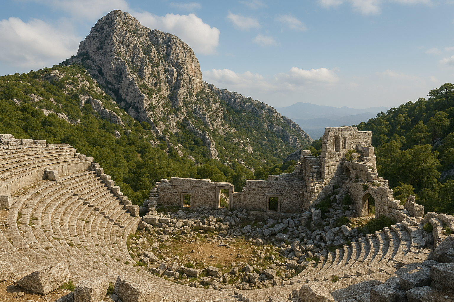
Кремна (также пишется Кремна) — один из наиболее драматично расположенных древних городов Малой Азии, примостившийся на отвесном плато в западных Таврских горах на высоте примерно 1100 м. Основанная как местная писидийская твердыня, она была позднее преобразована в римскую колонию ветеранов при императоре Августе и стала свидетельницей одной из наиболее хорошо задокументированных римских осад в истории во время восстания 278 г. н. э.. Сегодня руины возвышаются над долиной реки Аксу (Кестрос) близ Буджака в провинции Бурдур, предлагая посетителям редкое сочетание военной истории, колониальной архитектуры и потрясающего горного пейзажа.
Содержание
- Почему Кремна важна
- География и положение
- Историческая хронология
- Главные монументы
- Великая осада 278 г. н. э.
- Археологические работы
- Информация для посетителей
- Часто задаваемые вопросы
- Источники и дополнительное чтение
Почему Кремна важна
Кремна заслуживает внимания по нескольким убедительным причинам:
-
Одна из пяти римских колоний в Писидии. Август лично выбрал Кремну как место для поселения легионеров-ветеранов, сделав её Colonia Iulia Augusta Felix Cremnensium. Понимание того, как Рим навязал порядок яростно независимому горному населению, является центральным для изучения римского империализма в Малой Азии.
-
Образцовая римская осада, сохранённая в ландшафте. Осадная рампа, контрвалационные стены, катапультные платформы и снаряды баллист от осады 278 г. н. э. до сих пор видны in situ — наиболее полная сохранившаяся римская осадная система за пределами Восточного Средиземноморья (соперничающая даже с Масадой и Иотапатой).
-
Впечатляющая монументальная архитектура. Адриановская строительная программа оставила после себя форум, базилику, колоннадную улицу, банный комплекс и не менее двух театров — все они цепляются за узкое плато с драматическими инженерными решениями.
-
Окно в писидийскую горную культуру. До римского периода Кремна была домом для местной писидийской общины, чей язык, монеты и религиозные практики заметно отличались от эллинизированных равнин.
-
Панорамная природная обстановка. Виды на 360 градусов на сосновые леса, долину Кестроса и заснеженные вершины Тавра делают Кремну одним из наиболее визуально вознаграждающих археологических памятников юго-западной Турции.
География и положение
Кремна расположена на вытянутом известняковом плато длиной примерно 1200 м и шириной 400 м, круто поднимающемся над окружающим рельефом. Плато естественно защищено с трёх сторон отвесными скалами, обрывающимися на 200–300 метров к долине. Доступ в древности был ограничен узкой седловиной на северо-востоке, где были сосредоточены главные ворота и осадные операции 278 г. н. э.
Город лежит примерно в 30 км к северо-западу от Буджака и примерно в 100 км к северу от Антальи. Река Аксу (древний Кестрос) течёт по долине внизу, связывая этот горный регион с прибрежной равниной Памфилии. Рельеф типичен для горной Писидии: скалистые известняковые гребни, покрытые средиземноморской сосной и зарослями маквиса, с холодными зимами и тёплым сухим летом.
| Характеристика | Подробность |
|---|---|
| Высота | ~1100 м |
| Размеры плато | ~1200 м x 400 м |
| Ближайший город | Буджак (30 км) |
| Провинция | Бурдур |
| Древний регион | Писидия |
| Река внизу | Аксу (Кестрос) |
Окружающий ландшафт включает деревню Джамбазлы, от которой грунтовая дорога ведёт к памятнику. Этот район сегодня малонаселён, что подчёркивает удалённый, крепостной характер Кремны.
Историческая хронология
Доримский период (до 25 г. до н. э.)
Кремна изначально была писидийским поселением. Писидийцы были одним из наиболее воинственных народов южной Анатолии, известным своим яростным сопротивлением внешнему господству. Кремна появляется в античных источниках как естественно укреплённое убежище, которое оказывалось чрезвычайно трудным для захвата. Эллинистические царства — Селевкиды и Атталиды — оказывали ограниченный контроль над писидийскими нагорьями, и Кремна, вероятно, сохраняла значительную автономию.
Августовская колония (с 25 г. до н. э.)
После римской аннексии Галатии в 25 г. до н. э. император Август учредил цепь колоний ветеранов в Писидии для умиротворения региона. Кремна стала Colonia Iulia Augusta Felix Cremnensium, одной из пяти таких колоний (наряду с Антиохией, Комамой, Олбасой и Листрой). Здесь были поселены отставные легионеры, и римская городская сетка была наложена на существующий писидийский город. Латынь стала официальным языком, и Кремна начала чеканить колониальные монеты.
Адриановско-Северовское процветание (II — начало III в. н. э.)
Со времени правления Адриана (правил 117–138 гг. н. э.) до династии Северов (193–235 гг. н. э.) Кремна пережила крупный строительный бум. Комплекс форума и базилики, колоннадная улица (примерно 230 м длиной), банные здания и монументальные ворота были построены или существенно расширены в этот период. Надписи этой эпохи свидетельствуют о состоятельных местных благодетелях, соревновавшихся в украшении своего города.
Восстание и осада (278 г. н. э.)
В бурном позднем третьем столетии главарь разбойников по имени Палфуэрий (или Лидий, как называют его некоторые источники) захватил Кремну и использовал её неприступное положение, чтобы бросить вызов римской власти. Император Проб направил военную силу, которая провела полномасштабную осаду города, построив осадную рампу, кольцевые стены и катапультные платформы. После продолжительной блокады город пал в 278 г. н. э.. Осада продемонстрировала классические римские осадные техники, соперничающие с теми, что были задокументированы Иосифом Флавием во время Иудейского восстания 66–73 гг. н. э.
Поздняя античность и оставление (IV–VII вв.)
После осады Кремна была частично восстановлена и служила епископальной кафедрой (епископством) в поздней античности. В районе форума была построена небольшая церковь. Однако город неуклонно приходил в упадок и был оставлен к VI или VII веку.
Главные монументы
Форум и базилика
В центре плато лежит гражданский форум, мощёная прямоугольная площадь, фланкированная по длинной стороне большой базиликой (судебный и торговый зал). Базилика входит в число крупнейших известных в Писидии, имея центральный неф и боковые нефы. Базы колонн и фрагменты коринфских капителей разбросаны по всей территории.
Колоннадная улица
Простираясь примерно на 230 метров вдоль хребта плато, колоннадная улица была главной церемониальной авеню колонии. Её колонны коринфского ордера некогда поддерживали крытый портик с обеих сторон, давая тень для лавок и общественных собраний. Несколько барабанов колонн и баз остаются стоящими.
Банный комплекс
Расположенные у южного края плато, римские бани входят в число наиболее сохранившихся сооружений Кремны. Можно идентифицировать помещения для фригидария (холодного зала), тепидария (тёплого зала) и кальдария (горячего зала), а также систему гипокауста (подпольного отопления).
Театры
Кремна имела не менее двух театральных сооружений: больший театр, встроенный в естественный склон края плато (вместимость оценивается в 3000–4000 зрителей), и меньший одеон, или булевтерий, для заседаний совета. Больший театр открывает захватывающие виды на долину.
Городские стены и ворота
Естественные скалы плато служили большей частью защиты города. Там, где рельеф допускал подход — в первую очередь на северо-восточной седловине, — были построены существенные стены из тёсаного камня с башнями. Главные ворота города располагались здесь, и большая часть осадной деятельности 278 г. н. э. была направлена на эту уязвимую точку.
Нимфей
Монументальный фонтанный дом (нимфей) был возведён в центре города, питаемый акведуком, приносящим воду из источников окружающих гор. Архитектурные фрагменты с резными молдингами и нишами для статуй сохранились.
Позднеантичная церковь
Однонефная базиликальная церковь была построена в пределах или близ территории форума в V или VI веке, отражая преобразование Кремны из языческой колонии в христианское епископство.
Великая осада 278 г. н. э.
Осада Кремны — один из наиболее замечательных эпизодов римской военной истории в Малой Азии. Вот подробное описание:
-
Предыстория. В хаотические годы позднего третьего столетия (так называемый «Кризис III века») региональный военачальник — по-разному идентифицируемый как Палфуэрий или Лидий — захватил контроль над Кремной и использовал неприступное положение города, чтобы терроризировать окружающую сельскую местность.
-
Имперский ответ. Император Проб (правил 276–282 гг. н. э.) приказал военной экспедиции отбить город. Римские силы разбили лагерь на подступах к плато.
-
Осадная инженерия. Римляне построили массивную осадную рампу (аггер) на северо-восточной седловине, чтобы получить доступ к городской стене. Они также построили кольцевую стену вокруг плато, чтобы предотвратить побег или подкрепление. Катапультные платформы были устроены для обстрела защитников.
-
Свидетельства на местности. Сотни каменных снарядов баллист до сих пор лежат на поверхности вокруг района осадной рампы. Сама земляная рампа, фундаменты циркумвалляции и срезы платформ в скальной породе чётко видны.
-
Падение города. После продолжительной блокады город пал. Согласно некоторым сведениям, лидер мятежников был убит собственными последователями.
-
Научное значение. Стивен Митчелл сравнил осаду Кремны с более известными осадами Масады (73 г. н. э.) и Иотапаты (67 г. н. э.), назвав её одним из наиболее сохранившихся примеров римской осадной войны в древнем мире.
Археологические работы
-
1985–1987: Стивен Митчелл (Эксетерский университет, позже Эдинбургский университет) провёл интенсивное археологическое обследование Кремны при поддержке Британского института археологии в Анкаре (BIAA). Его команда нанесла на карту всё плато, задокументировала осадные сооружения и зарегистрировала более 100 надписей.
-
Публикация 1995 г.: Митчелл опубликовал всеобъемлющую монографию Cremna in Pisidia: An Ancient City in Peace and in War (Duckworth & Classical Press of Wales), определяющий справочный труд по памятнику.
-
2000-е годы и далее: Турецкие археологические команды проводили периодические раскопочные кампании в Кремне, сосредотачиваясь на районе форума, банях и церкви. Новые архитектурные находки и надписи продолжают документироваться.
-
Раскопки 2023 г.: Недавняя раскопочная работа была сосредоточена на вскрытии дополнительных участков колоннадной улицы и уточнении строительных фаз комплекса базилики.
Ключевые участники научных исследований Кремны включают Сару Кормак, Робина Фёрсдона, Эдди Оуэнса и Жана Озтюрка, которые сотрудничали в публикации 1995 года.
Информация для посетителей
Как добраться
- Из Буджака: Двигайтесь на северо-запад по дороге в сторону деревни Джамбазлы (примерно 30 км). Указатель на грунтовую дорогу ведёт к памятнику от деревни. Рекомендуется автомобиль с разумным клиренсом.
- Из Антальи: Возьмите шоссе D-685 на север в сторону Бурдура, затем сверните на запад в Буджаке. Общее время в пути составляет примерно 2 часа.
- Из Бурдура: Направляйтесь на юг через Буджак (всего 45 км).
На месте
- Вход: Памятник имеет открытый доступ без официальной билетной кассы на момент недавних посещений. Уточните на месте о любых изменениях.
- Рельеф: Плато относительно плоское наверху, но подход включает крутые, неровные тропы. Прочная походная обувь необходима.
- Тень и вода: На открытом плато мало тени. Возьмите защиту от солнца и не менее 1,5 литров воды на человека.
- Продолжительность: Отведите от 2 до 4 часов для тщательного посещения, охватывающего форум, колоннадную улицу, бани, театр и район осадной рампы.
Лучшее время для посещения
- Весна (апрель — май) и осень (сентябрь — октябрь) предлагают наиболее комфортные температуры.
- Лето может быть очень жарким на открытом плато; рекомендуются ранние утренние визиты.
- Зима приносит холод и эпизодический снег на этой высоте.
Совмещённые посещения
- Сагалассос (70 км к северо-востоку): Ещё один крупный писидийский город с впечатляющими римскими остатками.
- Бурдурский археологический музей: Содержит артефакты из Кремны и других региональных памятников, включая знаменитый рельеф гладиатора.
- Озеро Бурдур: Живописное солёное озеро для расслабляющей остановки на обратном пути.
Советы
- Носите распечатанный или загруженный план памятника (из публикации Митчелла) для ориентирования.
- Бинокль полезен для обнаружения снарядов баллист и деталей стен через рельеф.
- На памятнике нет ресторанов или магазинов; берите провизию.
Часто задаваемые вопросы
Что отличает Кремну от других древних городов в Турции?
Сочетание в Кремне неприступной природной обстановки, хорошо задокументированной римской колониальной архитектуры и одной из наиболее полных римских осадных систем, сохранившихся в ландшафте, фактически уникально. В отличие от прибрежных городов, таких как Эфес или Перге, Кремна предлагает сырое, нереставрированное переживание горной крепости.
Могу ли я увидеть осадную рампу и снаряды баллист?
Да. Осадная рампа чётко видна как приподнятый земляной склон на северо-восточном подходе к плато. Каменные снаряды баллист (примерно размером с грейпфрут) до сих пор можно найти разбросанными на поверхности в этом районе.
Подходит ли Кремна для семей с детьми?
Памятник включает некоторое лазание по неровному рельефу и открытым обрывам без ограждений. Старшим детям и подросткам это покажется захватывающим, но это не идеально для очень маленьких детей.
Как Кремна сравнивается с Сагалассосом?
Оба — писидийские горные города. Сагалассос больше, более широко раскопан и имеет реконструированный фонтанный комплекс. Кремна более дика, менее посещаема и предлагает уникальное измерение осадной войны. Посещение обоих даёт всеобъемлющую картину римской Писидии.
Ведутся ли продолжающиеся раскопки?
Да. Турецкие университетские команды проводили раскопочные кампании в последние годы, особенно в районах форума и бань. Памятник периодически активен во время летних сезонов раскопок.
Какова была численность населения Кремны?
Оценки различаются, но во время пика во II–III вв. н. э. Кремна, вероятно, насчитывала между 5000 и 10 000 жителей, включая потомков римских ветеранов и местных писидийцев.
Подробные архитектурные размеры
Следующая таблица собирает измерения из обследования Митчелла 1985–1987 годов и последующих турецких раскопочных кампаний, предоставляя количественную картину застроенной среды Кремны.
| Сооружение | Размер | Измерение |
|---|---|---|
| Плато (в целом) | Длина x ширина | ~1200 м x 400 м |
| Колоннадная улица | Общая длина | ~230 м |
| Колоннадная улица | Ордер колонн | Коринфский композитный |
| Форум | Приблизительная площадь | ~60 м x 40 м |
| Базилика | Неф + боковые нефы | Среди крупнейших в Писидии |
| Театр (большой) | Предполагаемая вместимость | 3000–4000 зрителей |
| Одеон | Предполагаемая вместимость | ~500 зрителей |
| Банный комплекс | Последовательность помещений | Фригидарий, тепидарий, кальдарий с гипокаустом |
| Городские стены (СВ седловина) | Конструкция | Тёсаная кладка с выступающими башнями |
| Осадная рампа (278 г. н. э.) | Расположение | Подход с северо-восточной седловины |
| Циркумвалляция (внешняя линия) | Расстояние от внутренней линии | 180–200 м |
Обследование Митчелла зарегистрировало более 100 латинских и греческих надписей по всему плато, многие из которых — посвятительные тексты от адриановской и северовской строительной программы. Шесть вертикальных несущих архитектурных элементов были каталогизированы вдоль колоннадной улицы, включающие одну композитную капитель, три коринфские капители и две анта-балки.
Нумизматический каталог Кремны
Колониальный монетный двор Кремны функционировал с августовского основания до середины III в. н. э., производя бронзовые выпуски с исключительно латинскими легендами — характеристика, отличающая Кремну от чеканок с греческими легендами большинства соседних городов.
| Правление / Период | Аверс | Реверс | Легенда | Ссылка |
|---|---|---|---|---|
| Август (27 г. до н. э. — 14 г. н. э.) | Портрет Августа | Сцена пахоты (sulcus primigenius) | COL CREMNA | RPC I |
| Адриан (117–138) | Бюст Адриана в венке | Аббревиатура COL CRE, орёл или штандарты | COL CRE | Numista 510403 |
| Гордиан III (238–244) | Лучистый бюст | Различные божества (Зевс, Арес, Тюхе) | COL IVL AVG CREMN | SNG France 1796–1803 |
| Транквиллина (241–244) | Драпированный бюст Транквиллины | Стоящая фигура | COL IVL AVG FELICIS CREMNENSIVM | Numista 434814 |
| Филипп I (244–249) | Бюст в венке | Фасад храма, сцены охоты | COL CREMNA | SNG France |
Полное колониальное название — Colonia Iulia Augusta Felix Cremnensium — появляется на более поздних выпусках (Гордиана III и Транквиллины), расширяя сокращённые формы, использовавшиеся в более ранних правлениях. После середины III века производство монет полностью прекратилось, почти наверняка вследствие опустошения, причинённого осадой 278 г. н. э. Никакой послеосадной чеканки не идентифицировано.
Хронология раскопок и научный вклад
Следующая таблица отслеживает основные фазы археологического исследования в Кремне.
| Годы | Исследователь(и) | Учреждение | Деятельность |
|---|---|---|---|
| XIX век | Европейские путешественники (Дэвис и др.) | Различные | Первая локализация и описание |
| 1985–1987 | Стивен Митчелл, С. Кормак, Р. Фёрсдон, Э. Оуэнс, Ж. Озтюрк | Эксетерский университет / BIAA | Интенсивное обследование: нанесено на карту плато, задокументированы осадные сооружения, зарегистрировано более 100 надписей |
| 1989 | Стивен Митчелл | Эдинбургский университет | Опубликована «Cremna in Pisidia: A Re-Appraisal of the Siege Works» в Anatolian Studies |
| 1995 | Митчелл и др. | Duckworth / Classical Press of Wales | Опубликована монография Cremna in Pisidia: An Ancient City in Peace and in War |
| 2000-е | Турецкие университетские команды | Различные турецкие университеты | Периодические раскопочные кампании в районах форума, бань и церкви |
| 2021 | Турецкие исследователи | Университет Чукурова (публикация) | Оценка капителей римского периода, найденных в Кремне, опубликована в Cukurova Arastirmalari Dergisi |
| 2023 — наст. время | Проф. Айча Полат Бекс | Бурдурский университет Мехмета Акифа Эрсоя | Новые раскопочные кампании; обнаружены руины языческого храма; ведётся работа по кандидатуре в ЮНЕСКО |
Монография Митчелла 1995 года остаётся определяющим справочником. Она включает полный эпиграфический корпус, архитектурные обследовательские чертежи, анализ керамики и реконструкцию осады 278 г. н. э. длиной в главу, проводящую параллели с описаниями Масады и Иотапаты Иосифом Флавием.
Осадная инженерия: количественные свидетельства
Осада 278 г. н. э. оставила после себя замечательно полный корпус физических свидетельств. Следующие подробности взяты из полевых наблюдений Митчелла:
- Осадная рампа (аггер): Построенная из земли и щебня на северо-восточной седловине, единственном естественном подходе к плато. Рампа была спроектирована, чтобы поднять римские силы до уровня городской стены.
- Циркумвалляция: Две концентрические линии стены окружали плато. Внешняя линия проходила в 180–200 м от внутренней линии, создавая буферную зону для предотвращения вылазок или попыток помощи.
- Катапультные платформы: Платформы для артиллерийских позиций, вырубленные в скальной породе, были идентифицированы в стратегических точках, обращённых к осадной рампе.
- Снаряды баллист: Сотни сферических каменных снарядов (примерно 10–12 см в диаметре, сравнимых с грейпфрутом) остаются разбросанными на поверхности близ района рампы. Эти камни выпускались римскими баллистами во время обстрела.
- Сравнительная метрика: Митчелл сравнил эту осадную инфраструктуру с рампой в Масаде (73 г. н. э.), отмечая, что, хотя рампа Масады больше, осадная система Кремны менее нарушена последующей оккупацией и реконструкцией, предлагая более «чистый» археологический контекст.
Сочетание рампы, циркумвалляции, катапультных платформ и разбросанных по поверхности снарядов на одном памятнике фактически уникально в римской военной археологии за пределами Леванта.
Источники и дополнительное чтение
- Mitchell, Stephen. Cremna in Pisidia: An Ancient City in Peace and in War. London: Duckworth & Classical Press of Wales, 1995.
- Mitchell, Stephen. "Cremna in Pisidia: A Re-Appraisal of the Siege Works." Anatolian Studies, 1989.
- Wikipedia: Cremna
- Ancient Pages: Excavations in Ancient City of Cremna
- Following Hadrian: Burdur Archaeological Museum
- TourTurka: Cremna Ancient City
Кремна в контексте римской Писидии
Понимание Кремны требует помещения её в более широкую историю римской колонизации в Писидии. Август учредил пять колоний в этом регионе — Кремну, Антиохию (крупнейшую и наиболее важную), Комаму, Олбасу и Листру — как преднамеренную стратегическую программу для умиротворения одного из наиболее бурных регионов Римской империи.
Писидийские нагорья долгое время были занозой в боку у внешних держав. Местные писидийцы были известны как яростные воины, которые совершали набеги на равнинные общины и сопротивлялись контролю эллинистических царств. Сажая колонии отставных солдат в стратегических точках вдоль главных маршрутов через горы, Август создал сеть лояльных, самоуправляющихся римских общин, которые могли проецировать военную мощь в окружающую сельскую местность.
Особая ценность Кремны заключалась в её неприступном природном положении. Те же черты, которые делали её привлекательной для писидийских разбойников — отвесные скалы, ограниченные точки доступа и командующие виды, — делали её идеальным местом для римской военной колонии. Колонисты могли контролировать движение через долину Кестроса и поддерживать наблюдение за широкой территорией западного Тавра.
Колониальное общество
Колониальное население включало:
- Римских ветеранов (бывших легионеров и вспомогательных) получивших земельные наделы
- Их семьи и иждивенцев
- Коренных писидийцев, которые продолжали населять район, иногда вступая в брак с колонистами
- Вольноотпущенников и рабов, формировавших рабочую силу
Латынь была официальным языком колонии, и римские правовые, религиозные и социальные институты были пересажены в эту удалённую горную обстановку. Однако писидийские культурные элементы сохранились, создавая гибридное общество, которое можно проследить в надписях и архитектурных стилях, найденных на памятнике.
Экономическая жизнь
Экономика Кремны основывалась на:
- Сельском хозяйстве: Возделывание оливы, зерновое земледелие и пастушество на окружающих склонах
- Лесоматериалах: Обширные сосновые леса Тавра предоставляли ценный строительный материал
- Торговле: Долина Кестроса служила коридором между побережьем (Памфилия) и внутренними территориями (Фригия)
- Военных пенсиях: Ветераны получали пенсии и земельные наделы от римского государства
Монетные свидетельства из Кремны
Кремна чеканила свои собственные колониальные монеты с августовского периода до III в. н. э. Эти монеты предоставляют неоценимые свидетельства для истории города:
| Период | Типичная иконография | Значение |
|---|---|---|
| Августовский | Портрет Августа, сцена пахоты | Основание колонии |
| I в. н. э. | Имперские портреты, римские штандарты | Военная идентичность |
| II в. н. э. | Божества (Зевс, Арес, Тюхе), храмы | Религиозная жизнь, строительная программа |
| III в. н. э. | Провинциальные сцены, охотничья иконография | Местная идентичность внутри империи |
Монеты последовательно используют латинские легенды (не греческие), подчёркивая идентичность Кремны как римской, а не эллинизированной, общины. Монетные свидетельства прекращаются после середины III века, вероятно отражая нарушение, вызванное осадой 278 г. н. э.
Дикая природа и природная среда
Плато Кремны и окружающие леса поддерживают разнообразие средиземноморской и горной дикой природы:
- Хищные птицы: Беркуты, курганники и сапсаны охотятся над долиной
- Млекопитающие: Дикие кабаны, лисы и зайцы населяют окружающий лес
- Рептилии: Черепахи Германна и различные виды ящериц обычны на прогретых солнцем руинах
- Флора: Средиземноморская сосна, можжевельник, дикий шалфей, орегано и сезонные полевые цветы
Сочетание археологического и природного интереса делает Кремну привлекательной как для любителей истории, так и для любителей природы.
Сравнение с другими осадными памятниками
Осадные остатки Кремны часто сравниваются с другими знаменитыми римскими осадными памятниками:
| Памятник | Дата | Атакующий | Ключевая особенность |
|---|---|---|---|
| Масада (Израиль) | 73 г. н. э. | Флавий Сильва | Массивная рампа против плато |
| Иотапата (Израиль) | 67 г. н. э. | Веспасиан | Рампа и подкоп |
| Кремна (Турция) | 278 г. н. э. | Силы Проба | Рампа, циркумвалляция, катапульты |
| Алезия (Франция) | 52 г. до н. э. | Юлий Цезарь | Двойная циркумвалляция |
| Нуманция (Испания) | 133 г. до н. э. | Сципион Эмилиан | Семь лагерей, циркумвалляция |
Что делает Кремну отличительной, так это то, что её осадные сооружения были минимально нарушены последующим заселением или сельскохозяйственной деятельностью. В то время как Масада была широко раскопана и реконструирована, осадный ландшафт Кремны остаётся по сути таким, каким его оставили римляне, предлагая более «сырое» археологическое переживание.
Практический фотографический гид
Для фотографов, посещающих Кремну, ключевые возможности включают:
- Рассветный свет: Восточно-ориентированный форум красиво улавливает золотой утренний свет
- Панорама осадной рампы: Лучше всего снимать с края плато, глядя на северо-восток, показывая рампу и долину
- Фрагменты колонн: Крупные планы коринфских капителей, разбросанных по форуму
- Виды на долину: Долина Кестроса от театра предоставляет драматическую пейзажную фотографию
- Снаряды баллист: Крупный план катапультных снарядов на поверхности близ осадной рампы
- Лесной подход: Прогулка через сосновый лес к плато создаёт атмосферные лесные кадры
Широкоугольный объектив (16–35 мм) необходим для съёмки масштаба плато, в то время как телеобъектив (70–200 мм) полезен для выделения архитектурных деталей и дикой природы.
Недавние раскопки (с 2023 г.)
С 2023 года раскопки в Кремне ведутся под руководством проф. Айчи Полат Бекс из Бурдурского университета Мехмета Акифа Эрсоя. Кампания работает с научной командой примерно из 40 исследователей и рабочей силой из 25–30 человек, набранных из близлежащих деревень.
Ключевые разработки включают:
- Новые руины языческого храма были обнаружены, расширяя понимание религиозной жизни в колонии
- Многодисциплинарные исследования проводятся для реконструкции социальных, культурных и экономических структур древнего города
- Команда раскопок работает над потенциальным включением Кремны в Список объектов культурного наследия ЮНЕСКО
- Продолжающаяся документация колоннадной улицы, базилики и банного комплекса уточняет строительную хронологию
Проф. Полат Бекс заявила, что раскопки медленно превращают Кремну в региональную туристическую достопримечательность, привлекая научное и общественное внимание к памятнику, который ранее был известен в первую очередь специалистам.
Сводная хронология
| Дата | Событие |
|---|---|
| До 25 г. до н. э. | Писидийское горное поселение |
| 25 г. до н. э. | Август основывает Colonia Iulia Augusta Felix Cremnensium |
| II–III вв. н. э. | Крупная строительная программа (форум, базилика, бани, колоннадная улица) |
| 278 г. н. э. | Осада силами императора Проба; город падает |
| V–VI вв. | Церковь построена в форуме; Кремна служит епископством |
| VI–VII вв. | Город оставлен |
| 1985–1987 | Обследование и документация Стивена Митчелла |
| 1995 | Публикация монографии Cremna in Pisidia |
| 2023 — наст. время | Новые раскопочные кампании под руководством проф. Айчи Полат Бекс |
Глоссарий ключевых терминов
- Колония: Римская община, основанная для поселения ветеранов, с полными правами римского гражданства
- Базилика: Большой общественный зал, использовавшийся для судов и торговых операций
- Форум: Центральная общественная площадь римского города
- Циркумвалляция: Оборонительная стена, построенная осаждающими вокруг укреплённой позиции
- Баллиста: Большой римский арбалет или катапульта, использовавшаяся в осадной войне
- Аггер: Осадная рампа, построенная для достижения верха вражеских стен
- Нимфей: Монументальный фонтанный дом, часто богато украшенный
- Гипокауст: Система подпольного отопления, использовавшаяся в римских банях
- Одеон: Малый, крытый театр для музыкальных представлений или заседаний совета
- Тёсаная кладка: Конструкция стены с использованием прямоугольных тёсаных каменных блоков