Résumé rapide : Mopsueste (la Misis moderne) était une cité antique d'importance stratégique vitale sur les rives du fleuve Ceyhan (l'antique Pyramos) dans la province d'Adana, contrôlant un point de passage critique sur la route entre l'Anatolie, la Syrie et la Mésopotamie. Selon la tradition, elle fut fondée par le devin légendaire Mopsos après la guerre de Troie. La cité est célèbre pour son pont romain remarquablement bien préservé (construit à l'origine sous Constance II au IVe siècle apr. J.-C., restauré plus tard par Justinien), l'extraordinaire mosaïque de l'Arche de Noé découverte en 1956, et le Musée de la Mosaïque de Misis — l'un des premiers musées de site de Turquie (ouvert en 1959). Avec des preuves d'occupation s'étendant sur plus de 7 000 ans, Mopsueste a vu se succéder les dominations hittite, assyrienne, perse, hellénistique, romaine, byzantine, arabe, croisée, arménienne et ottomane, ce qui en fait l'une des cités les plus historiquement stratifiées de la plaine cilicienne.
Table des matières
- Pourquoi Mopsueste compte
- Géographie et position stratégique
- Contexte historique
- Le pont romain
- La mosaïque de l'Arche de Noé
- Musée de la Mosaïque de Misis
- La mosaïque de Samson
- Autres caractéristiques archéologiques
- Mopsueste et le christianisme primitif
- Le Misis Höyük
- Économie et routes commerciales
- Fouilles archéologiques
- Informations pour les visiteurs
- Foire aux questions
- Sources et lectures complémentaires
Pourquoi Mopsueste compte
Mopsueste est importante pour plusieurs raisons interconnectées :
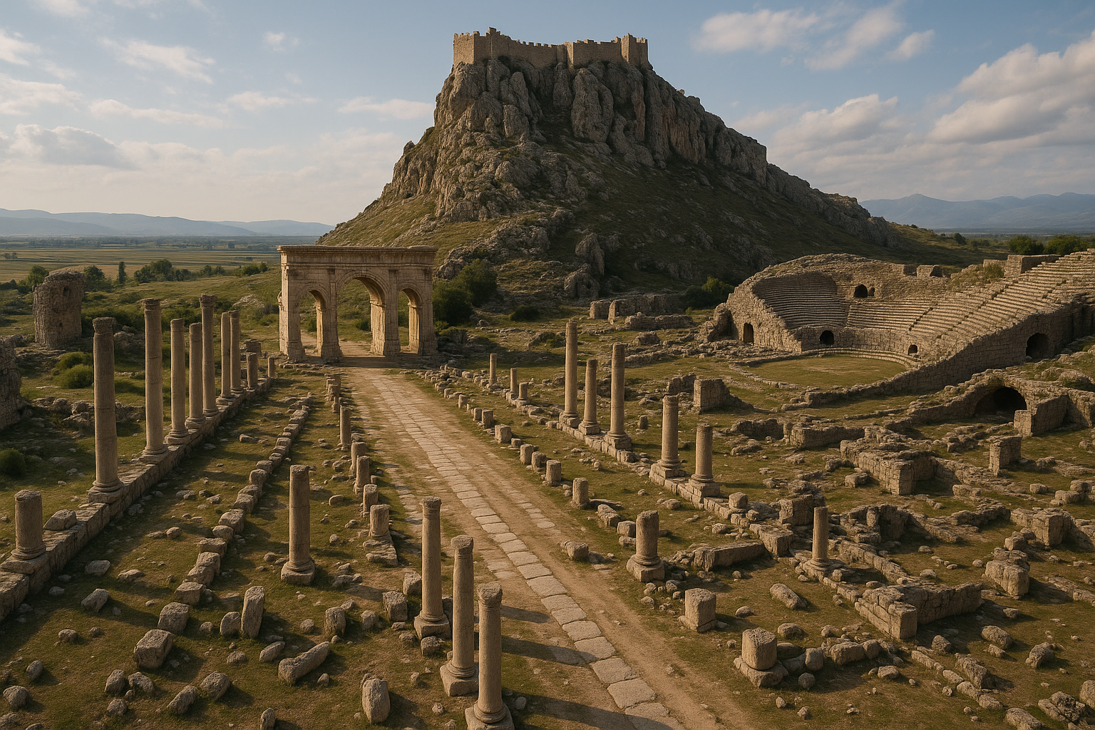
Carrefour stratégique : La cité contrôlait le plus important passage fluvial sur le Ceyhan le long de l'ancienne grande route reliant les Portes ciliciennes (le col à travers les monts Taurus depuis l'Anatolie centrale) à la Syrie et à la Mésopotamie. Chaque armée, caravane commerciale et pèlerin se déplaçant entre l'Anatolie et le Levant passait par Mopsueste ou à proximité. Cela en faisait l'un des sites les plus continuellement occupés de Cilicie.
Le pont romain : Le pont de Misis est l'un des plus beaux ponts romains subsistants de Turquie, construit à l'origine au IVe siècle apr. J.-C. et toujours debout avec une grande partie de sa structure d'origine. Ses neuf arches enjambent le fleuve Ceyhan et représentent un chef-d'œuvre du génie civil romain adapté à un fleuve puissant.
La mosaïque de l'Arche de Noé : Découverte en 1956, cette extraordinaire mosaïque de sol provenant d'une église du IVe siècle représente des scènes de l'histoire de l'Arche de Noé — l'une des plus anciennes représentations artistiques connues de ce récit biblique sous forme de mosaïque. C'est un jalon de l'art chrétien primitif.
7 000 ans d'occupation : Le Misis Höyük (tell d'habitat) contient des couches archéologiques allant du Néolithique à l'époque ottomane, ce qui en fait l'un des sites continuellement habités les plus longuement de la plaine de Çukurova (Cilicie).
Christianisme primitif : Mopsueste fut un évêché important et le siège de Théodore de Mopsueste (vers 350–428 apr. J.-C.), l'un des théologiens les plus influents de l'Église primitive, dont les commentaires bibliques ont façonné le christianisme nestorien.
Géographie et position stratégique
Mopsueste se trouve sur la rive orientale du fleuve Ceyhan (l'antique Pyramos), à environ 27 km à l'est d'Adana dans le district de Yüreğir. Le site occupe une position sur la fertile plaine de Çukurova (l'ancienne plaine aléienne) — l'une des régions agricoles les plus productives de Turquie, arrosée par les fleuves Seyhan et Ceyhan.
L'importance de la cité était déterminée par son contrôle du passage fluvial. Le Ceyhan est l'un des plus grands fleuves du sud de la Turquie, et les anciennes routes entre les Portes ciliciennes et la Syrie devaient le franchir. Mopsueste commandait le point de passage le plus pratique, là où le fleuve était assez étroit pour un pont permanent mais suffisamment large pour empêcher tout passage à gué facile ailleurs.
Le Misis Höyük — le tell d'habitat antique — s'élève de façon proéminente au-dessus de la plaine environnante, visible à une distance considérable. À environ 25 mètres au-dessus de la plaine, le tell représente des milliers d'années d'accumulation de débris d'habitat.
Le climat est méditerranéen, chaud et humide en été, doux en hiver, la plaine environnante soutenant une agriculture intensive — coton, agrumes et céréales — comme elle le fait depuis des millénaires.
Contexte historique
Fondation légendaire
Selon la mythologie grecque, Mopsueste fut fondée par Mopsos (en grec : Μόψος), devin et héros légendaire qui erra à travers la Cilicie et le Levant après la chute de Troie. Le nom « Mopsueste » signifie « foyer de Mopsos » (Μόψου ἑστία). Bien que la fondation légendaire soit mythologique, elle reflète des souvenirs authentiques de la colonisation grecque ancienne en Cilicie.
Âge du Bronze et période hittite
Le Misis Höyük montre des preuves d'occupation depuis le Néolithique (vers le Ve millénaire av. J.-C.). Pendant le Bronze récent (vers 1600–1200 av. J.-C.), la région faisait partie du Kizzuwatna, un royaume semi-indépendant allié à l'Empire hittite. Après l'effondrement de l'Empire hittite (vers 1200 av. J.-C.), la région devint partie du royaume néo-hittite de Qué (Cilicie).
Périodes assyrienne et perse
L'Empire assyrien intégra la Cilicie aux VIIIe-VIIe siècles av. J.-C.. Sous la domination perse (à partir de vers 539 av. J.-C.), Mopsueste faisait partie de la satrapie de Cilicie, gouvernée depuis Tarse.
Période hellénistique
Après le passage d'Alexandre le Grand par la Cilicie (333 av. J.-C.), Mopsueste fit partie du royaume séleucide. La cité fut refondée sous le nom de Séleucie du Pyramos sous la domination séleucide, bien que le nom plus ancien ait persisté.
Période romaine
Sous la domination romaine, Mopsueste prospéra comme station clé sur la grande route est-ouest reliant Tarse à Antioche. La cité fut élevée au rang de colonie romaine et frappa sa propre monnaie. Le grand pont romain fut construit durant cette période, et la cité reçut d'importants édifices publics.
Période byzantine
Mopsueste devint un évêché chrétien important dès le IVe siècle. L'évêque le plus célèbre de la cité, Théodore de Mopsueste (évêque de 392 à 428), fut un représentant majeur de l'école antiochienne d'interprétation biblique. Plusieurs églises aux sols de mosaïque élaborés furent construites durant cette époque.
Raids arabes et zone frontalière
À partir du VIIe siècle, Mopsueste devint partie de la volatile zone frontalière arabo-byzantine. La cité changea de mains à plusieurs reprises entre le Califat abbasside et l'Empire byzantin. Les Arabes connaissaient la cité sous le nom d'al-Massisa (المصيصة) et la fortifièrent comme bastion frontalier.
Royaume arménien de Cilicie
Aux XIe-XIVe siècles, Mopsueste faisait partie du Royaume arménien de Cilicie (Arménie cilicienne). Les Arméniens la connaissaient sous le nom de Msis (Մdelays). Durant cette période, la cité servit de centre urbain important dans le royaume arménien.
Période des croisades
Les armées croisées traversèrent Mopsueste durant la Première Croisade (1097–1099) et les campagnes suivantes. La cité fut disputée entre les États croisés et les pouvoirs locaux.
Période ottomane
Sous la domination ottomane (à partir du XVe siècle), l'établissement se réduisit à un petit village appelé Misis ou Yakapınar. Le pont romain continua à servir de principal passage fluvial.
Le pont romain
Le pont de Misis (Misis Köprüsü) est l'un des ponts romains subsistants les plus impressionnants de Turquie :
Construction
- Construit à l'origine sous l'empereur Constance II (r. 337–361 apr. J.-C.) au IVe siècle
- Restauration majeure par l'empereur Justinien Ier (r. 527–565 apr. J.-C.) au VIe siècle
- Réparations ultérieures aux époques médiévale et ottomane
Architecture
- Neuf arches enjambant le fleuve Ceyhan (structure d'origine ; certaines arches ont été modifiées au fil du temps)
- Longueur totale d'environ 200 mètres
- Construit en pierre de taille (maçonnerie en appareil) avec des arches arrondies
- Avant-becs (saillies triangulaires) sur le côté amont pour dévier le courant du fleuve
- Le pont démontre une ingénierie hydraulique romaine sophistiquée adaptée à un fleuve puissant et sujet aux inondations
Signification historique
Le pont était un élément d'infrastructure critique — il portait la principale route est-ouest reliant Tarse et Adana à Antioche et aux provinces orientales. Son usage continu du IVe siècle jusqu'à l'époque moderne (plus de 1 600 ans) en fait l'un des ponts les plus longtemps en service au monde.
État actuel
Le pont subsiste dans un état substantiellement intact, bien que le trafic des véhicules ait été dévié vers un pont moderne à proximité. Des travaux de conservation ont été entrepris pour stabiliser la structure.
La mosaïque de l'Arche de Noé
La mosaïque de l'Arche de Noé est le trésor artistique le plus célèbre de Mopsueste :
Découverte
Découverte en 1956 lors de fouilles archéologiques dirigées par Ludwig Budde (un archéologue allemand travaillant avec le musée d'Adana), la mosaïque fut trouvée dans le sol d'une basilique du IVe siècle apr. J.-C. (église chrétienne primitive) sur le Misis Höyük.
Description
La mosaïque représente des scènes de l'histoire biblique de Noé et du Déluge (Genèse 6–9) :
- L'Arche de Noé représentée comme un vaisseau en bois en forme de coffre
- Des animaux sortant de l'Arche par paires — notamment des oiseaux, des quadrupèdes et d'autres créatures
- Noé et sa famille représentés dans la manière stylisée de l'Antiquité tardive
- Les eaux du Déluge représentées par des motifs ondulés bleus
- L'ensemble de la scène encadré par des bordures géométriques et végétales
Signification artistique
La mosaïque de l'Arche de Noé est l'une des plus anciennes représentations connues de ce récit biblique sous forme de mosaïque. Elle fournit des preuves inestimables pour :
- Le développement de l'iconographie chrétienne primitive en Cilicie
- La transition des thèmes artistiques païens aux thèmes chrétiens au IVe siècle
- La sophistication des ateliers de mosaïque dans les villes provinciales (pas seulement les grands centres comme Antioche)
- La manière dont les récits bibliques étaient visualisés aux premiers siècles du christianisme
Emplacement actuel
La mosaïque est exposée au Musée de la Mosaïque de Misis, abrité dans un ancien bâtiment ecclésiastique sur le site.
Musée de la Mosaïque de Misis
Le Musée de la Mosaïque de Misis (Misis Mozaik Müzesi) est l'un des premiers musées de site spécialement construits de Turquie :
- Ouvert en 1959, à peine trois ans après la découverte de la mosaïque
- Abrité dans un bâtiment historique restauré (une ancienne structure d'église/médersa près du pont)
- Expose la mosaïque de l'Arche de Noé et la mosaïque de Samson comme pièces maîtresses
- Contient également de plus petits fragments de mosaïque, des pièces architecturales et des artefacts provenant des fouilles du Misis Höyük
- Le musée représente un exemple précoce de préservation in situ — conservant les découvertes archéologiques à proximité de leur lieu de découverte d'origine
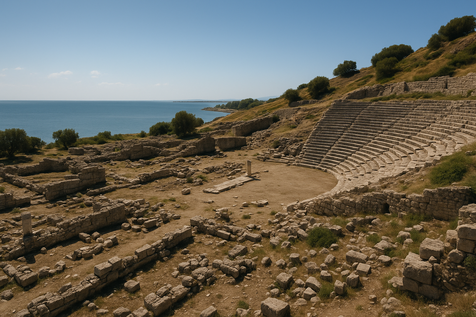
La mosaïque de Samson
Une seconde mosaïque majeure provenant de la basilique de Misis représente des scènes de l'histoire de Samson (Juges 13–16) :
- Samson et le lion : Samson déchirant un lion à mains nues
- Samson et les Philistins : Scènes de ses conflits avec les Philistins
- Exécutée dans un style antique tardif similaire à celui de la mosaïque de Noé
- Avec la mosaïque de Noé, elle démontre que la basilique de Misis possédait un vaste programme de mosaïques narratives de l'Ancien Testament — chose inhabituelle pour cette période et cette région
Autres caractéristiques archéologiques
Le tell (Höyük)
Le Misis Höyük est un grand tell d'habitat d'environ 25 mètres de hauteur couvrant plusieurs hectares. Il contient des couches d'occupation stratifiées allant du Néolithique à l'époque médiévale — plus de 7 000 ans d'occupation continue.
Remparts de la cité
Des vestiges fragmentaires de murs de fortification subsistent, datant de diverses périodes :
- Murs de l'époque hellénistique en pierre de taille
- Renforcements romains et byzantins
- Ajouts de la période arabe (lorsque Mopsueste était une forteresse frontalière)
Vestiges d'aqueduc
Des sections d'un aqueduc romain qui alimentait en eau la cité antique depuis les sources de montagne au nord ont été identifiées dans le paysage environnant.
Témoignages numismatiques
Mopsueste frappa sa propre monnaie durant la période romaine, fournissant des preuves importantes sur l'économie et l'identité civique de la cité. Les types monétaires incluent des représentations du dieu-fleuve Pyramos, des divinités tutélaires de la cité et des portraits impériaux.
Château médiéval
Un château médiéval (en partie arabe, en partie arménien) se dressait autrefois sur ou près du höyük, bien que peu subsiste hors sol. Des sources historiques décrivent des fortifications substantielles durant la période frontalière arabo-byzantine.
Mopsueste et le christianisme primitif
Mopsueste occupe une place spéciale dans l'histoire du christianisme primitif :
Théodore de Mopsueste (vers 350–428)
Le résident le plus célèbre de la cité fut Théodore, évêque de Mopsueste de 392 à 428. Il fut :
- Un représentant majeur de l'école antiochienne d'interprétation biblique, qui mettait l'accent sur le sens littéral et historique de l'Écriture (contrairement à l'approche allégorique de l'école alexandrine)
- Un commentateur prolifique qui écrivit sur presque tous les livres de la Bible
- Ses œuvres furent énormément influentes dans l'Église de l'Orient (Église nestorienne), qui le vénérait comme « l'Interprète »
- Posthume, il fut condamné lors du deuxième concile de Constantinople (553) pour des vues considérées comme proto-nestoriennes
- Malgré la condamnation, son héritage théologique a profondément façonné le christianisme oriental
Les mosaïques de la basilique
La basilique du IVe siècle avec ses mosaïques de Noé et de Samson démontre que Mopsueste possédait une communauté chrétienne riche et artistiquement sophistiquée à la fin de la période romaine. Le sujet vétéro-testamentaire des mosaïques reflète l'accent mis par l'école antiochienne sur le récit historique.
Siège épiscopal
Mopsueste était un évêché suffragant sous le métropolite de Tarse dans la province romaine de Cilicie Seconde. Les conciles ecclésiastiques attestent de la participation des évêques de Mopsueste du IVe au VIIe siècle.
Le Misis Höyük
Le tell d'habitat mérite une attention séparée comme l'un des sites multipériodes les plus importants de la plaine de Çukurova :
Couches chronologiques
- Néolithique (vers 5000 av. J.-C.) : Premières preuves d'habitat — poterie, outils en pierre
- Chalcolithique (vers 4000–3000 av. J.-C.) : Établissement en expansion avec traditions de poterie peinte
- Bronze ancien (vers 3000–2000 av. J.-C.) : Développement de caractéristiques urbaines
- Bronze moyen et récent (vers 2000–1200 av. J.-C.) : Période du Kizzuwatna et hittite — établissement fortifié
- Âge du Fer (vers 1200–550 av. J.-C.) : Royaume néo-hittite de Qué ; intégration assyrienne
- Périodes classique à byzantine (vers 550 av. J.-C.–700 apr. J.-C.) : Cité grecque, romaine et byzantine
- Période islamique (vers 700–1500) : Forteresse frontalière arabe, cité arménienne, village ottoman
- Ottomane (1500–1918) : Petit établissement autour du pont
Signification
La séquence d'occupation continue fait du Misis Höyük un site de référence stratigraphique clé pour la région de Çukurova, fournissant des données comparatives pour comprendre les schémas d'établissement à travers les millénaires.
Économie et routes commerciales
Le lien avec la Route de la Soie
Mopsueste se trouvait sur la principale route terrestre entre l'Anatolie centrale et le Levant :
- Les caravanes descendant par les Portes ciliciennes (col de Gülek) depuis la Cappadoce
- Traversaient la plaine de Çukurova via Tarse et Adana
- Traversaient le Ceyhan à Mopsueste sur le pont romain
- Continuaient vers l'est jusqu'à Issos, puis vers le sud à Antioche et la côte levantine, ou vers l'est jusqu'à la Mésopotamie
Cela faisait de Mopsueste un poste de douane et de péage naturel, générant des revenus du trafic commercial.
Agriculture
La plaine environnante de Çukurova était l'une des régions agricoles les plus productives du monde antique :
- Céréales (blé, orge) — le grenier de la Cilicie
- Coton — la Cilicie était connue pour la production de lin et de tissus
- Raisins et vin — la viticulture prospérait dans le climat doux
- Lin — utilisé pour la production de toile
Importance militaire
Le passage fluvial faisait de Mopsueste un point stratégiquement critique dans tout conflit militaire impliquant la Cilicie :
- Campagnes perses contre la Grèce
- Marche d'Alexandre le Grand vers Issos (333 av. J.-C.)
- Mouvements militaires romains vers la frontière orientale
- Guerre frontalière arabo-byzantine (VIIe-Xe siècles)
- Mouvements croisés à travers la Cilicie
Fouilles archéologiques
Exploration précoce
- Le pont romain attira l'attention des voyageurs et géographes européens à partir du XVIIIe siècle
- Victor Langlois décrivit le site dans son Voyage dans la Cilicie (1861)
Fouilles de Ludwig Budde (1956–années 1960)
- Ludwig Budde, travaillant avec le musée d'Adana, conduisit les fouilles les plus importantes
- Découvrit la mosaïque de l'Arche de Noé (1956) et la mosaïque de Samson dans la basilique du IVe siècle
- Ces découvertes conduisirent à la création du Musée de la Mosaïque de Misis (1959)
- Fouilla également des portions du höyük, établissant la chronologie de base de l'habitat
Travaux ultérieurs
- Les archéologues turcs ont poursuivi périodiquement des travaux de fouille et de conservation
- Les efforts de conservation se sont concentrés sur le pont romain et le musée de la mosaïque
- Le höyük demeure largement non fouillé — seule une petite fraction du tell a été systématiquement étudiée
- Les prospections géophysiques ont suggéré la présence de structures enterrées substantielles à travers le site
Informations pour les visiteurs
Localisation : Quartier de Misis (Yakapınar), district de Yüreğir, province d'Adana. À environ 27 km à l'est du centre-ville d'Adana sur l'autoroute D-400.
Accès : En voiture depuis Adana (30 minutes vers l'est sur l'autoroute D-400/E-5). Le site est directement adjacent à la route principale. Les bus municipaux d'Adana et les services de dolmuş atteignent Misis/Yakapınar. Adana possède un aéroport international avec des liaisons nationales et internationales.
Horaires : Le Musée de la Mosaïque de Misis est ouvert tous les jours, généralement de 08h30 à 17h30 (les horaires peuvent varier selon la saison). Le pont romain et la zone du höyük sont accessibles à tout moment.
Entrée : Petits frais d'entrée pour le musée. Le pont et la zone du tell sont gratuits.
Durée : 1 à 2 heures pour le musée, le pont et le tell. Prévoyez plus de temps si vous explorez le paysage plus large.
Visites combinées :
- Adana — Musée archéologique d'Adana (vaste collection provenant des sites ciliciens), Taşköprü (pont romain sur le Seyhan), mosquées historiques et bazar couvert
- Yılankale — château croisé/arménien spectaculaire sur une crête rocheuse, visible depuis l'autoroute (20 km à l'est)
- Anazarbe (Anavarza) — grande cité romaine/byzantine avec arc de triomphe, stade et forteresse rupestre (40 km au nord-est)
- Karatepe-Aslantaş — citadelle néo-hittite avec inscriptions bilingues (90 km au nord-est)
Conseils :
- Visitez d'abord le musée de la mosaïque pour comprendre la signification du site avant d'explorer le pont et le tell
- Le pont romain est mieux photographié depuis le pont moderne ou depuis la berge du fleuve
- Le höyük offre des vues panoramiques sur la plaine de Çukurova
- Le printemps (mars-mai) est la saison la plus agréable pour visiter
- Combinez avec Yılankale et Anazarbe pour une journée complète d'archéologie cilicienne
- Le Musée archéologique d'Adana fournit un excellent contexte pour comprendre la région
Foire aux questions
Pour quoi Mopsueste est-elle célèbre ? Mopsueste est surtout connue pour son pont romain sur le fleuve Ceyhan, la mosaïque de l'Arche de Noé (l'une des plus anciennes représentations connues en mosaïque), et son rôle de cité-carrefour stratégique sur la route entre l'Anatolie et la Syrie.
Qui était Mopsos ? Mopsos était un devin et héros grec légendaire qui, selon le mythe, erra à travers la Cilicie après la guerre de Troie et fonda plusieurs cités, dont Mopsueste (« foyer de Mopsos »). Les chercheurs modernes relient cette légende à la colonisation grecque ancienne de la Cilicie.
Qu'est-ce que la mosaïque de l'Arche de Noé ? Une mosaïque de sol du IVe siècle apr. J.-C. provenant d'une basilique chrétienne primitive à Misis, représentant des scènes de l'histoire biblique de Noé et du Déluge. Découverte en 1956, c'est l'une des plus anciennes représentations en mosaïque de ce récit et elle est exposée au Musée de la Mosaïque de Misis.
Qui était Théodore de Mopsueste ? Théodore (vers 350–428 apr. J.-C.) était l'évêque de Mopsueste et un théologien majeur de l'Église primitive. Il fut la figure de proue de l'école antiochienne d'interprétation biblique et a profondément influencé l'Église de l'Orient (christianisme nestorien).
Peut-on traverser à pied le pont romain ? Oui, le pont est accessible à pied. Le trafic des véhicules a été redirigé vers un pont moderne à proximité, faisant du pont antique un monument piétonnier.
Quel âge a l'établissement ? Le Misis Höyük contient des preuves d'habitat depuis environ 5000 av. J.-C. (Néolithique), ce qui fait de l'établissement un site vieux de plus de 7 000 ans. La cité connue sous le nom de Mopsueste date du Ier millénaire av. J.-C.
Mesures architecturales : Le pont romain
Le pont de Misis (Misis Köprüsü) a été documenté en détail à travers plusieurs campagnes de conservation. Le tableau suivant résume ses principales données structurelles.
| Caractéristique | Mesure / Détail |
|---|---|
| Longueur totale | ~200 m enjambant le fleuve Ceyhan |
| Nombre d'arches | 9 (configuration d'origine) |
| Type d'arche | En plein cintre (arches en berceau romaines) |
| Matériau de construction | Maçonnerie en pierre de taille |
| Avant-becs | Saillies triangulaires sur les piles amont pour dévier le courant de crue |
| Construction d'origine | Règne de Constance II (r. 337–361 apr. J.-C.), IVe siècle |
| Première restauration majeure | Empereur Justinien Ier (r. 527–565 apr. J.-C.), VIe siècle |
| Rénovations ultérieures | 743 apr. J.-C. et 840 apr. J.-C. (période arabe) ; autres réparations ottomanes |
| Liste indicative de l'UNESCO | Soumis par la Turquie sous le nom de « Pont de Justinien » |
Importance technique :
- Le pont démontre une ingénierie hydraulique romaine sophistiquée adaptée à l'un des fleuves les plus puissants et les plus sujets aux inondations du sud de la Turquie
- Les avant-becs triangulaires réduisent la pression de l'eau sur les piles lors des crues printanières, lorsque le débit du Ceyhan peut être multiplié par dix
- La conception à neuf arches répartit la charge sur plusieurs travées, réduisant le risque d'effondrement catastrophique en cas de défaillance d'une seule arche
- Usage continu du IVe siècle au XXe siècle — plus de 1 600 ans — en fait l'un des ponts les plus longtemps en service au monde
Témoignages numismatiques
Le monnayage de Mopsueste offre des preuves uniquement détaillées sur l'histoire politique, l'identité civique et l'infrastructure de la cité.
La monnaie du pont de Valérien (vers 255–256 apr. J.-C.) :
- Une monnaie locale en bronze frappée sous l'empereur Valérien (r. 253–260 apr. J.-C.) représente le pont du Pyramos sur son revers
- La monnaie montre un pont à cinq arches (reflétant soit une configuration antérieure, soit un rendu artistique abrégé)
- Au-dessus du pont, la figure couchée du dieu-fleuve Pyramos apparaît dans le champ
- Les lettres grecques épellent ΔΩΡΕΑ (dorea, « don »), indiquant que le pont était une donation impériale à la cité
- À chaque extrémité du pont, des arcs de triomphe sont représentés, suggérant que des portails monumentaux flanquaient le passage
Variantes du nom de la cité sur les monnaies :
| Souverain / Période | Nom de la cité sur les monnaies | Témoignage |
|---|---|---|
| Hadrien (r. 117–138) | ΑΔΡΙΑΝΗ (Hadriana) | Renommée en l'honneur de la visite d'Hadrien |
| Dèce (r. 249–251) | ΔΕΚΙΑ (Decia) | Renommage honorifique temporaire |
| Valérien (r. 253–260) | ΜΟΨΟΥΕΣΤΙΑ | Forme grecque standard restaurée |
| Gallien (r. 253–268) | ΜΟΨΟΥ | Forme abrégée |
Types monétaires et iconographie :
- Les types d'avers courants comprennent des portraits impériaux avec des légendes latines ou grecques
- Les types de revers présentent le dieu-fleuve Pyramos (couché avec une urne d'eau), Athéna, Tyché (fortune de la cité) et le pont
- La persistance de l'iconographie du dieu-fleuve reflète l'importance centrale du fleuve Ceyhan pour l'identité et l'économie de la cité
- Les monnaies de Mopsueste circulaient largement à travers la Cilicie et jusqu'en Syrie voisine
Les mosaïques de la basilique : Détails techniques
La basilique du IVe siècle qui a livré les mosaïques de l'Arche de Noé et de Samson a fait l'objet d'un débat savant concernant son affiliation religieuse.
Mosaïque de l'Arche de Noé — composition :
- La scène centrale représente une arche en forme de coffre sur quatre pieds, avec un couvercle ouvert portant l'inscription grecque ΚΙΒΩΤΟC ΝΩΕ ΤΟΥ ΔΙΚΑΙΟΥ (« Arche de Noé le Juste »)
- Un anneau extérieur d'animaux entoure l'arche — des quadrupèdes représentés par paires, marchant vers ou loin du vaisseau
- Un anneau intérieur d'oiseaux encadre les abords immédiats de l'arche
- Les eaux du déluge sont représentées par des tesselles ondulées bleu-vert sous l'arche
- Des bordures géométriques et végétales encadrent l'ensemble de la composition
Débat savant :
- Ludwig Budde (le fouilleur) identifia le bâtiment comme une basilique chrétienne du IVe siècle (église)
- L'érudition récente a remis en question cette identification, notant que l'usage exclusif d'imagerie vétéro-testamentaire (Arche de Noé et Samson) sans aucune scène néotestamentaire ou christologique pourrait indiquer une synagogue
- La présence de l'inscription grecque sur l'arche soutient une communauté hellénophone, compatible avec l'une ou l'autre institution
- Le consensus actuel reste divisé ; les mosaïques précèdent probablement 423 apr. J.-C. (lorsque l'empereur Théodose II interdit la construction de nouvelles synagogues)
Chronologie des fouilles
| Année(s) | Directeur / Institution | Activités clés |
|---|---|---|
| 1861 | Victor Langlois | Première documentation européenne du site dans Voyage dans la Cilicie |
| 1956 | Ludwig Budde (musée d'Adana) | Découverte de la mosaïque de l'Arche de Noé dans le sol de la basilique |
| 1956–années 1960 | Équipe Budde | Fouille de la mosaïque de Samson ; sondage stratigraphique du höyük |
| 1959 | Direction turque des musées | Ouverture du Musée de la Mosaïque de Misis — l'un des premiers musées de site de Turquie |
| 2012–présent | Prof. Giovanni Salmeri (Mission italienne) | Recherche multidisciplinaire ; prospections géophysiques ; analyse de poterie |
| En cours | Musée d'Adana / équipes de conservation | Stabilisation du pont ; rénovation du musée ; prospection de surface du höyük |
Potentiel non fouillé :
- Seule une petite fraction du höyük de 25 mètres de hauteur a été systématiquement étudiée
- Les prospections géophysiques ont détecté des structures enterrées substantielles à travers le tell, suggérant que des édifices publics majeurs restent à découvrir
- Le centre-ville romain et byzantin — avec son forum, ses thermes et d'autres églises — reste presque entièrement non fouillé sous les couches supérieures du tell
Sources et lectures complémentaires
- Ludwig Budde, Antike Mosaiken in Kilikien (1969–72) — le rapport de fouille sur les mosaïques de Misis
- Strabon, Géographie, 14.5.8 — sur Mopsueste
- Theodor Mommsen, Provinces de l'Empire romain — sur la Cilicie romaine
- Robert W. Edwards, The Fortifications of Armenian Cilicia (1987)
- Théodore de Mopsueste, œuvres complètes (diverses éditions) — écrits théologiques
- Liste indicative de l'UNESCO — Misis / « Pont de Justinien » (soumis par la Turquie)
- Wikipédia, « Mopsueste » — vue d'ensemble complète
- Direction turque des musées — Musée de la Mosaïque de Misis
- CoinWeek, « Ancient Coin Series: Bridges on Ancient Coins » — analyse de la monnaie de Valérien
- Italiana.esteri.it, « Italian Mission in Misis (Turkey) » — rapports de fouille multidisciplinaires
- NGC Ancients, « River-Gods on Ancient Roman Coins » — numismatique du dieu-fleuve Pyramos