Resumen: Temnos (también escrita Temnus) fue una de las doce ciudades de la Liga Eolia, estratégicamente situada en las laderas del Dumanlı Dağı (la antigua Montaña Temno) dominando el valle del río Hermos (Gediz), cerca de la moderna aldea de Görece, distrito de Menemen, İzmir. Mencionada por Heródoto (I.149) como una de las colonias eolias originales, Temnos sirvió como ciudad-guarnición que controlaba la fértil llanura del Hermos y las rutas que conectaban la costa egea con las regiones interiores de Lidia. A pesar de su importancia histórica, el yacimiento permanece en gran medida sin excavar: una ciudad antigua «dormida» cuyas murallas, cisternas, cavidad teatral y cimientos en terraza aguardan una investigación sistemática. El Proyecto de Prospección Arqueológica de Temnos, lanzado en 2006 por Giuseppe Ragone (Università Roma Tre), ha empezado a revelar el trazado urbano de la ciudad mediante prospecciones geofísicas y documentación de superficie.
Tabla de contenidos
- Por qué importa Temnos
- Geografía y emplazamiento
- Antecedentes históricos
- La Liga Eolia
- Trazado urbano y monumentos
- Acuñación y economía
- El Proyecto de Prospección Arqueológica de Temnos
- Temnos en las fuentes antiguas
- Contexto regional: el oeste de Anatolia
- Información para el visitante
- Preguntas frecuentes
- Fuentes y lecturas complementarias
Por qué importa Temnos
Temnos es significativa por varias razones interrelacionadas:
Herencia eolia: Como una de las doce ciudades originales de la Liga Eolia --la laxa confederación de colonias griegas que poblaron la costa noroccidental de Asia Menor--, Temnos conserva un ejemplo en gran medida intacto de urbanización eolia. Mientras que muchas ciudades eolias (como Pérgamo o Esmirna) fueron transformadas posteriormente por el desarrollo helenístico y romano, Temnos conserva su carácter más antiguo.
Posición militar estratégica: La ubicación en la cima de una colina sobre el valle del río Hermos confería a la ciudad el control de una de las llanuras agrícolas y rutas comerciales más importantes del oeste de Anatolia. Esta función de guarnición se refleja en sus sustanciales murallas.
Potencial no excavado: Temnos es uno de los yacimientos antiguos no excavados más prometedores de la región de İzmir. Las prospecciones geofísicas han revelado murallas, cimientos de edificios y sistemas de terrazas bajo la superficie: una «cápsula del tiempo arqueológica» que aguarda excavación.
Atestación literaria: Múltiples fuentes antiguas mencionan a Temnos, desde Heródoto (siglo V a. C.) pasando por Estrabón (siglo I a. C./I d. C.) hasta Plinio el Viejo (siglo I d. C.), proporcionando un marco textual para comprender el yacimiento.
Geografía y emplazamiento
Temnos se localiza en las laderas del Dumanlı Dağı (históricamente Monte Temno), aproximadamente 8 km al noroeste de Menemen en la provincia de İzmir, cerca del moderno pueblo de Görece (también llamado Yanıkköy en algunas fuentes).
El yacimiento ocupa una posición elevada en cresta a una altitud aproximada de 400-500 metros, dominando vistas panorámicas sobre la llanura del río Hermos (Gediz), una de las zonas agrícolas más fértiles del oeste de Anatolia. El valle del Hermos servía como un importante corredor este-oeste que conectaba las ciudades portuarias egeas con el interior lidio y, en última instancia, con la red de la Vía Real persa.
Ventajas topográficas
- Terreno defensivo: Las laderas empinadas en múltiples lados proporcionaban una defensa natural, complementada por murallas construidas
- Suministro de agua: Manantiales naturales y cisternas excavadas en la roca proporcionaban agua para la guarnición y la población civil
- Hinterland agrícola: La rica llanura aluvial del río Hermos abajo sostenía una extensa agricultura: cereal, olivos y viticultura
- Rutas de comunicación: Las líneas visuales conectaban Temnos con otras ciudades eolias a lo largo de la costa y en el interior
El paisaje circundante transita de maquia mediterránea en las laderas bajas a bosques de pino a mayores altitudes. La zona sigue siendo en gran medida rural hoy, con olivares y agricultura a pequeña escala dominando la economía.
Antecedentes históricos
Fundación y período eolio (c. 1000-546 a. C.)
Temnos fue fundada como parte de la colonización eolia del oeste de Anatolia, tradicionalmente fechada en el período posterior al colapso del mundo micénico (c. 1100-900 a. C.). Heródoto la enumera entre las doce ciudades eolias originales (Historias I.149).
Los primeros siglos de Temnos están escasamente documentados, pero la ciudad presumiblemente participó en las redes culturales y económicas más amplias de la comunidad eolia, compartiendo dialecto, prácticas religiosas e instituciones políticas con sus ciudades hermanas.
Dominación lidia (c. 680-546 a. C.)
Como otras ciudades eolias, Temnos cayó bajo la influencia y finalmente el control del reino lidio con base en Sardes. Bajo los reyes Giges, Aliates y Creso, los lidios extendieron su autoridad sobre las ciudades griegas costeras al tiempo que generalmente permitían su autonomía interna.
Período persa (546-334 a. C.)
Tras la conquista de Lidia por Ciro el Grande en el 546 a. C., Temnos, junto con todas las ciudades griegas de Asia Menor, pasó bajo control persa (aqueménida). La ciudad fue administrada como parte de la satrapía de Lidia. Durante la Revuelta Jónica (499-494 a. C.), la participación de las ciudades eolias varió; el papel específico de Temnos no está documentado.
Período helenístico (334-133 a. C.)
Tras la liberación de las ciudades griegas por Alejandro Magno (334 a. C.), Temnos entró en el mundo helenístico. La ciudad pasó por las manos de varios reinos sucesores:
- Control antigónida inicialmente tras la muerte de Alejandro
- Control lisimaqueo tras la batalla de Ipsos (301 a. C.)
- Influencia seléucida en el siglo III a. C.
- Anexión pergamena bajo la dinastía Atálida, probablemente hacia mediados del siglo III a. C.
Bajo control pergameno, Temnos sirvió probablemente como guarnición fronteriza que protegía los accesos occidentales al reino de Pérgamo. Los Atálidas invirtieron fuertemente en infraestructura militar por todo su territorio.
Período romano (133 a. C. -- 395 d. C.)
Cuando Átalo III legó el Reino de Pérgamo a Roma en 133 a. C., Temnos pasó a formar parte de la provincia romana de Asia. La ciudad continuó funcionando como pequeño centro urbano, aunque fue cada vez más eclipsada por el rápido crecimiento de la cercana Esmirna (la moderna İzmir), que se convirtió en una de las mayores ciudades del Asia romana.
Temnos acuñó su propia moneda de bronce durante el período romano, atestiguando una identidad cívica continuada y la autonomía local. Las monedas de época romana de Temnos representan diversas deidades, incluidos Dioniso (reflejando la economía vitivinícola de la región) y Tique (la diosa protectora de la ciudad).
Antigüedad tardía y abandono
La ciudad parece haber declinado gradualmente durante la Antigüedad tardía (siglos IV-VII d. C.). Las razones probablemente incluyeron la centralización de población y recursos en los grandes centros urbanos (Esmirna, Pérgamo), la disrupción de las redes comerciales regionales y posiblemente daños sísmicos: el valle del Hermos se halla en una zona sísmica activa.
La Liga Eolia
Temnos fue una de las doce ciudades de Eolia enumeradas por Heródoto (Historias I.149):
- Cime (Namurt Limanı): la mayor y más importante ciudad eolia
- Larisa (cerca de Buruncuk)
- Neonteichos (cerca de Yanıkkale)
- Temnos (Görece/Dumanlı Dağı)
- Killa (ubicación discutida)
- Notion (cerca de Claros)
- Aigiroessa (ubicación incierta)
- Pitane (Çandarlı)
- Aigai (Nemrutkale)
- Mirina (Kalabaksarı)
- Grineion (cerca de Aliağa)
- Esmirna: posteriormente «robada» por los jonios (Heródoto I.150)
La Liga Eolia nunca fue tan políticamente cohesiva como la Liga Jónica al sur. Funcionó principalmente como una federación cultural y religiosa, centrada en santuarios y festivales compartidos. Los eolios hablaban un distintivo dialecto griego eolio (también el dialecto de los poetas Safo y Alceo de Lesbos) y compartían prácticas religiosas centradas en Apolo y Dioniso.
Heródoto observa que Esmirna fue originalmente una de las doce ciudades eolias, pero fue tomada por refugiados jonios de Colofón, reduciendo la liga a once, aunque la tradición de las «doce ciudades» persistió en la memoria literaria.
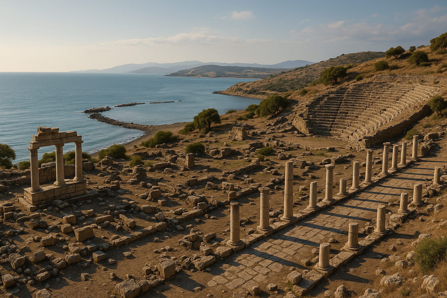
Trazado urbano y monumentos
Aunque la excavación sistemática aún no se ha llevado a cabo, las prospecciones de superficie y las investigaciones geofísicas han identificado varios rasgos clave:
Murallas urbanas
El rasgo visible más conservado es el circuito de murallas, partes del cual pueden rastrearse en las laderas del Dumanlı Dağı:
- Construidas con técnicas de mampostería poligonal y de sillería características del período helenístico
- El circuito amurallado encerraba una superficie sustancial en las laderas superiores
- Se han identificado cimientos de torres a intervalos a lo largo de la línea del muro
- La calidad sugiere inversión militar, posiblemente durante el período pergameno
Cavidad teatral
Se identificó una depresión natural en forma de teatro en la ladera durante las prospecciones de superficie:
- La cávea (área de asientos) probablemente explotaba la pendiente natural
- No son visibles elementos arquitectónicos (bloques de asientos, edificio escénico) en superficie
- La documentación completa requiere excavación
Cisternas y sistemas hídricos
Se han identificado varias cisternas excavadas en la roca:
- Esenciales para una ciudad-guarnición en altura sin una fuente natural de agua en cota
- Talladas en el lecho calizo
- Algunas muestran interiores enlucidos para la impermeabilización
Cimientos en terraza
Las prospecciones geofísicas (magnetometría y georradar) realizadas por el Proyecto Temnos han revelado:
- Cimientos rectangulares de edificios sobre plataformas aterrazadas
- Lo que puede ser una plataforma templaria en la terraza superior
- Alineamientos de calles o sendas que conectan distintos niveles de la ciudad
Evidencia cerámica
La cerámica de superficie recogida durante las prospecciones abarca múltiples períodos:
- Tiestos de los períodos arcaico y clásico (siglos VII-IV a. C.)
- Vajilla fina helenística y fragmentos de ánforas de transporte
- Cerámica de época romana, incluida la terra sigillata
- Esta secuencia cerámica confirma la habitación continua desde los períodos arcaico hasta el romano
Acuñación y economía
Temnos acuñó sus propias monedas durante los períodos helenístico y romano, proporcionando evidencia importante de la economía y la vida religiosa de la ciudad:
Acuñación helenística
- Pequeñas denominaciones de bronce para circulación local
- Representaciones de Dioniso (el dios del vino): reflejando la importancia de la viticultura en el valle del Hermos
- Iconografía de Apolo consistente con las tradiciones religiosas eolias
Acuñación imperial romana
- Monedas cívicas de bronce acuñadas bajo varios emperadores
- Los tipos de reverso incluyen a Tique (Fortuna/Diosa de la Ciudad), Asclepio (deidad sanadora) y Dioniso con uvas
- Algunas emisiones muestran acuñación de alianza (homonoia) con ciudades vecinas, documentando relaciones diplomáticas
- La acuñación continuada de moneda local hasta los siglos II-III d. C. muestra que la ciudad conservó sus instituciones cívicas incluso como pueblo romano menor
Economía agrícola
La llanura del Hermos era uno de los graneros del oeste de Anatolia:
- Cultivo de cereal en las tierras bajas aluviales
- Viticultura (producción de vino) en las laderas: confirmada por la iconografía dionisíaca de las monedas
- Cultivo de olivos por toda la región
- Pastoreo en las laderas superiores
El Proyecto de Prospección Arqueológica de Temnos
La investigación moderna más significativa en Temnos ha sido el Proyecto de Prospección Arqueológica de Temnos, iniciado en 2006 por el Profesor Giuseppe Ragone de la Università Roma Tre (Roma):
Metodología
- Prospección intensiva de superficie: recorrido sistemático del yacimiento para recoger y mapear cerámica, fragmentos arquitectónicos y otros hallazgos de superficie
- Prospección geofísica: estudios de magnetometría, resistividad y georradar para identificar rasgos subterráneos sin excavación
- Cartografía topográfica: modelos digitales detallados del terreno del yacimiento
- Documentación arquitectónica: registro y fotografía de líneas de muros visibles, cisternas y otros rasgos
Hallazgos clave
- Confirmación del circuito de murallas con torres y puertas
- Identificación de múltiples plataformas edilicias que sugieren un trazado urbano planificado
- Descubrimiento de una posible zona de ágora o plaza pública
- Documentación del sistema de gestión hídrica de la ciudad (cisternas, canales)
- Evidencia de habitación desde los períodos arcaico hasta el bizantino
Significación
El Proyecto Temnos es importante porque demuestra que los métodos arqueológicos no invasivos (prospecciones geofísicas) pueden revelar el trazado de una ciudad antigua sin excavación. Este enfoque preserva el yacimiento al tiempo que genera datos valiosos, un modelo para el estudio de yacimientos no excavados en toda Turquía.
Temnos en las fuentes antiguas
Varios autores antiguos mencionan a Temnos:
Heródoto (siglo V a. C.): Enumera a Temnos entre las doce ciudades eolias (Historias I.149). Esta es la referencia literaria conservada más temprana.
Jenofonte (siglo IV a. C.): En la Anábasis (VII.8.8), menciona la región de Temnos en conexión con los movimientos militares en el oeste de Anatolia.
Estrabón (siglo I a. C./I d. C.): En su Geografía (XIII.3.5), Estrabón localiza a Temnos en territorio eolio y describe su relación con el río Hermos y las ciudades vecinas.
Plinio el Viejo (siglo I d. C.): En la Historia Natural (V.30), Plinio enumera a Temnos entre las ciudades de la región eolia.
Esteban de Bizancio (siglo VI d. C.): Su léxico geográfico Ethnica incluye una entrada sobre Temnos con breves notas etnográficas.
Monedas e inscripciones: Más allá de las fuentes literarias, la existencia de la ciudad está confirmada por su acuñación (desde el período helenístico hasta el romano) y por inscripciones dispersas halladas en la región.
Contexto regional: el oeste de Anatolia
Temnos existió dentro de una densa red de ciudades antiguas en la región de İzmir:
Vecinos eolios:
- Cime (30 km al noroeste): la principal ciudad eolia, un gran puerto
- Pitane (50 km al norte, la moderna Çandarlı): ciudad eolia costera
- Mirina (40 km al norte): otra miembro de la liga
- Grineion (35 km al norte, cerca de Aliağa): sede de un oráculo de Apolo
Vecinos jonios:
- Esmirna (25 km al sur, la moderna İzmir): una de las mayores ciudades de la Antigüedad
- Focea (40 km al noroeste, la moderna Foça): la ciudad navegante jonia
Conexiones interiores:
- Sardes (80 km al este): la capital lidia sobre el río Hermos
- Pérgamo (70 km al norte): el reino helenístico que absorbió Temnos
Este denso paisaje urbano significaba que Temnos nunca fue una gran potencia independiente, sino más bien un nodo estratégico en una compleja red regional, controlando una ruta específica, vigilando un valle específico y contribuyendo a la capacidad militar y agrícola del poder mayor que la mantenía.
Información para el visitante
Ubicación: Cerca del pueblo de Görece, aproximadamente 8 km al noroeste del centro de Menemen, provincia de İzmir.
Cómo llegar: En coche desde İzmir (aproximadamente 40 minutos por la autopista İzmir-Çanakkale, saliendo en Menemen). Desde Menemen, siga las carreteras locales hacia el pueblo de Görece. El yacimiento antiguo está en las laderas sobre el pueblo. No hay transporte público regular al yacimiento.
Estado actual: El yacimiento no está desarrollado para el turismo: no hay taquillas, paneles informativos ni senderos señalizados. Los visitantes deberían tratar esto como una exploración arqueológica informal.
Terreno: Ladera empinada con suelo desigual, piedras sueltas y vegetación crecida en algunas zonas. Son esenciales unas botas de senderismo resistentes.
Duración: 1-2 horas para los restos visibles (murallas, cisternas, cavidad teatral).
Mejor temporada: Primavera (abril-mayo) y otoño (octubre-noviembre) por las temperaturas confortables y las flores silvestres. El verano puede ser extremadamente caluroso en la ladera expuesta.
Visitas combinadas:
- Menemen: la propia localidad tiene mezquitas de época otomana y un mercado animado
- Pérgamo (Bergama): 70 km al norte, uno de los mayores yacimientos arqueológicos de Turquía
- Cime (Namurt): la principal ciudad eolia, 30 km al noroeste (también en gran medida sin excavar)
- Ágora de İzmir: ágora de época romana en el centro de İzmir (45 minutos al sur)
Consejos:
- Esta es una visita aventurera, fuera de los caminos trillados: no es un yacimiento turístico pulido
- Lleve agua, protección solar y un mapa detallado o GPS
- Los lugareños pueden indicar las ruinas más visibles
- Las vistas sobre la llanura del Hermos son la recompensa, especialmente al atardecer
- Combine con una visita a Menemen por su famosa cocina local (el plato de huevos «menemen» tiene origen aquí)
Preguntas frecuentes
¿Qué fue Temnos? Una ciudad griega eolia fundada hacia comienzos del I milenio a. C. en una cima dominando el valle del río Hermos (Gediz) cerca de la moderna Menemen, İzmir. Fue una de las doce ciudades de la Liga Eolia.
¿Ha sido excavada? No se ha llevado a cabo ninguna excavación sistemática. El Proyecto de Prospección Arqueológica de Temnos (2006-actualidad) ha documentado los restos de superficie y ha empleado métodos geofísicos para cartografiar los rasgos subterráneos.
¿Qué se puede ver hoy? Partes de las murallas, cisternas excavadas en la roca, una cavidad teatral y fragmentos arquitectónicos dispersos en la ladera. El yacimiento está cubierto de vegetación y sin desarrollar.
¿Merece la pena visitarlo? Para los entusiastas de la arqueología y los viajeros aventureros, sí: la combinación de la historia eolia, el dramático emplazamiento en cima y la sensación de descubrir un yacimiento «intacto» es atractiva. Para los turistas generales que buscan yacimientos pulidos, la cercana Pérgamo es una mejor opción.
¿Por qué se llama Temnos? El nombre deriva probablemente de la palabra griega temnein (cortar), posiblemente refiriéndose al corte abrupto del terreno montañoso o a una cantera. La propia montaña se llamaba Monte Temno en la Antigüedad.
El terremoto del 17 d. C. y la ayuda imperial
Uno de los acontecimientos más precisamente fechados en la historia de Temnos es el devastador terremoto del 17 d. C., que ocurrió durante el reinado del emperador Tiberio y destruyó o dañó gravemente hasta quince ciudades de la provincia de Asia:
| Ciudad afectada | Provincia | Gravedad |
|---|---|---|
| Sardes | Lidia | Devastada (región del epicentro) |
| Filadelfia | Lidia | Gravemente dañada |
| Temnos | Eolia | Destruida |
| Magnesia del Sípilo | Lidia | Gravemente dañada |
| Apolonis | Lidia | Dañada |
| Tmolo | Lidia | Dañada |
| Kibyra | Frigia | Dañada |
| Mirina | Eolia | Dañada |
| Cime | Eolia | Dañada |
| Aigai | Eolia | Dañada |
El historiador romano Tácito (Anales II.47) ofrece el relato más detallado de este terremoto, señalando que ocurrió durante la noche y que la magnitud de la destrucción fue sin precedentes en la memoria viva. El emperador Tiberio respondió con importantes medidas de ayuda: una exención fiscal de cinco años para todas las ciudades afectadas y el envío de un comisario senatorial para evaluar los daños y coordinar la reconstrucción. Para Temnos, ya en declive en el período augústeo, este terremoto pudo haber sido un golpe terminal del que la ciudad nunca se recuperó totalmente.
El terremoto también proporciona un importante marcador estratigráfico para los arqueólogos que trabajan en Temnos y por toda la región. Cualquier capa de destrucción fechable a principios del siglo I d. C. puede correlacionarse potencialmente con este evento sísmico bien documentado.
Catálogo numismático: monedas de Temnos
La acuñación de Temnos abarca desde el período helenístico hasta la era imperial romana. La siguiente tabla cataloga los principales tipos conocidos:
| Período | Metal | Diámetro | Peso | Anverso | Reverso |
|---|---|---|---|---|---|
| Siglo III a. C. | Bronce (AE) | 12 mm | ~1,27 g | Cabeza barbada de Dioniso a la derecha, con corona de hiedra | Racimo de uvas en vid |
| Siglo III a. C. | Bronce (AE) | 17 mm | ~3,8 g | Cabeza coronada de Dioniso joven a la derecha | Racimo de uvas en vid, monograma a la izquierda |
| c. 200-100 a. C. | Bronce (AE) | 18-20 mm | ~4,5 g | Cabeza coronada de Dioniso a la derecha | Atenea Nikéfora en pie a la izquierda, sosteniendo racimo de uvas, lanza y escudo; letras D-H / T-A en el campo |
| c. 200-100 a. C. | Bronce (AE) | 16 mm | ~3,2 g | Cabeza de Atenea a la derecha, con yelmo | Ares en pie, sosteniendo lanza y escudo |
| Imperial romana | Bronce (AE) | 18-25 mm | Diverso | Retrato imperial (varios emperadores) | Tique en pie; Asclepio con báculo-serpiente; Dioniso con uvas |
El dominio aplastante de Dioniso en la acuñación de Temnos refleja la profunda conexión de la ciudad con la viticultura. El valle del Hermos fue una de las regiones productoras de vino más destacadas del oeste de Anatolia, y la vendimia era probablemente el acontecimiento económico más importante del ciclo anual. La representación de Atenea Nikéfora (Atenea Portadora de la Victoria) en algunas emisiones puede referirse al culto de Atenea en la cercana Pérgamo, reflejando el período del señorío atálida.
Varias emisiones de época romana muestran tipos de homonoia (alianza) con ciudades vecinas, documentando las relaciones diplomáticas que Temnos mantenía incluso como pueblo provincial menor. Estas monedas de alianza son evidencia valiosa para comprender la red de relaciones intercívicas en el Asia romana.
El culto de Apolo Kynneios
Trabajos académicos recientes han identificado a Temnos como el centro de un culto religioso significativo: el culto a Apolo Kynneios. Esta forma local de Apolo parece haber sido exclusiva de Temnos y sus inmediaciones:
- El culto elevó el estatus de Temnos a un nivel que podía rivalizar con Grineion, otra ciudad eolia famosa por su Oráculo de Apolo
- El epíteto «Kynneios» puede derivar de un topónimo local o de un aspecto específico del culto a Apolo en el yacimiento
- Los tipos monetarios con Apolo son consistentes con un importante culto cívico
- El culto probablemente atraía a fieles de las comunidades eolias vecinas, generando actividad económica vinculada a la peregrinación
Esta función religiosa ayuda a explicar por qué Temnos, a pesar de su tamaño relativamente pequeño, mantuvo instituciones cívicas y acuñó su propia moneda durante siglos. Una ciudad que albergaba un centro de culto significativo dominaba recursos y prestigio más allá de lo que justificaría su población por sí sola.
Fuentes y lecturas complementarias
- Heródoto, Historias I.149: la enumeración original de las ciudades eolias
- Estrabón, Geografía XIII.3.5: descripción geográfica
- Plinio el Viejo, Historia Natural V.30: referencia de época romana
- Tácito, Anales II.47: relato del terremoto del 17 d. C. que afectó a Temnos
- Giuseppe Ragone, «The Temnos Project: Preliminary Results» (Università Roma Tre, 2006-)
- Aeolis, Temnos -- WildWinds Ancient Coin Database
- CoinArchives -- Temnos search results
- OANNES Journal, «Some Notes on Aeolian Neonteichos and Temnos» (2024)
- BMC Troas, Aeolis, and Lesbos: catálogo de monedas antiguas de la región
- George Bean, Aegean Turkey (Londres, 1966): guía arqueológica regional
- Lista Indicativa de Patrimonio Mundial de la UNESCO -- Pérgamo y su paisaje cultural multi-estratificado (contexto regional)