Olba fue la capital del antiguo Reino de Olba, un poderoso centro religioso y administrativo de la Cilicia Áspera (Cilicia Tracheia) en el sur de Anatolia. Situada aproximadamente 4 km al este de Uzuncaburc (la antigua Diocesarea), la ciudad es famosa por su espectacular acueducto romano --de 150 metros de longitud y 25 metros de altura, que cruza el dramático cañón de Seytan Deresi (el Valle del Diablo)--, así como por su monumental ninfeo (edificio de fuente), su extensa necrópolis rupestre, los restos de un teatro y las ruinas de un monasterio paleocristiano. La dinastía de sacerdotes-reyes téucridos que gobernó desde Olba controlaba el importante Templo de Zeus en Diocesarea, creando una de las polities teocráticas más fascinantes del mundo antiguo. Las excavaciones lideradas por la Universidad de Mersin desde 2001 continúan descubriendo nuevas capas de este extraordinario yacimiento.
Tabla de contenidos
- Por qué importa Olba
- Geografía y emplazamiento
- Cronología histórica
- Principales monumentos
- Trabajos arqueológicos
- Información para el visitante
- Preguntas frecuentes
- Fuentes y lecturas complementarias
Por qué importa Olba
-
Capital de una dinastía teocrática única. Olba fue la sede de los sacerdotes-reyes téucridos, una dinastía sacerdotal hereditaria en la que cada gobernante varón recibía alternativamente el nombre de Ayax o Teucro (en honor a los legendarios héroes de la Guerra de Troya). Esta dinastía controló tanto la autoridad religiosa como política en la Cilicia Áspera durante siglos, una forma de gobierno notablemente rara en el mundo antiguo.
-
Obra maestra de la ingeniería hidráulica romana. El Acueducto de Olba, construido durante el reinado del emperador Septimio Severo (193-211 d. C.), es una asombrosa hazaña de ingeniería: 150 metros de largo y 25 metros de alto, cruzando el cañón de Seytan Deresi con dos niveles de arcos. Una inscripción en el acueducto reza «La Ciudad de los Olbanos», confirmando la identidad y el orgullo cívico de la ciudad.
-
Un sistema de ciudades gemelas con Diocesarea. Olba y la cercana Diocesarea (Uzuncaburc) funcionaban como centros complementarios: Diocesarea albergaba el sagrado Templo de Zeus Olbio, mientras que Olba servía como capital administrativa y residencial. La relación se asemeja al modelo Mileto-Dídima, donde un santuario sagrado se vinculaba a una ciudad gobernante.
-
Encrucijada del comercio cilicio. Situada al pie de los Montes Tauro en un afluente del río Calicadno (el moderno Goksu), Olba controlaba rutas clave que conectaban la costa cilicia con el interior anatolio.
-
Rica necrópolis y tradiciones funerarias. Las paredes del cañón de Seytan Deresi están jalonadas de tumbas rupestres, sarcófagos y monumentos funerarios que abarcan muchos siglos, ofreciendo un registro exhaustivo de las costumbres funerarias en la Cilicia Áspera.
Geografía y emplazamiento
Ubicación
Olba se encuentra en el interior montañoso al norte de Silifke en la provincia de Mersin, al pie de los Montes Tauro. El yacimiento se asienta en un afluente del río Calicadno (Goksu Nehri), en un paisaje de cañones profundos, mesetas calizas y fértiles valles de montaña.
Paisaje y topografía
La dramática topografía de Olba está definida por el cañón de Seytan Deresi (Valle del Diablo), un profundo cañón calizo que atraviesa el paisaje:
- El cañón: un cañón de paredes escarpadas de aproximadamente 25 metros de profundidad, que el acueducto romano cruza.
- La meseta: el área principal del asentamiento, sobre el terreno relativamente llano por encima y alrededor del cañón.
- Las laderas del valle: donde la necrópolis se extiende a lo largo de las paredes rocosas.
- Valle oriental: lugar de las ruinas del monasterio y de las terrazas agrícolas.
La geología caliza proporcionó un excelente material constructivo y facilitó la talla de tumbas rupestres y canales de agua.
Clima
El interior montañoso cilicio tiene un clima mediterráneo de altura: veranos cálidos y secos, e inviernos frescos, a veces nevados. La altitud modera el calor estival en comparación con la costa, lo que históricamente hizo de la zona un refugio atractivo del verano de las tierras bajas.
El eje Olba-Diocesarea
Los 4 km de separación entre Olba y Diocesarea estaban conectados por una carretera antigua, formando una unidad funcional:
- Diocesarea (Uzuncaburc): centro sagrado con el Templo de Zeus Olbio (construido c. 300 a. C. por Seleuco I Nicátor), una puerta monumental, una calle columnada y un teatro.
- Olba: capital administrativa con el acueducto, el ninfeo, el teatro, la necrópolis y las áreas residenciales.
- Los visitantes deberían planificar ver ambos yacimientos juntos para obtener la imagen completa de este antiguo sistema de ciudades gemelas.
Cronología histórica
| Período | Fechas aproximadas | Desarrollos clave |
|---|---|---|
| Prehelenístico (Pirindu) | Siglo VI a. C. y anteriores | Un reino local llamado Pirindu gobierna la zona; Olba es probablemente la capital |
| Helenístico / Seléucida | Siglos III-I a. C. | Seleuco I Nicátor reconstruye el Templo de Zeus en Diocesarea (c. 300 a. C.); los sacerdotes-reyes téucridos consolidan el poder |
| República romana | Siglo I a. C. | Cilicia entra en la órbita romana; la dinastía téucrida pasa de ser gobernante independiente a ser reyes clientes aliados de Roma |
| Imperio romano temprano | Siglos I-II d. C. | La ciudad prospera bajo la administración romana; los edificios cívicos se amplían |
| Período de apogeo (Severo) | Finales del siglo II -- inicios del III d. C. | Acueducto construido bajo Septimio Severo (193-211 d. C.); construcción del ninfeo; la ciudad alcanza su máximo desarrollo |
| Romano tardío / Bizantino temprano | Siglos IV-VI d. C. | Olba se convierte en obispado cristiano; se construye un monasterio; construcción de iglesias |
| Medieval | Siglos VII-XIV | Declive gradual; algunas estructuras se reutilizan |
| Otomano / Moderno | Siglo XV -- actualidad | Asentamiento rural; se desarrolla el interés arqueológico |
Los sacerdotes-reyes téucridos
La dinastía téucrida es una de las entidades políticas más intrigantes del mundo antiguo:
- Orígenes: la dinastía decía descender de los héroes mitológicos Teucro y Ayax, hijos de Telamón, que combatieron en Troya.
- Convención onomástica: cada gobernante varón se llamó alternativamente Teucro o Ayax a lo largo de las generaciones, una deliberada estrategia genealógica que vinculaba la dinastía a la mitología heroica.
- Doble papel: los téucridos sirvieron simultáneamente como sumos sacerdotes del Templo de Zeus Olbio en Diocesarea y como gobernantes políticos del territorio circundante, combinando la autoridad religiosa y la secular.
- Acuñación: los sacerdotes-reyes acuñaron sus propias monedas, que han sido cruciales para establecer la cronología de la dinastía.
- Declive: bajo la presión romana, la dinastía perdió gradualmente su autoridad independiente, transitando hacia el papel de gobernantes clientes antes de ser plenamente absorbida por el sistema provincial romano.
El Reino de Pirindu
Antes del período helenístico, la zona en torno a Olba estaba gobernada por un reino local llamado Pirindu, mencionado en fuentes hititas y posteriores. Se cree que Olba fue la capital de Pirindu, lo que hace que la significación política del lugar sea potencialmente mucho más antigua de lo que sugieren los restos griegos y romanos visibles.
El programa constructivo severiano
El reinado del emperador Septimio Severo (193-211 d. C.) marcó una gran inversión en la infraestructura de Olba:
- Construcción del acueducto monumental que cruza Seytan Deresi.
- Construcción del ninfeo adyacente al acueducto.
- Mejoras urbanas que reflejan el mecenazgo severiano más amplio de las ciudades romanas orientales.
- La inscripción «La Ciudad de los Olbanos» en el acueducto refleja la identidad y el orgullo cívico del período.
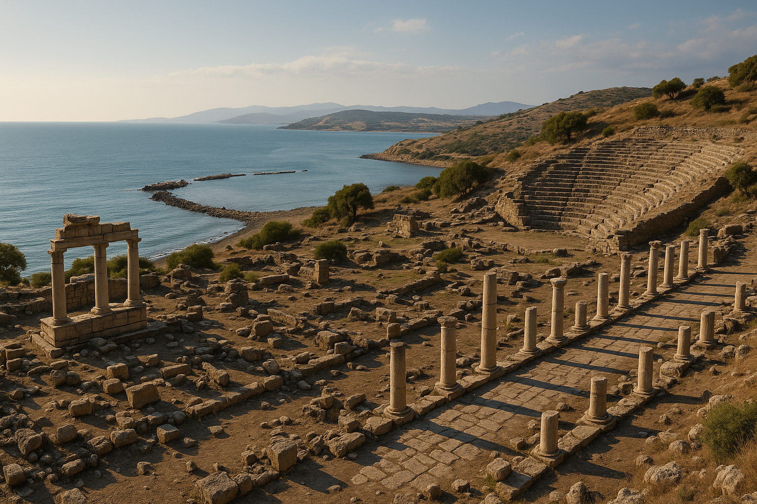
Principales monumentos
El acueducto
El Acueducto de Olba es el monumento más visualmente dramático y arquitectónicamente significativo del yacimiento.
- Longitud: aproximadamente 150 metros.
- Altura: aproximadamente 25 metros en el punto más profundo del cañón.
- Estructura: dos niveles de arcos que cruzan el cañón de Seytan Deresi.
- Fecha: reinado del emperador Septimio Severo (193-211 d. C.).
- Inscripción: lleva la inscripción «La Ciudad de los Olbanos» (Olbalilarin Kenti).
- Fuente de agua: traía agua del río Lamos (el moderno Limonlu) a través de un sistema de túneles y canales.
- Torres de guardia: se construyeron torres alrededor del acueducto para proteger esta infraestructura vital.
- Estado: notablemente bien conservado; arcos y mampostería en gran parte intactos; uno de los acueductos romanos supervivientes más finos del sur de Turquía.
La supervivencia del acueducto se debe en parte a su sólida construcción y en parte al aislamiento del cañón, que lo protegió del expolio de piedra. Caminar por el borde del cañón con el acueducto cruzando el abismo abajo es una de las experiencias más memorables de cualquier yacimiento antiguo en Cilicia.
Ninfeo (fuente monumental)
El ninfeo se alza adyacente al acueducto, sirviendo como punto ornamental de distribución del agua que este transportaba.
- Tipo: edificio de fuente monumental con fachada decorativa.
- Ubicación: junto al terminal del acueducto.
- Fecha: período severiano (finales del siglo II -- inicios del III d. C.).
- Rasgos: fachada con múltiples hornacinas típica de los ninfeos romanos; fragmentos arquitectónicos y tallas decorativas recuperados durante las excavaciones.
- Función: recibía agua del acueducto y la distribuía para uso público a la vez que servía como ornamento cívico y muestra del patronazgo imperial.
Teatro
Se han identificado fragmentos de un teatro en Olba, aunque está menos bien conservado que los teatros de la vecina Diocesarea.
- Elementos conservados: porciones del auditorio (cávea) y del edificio escénico (skene).
- Ubicación: se alza junto al ninfeo.
- Período: romano, probablemente del siglo II d. C.
- Aforo: de tamaño moderado, acorde con la población de la ciudad.
La necrópolis
La necrópolis de Olba se extiende a lo largo de las paredes del cañón de Seytan Deresi, creando uno de los cementerios situados de manera más dramática en Anatolia.
- Ubicación: a lo largo de las paredes del cañón, aprovechando las superficies rocosas naturales para la talla.
- Tipos de tumbas:
- Tumbas rupestres de cámara: talladas en la pared del acantilado con fachadas decoradas.
- Sarcófagos: ataúdes de piedra exentos, algunos con elaborada decoración en relieve.
- Monumentos construidos: edificios funerarios construidos de diversos tamaños.
- Rango de fechas: desde el período helenístico hasta el bizantino.
- Inscripciones: varias tumbas llevan inscripciones que identifican a los difuntos y aportan información genealógica.
- Significado: la ubicación junto al cañón crea un paisaje funerario visualmente impactante donde los muertos literalmente miraban hacia abajo a la ciudad de los vivos.
Complejo monástico
En el valle al este de la acrópolis, las ruinas de un sustancial monasterio paleocristiano se extienden por una amplia área.
- Período: romano tardío / bizantino temprano (aproximadamente siglos V-VII d. C.).
- Elementos: cimientos de iglesia, celdas residenciales, restos del refectorio, cisternas.
- Contexto: refleja la importancia de Olba como obispado cristiano: el obispo de Olba representó a la ciudad en los principales concilios y sínodos eclesiásticos.
- Ubicación: cerca del área del acueducto, lo que sugiere que el monasterio se benefició de la infraestructura de suministro de agua.
Murallas y acrópolis
- Acrópolis: un punto elevado fortificado que domina el asentamiento y el cañón.
- Muros defensivos: tramos de murallas de diversos períodos, que reflejan la larga historia defensiva del lugar.
- Puertas: trazas de puertas de la ciudad a lo largo de las principales rutas de acceso.
Trabajos arqueológicos
Historia de las excavaciones
- Exploración temprana: viajeros europeos del siglo XIX documentaron las ruinas visibles, particularmente el acueducto.
- Prospecciones académicas: diversos equipos turcos e internacionales realizaron prospecciones de superficie a lo largo del siglo XX.
- 2001-2009: primera fase de excavación sistemática bajo A. Emel Erten de la Universidad de Mersin.
- 2010-actualidad: continúa la excavación e investigación bajo el equipo de la Universidad de Mersin.
Descubrimientos clave
Las excavaciones de la Universidad de Mersin han producido resultados significativos:
- Estatua femenina de 1.800 años: restos de una estatua femenina de época romana descubierta, contribuyendo a la comprensión del programa escultórico de la ciudad.
- Fragmentos de friso: se han recuperado fragmentos que representan narraciones mitológicas, lo que indica la presencia de programas decorativos de alta calidad en los edificios públicos.
- Suelos de mosaico: mosaicos antiguos descubiertos en diversos contextos.
- Conjuntos cerámicos y numismáticos: que proporcionan evidencia cronológica detallada de las fases de ocupación de la ciudad.
- Documentación arquitectónica: registro sistemático del acueducto, el ninfeo y las estructuras de la necrópolis.
- Análisis del sistema hidráulico: estudio detallado de cómo los túneles, canales y el acueducto formaban una red hidráulica integrada.
Retos de conservación
- El entorno del cañón calizo somete las estructuras a la erosión por filtración de agua, ciclos de hielo y deshielo y crecimiento de vegetación.
- Algunas tumbas de la necrópolis requieren estabilización para evitar el colapso.
- El acueducto, aunque estructuralmente sólido, requiere monitorización continua.
- La infraestructura turística es mínima, lo que limita tanto el acceso de los visitantes como el argumento económico para invertir en conservación.
Información para el visitante
Ubicación y acceso
| Detalle | Información |
|---|---|
| Provincia | Mersin |
| Distrito | Silifke |
| Distancia desde el centro de Silifke | Aproximadamente 30 km al norte |
| Distancia desde Uzuncaburc (Diocesarea) | Aproximadamente 4 km al este |
| Distancia desde la ciudad de Mersin | Aproximadamente 120 km al oeste |
| Coordenadas GPS | Aproximadamente 36,62 N, 33,95 E |
Cómo llegar
- En coche desde Silifke: conduzca hacia el norte desde Silifke hacia Uzuncaburc. La carretera bien señalizada sube hacia las estribaciones del Tauro. Tras visitar Uzuncaburc, continúe aproximadamente 4 km al este hasta Olba.
- En coche desde Mersin: tome la autopista costera D400 hasta Silifke, luego siga el camino de Uzuncaburc hacia el norte. Viaje total de aproximadamente 2-2,5 horas.
- Visita combinada recomendada: planifique siempre visitar tanto Uzuncaburc (Diocesarea) como Olba juntas: están a solo 4 km de distancia e históricamente forman un único complejo.
Duración de la visita
- Solo Olba (visita rápida): 45 minutos a 1 hora.
- Olba con exploración detallada: 1,5-2,5 horas.
- Olba + Uzuncaburc combinadas: 3-5 horas (recomendado).
- Día completo con yacimientos circundantes: 6-8 horas incluyendo tiempo de viaje.
Mejor época para visitar
- Primavera (abril-mayo): condiciones ideales; paisaje verde, flores silvestres en el cañón, temperaturas cómodas.
- Otoño (septiembre-octubre): cálido pero agradable; excelente luz para fotografiar el acueducto.
- Verano: caluroso, pero más soportable que en la costa debido a la altitud. Visite a primera hora de la mañana.
- Invierno: fresco a frío; posible nieve a mayores altitudes. Los días claros de invierno ofrecen vistas dramáticas del cañón.
Consejos prácticos
- Calzado: calzado robusto esencial. El área del cañón tiene un terreno empinado e irregular.
- Seguridad en el cañón: extreme la precaución cerca de los bordes del cañón. No hay barreras de seguridad.
- Agua y suministros: lleve los suyos. La aldea de Uzuncaburc cuenta con servicios básicos; la propia Olba dispone de instalaciones muy limitadas.
- Fotografía: el acueducto que cruza el cañón se fotografía mejor desde el borde oriental con luz matutina. La luz vespertina ilumina la pared occidental del cañón y las tumbas de la necrópolis.
- Gestión del tiempo: no se apresure. La combinación de acueducto, cañón, necrópolis y ninfeo crea un paisaje que se aprecia mejor a un ritmo contemplativo.
- Admisión: consulte las tarifas de entrada actuales. Algunas áreas pueden requerir la misma entrada que Uzuncaburc.
Visitas combinadas
El área de Olba/Uzuncaburc combina excelentemente con otros yacimientos cilicios:
- Uzuncaburc (Diocesarea): la visita compañera esencial: Templo de Zeus Olbio, puerta monumental, calle columnada, teatro. A solo 4 km de Olba.
- Castillo de Silifke: impresionante fortaleza medieval que domina la localidad de Silifke y el valle del río Goksu.
- Cennet ve Cehennem (Cielo e Infierno): dramáticos sumideros con capilla bizantina y cueva, aproximadamente a 20 km al sur.
- Kizkalesi (Corico): castillo marítimo y castillo terrestre en la costa, aproximadamente a 60 km al este.
- Adamkayalar: figuras en relieve rupestre talladas en una pared de acantilado, aproximadamente a 15 km al sur.
Preguntas frecuentes
¿Cuál es la relación entre Olba y Uzuncaburc?
Eran un sistema de ciudades gemelas: Olba era la capital administrativa y centro residencial, mientras que Uzuncaburc (la antigua Diocesarea) era el centro sagrado que albergaba el Templo de Zeus Olbio. Los sacerdotes-reyes téucridos controlaban ambos lugares, y el camino de 4 km entre ellos era un eje procesional y administrativo. La relación es similar a cómo Mileto controlaba el lejano santuario de Dídima a través de una Vía Sagrada. Los visitantes deberían ver siempre ambos yacimientos para entender el sistema completo.
¿Quiénes fueron los sacerdotes-reyes téucridos?
Los téucridos fueron una dinastía hereditaria de sacerdotes-gobernantes que combinaban la autoridad religiosa (como sumos sacerdotes del Templo de Zeus) con el poder político sobre la Cilicia Áspera. Decían descender de los héroes de la Guerra de Troya Teucro y Ayax, y cada gobernante varón se llamaba alternativamente Teucro o Ayax. Acuñaron su propia moneda y gobernaron de manera semiindependiente hasta ser absorbidos gradualmente por el sistema provincial romano.
¿Es seguro acercarse al acueducto?
La estructura del acueducto en sí misma es estable, pero los bordes del cañón no están vallados y el terreno es empinado y rocoso. Permanezca en los senderos establecidos, mantenga una distancia segura del borde del cañón y extreme la precaución particularmente con los niños. No intente trepar por la estructura del acueducto.
¿Cómo se compara Olba con Uzuncaburc en términos de interés para el visitante?
Uzuncaburc está más extensamente excavado y tiene monumentos más inmediatamente accesibles (las columnas del templo de Zeus, la puerta monumental, el teatro). Olba ofrece una experiencia más agreste y aventurera, con el acueducto como pieza central y la necrópolis del cañón como un dramático rasgo paisajístico. Juntos ofrecen experiencias complementarias: Uzuncaburc por la arquitectura templaria monumental, Olba por la ingeniería hidráulica y los paisajes funerarios.
¿Puedo caminar entre Olba y Uzuncaburc?
Los 4 km de distancia son recorribles a pie, y en la Antigüedad esta era una importante carretera de conexión. Hoy la ruta sigue una carretera rural agradable para caminar con buen tiempo. Reserve aproximadamente 45-60 minutos a pie en cada sentido. Sin embargo, la mayoría de los visitantes conducen entre los dos yacimientos.
¿Fue Olba un importante centro cristiano primitivo?
Sí. Olba fue sede de un obispo cristiano desde finales del período romano en adelante. El obispo de Olba asistió a importantes concilios y sínodos eclesiásticos. Las sustanciales ruinas del monasterio al este de la acrópolis y la evidencia de construcción de iglesias confirman la importancia del lugar en la geografía cristiana primitiva de Cilicia.
Olba en el contexto más amplio de los paisajes sagrados cilicios
Olba y Diocesarea pertenecen a una red más amplia de centros sagrados y administrativos en la Cilicia Áspera:
- Diocesarea (Uzuncaburc): la contraparte sagrada de Olba con el Templo de Zeus Olbio, a 4 km al oeste.
- Seleucia ad Calycadnum (Silifke): la principal ciudad helenística y romana en la desembocadura del río Goksu.
- Korykos (Kizkalesi): ciudad fortaleza costera con castillos marítimo y terrestre.
- Kanytelleis (Kanlidivane): un yacimiento notable construido en torno a un gigantesco sumidero, con tumbas-torre helenísticas y un relieve romano.
- Cennet ve Cehennem: los famosos sumideros del Cielo e Infierno con una capilla bizantina.
- Elaiussa Sebaste (Ayas): importante ciudad costera con teatro, ágora y necrópolis.
Dentro de este paisaje, Olba-Diocesarea destaca por su modelo único de gobernanza teocrática, su estructura administrativa de ciudades gemelas y el dramático acueducto que cruza el cañón, rasgos no replicados en ningún otro yacimiento cilicio.
Glosario de términos clave
- Dinastía téucrida: la dinastía hereditaria de sacerdotes-reyes de Olba, llamada así por el héroe mitológico Teucro.
- Ninfeo: edificio monumental de fuente, a menudo elaboradamente decorado, que sirve como punto público de distribución de agua.
- Acueducto: conducto de agua de ingeniería, a menudo elevado sobre arcos, que transporta agua a distancia.
- Seytan Deresi: «Valle del Diablo»: el profundo cañón calizo que define la topografía de Olba.
- Diocesarea: «Ciudad de Zeus»: el asentamiento sagrado (la moderna Uzuncaburc) que albergaba el Templo de Zeus Olbio.
- Cilicia Áspera (Cilicia Tracheia): la sección montañosa occidental de la antigua Cilicia en el sur de Turquía.
- Calicadno: nombre antiguo del río Goksu que fluye por la región.
Evidencia numismática: monedas de los sacerdotes-reyes téucridos
La acuñación de Olba es una de las fuentes primarias para reconstruir la cronología y la autoridad de la dinastía téucrida. Dado que los sacerdotes-reyes acuñaron monedas con sus nombres y títulos, la evidencia numismática llena los vacíos dejados por el escaso registro literario.
Tipos de monedas conocidos
| Gobernante | Fecha aproximada | Metal / Tamaño | Anverso | Reverso | Rasgos destacados |
|---|---|---|---|---|---|
| Ayax, hijo de Teucro | c. 10-15 d. C. | Bronce, 22 mm, ~7,05 g | Busto drapeado a derecha con gorro sacerdotal; kerykeion (caduceo del heraldo) a la derecha | Triskeles (símbolo de tres piernas) | Describe a los súbditos como «pueblo de Cennatis y Lalassis» |
| Teucro (diversos) | Siglo I a. C. -- siglo I d. C. | Bronce | Busto con tocado sacerdotal | Rayo de Zeus o fachada de templo | Confirmada la convención onomástica alternante Teucro/Ayax |
| Emisiones cívicas anónimas de Olba | Comienzos del siglo II d. C. | Bronce | Personificación de la ciudad o retrato imperial | Torre almenada | Los habitantes representaron su torre de fortificación en la acuñación |
La torre almenada representada en la acuñación de Olba del siglo II d. C. se corresponde con ruinas de torre reales todavía visibles en el yacimiento. La elección de los habitantes de situar su fortificación en las monedas indica que la torre defensiva era una fuente de orgullo cívico y un emblema reconocible de la identidad de la ciudad.
Reconstrucción de la dinastía a partir de las monedas
La evidencia numismática ha sido esencial para establecer la sucesión de los sacerdotes-reyes:
- Teucro I (Taracyaris): el gobernante atestiguado más antiguo.
- Ayax I: hijo de Teucro I.
- Teucro II: hijo de Ayax I.
- La sucesiva alternancia de los nombres Ayax/Teucro continúa a lo largo de al menos seis generaciones documentadas.
- Transición final a la administración provincial romana bajo la dinastía flavia (finales del siglo I d. C.).
Templo de Zeus Olbio en Diocesarea: mediciones arquitectónicas
El Templo de Zeus Olbio en la cercana Diocesarea (a 4 km de Olba) fue el centro espiritual controlado por los sacerdotes-reyes téucridos. La documentación arquitectónica precisa proporciona un contexto crítico para entender la significación religiosa de Olba.
| Parámetro | Medida / Detalle |
|---|---|
| Tipo de templo | Períptero (rodeado de columnas) |
| Disposición de columnas | 6 x 12 columnas |
| Orden de columnas | Corintio: el templo períptero corintio más antiguo de Asia Menor |
| Fecha de construcción | c. 300 a. C., bajo Seleuco I Nicátor (r. 312-281 a. C.) |
| Constructor | Seleuco I Nicátor, confirmado por una inscripción descubierta por Rudolf Heberdey y Adolf Wilhelm |
| Témenos (recinto sagrado) | Patio rectangular que rodea el templo, restringido al acceso ceremonial |
| Conversión posterior | Iglesia (período bizantino), lo que contribuyó a la relativamente buena conservación del templo |
La identificación del patrocinador del templo como Seleuco I Nicátor fue establecida por el descubrimiento de una inscripción durante las exploraciones del siglo XIX por Heberdey y Wilhelm. La forma del capitel corintio aportó evidencia arquitectónica de datación adicional. Junto con el Templo de Zeus en Euromos, el templo de Diocesarea representa uno de los más finos ejemplos supervivientes de arquitectura períptera corintia en Asia Menor.
Cronología de excavaciones y línea temporal de descubrimientos
| Año / Período | Actividad | Equipo / Director | Resultados clave |
|---|---|---|---|
| Siglo XIX | Primera documentación europea | Heberdey, Wilhelm y diversos viajeros | El acueducto y las ruinas visibles fueron dibujados; descubrimiento de la inscripción de Seleuco I |
| 1970 | Declaración de protección estatal | Ministerio de Cultura turco | Yacimiento protegido formalmente; expolio de piedra reducido |
| 2001-2009 | Primera excavación sistemática | A. Emel Erten, Universidad de Mersin | Documentación del ninfeo; prospección de la necrópolis; despeje inicial de la acrópolis |
| 2010-actualidad | Excavación continuada | Equipo de la Universidad de Mersin | Estatua femenina de 1.800 años; fragmentos de friso con escenas mitológicas; suelos de mosaico; conjuntos cerámicos/numismáticos; cartografiado del complejo monástico |
| Década de 2020 | Análisis del sistema hidráulico | Universidad de Mersin | Estudio integrado de túneles, canales y acueducto como una única red de suministro de agua desde el río Lamos |
Ingeniería del acueducto: análisis técnico
El Acueducto de Olba es una obra maestra de la ingeniería hidráulica provincial romana. Las mediciones detalladas revelan la sofisticación de su diseño.
| Parámetro | Medida / Detalle |
|---|---|
| Vano total | ~150 metros a través del cañón de Seytan Deresi |
| Altura máxima | ~25 metros en el punto más profundo del cañón |
| Estructura | Dos niveles de arcos (arcada sobre arcada) |
| Fecha de construcción | Reinado de Septimio Severo, 193-211 d. C. |
| Inscripción dedicatoria | «La Ciudad de los Olbanos» (Olbalilarin Kenti) |
| Fuente de agua | Río Lamos (el moderno Limonlu Cayi) |
| Método de conducción | Túneles y canales abiertos que conducen al puente del acueducto |
| Rasgos defensivos | Torres de guardia construidas alrededor del acueducto para proteger el suministro de agua |
| Conservación | En gran parte intacto; arcos y mampostería sobreviven gracias al aislamiento del cañón, que impidió el expolio de piedra |
El diseño de doble arcada era necesario porque un único nivel de arcos no podría haber alcanzado los 25 metros de altura requeridos para mantener el gradiente del canal de agua a través del cañón. Las torres de guardia que rodean el acueducto son inusuales e indican que este suministro de agua se consideraba estratégicamente vital: su destrucción habría sido catastrófica para la ciudad.
Fuentes y lecturas complementarias
- Wikipedia -- Olba (ancient city)
- Wikipedia -- Olba Aqueduct
- Turkish Archaeological News -- Olba Site Profile
- Artichaeology -- Olba / Diocaesarea Ancient City
- Livius -- Olba-Diocaesarea
- Slow Travel Guide -- Olba Ancient Site
- EBSCO Research Starters -- Olba History
- Anatolian Archaeology -- 1,800-Year-Old Female Statue and Frieze Fragments Discovered at Olba
- Following Hadrian Photography -- Olba-Diocaesarea
- JAHA -- An Evaluation of the Olba Nymphaeum and Its Coins
- Mersin Provincial Directorate of Culture and Tourism -- Documentación oficial.