Termessos is the great paradox of Anatolian archaeology: a city of monumental theatres, gates, temples and tombs that has never, in the modern era, been the subject of a single systematic excavation. It stands at 1,050 metres on the shoulder of Güllük Dağı — the ancient Mount Solymos — in the Taurus range, thirty kilometres northwest of Antalya. The Pisidians who built it called themselves the Solymoi, and Homer remembered them in the Iliad as the proud warriors against whom Bellerophon was sent to die. They were not the kind of people to surrender a mountain. When Alexander the Great arrived beneath their walls in the spring of 333 BC, he looked up at the cliffs, the choke-point road, the towers, and the silent shields above and decided that this place was not worth the time of a siege. Arrian called it an eagle's nest. Alexander turned away. No conqueror would ever take Termessos by force. The city accepted Rome on its own terms, minted its own coins, built a theatre with a view that drops two kilometres down a valley to the Gulf of Antalya, and then, sometime in the 4th or 5th century AD, after the earthquakes that brought down the cisterns and the colonnades, it was simply left where it lay. The forest came back. The sarcophagi tilted where the ground heaved beneath them. Today you walk through a sleeping city: a theatre suspended over a chasm, gateways with their lintels still in place, a necropolis of broken stone scattered across pine-shaded slopes. For anyone wanting to escape the crowds of Antalya's coastal resorts, Termessos is the great hidden treasure of the Taurus.
- Why Termessos Matters
- Geography and Setting
- Historical Timeline
- Major Monuments
- Alexander and Termessos
- The Unexcavated City
- Mysteries of the Necropolis
- The Cistern System
- Numbers and Measurements
- Visitor Information
- Frequently Asked Questions
- Sources and Further Reading
Why Termessos Matters
Termessos is not famous in the way Ephesus is famous, or Aphrodisias, or Pergamon. It has no marble-paved high street where cruise tours queue for photographs. It has, instead, a rarer claim on the imagination: it is one of the very few cities of the ancient Mediterranean where the past has been left almost exactly as the past left it.
-
The city Alexander would not besiege. In the long career of the conqueror who marched from Macedonia to the Punjab and never lost a pitched battle, the moment beneath Termessos is one of only a handful where Alexander turned aside without a fight. Arrian's Anabasis Alexandri is explicit: the site was so strong that no army, however large, could profitably attack it. The Termessians were not defeated. They were simply not engaged.
-
A city never systematically excavated. This is, in modern archaeology, an extraordinary status. Across more than a century since its rediscovery, Termessos has been measured, drawn, photographed, surveyed and described — but no trench has ever been opened down to bedrock across a public building, and no stratigraphic record exists for the city as a whole. Whatever is hidden beneath the rubble is still hidden. The site is essentially a sealed archive.
-
A theatre with a view that stops conversation. The cavea is cut into the mountain at the lip of a chasm. Sit in the upper rows and the eye plunges down a forested gorge to the haze of the Mediterranean. No other Anatolian theatre is so vertically engaged with its landscape.
-
A Pisidian identity that never broke. Most of the famous cities of southern Anatolia are Greek or Roman foundations or refoundations. Termessos was Pisidian from beginning to end. Its chief god was Zeus Solymeus — Zeus reimagined in the image of the local mountain — and its civic culture, its inscriptions, its tomb forms, all retain a distinctly highland character.
-
A necropolis like nowhere else. Sarcophagi lie in the woods, tilted, cracked, half buried, in places where they appear to have fallen in a single instant. Some are inscribed with the fines payable for tomb violation; others bear the names of women who commissioned their own monuments. The cemetery is not arranged in tidy rows. It spreads across the mountain in the disorder of catastrophe.
-
A national park, not a museum. The ruins lie within Güllük Dağı Millî Parkı, declared in 1970, and the experience of visiting is closer to a wilderness hike than to a guided antiquity tour. There are wild goats among the columns. Eagles ride the thermals over the theatre.
-
The closest great escape from coastal Antalya. Thirty kilometres of road separate the beach hotels from a 1,050-metre Pisidian citadel of forests, cliffs, and ancient silence. The contrast is one of the most rewarding in Turkey.
-
The light, the silence, the scale. There is something about being a thousand metres up, with the Mediterranean spread out below and the cedar wind moving through a Roman theatre, that no coastal site can offer. The acoustics in the bouleuterion still work. The marble of the temple of Zeus Solymeus still catches the first morning sun. Termessos is not a museum, and the experience of it is not curatorial. It is closer to mountaineering with antiquity along for the climb.
-
A foothold in Pisidian history. Most of what is famous in Anatolian archaeology comes from the coast — Ionian, Aeolian, Lycian, Pamphylian. Pisidia, the highland interior, has rarely had the same attention. Termessos, together with Sagalassos to the north, is the great Pisidian witness. Through it we glimpse a civilisation that defined itself by its mountains and never quite became Greek.
Geography and Setting
Termessos sits on the southern shoulder of Güllük Dağı, the mountain the Greeks knew as Solymos, which rises to 1,665 metres above sea level. The city itself occupies a saddle and natural terrace at approximately 1,050 metres, hemmed in by limestone cliffs on three sides and approached through a single steep defile from the southeast. The geological setting is dramatic: the mountain belongs to the western front of the Taurus range, where Mesozoic limestones have been buckled, faulted and karstified into vertical walls, deep dolines and abrupt escarpments.
The view from the upper city
From the top rows of the theatre, on a clear morning, the eye carries across the broken ground of the Taurus foothills, down past the Yenice Pass and the Çatalca ridge, and out over the Pamphylian plain to the Gulf of Antalya. The horizon is sea. On exceptionally clear winter days the curving line of the Beydağları range can be picked out to the southwest, including the snow-cap of Tahtalı (ancient Olympos).
The vertical relief between the cavea and the gulf is more than a thousand metres. The theatre is, in effect, perched on the edge of a cliff that drops directly toward the coast.
Climate
Termessos lies in the transitional zone between the warm Mediterranean coast and the cooler upland Taurus. Antalya, thirty kilometres to the southeast, has a hot-summer Mediterranean climate with August daytime maxima above 34 °C. At Termessos, the same August day will be five to eight degrees cooler thanks to altitude and the shade of the pine forest. Winters are mild but wet — December and January bring storm fronts off the Mediterranean that occasionally dust the upper city with snow. Spring and autumn are reliably clear, breezy, and ideal for walking.
Forests and wildlife
The slopes of Güllük Dağı carry one of the better-preserved fragments of the eastern Mediterranean's high-altitude conifer forest. Stands of Lebanon cedar (Cedrus libani), Turkish red pine (Pinus brutia) and Cilician fir (Abies cilicica) cover the mountain above the ruins, mixed at lower elevations with kermes oak, terebinth and wild olive. The national park is one of the official strongholds for several emblematic species:
- Bezoar ibex (Capra aegagrus) — herds graze the upper crags and are sometimes seen crossing the necropolis at first light
- Anatolian fallow deer (Dama dama) — reintroduced and slowly recovering
- Wild boar, red fox, stone marten, and occasionally brown bear further up the massif
- Golden eagle, short-toed snake-eagle, griffon vulture, lammergeier (rare), and lesser kestrel ride the cliffs
- A rich invertebrate fauna including the endemic Phengaris blues among the wildflowers of the upper meadows
The botanical interest is similarly serious: more than 600 vascular plants have been recorded in the park, several of them Pisidian endemics. In April the slopes carry sheets of cyclamen, anemone, and Asphodelus, and in May the cedars are dusted with yellow pollen.
The Lebanon cedars deserve special mention. Cedrus libani is best known from its Lebanese groves, but the species also has significant populations across the Taurus, including Güllük Dağı. The trees can live for more than a thousand years; some of the oldest specimens in the park may be older than the Ottoman conquest of the region. The wood was prized in antiquity for its rot-resistance and aromatic resin, and the Termessians would have used it for the roofs of the temples, the council chamber and the larger houses. The fact that the forest survived at all into the modern era — when most Mediterranean uplands were systematically deforested for shipbuilding, charcoal and grazing — is partly a consequence of the very remoteness that doomed the city. Once Termessos was abandoned, the cedars grew back.
Approach geography
The approach from the modern road climbs through a defile so narrow that two oxcarts could once not pass, walled in by limestone cliffs. The ancient name for this gorge was Yenice. Whoever held the upper end held the city. This is the road Alexander looked at, and turned back from.
The road from the park gate to the upper parking area is itself a study in vertical engineering. It climbs roughly 600 metres in nine kilometres of switchbacks, threading between cliffs and the precipitous outer slope. In some places the modern road runs directly above the line of the ancient one; in others it has been engineered onto new ground because the ancient route was too narrow for vehicles. Driving up, one passes through three distinct vegetation belts in the space of twenty minutes: the maquis and oak scrub of the lower mountain; the mid-altitude pine forest; and finally the cedar-dominated belt around the upper city.
Karst hydrology
The whole massif of Güllük Dağı is karst — soluble limestone laced with fissures, sinkholes and underground drainages. Water that falls on the upper slopes does not run off; it disappears into the rock and re-emerges, kilometres away, as springs at the foot of the mountain. This is why a city on the summit had no surface water. The Termessians could see the rain fall around them every winter and watch it vanish into the stone. Their cisterns were the only answer.
Seismic context
The Antalya basin lies near the active tectonic boundary between the Anatolian plate and the African plate. The historical record contains numerous large earthquakes, including the destructive shocks of the 4th and 5th centuries AD that ended Termessos's urban life and, in earlier and later epochs, destroyed Patara, Knidos, Side and Antalya itself. The cliffs around the city show clear evidence of seismic displacement: cracks along bedding planes, fallen blocks at the base of vertical faces, sarcophagi rotated on their plinths.
Historical Timeline
The Solymoi in myth
The ancestors of the Termessians appear in literature long before they appear in history. In Book VI of the Iliad, Homer tells the story of Bellerophon, sent by the King of Lycia to die in three impossible tasks. The second of these was to fight the Solymoi, whom Homer describes as "the most warlike race I have ever encountered." The Solymoi are the men of Mount Solymos. The Lycian princes who later boasted of their conquest of southern Anatolia could never quite finish them off.
Early Pisidian settlement (Iron Age to 5th century BC)
Archaeologically the site is poorly known for this period — there has been no excavation to reach the lower levels — but pottery scatters, the form of the earliest walls, and the cult of Zeus Solymeus all point to a continuous Pisidian occupation from at least the early first millennium BC. The Pisidians were one of the Luwian-derived peoples of southern Anatolia, kin to the Lycians and the Pamphylians, but mountain-dwellers, distinguished by a tribal-federal politics and a fierce reputation among their lowland neighbours.
Persian period — autonomy by neglect
Under the Achaemenid empire, Pisidia was technically part of the satrapy of Cappadocia, but practical control was minimal. The Persian kings ran their roads along the coasts and through Phrygia. The mountains they left to themselves. Termessos in this period was effectively self-governing, paying nominal tribute when it was demanded and ignoring it when it was not.
Xenophon, marching with the Ten Thousand through the Anatolian interior in 401 BC, gives a useful sense of how the Persian system treated highland Pisidia: he describes the Pisidians as raiders, brigands, men who paid no taxes and lived from the plunder of the lowland communities. The cliché is unfair to the agricultural and pastoral life of the highlands, but it captures the political reality. Termessos was, for two centuries, beyond the reach of any king.
333 BC — Alexander turns away
In the early spring of 333 BC, having taken the Pamphylian coast as far as Aspendos and Side, Alexander the Great marched inland through Pisidia. Sagalassos he stormed. Selge he made an alliance with. Termessos he came to, looked at, and left. Arrian's account (Anabasis Alexandri I.27-28) is precise: the Termessians had occupied the narrow road with the strength of their position, the road being so set between mountains that even a small body of men could hold off an army. Alexander concluded that to spend his summer reducing this single city would be to lose the campaign. He passed on. The mountain remained Termessian.
Hellenistic period — autonomy among giants
After Alexander, the city kept its independence through the chaos of the Successor wars. In 319 BC the Macedonian general Alketas, brother of Perdiccas, took refuge in Termessos when he was on the losing side against Antigonus Monophthalmus. The city sheltered him, but Termessos's elders, fearing what Antigonus would do to them, betrayed Alketas in their hearts; the young men of the city fought for him; Alketas died by his own hand rather than be taken. The Termessians, in remorse, recovered the body and gave him a magnificent rock-cut tomb on the cliffs above the city — a Hellenistic war monument that still bears the relief of a mounted warrior.
Through the third and second centuries BC, Termessos navigated between the Seleucids, the invading Galatians, and the rising kingdom of Pergamon. After 243 BC, the city's coinage demonstrates full independence: it strikes in its own name, with its own civic symbols.
The Galatian incursions of the 270s BC, in which Celtic warbands from the Danubian basin moved across Anatolia and settled in the central highlands, must have lapped against the Pisidian mountains, but no record survives of a Galatian assault on Termessos. The city's defences appear to have made it a target not worth the cost. Galatian mercenaries do, however, appear in later Termessian inscriptions, hired to fight in the city's territorial disputes.
In 189 BC the Roman consul Gnaeus Manlius Vulso marched through Pisidia in a punitive expedition against the Galatians. He skirmished with several highland communities, but Termessos he treated with diplomatic care, accepting their cooperation rather than demanding submission. Polybius and Livy both mention the campaign, though neither pauses long over Termessos itself. The pattern of Roman engagement with the city was set early: caution, recognition of strength, accommodation.
189 BC — the Roman embrace
After the Roman defeat of Antiochus III at Magnesia (190 BC), the Treaty of Apamea in 189 BC reorganised Asia Minor. Termessos was assigned, on paper, to the kingdom of Pergamon; in practice it remained autonomous. When Rome inherited Pergamon in 133 BC, Termessos negotiated directly with the Senate. By the late Republican period the city is recorded as a civitas libera — a free city — confirmed by the Lex Antonia de Termessibus (c. 71 BC), one of the very few surviving Roman laws regulating the status of an allied community in Asia.
1st–2nd century AD — the golden age
The Roman peace was good to Termessos. Free from coastal pirates and inland war, the city poured its wealth into civic monuments. Most of what survives — the theatre in its enlarged Roman form, the bouleuterion, the agora's stoas, the gymnasium, the temples of Zeus Solymeus and Artemis, the great gate dedicated to Hadrian — belongs to this period. Civic coinage continues. Inscriptions multiply.
The Antonine era, from the reign of Antoninus Pius through Marcus Aurelius, marks the high point of Termessian civic life. Inscriptions from this period record gymnasiarchs (sponsors of the gymnasium), agonothetai (organisers of festivals), priests of the imperial cult, and the regular performance of games called the Termessia. The city had its own athletic festival, drew competitors from the wider Pisidian and Pamphylian region, and crowned its victors with prizes paid for from civic and private endowments.
Wealthy citizens commissioned elaborate tombs along the access roads; their inscriptions speak of multiple generations buried together, of slaves and freedmen included in the family vault, of fines payable for the violation of the grave. The social fabric is dense and well-organised. A council (boule) of perhaps 600 members met in the bouleuterion. An assembly of all citizens met, probably, in the theatre. The political institutions of Hellenistic democracy survived here longer and more authentically than in many of the Greek cities of the coast, perhaps because the Pisidian highland character was always more egalitarian than the cosmopolitan and stratified society of the lowlands.
Christianity and Late Antiquity
By the late 4th century AD, Termessos appears as the seat of a Christian bishop, suffragan to Perge. The temples were converted, abandoned, or pulled down for spolia. But the city was already in decline.
Bishops of Termessos are recorded as attending the great ecumenical councils. A bishop named Timotheos is documented at the Council of Constantinople in 381. Other names appear at Chalcedon in 451 and at later synods. The presence of a continuous episcopate through the fifth century suggests that some Christian community survived on the mountain even as the wider civic life collapsed. Small chapels and modified rooms inside the older Pagan structures have been tentatively identified through surface survey, though without excavation their dating remains uncertain.
The conversion of the temple of Zeus Solymeus is a striking detail. The cult of the mountain god had defined Termessian identity for more than a millennium. Its replacement by a basilica — if that is what happened, and the surviving walls would support such an interpretation — would have marked the end of a culture as much as the beginning of a new one.
4th–5th century AD — the earthquakes and the silence
A sequence of major earthquakes — probably the same that brought down Patara and damaged Side — fractured the cisterns of Termessos and broke the aqueduct that fed them. A mountain city without water cannot survive. The population drifted away, downhill, to the coastal towns. By the early Byzantine period the site is unmentioned.
Medieval and Seljuk silence
When the Seljuks arrived in the 11th and 12th centuries, Termessos was already a ruin. The mountain was claimed by goatherds and woodcutters. Travellers passed beneath without knowing the city was there.
The Ottoman period continues the silence. Although Antalya itself was an important Ottoman provincial centre, the mountain above held no economic interest, and the name "Termessos" disappeared from local memory. The Turkish folk-name for the mountain became simply Güllük — "the place of roses," after the wild flowers of its meadows. The Greek and Roman city was unknown to local communities for the better part of a millennium. When European travellers in the nineteenth century began to ask their guides about the ruins, the answer was often a shrug; the stones in the forest were old, that was all anyone knew.
19th-century rediscovery
In 1842 the French architect-orientalist Charles Texier, working through Pisidia, brought Termessos back to European attention. His Description de l'Asie Mineure, published in instalments from 1839 onwards, included the first modern drawings of the theatre and the city walls. Texier was followed by a steady stream of British and German travellers — Daniell, Spratt, Forbes, Schönborn — each of whom added inscriptions, sketches and impressions to the slowly accumulating dossier.
In the 1880s the Polish-Austrian count Karol Lanckoroński led the great Austrian-Pisidian expedition that produced Städte Pamphyliens und Pisidiens (Vienna, 1890–92), a folio publication whose drawings of the theatre, agora and necropolis remain the basic visual record of the site. Lanckoroński brought with him a team of architects, draughtsmen and epigraphers, including Eugen Petersen and Felix von Luschan. Their measured drawings of the bouleuterion, the temples and the funerary monuments are still consulted by modern researchers, and many of the buildings they recorded have since lost details to weathering and vandalism that survive only in their plates.
Through the early twentieth century the work of recording continued under the Austrian Archaeological Institute. Rudolf Heberdey published his Termessische Studien in 1929, focusing on inscriptions and topography. Between the 1960s and the 2000s the Austrian Academy of Sciences sponsored a long programme of epigraphic survey, principally under Bülent İplikçioğlu of Marmara University in Istanbul, producing several volumes of Epigraphische Forschungen in Termessos. In the 1990s the same institution carried out a non-invasive surface and architectural survey across the upper city. Beyond conservation, the ground has never been seriously broken.
Major Monuments
Hadrian's Gate
The visitor enters the urban core through the monumental Gate of Hadrian, a Roman triumphal arch dated by inscription to the emperor's eastern tour of AD 129/130. The gate is a Corinthian aedicular composition with engaged columns, a moulded cornice, and the remains of an attic that once carried a dedicatory inscription. The blocks survive in remarkably original position. The sense of crossing a threshold from the outer city into the civic centre is still unbroken.
The City Walls and the King's Road
Termessos's defences are a layered system rather than a single circuit. Three distinct lines of fortification step up the mountain from the south, exploiting natural cliffs as curtain walls and using ashlar masonry only where the rock failed. The King's Road (Yol Kralı) — the main approach from the modern park entrance — climbs between two of these walls, every metre of it overlooked by the upper city.
The masonry is the Pisidian classic: large, well-cut limestone blocks fitted dry, without mortar, in a technique sometimes called "Lesbian polygonal" or simply Pisidian dry-stone. The walls are battered (slightly inclined inwards) at the base to resist undermining and seismic shock. They are immensely strong, and except where earthquakes have shaken them, they stand to full height.
The Theatre
The theatre is the icon of Termessos. The cavea is built into the natural slope at the lip of the great gorge that drops south toward the Mediterranean. It is Hellenistic in origin — third or second century BC — and was enlarged by the Romans in the 2nd century AD with a stone scaenae frons and the parodos vaults that still spring from the ground.
- Capacity: approximately 4,000–4,200 seated
- Diameter of the cavea: approximately 58 metres
- 26 rows of seating, divided by a diazoma
- The Roman stage building is partly collapsed, its rear wall and lower courses surviving
- From the upper rows: an uninterrupted plunging view down a forested gorge to the haze of the Gulf of Antalya
Performances here would have used the gorge itself as a sound chamber. The acoustic on a still evening is uncanny.
Bouleuterion / Odeon
A few steps west of the agora stands the bouleuterion — the city council chamber — which doubled as a small covered odeon for musical performance. The structure is one of the best-preserved buildings of its kind in Anatolia. Its four limestone walls stand virtually intact to the height of the cornice. The roof, originally timber, is gone, but the building reads at full scale. Internal dimensions: roughly 24 × 18 m. Capacity: about 600. The acoustics inside, even unroofed, are exceptional.
The Agora and its temples
The agora is a paved limestone terrace cut from the slope, surrounded on three sides by stoas, with a deep cistern beneath the flagstones. To the north and west of the square stand the foundations and lower walls of two major sanctuaries:
- Temple of Zeus Solymeus — the cult heart of the city, dedicated to the mountain-god whose name is the city's own. The cella walls survive to a height of about 5 m. A prostyle hexastyle plan with a deep porch.
- Temple of Artemis — to the rear of the odeon, much reduced, but identified by inscribed altars and statue bases.
Several smaller buildings, sometimes called the "treasuries," flank the agora. Their dedications are uncertain. Their forms — small, square, finely built — recall the Delphic treasuries of mainland Greece.
The Five Cisterns
Because Termessos sits on a karstic limestone summit with no spring, water had to be caught and stored. Five large rock-cut cisterns, each capable of holding tens of thousands of litres, occupy the upper city. Smaller subsidiary cisterns are scattered everywhere. The system is the most impressive piece of urban hydrology in the Pisidian highlands. (See The Cistern System below.)
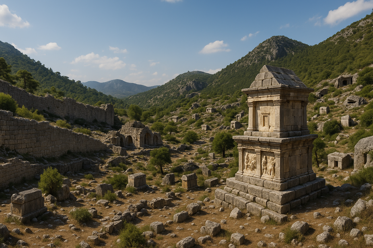
The Tomb of Alketas
On a cliff face west of the upper city, the Tomb of Alketas — that ill-fated Macedonian general — is cut directly into the rock. The relief above the entrance shows a mounted warrior, weapons and armour scattered at his feet. It is a rare survival of high-Hellenistic monumental sculpture, deeply weathered but still legible. The tomb is reached by a stiff scramble up the slope and is missed by most visitors.
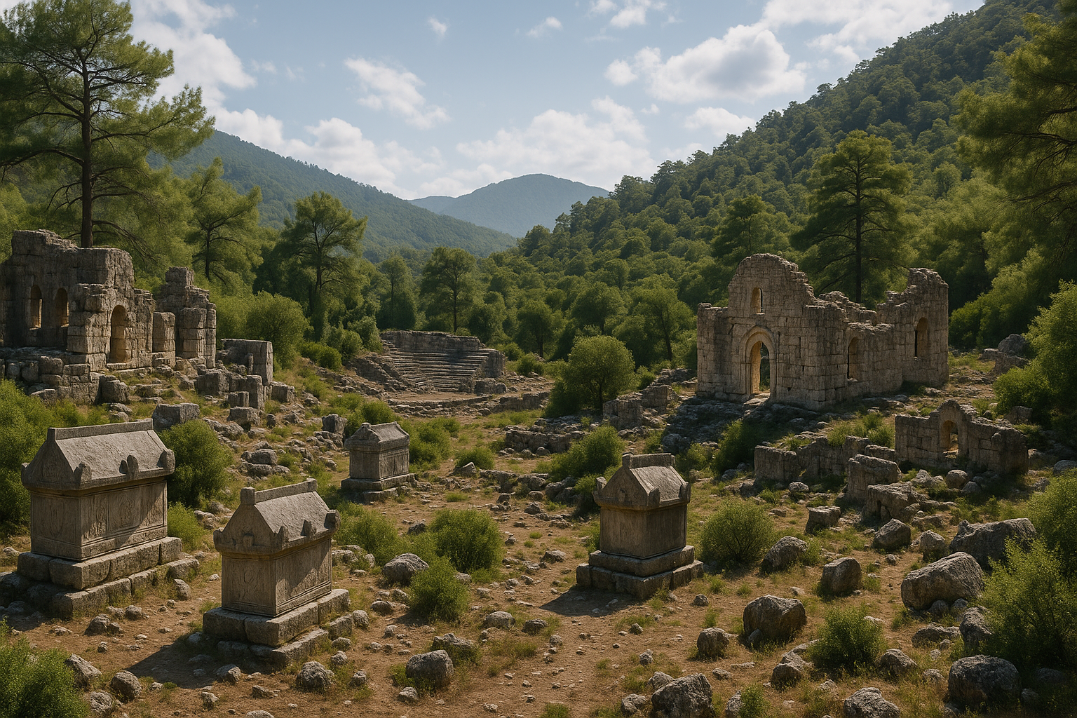
The Necropoleis
Termessos has not one cemetery but several, spread across the slopes outside the walls. The principal necropolis lies to the southeast along the King's Road; another extends west and north of the upper city, threading between the bouleuterion and the cliffs. Many sarcophagi carry inscriptions specifying the fines for unauthorised burial — typically 500 to 2,000 denarii to the city treasury, sometimes with a further sum to the temple of Zeus Solymeus. The names recorded across hundreds of tombs are a precious record of Pisidian onomastics.
"King's Tomb" monuments
A handful of free-standing tower-tombs and aedicula-tombs along the necropolis road are sometimes referred to as the King's Tombs. They are not royal — Termessos had no kings in the imperial period — but they are the funerary monuments of the city's wealthiest families, multi-storey and finely carved.
Stadium
A long, narrow flat shelf below the bouleuterion has been identified as the stadium. The retaining walls are partly visible. No seating survives. The flat ground would have accommodated athletic competitions during the city's regular games. Without excavation, the precise length and the configuration of the starting blocks cannot be confirmed.
Cisterns of the agora and the Heroon
Beneath the paving of the agora lies the largest of the city's water reservoirs, a deep rock-cut chamber with stepped descent and surviving hydraulic plaster. To one side of the agora stands a structure that has been variously interpreted as a heroon — a hero-shrine — or as the founders' monument of the city. The barrel-vaulted interior is partly intact. The dedication is unknown; without inscriptional evidence found in situ, the building's exact function cannot be settled.
The Corinthian temple
A small Corinthian temple, of late Hellenistic or early Roman date, stands on a podium near the upper edge of the inhabited area. Its dedication is uncertain. The proportions are elegant — a tetrastyle prostyle plan with a deep cella — and the surviving capitals show a refined late-Hellenistic Corinthian order. Local sculptors, working in the highland limestone, produced an architecture that holds its own against the marble temples of the coast.
Inscribed altars and statue bases
Throughout the public areas of the city, inscribed altars and statue bases survive in remarkable numbers. Many record dedications to the imperial cult, to the local gods, or to civic benefactors. Their texts are a major source for the chronology of the city's golden age, naming emperors from Augustus through the Severans and beyond. The corpus has been catalogued, with periodic updates, since the late nineteenth century.
Houses and the urban fabric
The domestic quarter has never been excavated, but the plan of the city is legible from the surface: terraced houses on the slopes, narrow streets stepped between them, courtyards opening onto cisterns. The masonry is the same dry-stone limestone as the walls. The form is recognisably Pisidian, austere and built for cold winters.
What can be read from the surface suggests a city of roughly 25 to 30 hectares within the inner wall, with an estimated population in the imperial period of perhaps 4,000 to 6,000 citizens, plus an unknown but probably substantial number of slaves, freedmen, and seasonal labourers. The street grid is irregular, conforming to the contours of the slope rather than to a Hippodamian plan. The principal arteries run east–west along the natural terrace, with stepped lanes climbing between them. The houses are of varied sizes; the larger ones cluster near the agora and the gymnasium, the smaller ones extend up to the outer wall. There is no obvious slum quarter, no rich enclave; the social geography of Termessos appears to have been more mixed than in many Roman cities.
The gymnasium and baths
A multi-room complex south of the agora has been identified as the gymnasium with attached baths, dated to the late Hellenistic and early Roman period. The plan covers approximately 45 × 25 m and includes an exercise yard, dressing rooms, a small caldarium and frigidarium, and a probable palaestra. The function is partly inferred from inscriptions found nearby that mention gymnasiarchs — magistrates responsible for the gymnasium. The walls survive to between two and four metres in places. As with everything else at Termessos, much of the plan must wait for excavation to be confirmed.
Alexander and Termessos
The story of Alexander at Termessos is told most fully by Arrian in Book I, chapters 27 and 28 of the Anabasis Alexandri. The passage deserves to be read in full, but the substance is this. After the storming of Sagalassos, Alexander turned south through Pisidia toward Pamphylia, intending to recover his army's coastal route. The road passed through a defile commanded by Termessos. The Termessians moved out and occupied the narrow ground.
Arrian writes that the Termessians "had already taken up a position on both sides of the road and on the heights commanding it, and the pass was difficult even without men in it." Alexander made a calculation. He could force the road, but only at great cost. He could lay siege to the city, but Termessos was set "on a sheer hill, like an eagle's nest" (so Arrian, or close to it), and any siege would consume the campaigning season. He chose neither. He drew up his army, made a show of intention, and when the Termessians withdrew at evening to the city, he marched past at night and continued his route. He never returned.
The episode appears also in Plutarch's Life of Alexander, in compressed form, and in later sources that derive from these two. Modern historians have debated the geographical detail — whether the famous defile is the Yenice gorge, as seems most likely, or a different pass entirely — but the essential point is uncontested. Termessos was the rare place where Alexander declined the engagement.
For the Termessians themselves this was a foundation myth as powerful as anything in Homer. Centuries later, the city's coins still showed the mountain, the god, the horse — the symbols of the unconquerable place. When Rome arrived, Termessos negotiated as a city that had never been beaten.
The Sagalassos comparison
Modern readers often ask: if Alexander could storm Sagalassos, why not Termessos? Both were Pisidian highland cities, both fiercely independent, both naturally defended. The answer lies in the specific topography. Sagalassos sat on a steep slope but was reachable by an army willing to climb. The Sagalassos campaign required a frontal assault uphill against entrenched defenders, but the ground was traversable. At Termessos, the only approach was a single defile commanded on both sides by garrisoned heights, with the city itself another 400 metres of vertical relief above. The defile could not be flanked. The heights could not be turned. The cost-benefit calculation that Alexander made daily across his Asian campaigns came out, here, on the side of leaving.
The Alexander historians
The major surviving accounts of Alexander's campaigns — Arrian, Plutarch, Diodorus Siculus, Curtius Rufus, Justin — vary in detail but agree on the substance of the Termessos episode. Arrian, drawing on Ptolemy's lost memoirs, is the most circumstantial. Diodorus omits the failed siege entirely, perhaps because it did not fit his narrative arc. Curtius Rufus mentions it in passing. The convergence of the sources on a single basic story — Alexander arrives, considers, withdraws — gives us confidence that the event is historical rather than a later embellishment of the Termessian self-image.
Modern military readings
Modern military historians have generally vindicated Alexander's decision. Donald Engels's Alexander the Great and the Logistics of the Macedonian Army (1978) emphasises that the Macedonian war machine depended on rapid movement and decisive battles; protracted sieges drained supplies, broke morale and gave time for enemies elsewhere to organise. Termessos, on its mountain, offered no decisive battle. To besiege it would have been to lose the war elsewhere. Alexander's instinct — to recognise the trap and decline it — is the mark of the strategist.
The Unexcavated City
Termessos is, in the most literal sense, an unexcavated city. This is a sentence that requires emphasis because it is so unusual. Every major ancient site in coastal Turkey — Ephesus, Pergamon, Aphrodisias, Hierapolis, Sagalassos, Perge, Side, Patara — has been the subject of decades of large-scale stratigraphic excavation, often by foreign academic missions in partnership with Turkish institutions. The results have transformed our understanding of Roman Asia Minor. Termessos has stood apart.
Why no excavation?
Several factors explain the situation.
- National park status. The site lies inside Güllük Dağı Millî Parkı, established in 1970. The protection regime that preserves the forest and wildlife also restricts archaeological intervention. Any excavation requires the agreement of the park authority as well as the Ministry of Culture and Tourism.
- Terrain. The site is steep, broken, partly cliff-bound, and accessible only on foot. The logistics of even a small trench — moving spoil, securing equipment, supplying water — are formidable.
- The forest itself. Excavation would mean cutting cedars, removing pines, and damaging the very ecosystem the park was created to protect. There has been a deep, principled reluctance to do this.
- The wealth of surface remains. Because so much survives above ground, the priority for generations of researchers has been survey and documentation, not digging. The result is one of the most thoroughly drawn ancient cities in the Mediterranean — and one of the least dug.
What we know nonetheless
The work that has been done is substantial. Charles Texier's drawings of the 1840s; Karol Lanckoroński's great Austrian expedition of the 1880s; the inscription corpus assembled and published over a century by Austrian and German epigraphers; conservation surveys by the Turkish authorities; and most recently a non-invasive surface and architectural survey by the Austrian Academy of Sciences in the 1990s — all these together give us a city in plan, in elevation, in epigraphic record. What we lack is stratigraphy.
The UNESCO Tentative List
Termessos was inscribed on Turkey's UNESCO World Heritage Tentative List in 2000. It has not yet been promoted to the full World Heritage List. The case for inscription — outstanding universal value as a Pisidian highland city of exceptional preservation — is strong. The work required to support a full nomination, however, includes a more thorough conservation plan and a more developed scholarly programme.
The potential of future research
If, one day, a programme of careful, targeted excavation is permitted, the questions are obvious: when was the upper city first occupied; what are the earliest cult deposits at the temple of Zeus Solymeus; what does the destruction layer in the cisterns look like; were the sarcophagi displaced by earthquake or by tomb-robbers; what coins, lamps, kitchen wares lie beneath the agora pavement. The answers, when they come, will reshape the history of Pisidia. Until then, Termessos remains the sleeping city.
A model already exists in Sagalassos, eighty kilometres to the north, where the Belgian-led excavations of the University of Leuven have, since 1990, transformed a comparable Pisidian hilltop city from an evocative ruin into one of the best-understood urban sites of the Roman East. Sagalassos shows what could be possible at Termessos: stratigraphic phasing of the agora, restoration of the major monuments, recovery of vast inscriptional and ceramic data, integration of the site with high-quality interpretive presentation for visitors. Whether Termessos will, or should, follow the same path is a question that will be answered in coming decades.
Remote sensing and digital documentation
Even without traditional excavation, modern techniques are beginning to read Termessos in new ways. Drone-based photogrammetry has produced high-resolution three-dimensional models of the major monuments. Lidar surveys, when permission can be secured to fly through the forest canopy, can reveal the buried plan of streets and buildings beneath the leaf-litter. Ground-penetrating radar, deployed in small targeted patches, can identify subsurface walls and voids. None of this substitutes for excavation, but together they are slowly extending the documentary record without disturbing the ground.
Mysteries of the Necropolis
The necropoleis of Termessos are among the most evocative funerary landscapes in the Mediterranean — not because they are tidy, but because they are not. The visitor who walks the King's Road outside the south gate, or climbs the slopes west of the upper city, walks among hundreds of broken sarcophagi, tilted, cracked, half-swallowed by leaf-litter, scattered across the mountain in apparent disorder.
The form of the cemetery
Termessian tombs take several forms:
- Free-standing limestone sarcophagi, often set on a podium, with gabled lids carved in imitation of roofs
- Rock-cut chamber tombs in the cliff faces, with carved doorways and sometimes interior benches
- Tower-tombs and temple-tombs for the wealthy
- Simple loculus graves for the poor
Many of the sarcophagi bear inscriptions in Greek recording the name of the deceased, the family relations, and the fine payable for any subsequent unauthorised burial — a feature so consistent that it amounts to a civic legal code.
The disorder
What strikes the visitor is the chaos. Lids have been thrown off. Sarcophagi lie tilted at angles of forty-five degrees. Massive limestone chests have been dragged or shifted yards from their podiums. The question is why.
Two explanations have been advanced.
-
Earthquakes. The 4th–5th century AD seismic sequence that broke the cisterns and damaged the temples would also have rocked the necropoleis. Many sarcophagi sit on raised plinths along steep slopes; even a moderate shock would topple them. The pattern of damage in places is consistent with a single catastrophic event.
-
Tomb-robbers. Late Antique and medieval grave-robbers, working for jewellery, metalwork and any valuable grave goods, would have prised off lids and broken into chambers. Some of the tombs show signs of deliberate breaching — clean breaks at hinge points, levering marks.
The truth is probably both, in sequence. An earthquake opened the cemetery; robbers finished the job. The forest grew back over the result.
A city of the dead
The Termessian cemeteries are larger in surface area than the inhabited city. They are also, in a sense, more public: every tomb is meant to be read, every name remembered. To walk among them is to walk through a population — perhaps eight or ten generations of Termessians at the city's peak — preserved in stone.
The fines for tomb violation
A characteristic feature of Termessian funerary inscriptions is the explicit specification of fines payable to the city treasury — and, in some cases, to the sanctuary of Zeus Solymeus — for any unauthorised disturbance of the tomb. The amounts vary from 500 to 2,000 denarii, with occasional much larger sums for the grandest monuments. The consistency of the formula across hundreds of inscriptions amounts to a public legal code. It tells us that the Termessians took the inviolability of burial extremely seriously, that the city government had the mechanisms to enforce such fines, and that the threat of fiscal punishment was considered the most effective deterrent against grave-robbery. The irony, of course, is that the system did not work; the tombs were robbed anyway, perhaps after the collapse of the civic government in the late fifth century.
Names and onomastics
The thousands of personal names recorded in the necropolis form an invaluable record of Pisidian onomastics. Alongside the Greek names introduced from the Hellenistic period onwards (Apollonios, Demetrios, Artemidoros), one encounters a substantial repertoire of native Pisidian names — Otanes, Trokondas, Kbedasis, Manes, Kendeas — that point to a continuing indigenous identity beneath the veneer of Greek cultural forms. Many tombs record a Greek given name followed by a Pisidian patronymic, or vice versa, suggesting a population comfortable with both linguistic worlds. By the late Roman period the Greek names dominate, but the Pisidian substratum never disappears entirely.
Women in the necropolis
A notable feature of the Termessian funerary record is the prominence of women. Inscriptions record female benefactors, priestesses, and tomb-commissioners. Several tombs were built by women, in their own names, for their own families. This is consistent with broader patterns in Pisidian society, where women appear to have enjoyed unusual public visibility compared with the Greek world. The cemeteries are not only a record of generations but a record of a society in which the agency of women left a durable mark in stone.
The Cistern System
There is no spring on the summit of Güllük Dağı. There is no stream within the walls of Termessos. Every drop of water that the city drank, washed in, and used in its baths and fountains had to be collected from rainfall and stored. The fact that a town of several thousand people sustained itself for centuries on a karst summit is a triumph of Pisidian hydrology.
The five large cisterns
The water system is built around five major cisterns in the upper city, each carved deep into the bedrock and lined with hydraulic plaster (opus signinum) to seal the porous limestone. Capacities have been estimated at tens of thousands of litres each. The largest of them, in the agora, is more than 10 m deep and has a stepped descent. The cisterns were fed by channelled runoff from the surrounding roofs, streets and natural rock surfaces, with settling basins to drop out sediment before the water entered the main reservoir.
Smaller cisterns
In addition to the five large reservoirs, dozens of smaller cisterns are scattered through the residential quarters. Many private houses had their own cistern beneath the courtyard. The total storage capacity of the city's water system would have been enough to carry the population through the dry summer between the autumn and spring rains.
Engineering features
Notable elements of the system include:
- Settling tanks upstream of the main cisterns to remove debris
- Stone covers (some still in place) to limit evaporation and contamination
- Overflow channels to direct excess water away during heavy storms
- Stepped access to allow drawing as water level fell
- Hydraulic plaster lining, much of which survives to this day
The system was destroyed, most likely, by the 4th–5th century earthquakes. Cracks in the rock-cut reservoirs allowed the stored water to drain. Without storage, the city could not survive a summer. The cisterns are, in this sense, the silent cause of Termessos's end.
A textbook of rainwater harvesting
For students of ancient engineering, the Termessian water system is a small textbook in itself. It demonstrates how a pre-industrial civilisation could sustain a substantial urban population in an environment with no surface water, using only catchment, storage, gravity and careful maintenance. The lessons are not just historical.
Estimating consumption
If we assume a Roman-period population of around 5,000 people consuming an average of 10 to 20 litres of water per person per day (a conservative figure that includes drinking, cooking, washing and a modest contribution to public fountains), the annual demand of Termessos was on the order of 18 to 36 million litres. A single major cistern might hold 5 to 10 million litres. The five large reservoirs together, supplemented by the residential cisterns, would have provided the necessary capacity, with seasonal recharge sufficient to bridge a typical Mediterranean dry summer.
The bath complex, with its hot pools and steam rooms, would have added significantly to demand. The fact that the bouleuterion is not far from one of the largest cisterns suggests a deliberate decision to locate the most water-intensive public functions near the points of storage.
Maintenance and management
Cisterns require constant maintenance. Sediment must be cleared, plaster relined, channels swept of debris. Inscriptions from comparable Pisidian cities mention specific magistrates — hydronomoi or "water-controllers" — responsible for the management of municipal water supplies. We can infer a similar office at Termessos. The smooth functioning of the system depended on these unsung administrators as much as on the original engineering.
What broke?
When the earthquakes came, what failed was the rock, not the engineering. Fissures opened in the bedrock floors of the cisterns. The hydraulic plaster cracked and could not be replaced fast enough. Water drained out. Without the cisterns, the city could not survive a summer. The earthquake did not destroy Termessos; it destroyed Termessos's ability to drink. The result was the same.
The Daily Life of a Termessian
What was it like to live in this city, eighteen hundred years ago? Without excavation, we can only sketch an outline, but the surface evidence supports a number of confident generalisations.
A working day
A wealthy Termessian of the second century AD would have woken in a stone-walled house terraced into the slope, with the cedar beams of the ceiling above and a small courtyard outside the door. Water was drawn from a private cistern beneath the courtyard. Breakfast was bread, olives, cheese and watered wine. The morning would be devoted to public business — meetings of the council, supervision of family commercial interests, visits to the agora. Lunch was the principal meal: bread, vegetables, perhaps fish brought up from the coast, more wine. Afternoons were given to the gymnasium and the baths, to social conversation, to dictation of letters, to the supervision of household and agricultural affairs. Evening brought another modest meal and, in season, the games or theatrical performances. The day ended early.
For a less wealthy citizen, the rhythm was different but the structure was the same. Artisans worked in their small shops along the streets that climbed away from the agora; market-gardeners tended terraces of vegetables and fruit on the slopes outside the walls; pastoralists drove their flocks up to the high meadows in summer and down again before the snows. The gymnasium was open to all male citizens; the baths similarly so. The theatre, when in use, was free at the point of entry, paid for by the wealthy benefactors whose names were inscribed on the seats they sponsored.
Food and agriculture
The territory of Termessos extended down the mountain and onto the foothills. Local production included wheat, barley, olives, grapes, figs, and a range of vegetables. The high pastures supported sheep, goats and cattle. Honey from the cedar forests was a notable export. Wine was made in the local valleys; oil pressing took place at lower altitudes. What could not be produced locally — fish, certain fruits, fine pottery, imported wines from Rhodes or Cilicia — was brought up from the coast. Donkey trains plied the road continuously through the campaigning season.
Family and household
Termessian inscriptions name extended families, often spanning four or five generations together. Patrilineal descent dominates, but matrilineal connections are frequently noted, and women appear as property-owners and tomb-commissioners in their own right. Slavery was present; manumission is recorded; the social distance between free and slave was real but not absolute. Children were named after grandparents; sons sometimes after fathers, with the addition of an epithet.
Death and remembrance
A Termessian who could afford one commissioned a tomb during his or her own lifetime, choosing the site, paying the carver, drafting the inscription. The fines for tomb violation were set in advance and inscribed on the chest. Family members were added in succession, sometimes with secondary inscriptions noting later burials. The tomb was a piece of public architecture, intended to be read by passersby for generations.
The frequency with which Termessian tombs include warnings to descendants, fines payable for unauthorised use, and threats against grave-robbers suggests an acute awareness of mortality and of the difficulty of securing the integrity of the grave across time. The dead, paradoxically, were among the most active participants in the civic life of the city. They had the longest memory.
Inscriptions and Civic Life
More than nine hundred Greek inscriptions have been recorded at Termessos, making it one of the most epigraphically rich sites in southern Anatolia. The corpus spans roughly seven centuries — from the late Hellenistic to the early Byzantine period — and ranges across every genre of public and private text.
Categories of inscription
- Funerary epitaphs: the largest group, dominating the necropoleis. Standard formulas record name, patronymic, family, and the fine for tomb violation.
- Honorific decrees: for benefactors of the city, military leaders, athletes, distinguished citizens. These texts are the principal source for the magistracies and offices of the civic government.
- Building dedications: recording the construction or restoration of temples, stoas, baths, the gymnasium. They name patrons, sometimes the architects, and the magistrates under whose supervision the work was done.
- Religious dedications: vows, thank-offerings, priestly inscriptions.
- Agonistic inscriptions: lists of victors in the city's games, recording the categories (running, wrestling, music, poetry) and the names of the winners.
- Boundary stones: marking the limits of the city's territory, sometimes referring to disputes with neighbouring communities.
The political vocabulary
The inscriptions reveal a city governed by the standard Hellenistic-Roman repertoire of magistracies: archons, prytaneis, agoranomoi (market-supervisors), gymnasiarchs, agonothetai. A council (boule) of perhaps several hundred members deliberated in the bouleuterion. An assembly of all citizens (demos) ratified its decisions. The formula "it was resolved by the council and the people of the Termessians" introduces hundreds of public decrees.
Language and identity
The inscriptions are almost exclusively in Greek by the imperial period, but the Pisidian onomastic substratum survives strongly. The vocabulary of magistracies is Greek; the names of the people who held those magistracies are often Pisidian. The bicultural character of the elite — Greek in education and public expression, Pisidian in family identity — runs as a continuous thread through the epigraphic record.
Publication history
The systematic publication of the Termessian inscriptions began with Heberdey's Termessos (1929) and has continued through the long series of volumes by Bülent İplikçioğlu and his collaborators in Epigraphische Forschungen in Termessos und seinem Territorium (Vienna, 1991–). New inscriptions are still being discovered through surface survey; the corpus continues to grow.
Comparisons with Other Pisidian Cities
Termessos was one of several major cities in highland Pisidia. A brief comparison places it in context.
Sagalassos
Eighty kilometres to the north, on the southern slopes of Akdağ at 1,500 m, Sagalassos is the great archaeological counterpart to Termessos. Where Termessos remains unexcavated, Sagalassos has been the subject of a major international excavation project led by the University of Leuven since 1990, producing one of the best-published Roman cities of Anatolia. Where Termessos refused Alexander, Sagalassos resisted and fell. The two cities together provide a comparative laboratory for the study of Pisidian urbanism — one excavated, one not; one stormed, one bypassed.
Selge
Further north and east, Selge sat on its own remote ridge above the Eurymedon canyon. Like Termessos, it preserved its autonomy and its self-image as an unconquered mountain city. The remains include a theatre, agora, stoa, and city walls, none of which have been systematically excavated. Selge's coinage shows close stylistic parallels with that of Termessos.
Cremna
To the northwest, Cremna was another fortified Pisidian city, partially excavated in the 1980s and 1990s. The site is famous for the dramatic Roman siege of the late third century, when the rebel Lydius held the city against imperial forces. Cremna's defensive engineering offers useful comparisons with Termessos's wall system.
Pednelissos
Closer to the coast, Pednelissos was a smaller Pisidian community involved in territorial disputes with both Selge and Termessos. Inscriptions from each city record their conflicts and reconciliations.
The Pisidian network
Together these cities formed a network of highland communities, united by language, religion, military culture, and a fierce regard for local independence. They competed and quarrelled but recognised one another as kin. Termessos was the southernmost major node in this network, and the closest to the coastal world of Pamphylia.
Modern Conservation Challenges
The preservation of Termessos in something like its ancient form is a remarkable achievement, but it is not effortless. Several persistent threats require ongoing management.
Forest fires
The combination of dry summers, dense pine and cedar forest, and visitor activity creates a chronic fire risk. A major fire in the park, however unlikely, could devastate both the ecosystem and the soft surfaces of the ruins. Park authorities maintain fire lookouts, water tankers, and access roads for emergency response. Visitors are reminded that all open flame, including cigarette smoking, is forbidden in the archaeological zone.
Earthquakes
The seismic vulnerability of the masonry continues. The walls that survived the 4th-5th century earthquakes are not necessarily proof against future events. Conservation interventions over the past several decades have included the discreet pinning of loose blocks, the stabilisation of leaning walls, and the documentation of structures most at risk.
Vegetation damage
Tree roots in masonry are the slow enemy of every ancient site in a forested setting. At Termessos, conservators face a dilemma: removing the trees that grow through walls would damage the masonry as much as leaving them would. The current policy is selective intervention, removing the most damaging trees while preserving the integrity of the forest landscape.
Visitor pressure
The number of visitors to Termessos remains modest by comparison with coastal sites — perhaps tens of thousands per year, against millions at Ephesus — but is rising as more travellers seek out lesser-known destinations. The footpaths, the sarcophagi, and the masonry are all subject to wear. Park authorities have begun marking certain paths and discouraging shortcuts, but enforcement on a site this large is difficult.
Vandalism and theft
Inscribed blocks are occasionally damaged by graffiti. Small portable objects, where they have been found on the surface, have sometimes been removed. The site is regularly patrolled, but its size makes comprehensive monitoring impossible. Visitors are asked to report any damage they observe.
Coinage and Economy
Termessos minted its own bronze coinage from the third century BC onwards, and continued to do so under Roman rule through the third century AD. The coins are an important historical source in their own right, and their imagery encodes the city's self-understanding.
Civic types
The standard reverse types include:
- Zeus Solymeus seated, holding sceptre and eagle — the city's principal deity
- A galloping horse, often with a Greek letter above, marking the year of issue
- Artemis standing with bow
- The cult statue of Zeus within a tetrastyle temple facade
- The Greek legend TEP or TEPMHCCEΩN (of the Termessians) framing the design
The obverse typically shows the laureate head of Zeus, or in imperial times the bust of the reigning emperor with appropriate titles.
Economic life
The city's economy rested on a familiar set of highland resources: timber from the cedar and pine forests; pastoralism in the high meadows; grain from the small valleys; honey, wax, and pitch; quarried limestone for export to lowland building sites. Wine and olive oil were imported from the coast, paid for in part by the export of mountain produce. The coinage facilitated this regional exchange. The fact that Termessian coins are found across Pisidia and Pamphylia, but rarely beyond, gives a sense of the geographic range of the city's commerce.
The horse and the rider
The horse appears more frequently on Termessian coins than on any other Pisidian civic coinage. The animal had a specific local importance: the warrior-rider on the relief above the Alketas tomb is one expression of the same theme. Termessos prided itself on the quality of its cavalry. Whether the warrior-on-horseback was understood as a hero, a god, or simply as the ideal of the citizen-soldier, the image runs as a continuous thread through the city's visual culture from the Hellenistic period to the late empire.
Numbers and Measurements
| Item | Value |
|---|---|
| Elevation of city centre | ~1,050 m above sea level |
| Summit of Güllük Dağı (Solymos) | 1,665 m |
| Distance from Antalya | 30 km (northwest) |
| Climbing road from park gate to upper parking | ~9 km |
| Walking path from parking to ruins | ~1 km, ascending |
| Theatre seating capacity | ~4,000–4,200 |
| Theatre cavea diameter | ~58 m |
| Bouleuterion / Odeon internal plan | ~24 × 18 m |
| Bouleuterion capacity | ~600 |
| Temple of Zeus Solymeus, cella wall height surviving | ~5 m |
| Upper Agora, open court | ~40 × 30 m |
| Major cisterns | 5 |
| Approximate number of catalogued tombs | 1,200+ |
| Recorded Greek inscriptions | 900+ |
| Independent civic coinage from | 243 BC |
| Date of Alexander's failed approach | 333 BC |
| Tentative UNESCO inscription | 2000 |
| Güllük Dağı National Park established | 1970 |
| Area of national park | ~6,702 hectares |
Practical Realities and Limitations
Any honest visitor guide to Termessos must acknowledge a few practical realities that the romance of the place can obscure.
It is harder than it looks
The walk from the parking area to the upper city is not long in distance but is sustained in gradient. Visitors in modest physical condition will arrive at the agora tired and short of breath. The terrain inside the ruins compounds this: there are no level paths, no graded surfaces, no escalators or shuttle services. Plan for the effort.
The interpretive infrastructure is minimal
There are signs at the major monuments, in Turkish and English, but they are sparse and sometimes weathered. The site has no audio guide, no app, no guided tour service operating regularly. Visitors who arrive without preparation will miss much of what they walk past. Reading a few pages in advance — including, for example, this very guide — multiplies the value of the visit.
Services are limited
There is no restaurant in the ruins, no shop selling water beyond the visitor centre at the lower parking, and no medical facility on the mountain. Bring everything you need.
Weather can be a hazard
Summer heat is real even at altitude. Winter storms can be sudden and unpleasant. Rain makes the stones slippery. Plan accordingly and turn back if conditions change.
Snakes and other wildlife
The mountain is home to several snake species, including the Mediterranean viper, which is venomous though shy. Keep to paths, watch where you put your hands and feet on warm stones, and do not attempt to handle any snake you encounter. Wild boar are present but rarely seen during daylight. The risks are low but real.
The site rewards thought, not haste
A rushed visit to Termessos misses the point. The site does not have a single great monument that can be photographed and ticked off. It has, instead, a sustained atmosphere that emerges only across a few hours of attentive walking. Visitors who treat it as a quick stop between Antalya and Olympos will leave disappointed. Visitors who give it half a day or more will carry it with them.
The Soundscape of Termessos
One feature of Termessos that no photograph can capture is its sound. The city sits high enough above the road and far enough into the forest that the human noise of the modern world is largely absent. What remains is a complex natural soundscape worth attending to during a visit.
The cedars
A wind through cedar branches is unlike a wind through pine. The needles are shorter, denser, and produce a softer, more rustling sound than the higher hiss of pine. In the upper city, where the cedar stands are concentrated, the air carries this characteristic cedar-rustle. It is the same sound the Termessians would have heard.
The birds
The mountain holds a rich resident bird population, supplemented in spring and autumn by migrants moving along the Mediterranean flyway. Common heard species include the chukar partridge (its distinctive cackle), various warblers, the song thrush, and the great spotted woodpecker. The cliffs are home to crag martins and alpine swifts whose calls echo against the rock. Eagles, when they pass overhead, make no sound; their presence is announced by the silence of every other bird in the immediate vicinity.
The acoustics of the ruins
The architecture itself shapes the acoustic experience. The bouleuterion, with its four standing walls, creates an audible reverberation that responds to a footstep, a clapped hand, or a quiet voice. The theatre, even in its ruined state, gathers and projects sound in its characteristic way; a single word spoken in the orchestra reaches the upper rows clearly. The narrow defile of the gorge below the theatre amplifies and carries sounds upward, so that occasional voices from the road or the parking area below can be heard with surprising clarity.
Silence
But the dominant impression of Termessos is silence. The kind of silence that has texture — the small adjustments of leaves and stone and wind that fill a quiet place and that the modern visitor, accustomed to constant ambient noise, rarely encounters. To sit in the upper rows of the theatre on a still morning and listen to this silence is one of the unexpected gifts of the visit.
A Note on Names
The names attached to Termessos and its mountain deserve a brief explanation. Several layers of nomenclature overlap.
Termessos / Termessus
The Greek name Termessos (Τερμησσός) is attested from the Hellenistic period onwards. The Latin form Termessus appears in Roman administrative texts. The etymology is uncertain; the most plausible derivation traces the name to a pre-Greek Anatolian root meaning approximately "end" or "boundary" — a reference, perhaps, to the city's position at the southern limit of Pisidia where the highlands give way to the Pamphylian plain.
The Solymoi / Solymi
The people of the mountain are called Solymoi (Σόλυμοι) in Greek sources, Solymi in Latin. Homer's Iliad names them in this form. The same root gives the mountain its ancient Greek name, Solymos (Σόλυμος), and the city's chief deity, Zeus Solymeus (Ζεὺς Σολυμεύς).
The Solymoi are sometimes connected by ancient and modern speculation to the Hebrew name "Salem" (associated with Jerusalem) and to the legendary association of southern Anatolia with eastern Mediterranean migrations. The linguistic connection is speculative and uncertain.
Güllük Dağı
The modern Turkish name of the mountain is Güllük Dağı — "the rose-place mountain" or "the mountain of roses," after the wild flowers that cover its meadows in spring. The name appears in Ottoman administrative records and seems to have replaced the older classical names sometime in the medieval period. There is no surviving folk memory of the name "Solymos" in the local communities.
Modern usage
In modern English-language scholarship, the city is uniformly called Termessos. The mountain is sometimes called Mount Solymos (in classical contexts) or Güllük Dağı (in modern contexts). The national park is called either Güllük Dağı National Park or Termessos National Park; the official Turkish name is Güllük Dağı–Termessos Millî Parkı. All of these refer to the same place.
The Park and the Site Today
The relationship between the archaeological ruins and the surrounding national park is one of the defining features of a visit to Termessos. It is worth understanding the framework within which the site is managed.
Establishment of the park
Güllük Dağı Millî Parkı (Güllük Dağı National Park) was established in 1970 by the Turkish government as a protected natural and archaeological area covering approximately 6,702 hectares. The boundaries enclose not only the immediate vicinity of the ancient city but a substantial portion of the surrounding mountain landscape, including forests, meadows, cliffs and a portion of the Antalya–Korkuteli road corridor.
The legal basis is dual: protection of the natural environment (under the relevant national parks legislation) and protection of the archaeological heritage (under the Law for the Protection of Cultural and Natural Heritage, currently Law No. 2863 of 1983). Both regimes operate simultaneously, and any activity within the park requires the agreement of both the General Directorate of Nature Conservation and the relevant cultural heritage authorities.
Daily management
The park is staffed by rangers responsible for visitor safety, environmental protection, and basic site maintenance. A small visitor centre near the parking area provides interpretive information, basic maps, and (in season) a café service. Toilets are available at the visitor centre.
The path through the ruins is maintained but not paved beyond a certain elevation. Signage is present but variable in quality. Multilingual interpretation is limited; most signs are in Turkish and English, with occasional German and French.
Special considerations
- Fire prevention is a major operational focus, particularly in summer. No open flames are permitted in the archaeological zone.
- Wildlife disturbance is minimised by limiting visitor access to marked paths.
- Scientific research is welcomed but requires permits from the Ministry of Culture and Tourism.
- Filming and photography for commercial purposes requires advance arrangement.
- Drones are prohibited within the park without specific permission.
The future of the park
Discussions about the future of Güllük Dağı and Termessos involve several stakeholders: the central government in Ankara, the provincial authorities in Antalya, the local communities of the surrounding villages, and the international archaeological community. Proposals have included a possible expansion of the protected area, the development of interpretive infrastructure, the launch of a systematic excavation programme, and the eventual nomination of the site for full UNESCO World Heritage status.
The pace of change has been deliberately slow, reflecting both the difficulty of the terrain and a genuine principled commitment to preserving the site's distinctive atmosphere. Whether that balance can be maintained as visitor numbers grow is one of the open questions of the next generation.
Architecture and Building Techniques
The masonry of Termessos is one of its quiet glories. The technique is consistent across the major monuments and represents a distinct Pisidian architectural tradition that deserves examination.
The dry-stone technique
Termessian walls are built of large, carefully fitted limestone blocks laid without mortar. The technique is sometimes loosely called "Cyclopean" — though the blocks at Termessos are not as enormous as those at Mycenae or Tiryns — or "polygonal" or "dry-stone." The fitting of the blocks is precise: faces are dressed to the line of the wall; joints are tight enough to exclude a knife blade; the overall surface is smooth where it needs to be (in temples and gates) and roughly textured where it does not (in plain stretches of city wall).
The advantages of mortarless construction are several. The wall can flex during seismic events, with individual blocks rocking against each other rather than failing as a rigid unit. Maintenance is straightforward: a displaced block can be reseated without breaking adjacent masonry. Erosion is slow because there is no soft mortar joint to wash out.
Battered walls
The city walls and many of the larger buildings are battered — that is, their outer face inclines slightly inward as the wall rises. The batter increases stability by lowering the centre of gravity, and it resists undermining by tools or by water erosion at the base. The technique is common in fortification architecture across the Mediterranean and Near East, but the Termessian version is particularly clean and consistent.
Block dimensions
Standard blocks in the major Termessian walls measure roughly 0.6 to 1.2 metres in length, 0.4 to 0.6 metres in height, and 0.5 to 0.8 metres in depth. Larger blocks (up to 2 metres long) are used at corners and at points of structural stress. The quarrying must have been local; limestone outcrops within the city itself show evidence of ancient cutting.
Tools and labour
Iron chisels, mallets, levers, pulleys, and timber sledges would have been the principal tools. The workforce was probably a mix of free citizens (for skilled tasks), slaves (for unskilled labour), and contracted specialists (for the most precise work). The construction of a major building — a temple, the bouleuterion — would have occupied a team of perhaps several dozen workers for several years.
The Roman additions
Roman-period construction at Termessos uses largely the same techniques as the Hellenistic phases, with two notable additions. Mortared rubble cores appear in some walls, faced with the traditional dressed ashlar. Brick and tile appear in certain late constructions, particularly bath buildings and vaults. The Roman work integrates with the Hellenistic without disruption; the city's architectural tradition was continuous.
Decoration
The decorative repertoire of Termessian architecture is restrained by comparison with the coastal cities. Marble was not locally available and had to be imported at considerable expense. Most surfaces are dressed limestone, sometimes plastered and painted but rarely faced with marble. The temples and the Hadrian's Gate are exceptions, with finer decorative carving in the Corinthian and composite orders. The overall character is austere, monumental, and deeply suited to the highland setting.
Termessos in Literature
Beyond Arrian's account of Alexander's withdrawal, Termessos appears intermittently in classical literature. The references are scattered but suggestive.
Homer and the Solymoi
The reference in Book VI of the Iliad, in which Bellerophon fights the Solymoi as the second of his three impossible tasks, is the deepest layer in the literary tradition about the people of Mount Solymos. Homer's text is brief — a single line specifies that the Solymoi were "the most warlike men I have ever encountered" — but the resonance is enormous. For the Termessians of the classical and Hellenistic periods, Homeric authority confirmed their ancient identity and martial reputation. Coins, inscriptions, and literary references throughout antiquity return to the Solymoi as a foundational identification.
Strabo
The geographer Strabo, writing in the early first century AD, places Termessos in his survey of southern Asia Minor (Geography 14.3.9). He describes the city as situated on a narrow pass between mountains and notes its tradition of independence. His information is second-hand, drawn from earlier geographers and Roman administrative records, but he correctly identifies the topographic essentials.
Plutarch
Plutarch's Life of Alexander mentions the Termessos episode in compressed form, in keeping with the biographical genre's focus on character rather than military detail. The mention confirms that the story of Alexander's withdrawal was part of the standard Alexander tradition by the second century AD.
Arrian
Arrian's Anabasis Alexandri I.27-28 remains the principal source. Arrian, working from the lost memoirs of Ptolemy and Aristobulus, gives the most detailed account of the geographical and military situation. His description of Termessos as "set on a sheer hill, like an eagle's nest" became the defining image of the city in later tradition.
Diodorus Siculus
Diodorus Siculus in the eighteenth book of his Library of History records the Hellenistic episode of Alketas and the Termessians. The narrative is partial — Diodorus is selective in his focus — but provides the essential information about the city's role in the wars of the Diadochi.
Stephanus of Byzantium
The sixth-century AD geographical lexicon of Stephanus of Byzantium includes an entry on Termessos, noting its location and its identification with the Solymoi. The entry is brief but confirms that the city's name remained known in late antiquity even after its physical abandonment.
Christian sources
The acta of various ecumenical councils name the bishops of Termessos through the fourth and fifth centuries. These references are administrative rather than literary, but they extend the historical record of the city into the period of its decline.
Modern literature
In the modern period, Termessos appears in the travel literature of nineteenth-century European explorers (Texier, Spratt, Forbes), in the great folio of Lanckoroński (1890-92), and in the scholarly publications of the Austrian and German archaeological institutes through the twentieth century. The British travel writer Freya Stark visited in the 1950s and described the site, in Alexander's Path, as "one of the loveliest and loneliest places in Anatolia." George Bean's Turkey's Southern Shore (1968) brought Termessos to a wider English-language readership.
The Theatre in Detail
The theatre at Termessos deserves a closer look. It is the single feature of the site that brings most visitors here in the first place, and it rewards extended attention.
Construction history
The theatre was first built in the Hellenistic period, probably in the third or second century BC, when Termessos was a fully autonomous Pisidian polis. The original form would have followed the standard Greek theatre plan: a horseshoe cavea cut into the slope, a circular orchestra, and a simple stage building of stone or timber. The Hellenistic phase is most clearly preserved in the lower seating, which is cut directly into the bedrock.
A major Roman expansion in the second century AD added the upper seating, the elaborate stone scaenae frons, and the parodos vaults. The stage building was monumentalised with engaged columns, niches and statuary. The capacity was increased to its final figure of roughly four thousand. The Roman work survives in the lower courses of the stage building and in many of the upper seats.
Architectural features
- Diameter of the cavea: approximately 58 metres
- Number of seating rows: 26
- Divisions: the cavea is divided horizontally by a diazoma (walkway) at mid-height, and vertically into wedge-shaped sections (kerkides) by radial stairways
- Vomitoria: vaulted passages allowing spectators to enter and leave the seating without disrupting the seated audience
- Parodoi: the two side entrances to the orchestra, partly vaulted and surviving in fragmentary form
- Stage building: rectangular in plan, with three doorways onto the stage and a second story above. The decoration would have included statues in niches between the columns of the scaenae frons
The view
From the upper rows, the view extends south down a deep forested gorge to the Pamphylian plain and the Gulf of Antalya. On the clearest winter days, the snow-capped peaks of the Beydağları range can be seen to the southwest. The theatre is positioned, deliberately, so that the audience watching a performance had this view as the backdrop. The stage building, when intact, would have partially obstructed it; but anyone climbing to the upper rows during an interval would have been confronted by the chasm and the sea.
Acoustics
The theatre's acoustics are excellent, even now. A speaker in the orchestra can be heard clearly in the upper rows. Modern visitors regularly test this by clapping or speaking from the orchestra; the response is striking. The combination of the precise geometric design of the cavea, the natural rock backing, and the partly enclosed space created by the surrounding cliffs creates a sound chamber of unusual quality.
Performances
What was performed here? Greek tragedy and comedy, probably; mime and pantomime, certainly, by the Roman period; civic assemblies; religious processions; athletic events. Inscriptions from Termessos mention the Termessia, the city's regular athletic and musical festival, and we may assume the theatre was a principal venue. The mountain gods would have been honoured here, and the emperors of Rome would have received their due acclamations.
The condition today
The theatre survives in remarkable condition considering its age, its exposure, and the absence of any major conservation programme. Several rows of seating are intact and continuous. The stage building has collapsed but its foundations and lower walls remain. The parodos vaults survive partially. Earthquakes have displaced some blocks; tree roots have lifted others; but the overall form is unmistakable.
A Visitor's Walk Through the City
For the reader planning a visit, what follows is a suggested route through the principal monuments, ordered as the modern visitor encounters them.
From the parking area to Hadrian's Gate
The path begins at the parking area and climbs through pine and cedar forest for about a kilometre. The first significant ruin to come into view is the lower city wall, with its dry-stone ashlar masonry running between rock outcrops. The path passes through a gateway in this wall and emerges into a sloping clearing scattered with fallen blocks. Hadrian's Gate stands a short distance ahead, its surviving columns and entablature framing the approach. Pause here. Look back the way you have come; this is the line of approach Alexander would have seen.
Through the King's Road to the upper city
From Hadrian's Gate, the path follows the line of the ancient King's Road upward and to the left. The defensive walls rise on either hand. The first cisterns are visible to the right of the path, their dark mouths now choked with leaves. Watch the masonry of the walls — note the slight inward batter at the base, the absence of mortar, the precision of the joints.
The agora
After about ten minutes' walk from the gate, the path opens into the agora, a paved limestone terrace cut from the slope and surrounded on three sides by the foundations of stoas. Stand in the centre of the square. To the north, on a higher terrace, are the temples of Zeus Solymeus and Artemis. To the east is the bouleuterion. To the south, the ground falls steeply away toward the theatre. Beneath your feet, somewhere under the paving, lies the great cistern.
The bouleuterion
A few steps east of the agora stands the bouleuterion, the city council chamber, with its four walls intact to the cornice. Step inside. The acoustics, even now without a roof, are uncanny. Speak quietly to a companion across the chamber. The Termessian council met here for centuries.
The temples
Climb the steps to the temple of Zeus Solymeus. The cella walls rise to five metres; the porch and stairs are partly intact. Picture the cult statue in the interior shadow, the smoke of sacrifice rising from the altar before the steps. Then move west to the smaller foundation of the temple of Artemis, much more reduced but identifiable by its altar bases.
The theatre
From the agora, a path descends and curves southward to the theatre. The cavea opens suddenly, dropping away in front of you. Walk down to the orchestra. Look up at the ranked seats, then turn and look out through the gap of the stage building at the chasm beyond. The Mediterranean is visible on the horizon. Climb to the upper rows for the full view. Sit here for a while. This is the moment Termessos gives that no other site in Anatolia can give.
To the Alketas tomb
The route to the Alketas tomb branches off to the west of the main circuit. Look for the signpost at the bouleuterion. The path climbs steeply for about fifteen minutes through forest, ending at the foot of a cliff. The tomb is cut into the rock face at head height. The relief of the mounted warrior is above the doorway; weapons are scattered beneath his horse. Take time to read what survives.
The necropolis
To complete the visit, leave the upper city by the south gate and follow the King's Road downward. The path passes through the principal necropolis, where hundreds of sarcophagi lie scattered through the pines. Many bear inscriptions; with patience, individual names can be deciphered. Walk slowly. There is no hurry. The dead have nowhere to go.
Back to the parking area
The return path retraces much of the route in. Allow an hour for the walk down with stops. By late afternoon the light through the cedars is golden and the silence is complete.
Religion and Cult
The religious life of Termessos was shaped by its mountain. Zeus Solymeus — Zeus assimilated to a local mountain god — was the dominant deity, and his cult ran from at least the Hellenistic period through the late Roman empire. The temple of Zeus Solymeus stood in the civic centre; his image appeared on the city's coins; his sanctuary was the recipient of tomb-violation fines.
Alongside Zeus, the city honoured Artemis, whose temple stood behind the odeon, and a range of other Olympian deities (Hermes, Apollo, Athena) attested through inscriptions and altars. The imperial cult — the worship of the reigning emperor and the deified emperors of the past — was organised through dedicated priests and probably housed in or near the agora.
The Solymos myth
The mountain god Solymos appears in several Hellenistic and Roman literary sources as the eponymous ancestor of the Solymoi. Some accounts make him a son of Zeus and the local nymph Chaldene; others connect him to the Lycian Sarpedon. The Termessians themselves seem to have understood Solymos and Zeus as essentially the same god — the mountain itself, divinised. The cult formula Zeus Solymeus (Zeus-of-Solymos) captures this synthesis.
Cult practice
Without excavation, the details of cult practice at Termessos are inferred from inscriptions and from comparisons with better-known Pisidian sites. Animal sacrifice, processions, public banquets, athletic and musical festivals (the Termessia) — the standard repertoire of Greek civic religion adapted to the local context. The bouleuterion may have been used for the meetings of religious associations as well as the city council. The theatre would have hosted ritual performances as well as secular drama. The boundary between civic and religious life, as everywhere in the ancient Mediterranean, was indistinct.
The Christian transition
The transition to Christianity in the fourth and fifth centuries appears, on present evidence, to have been gradual rather than violent. The Pagan temples were not, as far as we can tell, deliberately destroyed; they were allowed to fall into disuse and were eventually quarried for spolia. A bishopric was established. Whether there was active resistance from the older religious establishment is unknown. The mountain god, in any case, was sleeping by then.
Visitor Information
Getting there
Termessos lies about 30 km northwest of Antalya on the Antalya–Korkuteli road (D650). The signposted national park entrance is on the right (north) side of the road when driving from Antalya. From the park gate, a winding tarmac road climbs roughly 9 km through the cedar and pine forest to a small parking area below the ruins. There is no public bus to the park gate; visitors normally come by rental car, taxi or organised tour. The closest serviced bus stop is at the Korkuteli highway junction, from which a taxi must be arranged for the final climb.
From the parking area, a stone-paved path climbs for about 1 km through the King's Gate and into the lower city. Allow 20–30 minutes for this approach walk. There is no road into the ruins themselves.
Hours and tickets
The site is part of Güllük Dağı–Termessos National Park and is administered jointly by the General Directorate of Nature Conservation and the Ministry of Culture and Tourism.
- Summer hours (April–October): roughly 08:00 to 19:00
- Winter hours (November–March): roughly 08:30 to 17:00
- Tickets: a single national park entry fee covers access to the ruins. The MuseumPass Antalya is accepted at the gate.
- Hours and fees can change without notice. Verify before you go.
Time needed
- Quick visit (theatre, agora, gate): 2 hours minimum
- Standard visit (all main monuments, partial necropolis): 3–4 hours
- Full visit (Alketas tomb, far necropoleis, summit views): half a day or more
The site is large and the terrain is steep. Pace accordingly.
Best season
- Spring (April to early June): ideal. Wildflowers, cool air, long days
- Autumn (mid-September to early November): also excellent. Clear light, fewer visitors
- Summer (June–August): hot, but consistently 5–8 °C cooler than central Antalya thanks to altitude and shade. Start at opening
- Winter (December–February): the upper road may be closed after snow. Verify with the park authority before driving up
What to bring
- Sturdy walking shoes — lightweight trekking boots are ideal. Sandals are a mistake.
- At least 1.5 to 2 litres of water per person. There is no drinking water in the ruins.
- Sun hat and sunscreen. The upper rows of the theatre are unshaded.
- A jacket or fleece outside summer. Wind on the summit can be sharp.
- Camera — the light at sunset in the theatre is among the finest in southern Turkey.
- A snack — there is no café in the ruins.
- Snake awareness. Mediterranean vipers are present, though shy. Watch where you put your hands and feet, particularly on warm rocks.
Hazards
The site borders steep cliffs, particularly along the south side of the theatre and around the necropolis paths above the gorge. There are no railings. Children must be supervised closely. After rain, the limestone paving becomes slippery. The footing inside the ruins is uneven; rocks, roots, and displaced blocks are the rule, not the exception.
Accessibility
The site is, frankly, not accessible to visitors with significant mobility impairments. The approach involves a 1 km climb on a stepped stone path, and movement inside the ruins requires walking on uneven, often steep terrain with no rails or graded surfaces. Visitors with reduced mobility may wish to view the lower section near the King's Gate and forgo the upper city.
Nearby sites and combinations
Termessos is naturally combined with:
- Antalya Archaeological Museum — for the statuary and sarcophagi removed from the regional necropoleis. A perfect afternoon counterpart to a morning at the ruins.
- Karain Cave — Palaeolithic site, 27 km southeast of Termessos.
- Phaselis — coastal Lycian-Pamphylian harbour city, about 60 km southwest of Antalya. A different climate, a different mood, but a comparable atmosphere of ruin-in-pine.
- Olympos and Chimaera — Lycian site with the eternal flame, 90 km southwest.
- Central Antalya (Kaleiçi) — the Roman-Ottoman harbour quarter, for an evening after the mountain.
A reasonable day plan from Antalya: leave early, drive 45 minutes to the park, spend the morning on the mountain, come down for lunch, visit the Antalya Museum in the afternoon, sit in Kaleiçi at dusk. You will have seen the best of Pisidia and Pamphylia in twelve hours.
Photography notes
- Theatre at sunrise: the eastern light catches the back wall of the scaenae and the cliffs behind the cavea. Soft, golden, and the gorge below is still in shadow.
- Theatre at midday: harsh, contrasty, and crowded. Avoid if possible.
- Theatre at sunset: the Gulf of Antalya catches the gold light and the upper cavea is warm. Best wide-angle moment of the day.
- Bouleuterion in mid-morning: the south wall catches direct sun while the interior remains shadowed. The famous "skeleton" view of the four-walled chamber works best now.
- Necropolis in late afternoon: the low light catches the relief carving on the sarcophagi and the texture of the broken stone. The photographic strength of the cemetery is in the disorder, not the individual tombs.
- Hadrian's Gate: photograph from inside looking out at the approach path, with the gate framing the cliffs beyond.
A polarising filter is useful for the long vistas. A wide lens (24 mm equivalent or wider) is necessary for the architectural interiors. Tripods are permitted but rarely necessary; the light is generally good enough for handheld work.
Where to stay
There is no accommodation inside the park. The standard options are:
- Central Antalya (Kaleiçi): boutique hotels in the Ottoman harbour quarter; about 45 minutes' drive from the park gate
- Konyaaltı or Lara beach hotels: standard resort accommodation, also about 45 minutes
- Korkuteli town: a small market town 30 km north of the park, with modest hotels; useful if combining Termessos with Sagalassos or other northern Pisidian sites
- Wild camping: not permitted at the ruins, but there are designated areas in the wider park; check with the park authority
Food and water in the park
There is no restaurant at the upper parking area or in the ruins. A small café operated near the visitor centre during high season, but its opening hours are unpredictable. Bring your own food and water. Take all rubbish back down the mountain.
Frequently Asked Questions
Was Termessos really never conquered?
In the strict sense, yes. No army is recorded to have taken the city by force. Alexander did not besiege it. The Hellenistic kingdoms did not subdue it. Rome did not conquer it — Termessos negotiated its alliance and kept its autonomy. The city's end came from earthquake, not enemy.
How accurate is Arrian's account of Alexander's withdrawal?
Arrian is one of the most reliable of the surviving Alexander historians, working from the lost memoirs of Ptolemy and Aristobulus. His description of the topography at Termessos is consistent with the actual ground. Modern military historians have generally accepted that Alexander's decision was rational: the defile could not be forced cheaply, and a siege of the upper city was impossible without water and timber.
Has Termessos really never been excavated?
Not in the systematic, stratigraphic sense that has been applied to almost every other major ancient site in Turkey. Surface survey, architectural drawing, epigraphic recording, conservation interventions and limited cleaning have all been done. A research excavation reaching pre-Roman levels has not.
Who were the Solymoi?
The Solymoi were a Pisidian people, kin to the Lycians and Pamphylians, mountain-dwellers of southwestern Anatolia. Homer names them in the Iliad as the warriors against whom Bellerophon was sent. They worshipped Zeus Solymeus — a Hellenised version of an older mountain god — and built their principal city at Termessos.
What language did the Termessians speak?
Pisidian, an Anatolian language related to Luwian, in earlier centuries. By the Hellenistic period most public inscriptions are in Greek, and Pisidian was probably dying out. A handful of late Pisidian inscriptions survive, mostly funerary.
Why is the necropolis so disordered?
Because the tombs were shaken by earthquake in the late Roman period and then opened by grave-robbers in Late Antiquity and the Middle Ages. The displacement is real, ancient, and visible.
Where exactly is the Tomb of Alketas?
On the cliff face west of the upper city, accessed by a steep path that branches off the main route. Look for signs at the bouleuterion. The relief of the mounted warrior, much weathered, is high on the rock above the doorway.
Is there shade at the theatre?
Some. The cavea is partly shaded by trees in the morning and by the cliff itself in the late afternoon. Midday sun on the upper rows is intense.
Are dogs allowed?
The national park permits dogs on leash on the access roads. Inside the archaeological site, policy varies; check at the gate. Dogs are not recommended in any case because of the wildlife and the snake risk.
Can I camp inside the park?
Not at the ruins. Designated camping areas exist elsewhere in the national park. Wild camping in the archaeological zone is forbidden.
Is the site illuminated at night?
No. The site closes at sunset. There is no electric lighting in the ruins.
Is Termessos on the UNESCO World Heritage List?
It is on Turkey's Tentative List, added in 2000, but has not yet been inscribed as a full World Heritage Site. The case for inscription is strong.
How long should I plan for a visit?
A minimum of three hours from arrival at the park gate to departure: thirty minutes to drive up, twenty minutes to walk in, ninety minutes inside the ruins, twenty minutes to walk back. A more rewarding visit takes four to five hours. A full half-day or longer allows you to reach the more distant tombs and to sit quietly in the theatre.
Is there a guide service?
Independent licensed guides operate out of central Antalya and will accompany visitors to Termessos by prior arrangement. There is no on-site guide service at the park gate. For a first visit, a guide adds significantly to the experience by pointing out features (the Alketas tomb, the cisterns, the King's Road) that an unaccompanied visitor might miss.
What about the weather?
The mountain has its own micro-climate. Summer can be hot in direct sun but pleasant in the shade. Spring and autumn can bring rapid weather changes — bright sun one hour, cold rain the next. In winter, the upper road can be impassable after snow or ice. Always check forecasts. Always carry a layer.
Can I see Termessos from below?
Yes. The cliffs of Güllük Dağı are visible from the Antalya-Korkuteli road, and on a clear day the position of the upper city can be picked out against the skyline. But the ruins themselves are only visible from within the park.
What is the most overlooked monument?
The Alketas tomb, almost certainly. It requires a stiff scramble up a side path west of the main route, and many visitors do not realise it is there. The relief of the mounted warrior, even in its weathered state, is one of the most evocative pieces of Hellenistic funerary art in Anatolia. Give it half an hour. It deserves it.
Will future excavations change what we know?
Almost certainly, when they happen. The questions raised by surface survey — about the date of the earliest occupation, the relationship between the Pisidian and Greek phases of the city, the cause and sequence of the late Roman collapse — can only be answered by stratigraphic excavation. The day Termessos is opened to systematic digging will be a significant day in Anatolian archaeology.
Sources and Further Reading
- Termessos — Wikipedia
- Antalya İl Kültür ve Turizm Müdürlüğü — Termessos — Antalya Provincial Directorate of Culture and Tourism, official site information
- Güllük Dağı–Termessos National Park — Turkish Ministry of Agriculture and Forestry, General Directorate of Nature Conservation
- Antalya Archaeological Museum — for the Termessian sarcophagi and statuary
- UNESCO World Heritage Tentative Lists — Termessos — Turkey's tentative submission, 2000
- Termessos — Turkish Archaeological News
- Arrian, Anabasis Alexandri, Book I, chapters 26–28. Translated by P. A. Brunt, Loeb Classical Library, Harvard University Press
- Plutarch, Life of Alexander, chapters 18–19
- Lanckoroński, K. Städte Pamphyliens und Pisidiens, vol. II: Pisidien. Vienna, 1892. Digital scans available through the Heidelberg University Library and the Internet Archive
- Texier, C. Description de l'Asie Mineure. Paris, 1839–1849
- Heberdey, R. Termessische Studien. Vienna: Hölder-Pichler-Tempsky, 1929
- Iplikçioğlu, B. Epigraphische Forschungen in Termessos und seinem Territorium. Vienna: Austrian Academy of Sciences, various volumes, 1991–
- Mitchell, S. Anatolia: Land, Men, and Gods in Asia Minor. Oxford: Clarendon Press, 1993
- Çelgin, A. V. Termessos ve Çevresinde Epigrafya Araştırmaları. Istanbul, 1994
- Bean, G. E. Turkey's Southern Shore. London: Ernest Benn, 1968 — still the most readable English-language introduction to the Pisidian and Pamphylian sites
- Stark, F. Alexander's Path. London: John Murray, 1958 — the British travel writer's account of following the route of Alexander's campaign through southern Anatolia, including Termessos
- Engels, D. Alexander the Great and the Logistics of the Macedonian Army. Berkeley: University of California Press, 1978 — for the strategic context of Alexander's decision at Termessos
- Mansel, A. M. Die Ruinen von Side. Berlin: De Gruyter, 1963 — the standard study of Side, useful for comparing the development of Pamphylian and Pisidian cities
- Waelkens, M. and Loots, L. (eds). Sagalassos: Report on the Survey and Excavation Campaigns. Multiple volumes, Leuven University Press, 1993– — the great comparative source for excavated Pisidian urbanism
- Strabo, Geography, Book 14, chapter 3
- Stephanus of Byzantium, Ethnika, entry on Termessos
- Horsley, G. H. R. The Greek and Latin Inscriptions in the Burdur Archaeological Museum. London: British Institute at Ankara, 2007 — context for the inscriptional culture of highland Pisidia
Final Reflections
Termessos asks something of the visitor that most ancient sites do not. It is not arranged for the casual tourist. It does not offer easy answers. The interpretive signs are sparse; the paths are stony; the relevant scholarship is in German and Turkish and is not always translated. To get the most out of the visit, the traveller must come prepared — read a little in advance, bring proper shoes, allow proper time, and be willing to climb.
What is given in return is rare. Most ancient cities in the Mediterranean have been excavated, restored, paved, signposted, and curated within an inch of their lives. The visitor experience, in such places, is highly mediated. Termessos has been left, very nearly, as it was found. The dialogue is direct: traveller and stone, with as little between them as eighteen centuries of forest growth and silence permits.
This is also why Termessos rewards return visits. Each season the light is different. Each year the carpet of wildflowers shifts in pattern. The same fallen sarcophagus reads differently in March mist than in September gold. The same theatre, in the silence of a winter morning, becomes another building than the one filled with summer voices.
For the scholar, Termessos is an open question — many open questions — awaiting the day when systematic excavation may finally be permitted. For the traveller, it is one of the great experiences of southern Turkey, and one of the few places in the Mediterranean where the ancient world can still be encountered, at full scale, in something close to the form in which the ancients themselves left it.
Termessos rewards the patient visitor. It does not give itself up in a single passage through the theatre and the agora. Walk slowly. Sit in the upper rows and listen. Climb to the Alketas tomb. Lose the path among the sarcophagi. The mountain has been keeping its silence for sixteen centuries; it will not be broken in a hurry.