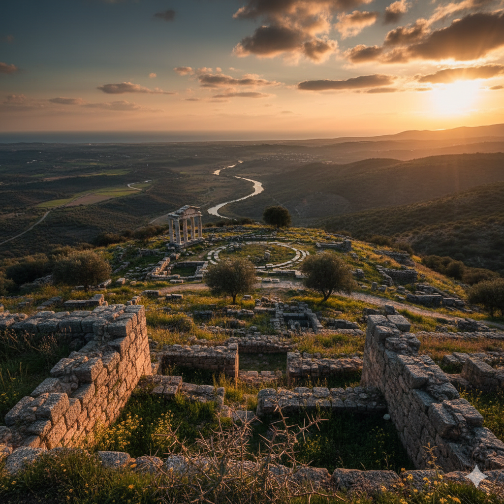
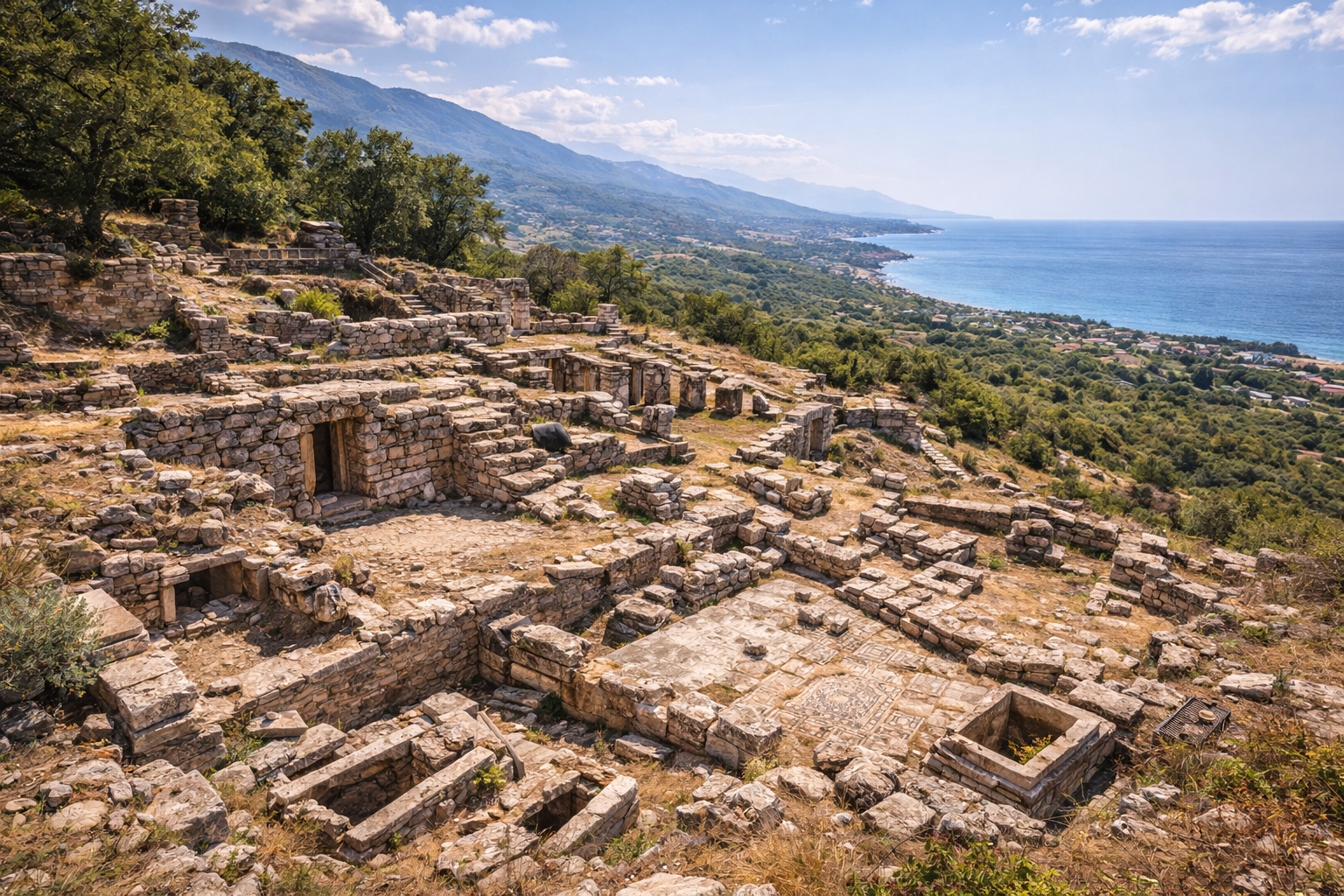
Alexandria Troas is one of the largest ancient cities in Anatolia, located near Dalyan village in the Ezine district of Canakkale Province, on Turkey's northwestern Aegean coast. Founded around 310 BC by Alexander the Great's general Antigonus I Monophthalmus, the city covered approximately 400 hectares (1,000 acres) and was enclosed by walls stretching nearly 10 km in circuit. At its height during the Roman Imperial period, Alexandria Troas served as the chief port of northwestern Asia Minor, with an estimated population of up to 100,000 inhabitants. The site preserves monumental remains including the massive Herodes Atticus Bath-Gymnasium (one of the largest in the Roman world, measuring 123 x 84 meters), a theater seating up to 12,000 spectators, a stadium, an odeon, a twin-basin harbor, and an extensive aqueduct system sourced from Mount Ida. Alexandria Troas also holds biblical significance as a port visited by the Apostle Paul on his missionary journeys, where he received the famous "Macedonian vision" that led Christianity into Europe.
- Why Alexandria Troas Matters
- Geography and Setting
- Historical Timeline
- Major Monuments
- Biblical Connection
- Archaeological Work
- Visitor Information
- Frequently Asked Questions
- Sources and Further Reading
Why Alexandria Troas Matters
-
One of Anatolia's largest ancient cities: With approximately 400 hectares enclosed by nearly 10 km of walls, Alexandria Troas was among the biggest cities in ancient Asia Minor, comparable in size to cities like Ephesus. Both Julius Caesar and Emperor Constantine reportedly considered it as a potential capital of the Roman Empire before ultimately choosing Rome and Constantinople respectively. This consideration alone illustrates the city's perceived strategic importance.
-
Principal port of the region: The city's excellent twin-basin harbor on the Aegean coast, at the maritime approach to the Dardanelles, made it the main embarkation and disembarkation point for ships traveling between Roman Europe and Asia. Vessels waited here for favorable winds before entering the strait, making it one of the busiest transit points in the eastern Mediterranean.
-
Monumental Roman architecture: The Herodes Atticus Bath-Gymnasium complex, funded by one of the richest men in the ancient world around 135 AD, measures 123 by 84 meters -- making it one of the largest Roman bath buildings ever discovered. It was supplied by an aqueduct bringing water from Mount Ida (Kaz Dagi) over a distance of approximately 30 km.
-
Synoecism and urban planning: The city was created through a dramatic act of synoecism -- the forced merger of populations from surrounding Troad cities including Neandria, Larisa, Hamaxitus, and Kolonai. This makes Alexandria Troas a prime example of Hellenistic "planned city" creation, where existing communities were consolidated into a single new urban center.
-
Biblical significance: Alexandria Troas appears in the New Testament (Acts 16:8-11, Acts 20:5-12, 2 Corinthians 2:12). The Apostle Paul visited the city multiple times, and it was here that Paul had his famous "Macedonian vision" -- the dream calling him to cross into Europe, a moment considered pivotal in the spread of Christianity from Asia to Europe.
-
A 2,200-year-old market discovered in 2025: Ongoing excavations continue to reveal new structures, including a Hellenistic-period market uncovered in early 2025, demonstrating that the vast majority of this enormous city remains unexplored beneath the surface.
Geography and Setting
Alexandria Troas occupies a coastal plain on the Aegean shore, approximately 20 km south of Ezine and 30 km south of the Apollo Smintheus Temple at Gulpinar. The site faces the island of Bozcaada (ancient Tenedos) across a narrow channel.
Key geographic features:
- Harbor: The city possessed a twin-basin harbor -- an outer basin open to the sea and an inner protected basin. The harbors are now largely silted up, but the mole walls and basin outlines remain visible. The harbor's position provided shelter from prevailing northerly winds, making it ideal for ships waiting to enter the Dardanelles.
- Coastal plain: Unlike the hilltop cities of the Troad (Troy, Assos, Neandria), Alexandria Troas was deliberately built on low-lying coastal terrain to maximize harbor access and urban expansion space. This was a conscious strategic choice reflecting Hellenistic urban planning priorities.
- Mount Ida water supply: An aqueduct system approximately 30 km long brought fresh water from the springs of Kaz Dagi (Mount Ida) -- the same mountain sacred in Trojan War mythology as the seat of Zeus during the conflict. The aqueduct employed both open channels and arched bridge sections to traverse the terrain.
- Defensive walls: The 10 km wall circuit enclosed a vast area, much of which was not densely built. This suggests the walls were designed for future expansion as much as for defense, reflecting ambitious expectations for the city's growth.
- Geological setting: The area sits on granitic bedrock, which provided durable building stone. The golden-hued granite gives the surviving ruins their characteristic warm color, particularly the Bath-Gymnasium known locally as "Bal Saray" (Honey Palace).
- Modern access: Reachable from Ezine (approximately 20 km) via a road passing through or near Dalyan village. The site is signposted from the main Ezine-Ayvacik road.
The broader Troad region is one of the most historically significant landscapes in the ancient world, containing Troy (Hisarlik), Assos, Neandria, the Apollo Smintheus sanctuary at Chryse, and numerous other Bronze Age and Classical sites within a compact area.
Historical Timeline
Foundation as Antigonia Troas (c. 310 BC)
Around 310 BC, Antigonus I Monophthalmus (Antigonus the One-Eyed), one of the most powerful Diadochi (successors of Alexander the Great), founded a new city on the Aegean coast of the Troad. He named it Antigonia Troas and populated it through synoecism -- the forced relocation of populations from surrounding smaller cities including:
- Neandria (the mountain fortress on Cigri Dag)
- Hamaxitus (the settlement near the Apollo Smintheus sanctuary)
- Larisa
- Kolonai
- Other small communities of the southwestern Troad
The site was chosen for its excellent natural harbor and its position on the major sea route between the Aegean and the Dardanelles. The forced consolidation of multiple populations into a single new city was a characteristically Hellenistic strategy for creating instantly powerful urban centers.
Renaming to Alexandria Troas (301 BC)
After Antigonus was defeated and killed at the Battle of Ipsus in 301 BC, the Thracian king Lysimachus took control of the city and renamed it Alexandria Troas in honor of Alexander the Great, whose name carried immense prestige and legitimacy throughout the Hellenistic world. The renaming also served to erase the memory of Lysimachus's defeated rival.
Hellenistic Period (301--133 BC)
During the Hellenistic era, Alexandria Troas quickly grew into the dominant city of the Troad region. It became a free and autonomous city as early as 188 BC following the Treaty of Apamea, which reorganized Roman influence in Asia Minor after the defeat of the Seleucid king Antiochus III. The city established its own civic institutions, began minting coins bearing its name, and developed its harbor infrastructure into the region's premier port facility.
Roman Colony under Augustus (30 BC -- 14 AD)
Under Emperor Augustus, Alexandria Troas received the prestigious status of a Roman colony -- officially titled "Colonia Alexandria Augusta Troas", commonly shortened to simply "Troas." As a colony, the city's inhabitants received Roman citizenship, and the city was granted tax-exempt status (ius Italicum). Veterans of Roman legions were settled here, bringing Roman cultural practices, Latin language, and architectural traditions. The colonial status made Alexandria Troas one of the most privileged cities in the province of Asia.
Peak Prosperity: Hadrian and Herodes Atticus (117--180 AD)
The city reached its zenith during the 2nd century AD. When Emperor Hadrian visited (during his reign, 117--138 AD), construction activities intensified. The wealthiest private individual in the Roman world, the Athenian Herodes Atticus, financed the construction of the massive bath-gymnasium complex around 135 AD, along with an aqueduct bringing water from Mount Ida. This period saw the city's population reach an estimated 100,000 people, making it one of the largest cities in the Roman province of Asia.
Late Roman and Byzantine Decline (3rd--7th century AD)
Like many Roman cities, Alexandria Troas experienced gradual decline from the 3rd century onward due to economic contraction, barbarian raids, and shifting trade routes. However, it remained an important port and episcopal seat into the Byzantine period. A bishopric was established here, and the city continued to function as a harbor town, though at a fraction of its former scale.
Ottoman Period and Quarrying
After final abandonment, the site was extensively quarried for building stone. Columns, blocks, and architectural elements from Alexandria Troas were shipped to Istanbul (Constantinople) and used in major Ottoman construction projects, including mosques such as the Suleymaniye and public buildings. This systematic stone removal over centuries significantly reduced the visible remains, meaning what survives today represents only a fraction of the original built environment.
Major Monuments
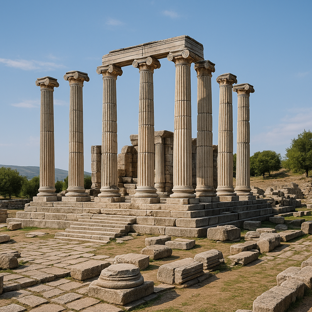
Herodes Atticus Bath-Gymnasium (Bal Saray)
The signature structure of Alexandria Troas and one of the most impressive Roman buildings in Turkey:
- Dimensions: 123 x 84 meters -- among the largest Roman bath complexes ever discovered anywhere in the empire
- Patron: Herodes Atticus (101--177 AD), an Athenian aristocrat, Roman senator, and one of the wealthiest individuals in the ancient world. He was known for financing public buildings across Greece and the Roman East, including the famous Odeon in Athens.
- Date: Constructed around 135 AD during or shortly after Emperor Hadrian's visit
- Local name: Known locally as "Bal Saray" (Honey Palace) due to the golden color of the granite in certain light
- Features: The complex included the standard Roman bath sequence (frigidarium, tepidarium, caldarium), a gymnasium for exercise, and large assembly halls. The walls still stand to a height of several meters in places, with visible vault springings, window openings, and traces of marble revetment.
- Water supply: Fed by an aqueduct approximately 30 km long, sourced from springs on Mount Ida (Kaz Dagi). Remains of the aqueduct arches are visible in the landscape between the mountain and the city.
- Current state: The walls of the bath complex are among the most visually dramatic Roman ruins in the Troad. Despite Ottoman-era quarrying that removed much decorative stonework, substantial structural sections survive and convey the enormous scale of the original building.
Theater
Located on the western edge of the city:
- Capacity: Estimated at up to 12,000 spectators, making it one of the largest theaters in the Troad
- Date: Hellenistic foundation (approximately 2,400 years old), expanded and modified in the Roman period
- Discovery: The theater was identified during recent excavation campaigns, confirming the presence of a major performance venue befitting a city of this size
- Current state: Partially excavated; the cavea (seating area) is visible but overgrown in parts. Ongoing work continues to reveal its full dimensions.
Stadium
One of the few identified stadiums in the ancient Troad:
- Used for athletic competitions and public festivals
- Located within the city walls
- Partially visible in the landscape, with further details emerging through ongoing excavation
Odeon
A small covered theater for musical performances and council meetings:
- Located near the center of the city
- Roman period construction, reflecting the full range of civic amenities expected in a major colonial city
Twin-Basin Harbor
The economic heart of the city:
- Outer basin: Open to the sea, used for ship approach and anchorage while waiting for favorable winds
- Inner basin: Protected by mole walls, used for loading, unloading, and ship repair
- Quay walls: Stretching approximately 600 meters in total length
- Current state: Largely silted up over centuries, but basin outlines and mole walls are still traceable. The harbor area is partially flooded and surrounded by wetland.
City Walls
The massive defensive circuit:
- Length: Approximately 10 km
- Enclosed area: Approximately 400 hectares
- Construction: Primarily Hellenistic, with Roman-era repairs and additions
- Features: Multiple gates, towers, and curtain walls. Sections are well-preserved, particularly on the southern and eastern sides, where walls stand to impressive heights.
Aqueduct
The water supply system from Mount Ida:
- Length: Approximately 30 km
- Patron: Herodes Atticus (2nd century AD)
- Features: Stone and brick arched sections spanning valleys and watercourses. Several aqueduct arches survive in the countryside between the city and Mount Ida, creating atmospheric landmarks in the rural landscape.
Dodecagonal Structure (discovered 2024)
A 1,850-year-old dodecagonal (12-sided) building dating to the reign of Emperor Hadrian (mid-2nd century AD). During 2024, the structure was virtually reconstructed using augmented reality technology and shared with approximately 1,200 visitors. Its function is still under investigation but may have been a nymphaeum (monumental fountain) or a temple. This represents one of the most innovative applications of digital technology at a Turkish archaeological site.
Hellenistic Market (discovered 2025)
Excavations in early 2025 revealed a 2,200-year-old market structure from the Hellenistic period, providing new evidence of the city's commercial infrastructure during its earliest centuries. This discovery underscores how much of Alexandria Troas remains buried and awaiting investigation.
Biblical Connection
Alexandria Troas holds an important place in Christian history and is mentioned multiple times in the New Testament:
- Acts 16:8-11: Paul and his companions traveled through Mysia and came to Troas. Here, Paul had his famous "Macedonian vision" -- a dream in which a man from Macedonia begged him, "Come over to Macedonia and help us." This vision prompted Paul to cross from Asia into Europe, a moment considered a turning point in the history of Christianity. The crossing was made by ship from Troas's harbor to Neapolis (modern Kavala), beginning the evangelization of Europe.
- Acts 20:5-12: Paul visited Troas on his return journey. During a long sermon at a third-story window, a young man named Eutychus fell asleep, fell from the window, and was thought dead, but Paul revived him. This vivid narrative provides one of the most detailed descriptions of early Christian worship in the New Testament.
- 2 Corinthians 2:12: Paul writes of coming to Troas to preach the gospel and finding an open door there, indicating a receptive community for Christian teaching.
- 2 Timothy 4:13: Paul asks Timothy to bring his cloak and scrolls, which he left at Troas with Carpus, suggesting Paul maintained personal connections in the city.
For Christian pilgrims and biblical history enthusiasts, Alexandria Troas is a significant site that connects the journeys of Paul with the physical landscape of the ancient Roman world. The harbor from which Paul sailed to Europe can still be traced in the silted-up basin.
Archaeological Work
Early Modern Travelers (17th--19th century)
European travelers documented the impressive ruins from the 17th century onward. The "Bal Saray" (Herodes Atticus Bath) was a particular landmark noted by nearly every visitor to the Troad, including Charles Texier in the 1830s and Karl Graf Lanckoronski in 1885. Many early visitors initially confused Alexandria Troas with Troy itself, given the scale of the ruins.
Ottoman Quarrying
Systematic removal of building stone for Istanbul construction projects significantly reduced the visible remains during the Ottoman period. Columns from Alexandria Troas were used in major mosques and palace complexes. This destruction of ancient fabric for reuse is documented in Ottoman administrative records.
Modern Excavations: Erhan Oztepe and Ankara University (2000s--present)
Systematic excavations have been conducted under the direction of Prof. Dr. Erhan Oztepe from Ankara University, with a team of approximately 30 researchers. The project has received funding through the Ministry of Culture and Tourism's "Legacy to the Future" (Gelecek Mirasi) initiative. Key achievements include:
- Excavation and documentation of the Herodes Atticus Bath complex, revealing its full plan and construction techniques
- Investigation of the harbor area and identification of the twin-basin system
- Uncovering a 2,000-year-old altar in the sanctuary area
- Discovery of the 1,850-year-old dodecagonal building in 2024, subsequently made explorable via augmented reality for approximately 1,200 visitors
- Discovery of a 2,200-year-old Hellenistic market in January 2025
- Identification and initial excavation of the 2,400-year-old theater with an estimated 12,000-spectator capacity
- Documentation of the stadium and odeon
- Mapping of the complete city wall circuit using both traditional survey and geophysical methods
- Study of the aqueduct system from Mount Ida
The site has also been the subject of geophysical surveys (magnetometry, ground-penetrating radar) that have revealed the extent of unexcavated structures beneath the surface, demonstrating that the vast majority of Alexandria Troas remains underground and awaiting future investigation.
Visitor Information
Getting There
- From Ezine: Approximately 20 km south, about 25 minutes by car via Dalyan village
- From Canakkale: Approximately 55 km, about 1 hour by car
- From Apollo Smintheus Temple (Gulpinar): Approximately 20 km north, about 25 minutes
- From Troy (Hisarlik): Approximately 50 km south, about 1 hour
- From Istanbul: Approximately 350 km, about 4.5 hours by car or via Canakkale ferry
The site is signposted from the Ezine-Ayvacik road.
Hours and Admission
- Open daily. Hours typically 08:30--19:00 in summer, 08:30--17:00 in winter.
- Check the Turkish Museums website or Ministry of Culture and Tourism for current conditions and any seasonal adjustments.
- Museum Pass Turkiye is accepted.
Time Required
- Minimum: 1.5--2 hours (bath complex, harbor area, and wall sections)
- Recommended: 3--4 hours (comprehensive exploration including theater, stadium, and wall circuit)
- Full day: Combine with Apollo Smintheus Temple (20 km) and/or Neandria (9 km) for a complete Troad experience
Best Seasons
- Spring (April--May): Ideal -- wildflowers, mild weather, manageable walking conditions
- Autumn (September--October): Excellent temperatures, good light for photography
- Summer: Very hot; the site offers minimal shade. Start early morning and bring ample water.
- Winter: Quiet and atmospheric; some paths may be muddy. The harbor area can be partially flooded.
Practical Tips
- Wear sturdy walking shoes. The site is enormous (400 hectares) and much of it is unexcavated terrain with tall grass, fallen stones, and uneven ground.
- Bring plenty of water (at least 2 liters per person) and sun protection, especially in summer.
- The Herodes Atticus Bath ("Bal Saray") is the most accessible and dramatic structure -- make it a priority.
- The harbor area is interesting but can be marshy; approach carefully, especially after rain.
- A detailed guidebook or map is very helpful given the site's vast size. Without guidance, many structures are difficult to identify among the vegetation.
- The site is much less visited than Troy, offering a quieter, more exploratory experience.
- For the augmented reality experience of the dodecagonal building, check if a mobile app or on-site technology is currently available.
- Combine your visit with the beautiful Aegean coastline and the nearby island of Bozcaada for a memorable day trip.
Frequently Asked Questions
Why is Alexandria Troas so large but relatively unknown?
Despite being one of the biggest ancient cities in Turkey, Alexandria Troas has received less archaeological attention and tourist development than sites like Ephesus or Troy. Ottoman-era quarrying removed many above-ground remains, and the site's vast size makes comprehensive excavation extremely challenging and expensive. However, what survives -- especially the Herodes Atticus Bath -- is monumentally impressive, and ongoing excavations are steadily revealing more of the city.
Was this city really considered as a Roman capital?
Ancient sources indicate that both Julius Caesar and Emperor Constantine considered Alexandria Troas as a potential location for an imperial capital, due to its strategic harbor position between Europe and Asia. Constantine ultimately chose Byzantium (Constantinople/Istanbul), but the consideration illustrates the city's perceived importance as a crossroads between continents.
What is the connection to the Apostle Paul?
Paul visited Alexandria Troas multiple times on his missionary journeys. Most significantly, it was here that he received the "Macedonian vision" (Acts 16:9-10), which led him to cross into Europe and begin evangelizing Greece -- a pivotal moment in Christian history. Paul sailed from the harbor of Troas to Neapolis (modern Kavala), carrying Christianity across the Aegean for the first time.
Who was Herodes Atticus?
Herodes Atticus (101--177 AD) was an Athenian aristocrat, philosopher, and Roman senator who was one of the wealthiest individuals in the entire Roman Empire. He was famous for financing grand public buildings, including the Odeon of Herodes Atticus below the Acropolis in Athens. At Alexandria Troas, he funded the massive bath-gymnasium complex and its aqueduct around 135 AD, creating one of the largest bathing facilities in the Roman world.
How does this site compare to Ephesus?
In terms of original size, Alexandria Troas was comparable to Ephesus. However, Ephesus has been extensively excavated and restored for tourism, while Alexandria Troas remains largely unexcavated. Visitors to Alexandria Troas experience a raw, atmospheric archaeological landscape rather than a restored museum-city. For those who enjoy the romance of discovery and exploration, Alexandria Troas offers a more adventurous experience.
Can I see the aqueduct?
Yes. Remains of the aqueduct arches are visible in the countryside between the city and Mount Ida, particularly along the road south of Ezine. They are not formally marked as a tourist site but are visible from the road and create atmospheric landmarks in the rural landscape.
What was discovered in 2025?
Excavations in January 2025 revealed a 2,200-year-old Hellenistic-period market structure, providing new evidence of the city's commercial infrastructure during its earliest centuries. This discovery adds to the growing understanding of Alexandria Troas as a major commercial center from its very foundation.
What happened to the populations of the cities destroyed by synoecism?
The populations of Neandria, Hamaxitus, Larisa, Kolonai, and other small Troad communities were forcibly relocated to populate the new city. This was a common Hellenistic practice -- by concentrating scattered populations into a single large city, rulers could create an instantly powerful urban center with sufficient population to defend itself, generate tax revenue, and serve as a regional capital. The abandoned cities gradually fell into ruin; Neandria's mountaintop fortress on Cigri Dag can still be visited today.
Is Alexandria Troas suitable for visitors with limited mobility?
The Herodes Atticus Bath complex is the most accessible monument, reachable via relatively flat paths from the parking area. However, much of the site involves walking over uneven terrain with tall grass, and the acropolis and harbor area require more physical effort. The site is not fully adapted for wheelchair access.
What is the "Bal Saray" legend?
The local name "Bal Saray" (Honey Palace) comes from the golden-warm color the granite walls take on in certain light conditions, particularly at sunset. Some local traditions also associate the name with a legend about honey being stored in the great building, though this is folk etymology rather than historical fact.
What is the dodecagonal building?
The dodecagonal (12-sided) building is one of Alexandria Troas's most enigmatic structures. Its unusual shape has puzzled scholars, with theories ranging from a nymphaeum (monumental fountain) to an imperial cult building. Recent restoration work in 2024 included the addition of augmented reality (AR) content allowing visitors to visualize the original appearance of the structure using their smartphones. The building's unique geometry makes it virtually unparalleled in Roman architecture.
What granite was used in the city's construction?
Alexandria Troas was built with locally quarried grey granite from nearby sources in the Troad region. This granite was prized across the ancient world -- columns and building materials from Alexandria Troas were exported as far as Constantinople, where they were reused in the construction of Hagia Sophia and other major buildings. Ottoman builders also quarried the site extensively for construction projects in Istanbul.
How big was the ancient harbor?
The harbor of Alexandria Troas was one of the largest on the eastern Aegean coast. Archaeological surveys have identified a closed harbor basin approximately 100,000 square meters in area, protected by massive breakwaters. The harbor gradually silted up during late antiquity, contributing to the city's decline. Today the ancient harbor basin is marshy lowland, but its outline remains detectable from satellite imagery and ground survey.
What other ancient sites are nearby?
Several significant ancient sites lie within easy driving distance: Troy (Hisarlik) is approximately 30 km to the north; Assos (Behramkale) with its Temple of Athena is about 50 km south along the coast; the ancient fortress of Neandria on Cigri Dag is roughly 20 km east. A visit to Alexandria Troas combines well with a broader tour of the Troad region's remarkable density of ancient sites.
When is the best time to visit?
Spring (April-May) and autumn (September-October) are ideal. The site is largely open and unshaded, making summer visits extremely hot. In spring, wildflowers cover the site and the surrounding countryside is green. Winter visits are possible but the ground may be muddy after rain, and some areas may be waterlogged near the harbor basin.
What was the city's water supply system?
Alexandria Troas had a sophisticated water supply. Beyond the famous Herodes Atticus aqueduct from Mount Ida, the city also had underground cisterns and a network of ceramic pipes. The aqueduct ran approximately 30 km from sources on the slopes of Kaz Dagi (Mount Ida) to the city, using a combination of open channels, closed conduits, and bridges. Its engineering represents one of the most ambitious water infrastructure projects in Roman Asia Minor.
Did the city have a theater?
Yes. In 2024, archaeologists announced the discovery of a 2,400-year-old Greek theater at the site, predating the Roman period. This theater dates to the Hellenistic era, making it one of the earliest monumental structures in the city. Its discovery was significant because previous surveys had not identified a theater, and major Roman cities without theaters are extremely rare. Further excavation is expected to reveal more of its structure.
What role did the city play in the Crusades?
During the medieval period, Alexandria Troas's harbor was used as a staging point by some Crusader expeditions heading to the Holy Land. The city's position on the route between Constantinople and the Levant made it a natural stopping point. However, by this period the city was already largely in decline, and the harbor facilities were diminished compared to their Roman-era capacity.
Architectural Measurements and Structural Data
The monumental scale of Alexandria Troas has been documented through systematic excavation and geophysical survey. The following tables compile verified dimensional data from published reports.
Herodes Atticus Bath-Gymnasium -- Detailed Dimensions
| Element | Measurement | Notes |
|---|---|---|
| Overall plan dimensions | 123 x 84 m | Among the largest Roman bath complexes in the entire empire |
| Patron | Herodes Atticus (101--177 AD) | Athenian aristocrat, Roman senator, philosopher |
| Construction date | ~135 AD | During or shortly after Emperor Hadrian's visit |
| Building material | Locally quarried grey granite | Golden tone in sunlight -- hence "Bal Saray" |
| Surviving wall height | Several metres in places | With visible vault springings and window openings |
| Room sequence | Frigidarium, tepidarium, caldarium, gymnasium, assembly halls | Standard Roman bath program at monumental scale |
| Water supply | Aqueduct from Mount Ida (Kaz Dagi) | ~30 km pipeline; more than half through mountain tunnels |
| Aqueduct engineering | Open channels, closed conduits, arched bridge sections | Arched sections survive in the countryside |
City Wall and Urban Area
| Feature | Measurement |
|---|---|
| Wall circuit length | ~10 km |
| Enclosed area | ~400 hectares (1,000 acres) |
| Estimated peak population | Up to 100,000 inhabitants |
| Construction date | Primarily Hellenistic; Roman repairs |
| Surviving condition | Best preserved on southern and eastern sides |
Harbour Complex
| Feature | Measurement / Detail |
|---|---|
| Configuration | Twin-basin system (outer and inner) |
| Total quay wall length | ~600 m |
| Closed harbour basin area | ~100,000 m^2 |
| Outer basin function | Ship approach and anchorage while awaiting favourable winds for the Dardanelles |
| Inner basin function | Loading, unloading, ship repair; protected by mole walls |
| Current state | Largely silted up; basin outlines traceable from satellite imagery |
Numismatic Evidence
Alexandria Troas has one of the richest colonial coinage records in the Roman East. The city minted coins across multiple periods, with iconographic programs reflecting its civic identity, religious cults, and political relationships.
| Period | Coin Type | Obverse | Reverse | Notes |
|---|---|---|---|---|
| Hellenistic (3rd--2nd c. BC) | City bronze | Apollo Smintheus | Local symbols | Reflecting the regionally important cult of Apollo Smintheus |
| Augustan (after 30 BC) | Colonial bronze | Emperor's portrait | Colonia Augusta Troas inscription | Colonial mint established with ius Italicum |
| Trajan--Gallienus | Imperial colonial bronze | Emperor's bust | Various types (see below) | Nearly unbroken succession of reigns |
| Hadrian | Bronze | Emperor's portrait | Apollo Smintheus | Continuation of the Sminthean cult |
| Antoninus Pius | Bronze | Emperor's portrait | Eagle with head of an ox | Distinctive local type |
| Marcus Aurelius | Bronze | Emperor's portrait | Satyr with wine-skin; horse feeding | Dionysiac imagery |
| Commodus | Bronze | Emperor's portrait | Turreted woman with palladium and vexillum; Hercules in repose | Farnese Hercules type |
| Caracalla | Bronze | Emperor's portrait | Hercules strangling Antaeus; Silenus with Bacchants | Mythological scenes |
| Elagabalus | Bronze | Emperor's portrait | Romulus and Remus with the wolf | Roman foundation myth |
The consistent appearance of Apollo Smintheus on Alexandria Troas's coinage -- both before and after Roman colonization -- documents the enduring importance of this distinctly Anatolian cult. The nearby temple of Apollo Smintheus at Chryse (Gulpinar) was the cult's physical centre, and its image on the city's coins served as a marker of local identity within the broader Roman world.
A notable numismatic study by Bursche and Myzgin examined gold coins from Alexandria Troas found far from the city, tracing their connection to Gothic movements in the 3rd century AD. This research demonstrates how Troas coinage circulated across vast distances and how numismatic evidence illuminates migration and conflict patterns beyond the city itself.
Excavation Chronology and Key Discoveries
| Year / Period | Event | Agent / Institution |
|---|---|---|
| 17th--19th c. | European travelers document "Bal Saray" and other ruins | Texier (1830s), Lanckoronski (1885), and others |
| Ottoman period | Systematic quarrying of granite columns for Istanbul mosques | Ottoman administration |
| 1993--present | Systematic excavations begin | Prof. Dr. Erhan Oztepe, Ankara University |
| 2018 | Pithos with agricultural and craft tools recovered | Ankara University excavation team |
| 2024 | 1,850-year-old dodecagonal building discovered and reconstructed with AR technology | Oztepe team; ~1,200 visitors experienced AR |
| 2024 | 2,400-year-old Hellenistic theatre identified | Ankara University; estimated 12,000-seat capacity |
| January 2025 | 2,200-year-old Hellenistic market structure uncovered | Ankara University excavation team |
2018 Pithos Find -- Artifact Inventory
During the 2018 excavation season, a large storage vessel (pithos) was recovered containing a remarkable assemblage of tools documenting the economic and craft activities of the ancient city.
| Category | Items Recovered |
|---|---|
| Agricultural tools | Sickles, hoes, spades, plowshares, iron tips |
| Woodworking tools | Saws, planes, spatulas, drills |
| Hardware | Iron fastening nails from animal harnesses |
| Significance | Documents both agricultural and artisan economic activity within the city |
This tool assemblage is significant because it provides direct material evidence of the crafts and agricultural practices conducted within Alexandria Troas, complementing the architectural and numismatic record with evidence of everyday working life.
Ottoman Quarrying and Stone Reuse
The systematic removal of Alexandria Troas's building stone during the Ottoman period constitutes one of the most significant cases of ancient site destruction for material reuse in Anatolia.
| Destination | Structures Built | Material Taken |
|---|---|---|
| Constantinople (Istanbul) | Hagia Sophia (repair/reinforcement) | Grey granite columns |
| Istanbul | Suleymaniye Mosque and complex | Granite columns and blocks |
| Istanbul | Other Ottoman mosques and public buildings | Architectural elements |
| Local construction | Regional buildings | Smaller fragments |
The grey granite quarried at Alexandria Troas was prized across the ancient and medieval worlds for its density, uniform texture, and attractive colour. The irony is that the same stone quality that made the city magnificent also made it a target for systematic dismantlement -- the very excellence of the material ensured its recycling into later monuments.
Sources and Further Reading
- Wikipedia -- Alexandria Troas
- Turkish Museums -- Alexandria Troas Archaeological Site
- Turkish Archaeological News -- Alexandria Troas
- KURE Encyclopedia -- Ancient City of Alexandria Troas
- Daily Sabah -- Excavations Uncover New Details at Alexandria Troas
- Hurriyet Daily News -- Polygonal Structure in Alexandria Troas Restored
- Hurriyet Daily News -- Market of Alexandria Troas Being Revealed
- Ancient Origins -- 2,400-Year-Old Greek Theater Found
- Biblical Turkey -- The Harbor of Troas
- Turkey Travel Planner -- Alexandria Troas
- DeeperStudy -- Alexandria Troas Ancient Site