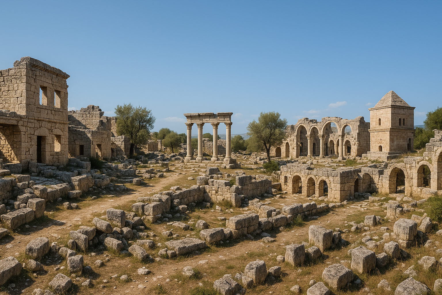
أولبا كانت عاصمة مملكة أولبا القديمة، وهي مركز ديني وإداري قوي في كيليكيا الوعرة (Cilicia Tracheia) في جنوب الأناضول. تقع المدينة على بُعد نحو 4 كم إلى الشرق من أوزونجابورك (ديوقيسارية القديمة)، وتشتهر بـقناتها المائية الرومانية الرائعة -- التي يبلغ طولها 150 مترًا وارتفاعها 25 مترًا، ممتدّةً فوق وادي سيطان ديرسي (وادي الشيطان) -- فضلًا عن النمفايوم (المبنى النافوري) الضخم، والمقبرة الصخرية الواسعة، وبقايا مسرح، وأطلال دير مسيحي مبكّر. سيطرت أسرة ملوك الكهنة التيوكريين الذين حكموا من أولبا على معبد زيوس في ديوقيسارية المهم، ممّا أفرز واحدة من أكثر الكيانات السياسية الثيوقراطية رسوخًا وإثارةً في العالم القديم. تواصل الحفريات التي تقودها جامعة مرسين منذ عام 2001 الكشف عن طبقات جديدة من هذا الموقع الاستثنائي.
جدول المحتويات
- لماذا تُعدّ أولبا مهمة
- الجغرافيا والموقع
- الجدول الزمني التاريخي
- أبرز المعالم الأثرية
- العمل الأثري
- معلومات الزيارة
- الأسئلة الشائعة
- المصادر والقراءات الإضافية
لماذا تُعدّ أولبا مهمة
-
عاصمة أسرة ثيوقراطية فريدة. كانت أولبا مقرّ ملوك الكهنة التيوكريين، وهي أسرة كهنوتية وراثية كان كلّ حاكم ذكر فيها يحمل اسمًا إمّا أياكس أو تيوكروس (نسبةً إلى أبطال حرب طروادة الأسطوريين) بالتناوب. أدارت هذه الأسرة سلطتَي الدين والسياسة معًا في كيليكيا الوعرة لقرون طويلة -- وهو نظام حكم نادر الحدوث بشكل استثنائي في العالم القديم.
-
تحفة من روائع الهندسة الهيدروليكية الرومانية. قناة أولبا المائية، المشيّدة في عهد الإمبراطور سبتيموس سيفيروس (193-211م)، إنجاز هندسي مذهل: 150 مترًا طولًا و25 مترًا ارتفاعًا، تمتدّ فوق وادي سيطان ديرسي بصفّين من الأقواس. ويُقرأ على نقش القناة عبارة "مدينة الأولبيين"، ممّا يؤكّد هوية المدينة وفخرها المدني.
-
نظام مدينة توأم مع ديوقيسارية. أدّت أولبا وديوقيسارية (أوزونجابورك) المجاورة دورَي مركزَين متكاملَين: ضمّت ديوقيسارية معبد زيوس أولبيوس المقدّس، فيما خدمت أولبا بوصفها العاصمة الإدارية والسكنية. تشبه هذه العلاقة نموذج ميليتوس-ديديما، حيث ارتبط الحرم المقدّس بمدينة حاكمة.
-
ملتقى طرق التجارة الكيليكية. تقع أولبا عند سفح جبال طوروس على رافد من نهر كاليكادنوس (غوكسو الحديث)، إذ كانت تتحكّم في مسالك رئيسية تربط الساحل الكيليكي بالداخل الأناضولي.
-
مقبرة غنية وتقاليد جنائزية راسخة. تكتظّ جدران وادي سيطان ديرسي بـمقابر صخرية ومقابر تابوتية وأبنية جنائزية تمتدّ عبر قرون متعاقبة، وتوفّر سجلًّا شاملًا لعادات الدفن في كيليكيا الوعرة.
الجغرافيا والموقع
الموقع
تقع أولبا في الهضبة الجبلية شمال سيليفكه في محافظة مرسين، عند سفح جبال طوروس. يرتفع الموقع على رافد من نهر كاليكادنوس (نهر غوكسو)، في مشهد طبيعي تتخلّله أودية عميقة وهضاب كلسية ووديان جبلية خصبة.
التضاريس والطبوغرافيا
تُهيمن وادي سيطان ديرسي على التضاريس الدرامية لأولبا، وهو وادٍ كلسي عميق يشقّ المشهد الطبيعي:
- الوادي: وادٍ حادّ الجدران يبلغ عمقه نحو 25 مترًا، تمتدّ فوقه القناة المائية الرومانية
- الهضبة: المنطقة الاستيطانية الرئيسية على الأرض المستوية نسبيًا فوق الوادي وحوله
- المنحدرات: حيث تمتدّ المقبرة على امتداد الوجوه الصخرية
- الوادي الشرقي: موقع أطلال الدير والمصاطب الزراعية
وفّرت التربة الكلسية مادّة بناء ممتازة وأتاحت نحت القبور الصخرية وقنوات المياه.
المناخ
يتمتّع الهضبة الجبلية الكيليكية بـمناخ متوسطي مرتفع: صيف دافئ جافّ وشتاء بارد أحيانًا مثلج. يُعدّل الارتفاع حدّة الحرارة الصيفية مقارنةً بالساحل، مما جعل المنطقة تاريخيًا وجهة استراحة مرغوبة بعيدًا عن الصيف السهلي.
محور أولبا-ديوقيسارية
ربطت طريق قديم المسافةَ البالغة 4 كم بين أولبا وديوقيسارية، ليُشكّل الموقعان وحدة وظيفية:
- ديوقيسارية (أوزونجابورك): المركز المقدّس الذي يضمّ معبد زيوس أولبيوس (شُيّد نحو 300 ق.م على يد سلوقس الأول نيكاتور)، وبوّابة ضخمة، وشارع بأعمدة، ومسرح
- أولبا: العاصمة الإدارية التي تضمّ القناة المائية والنمفايوم والمسرح والمقبرة والمناطق السكنية
- يُنصح الزوّار بالتخطيط لرؤية كلا الموقعَين معًا للحصول على الصورة الكاملة لنظام المدينة التوأم هذا
الجدول الزمني التاريخي
| الحقبة | التواريخ التقريبية | أبرز التطوّرات |
|---|---|---|
| ما قبل الهلنستي (بيريندو) | القرن السادس ق.م وما قبله | حكم مملكة محلية تُدعى بيريندو المنطقةَ؛ ويُرجَّح أن أولبا كانت عاصمتها |
| الهلنستي / السلوقي | القرن 3 -- القرن 1 ق.م | يُعيد سلوقس الأول نيكاتور بناء معبد زيوس في ديوقيسارية (نحو 300 ق.م)؛ يُرسّخ ملوك الكهنة التيوكريون سلطتهم |
| الجمهورية الرومانية | القرن الأول ق.م | تدخل كيليكيا في دائرة النفوذ الروماني؛ تتحوّل الأسرة التيوكرية من حكّام مستقلين إلى ملوك عملاء حليفين لروما |
| الإمبراطورية الرومانية المبكّرة | القرن 1 -- القرن 2 م | تزدهر المدينة في ظلّ الإدارة الرومانية؛ تُوسَّع المباني المدنية |
| ذروة التطوّر (الحقبة السيفيرية) | أواخر القرن 2 -- مطلع القرن 3 م | بناء القناة المائية في عهد سبتيموس سيفيروس (193-211م)؛ تشييد النمفايوم؛ بلوغ المدينة أقصى ازدهارها |
| أواخر الحقبة الرومانية / البيزنطية المبكّرة | القرن 4 -- القرن 6 م | تصبح أولبا أسقفية مسيحية؛ بناء الدير؛ تشييد الكنائس |
| العصور الوسطى | القرن 7 -- القرن 14 | تراجع تدريجي؛ إعادة توظيف بعض الأبنية |
| العثماني / الحديث | القرن 15 -- الحاضر | استيطان ريفي؛ نموّ الاهتمام الأثري |
ملوك الكهنة التيوكريون
تُعدّ الأسرة التيوكرية من أكثر الكيانات السياسية إثارةً للاهتمام في العالم القديم:
- الأصول: ادّعت الأسرة نسبها من الأبطال الأسطوريين تيوكروس وأياكس، ابنَي تيلامون، اللذَين قاتلا في طروادة
- تقليد التسمية: كان كلّ حاكم ذكر يُسمّى إمّا تيوكروس أو أياكس بالتناوب عبر الأجيال -- استراتيجية نسبية متعمّدة تربط الأسرة بالأساطير البطولية
- الدور المزدوج: اضطلع التيوكريون في آنٍ واحد بمهمّة رؤساء الكهنة لمعبد زيوس أولبيوس في ديوقيسارية وحكّامًا سياسيين للإقليم المحيط، جامعين السلطتَين الدينية والزمنية
- المسكوكات: سكّ ملوك الكهنة عملاتهم الخاصّة التي كانت حاسمة في رسم تسلسل الأسرة الزمني
- الأفول: تحت الضغط الروماني، فقدت الأسرة تدريجيًا استقلاليتها، منتقلةً إلى دور الحكّام العملاء قبل أن تُدمَج كليًّا في النظام الإداري الروماني
مملكة بيريندو
قبل الحقبة الهلنستية، حكمت المنطقة المحيطة بأولبا مملكة محلية تُدعى بيريندو، مذكورة في المصادر الحثّية وما بعدها. ويُعتقد أنّ أولبا كانت عاصمة بيريندو، ممّا يجعل أهمية الموقع السياسية قديمةً بما يتجاوز الآثار اليونانية والرومانية المرئية.
برنامج البناء السيفيري
شهد عهد الإمبراطور سبتيموس سيفيروس (193-211م) استثمارًا ضخمًا في البنية التحتية لأولبا:
- إنشاء القناة المائية الضخمة الممتدّة فوق وادي سيطان ديرسي
- بناء النمفايوم المجاور للقناة المائية
- تحسينات عمرانية تعكس رعاية الأسرة السيفيرية الواسعة لمدن الشرق الروماني
- يعكس نقش "مدينة الأولبيين" على القناة المائية الهوية المدنية وفخر الحقبة
أبرز المعالم الأثرية
القناة المائية
تُعدّ قناة أولبا المائية أكثر معالم الموقع أثرًا بصريًا وأهمّها معماريًا.
- الطول: نحو 150 مترًا
- الارتفاع: نحو 25 مترًا عند أعمق نقطة في الوادي
- البنية: صفّان من الأقواس يمتدّان فوق وادي سيطان ديرسي
- التاريخ: عهد الإمبراطور سبتيموس سيفيروس (193-211م)
- النقش: يحمل نقش "مدينة الأولبيين" (Olbalilarin Kenti)
- مصدر المياه: أحضرت المياه من نهر لاموس (ليمونلو الحديث) عبر منظومة من الأنفاق والقنوات
- الأبراج الحراسية: شُيّدت أبراج محيطة بالقناة لحماية هذا المرفق الحيوي
- الحالة: محفوظة بشكل استثنائي؛ الأقواس والبناء الحجري سليمان في معظمهما؛ تُعدّ من أروع القنوات المائية الرومانية الباقية في جنوب تركيا
يعود بقاء القناة جزئيًا إلى متانة بنائها وجزئيًا إلى عزلة الوادي التي حمتها من نهب حجارتها. ويُشكّل المشي على حافّة الوادي مع امتداد القناة فوق الهوّة أسفلك تجربةً لا تُنسى في أيّ موقع أثري كيليكي.
النمفايوم (النافورة الضخمة)
يقوم النمفايوم بجانب القناة المائية، ليكون نقطة التوزيع الزخرفية للمياه التي تحملها.
- النوع: مبنى نافورة ضخم ذو واجهة زخرفية
- الموقع: بجانب نهاية القناة المائية
- التاريخ: الحقبة السيفيرية (أواخر القرن 2 -- مطلع القرن 3 م)
- المميّزات: واجهة متعدّدة الحنيات نموذجية للنمفايومات الرومانية؛ شظايا معمارية وزخارف منحوتة استُعيد بعضها خلال الحفريات
- الوظيفة: استقبل مياه القناة ووزّعها للاستخدام العام، بينما خدم زينةً مدنية ومظهرًا للرعاية الإمبراطورية
المسرح
رُصدت أجزاء من مسرح في أولبا، وإن كانت أقلّ حفظًا من مسارح ديوقيسارية المجاورة.
- العناصر المحفوظة: أجزاء من المدرّج (الكافيا) ومبنى المسرح (السكيني)
- الموقع: يقوم بجانب النمفايوم
- الحقبة: رومانية، على الأرجح من القرن الثاني م
- الطاقة الاستيعابية: حجم متوسط يتناسب مع حجم سكّان المدينة
المقبرة
تمتدّ مقبرة أولبا على طول جدران وادي سيطان ديرسي، لتُشكّل واحدة من أكثر مناطق الدفن موقعًا درامية في الأناضول.
- الموقع: على طول جدران الوادي، مستفيدةً من الوجوه الصخرية الطبيعية للنحت
- أنواع المقابر:
- مقابر صخرية ذات حجرات: منحوتة في الجرف الصخري بواجهات مزخرفة
- أتابوت (توابيت): صناديق حجرية منفصلة، بعضها بزخرفة بارزة متقنة
- أبنية مشيّدة: مبانٍ قبرية متفاوتة الأحجام
- المدى الزمني: من الحقبة الهلنستية حتى البيزنطية
- النقوش: تحمل عدّة مقابر نقوشًا تُعرّف بالمتوفَّين وتُقدّم معلومات أنسابية
- الأهمية: يُفضي الموقع على حافّة الوادي إلى مشهد جنائزي مُبهر حيث كان الموتى يُشرفون حرفيًا على مدينة الأحياء
مجمّع الدير
تتناثر أطلال دير مسيحي مبكّر ضخم في الوادي إلى الشرق من الأكروبول على رقعة واسعة.
- الحقبة: أواخر الرومانية / البيزنطية المبكّرة (نحو القرن 5 -- القرن 7 م)
- العناصر: أساسات الكنيسة، والخلايا السكنية، وبقايا المأدبة، وصهاريج المياه
- السياق: يعكس أهمية أولبا بوصفها أسقفية مسيحية -- إذ مثّل أسقف أولبا المدينةَ في كبرى مجامع الكنيسة والمجامع الكنسية
- الموقع: قرب منطقة القناة المائية، ممّا يشير إلى أنّ الدير استفاد من منظومة تزويد المياه
أسوار المدينة والأكروبول
- الأكروبول: نقطة مرتفعة محصّنة تُشرف على المستوطنة والوادي
- الأسوار الدفاعية: أقسام من أسوار المدينة من حقب مختلفة تعكس تاريخًا دفاعيًا طويلًا للموقع
- البوّابات: آثار من بوّابات المدينة على امتداد المسالك الرئيسية
العمل الأثري
تاريخ الحفريات
- الاستكشاف المبكّر: وثّق الرحّالة الأوروبيون في القرن التاسع عشر الأطلال الظاهرة، لا سيّما القناة المائية
- المسوحات الأكاديمية: أجرت فرق تركية ودولية مسوحات ميدانية متعدّدة خلال القرن العشرين
- 2001-2009: المرحلة الأولى من التنقيب المنهجي بإشراف أ. آميل إيرتن من جامعة مرسين
- 2010-حتى الآن: مواصلة الحفريات والبحوث بإشراف فريق جامعة مرسين
الاكتشافات الرئيسية
أسفرت حفريات جامعة مرسين عن نتائج بالغة الأهمية:
- تمثال أنثوي عمره 1800 عام: اكتُشفت بقايا تمثال أنثوي من الحقبة الرومانية، تُسهم في فهم البرنامج النحتي للمدينة
- شظايا إفريز: استُعيد شظايا تُصوّر روايات أسطورية، تدلّ على وجود برامج زخرفية راقية في المباني العامة
- أرضيات فسيفساء: اكتُشفت فسيفساء قديمة في سياقات متنوّعة
- مجموعات خزفية ونقدية: تُقدّم أدلّة زمنية تفصيلية على مراحل إشغال المدينة
- التوثيق المعماري: تسجيل منهجي لأبنية القناة المائية والنمفايوم والمقبرة
- تحليل منظومة المياه: دراسة مفصّلة لكيفية تكوين الأنفاق والقنوات والقناة المائية شبكةً هيدروليكية متكاملة
تحدّيات الحفاظ على التراث
- تُعرّض بيئة الوادي الكلسي الأبنيةَ للتآكل الناجم عن تسرّب المياه ودورات التجمّد والذوبان ونموّ النباتات
- تستوجب بعض مقابر المقبرة التثبيت لمنع الانهيار
- تحتاج القناة المائية، رغم سلامتها الهيكلية، إلى رصد مستمر
- البنية التحتية السياحية شحيحة، ممّا يحدّ من إمكانية وصول الزوّار والمبرّر الاقتصادي للاستثمار في الحفاظ على التراث
معلومات الزيارة
الموقع وسبل الوصول
| التفصيل | المعلومات |
|---|---|
| المحافظة | مرسين |
| المقاطعة | سيليفكه |
| المسافة من مركز سيليفكه | نحو 30 كم شمالًا |
| المسافة من أوزونجابورك (ديوقيسارية) | نحو 4 كم شرقًا |
| المسافة من مدينة مرسين | نحو 120 كم غربًا |
| الإحداثيات الجغرافية | نحو 36.62 شمالًا، 33.95 شرقًا |
كيفية الوصول
- بالسيارة من سيليفكه: سِر شمالًا من سيليفكه باتجاه أوزونجابورك. يصعد الطريق المعلَّم جيّدًا نحو تلال طوروس. بعد زيارة أوزونجابورك، تابع نحو 4 كم شرقًا إلى أولبا.
- بالسيارة من مرسين: خُذ الطريق الساحلي D400 إلى سيليفكه، ثمّ اتّبع طريق أوزونجابورك شمالًا. تستغرق الرحلة الإجمالية نحو ساعتين إلى ساعتَين ونصف.
- يُنصح بالزيارة المشتركة: خطّط دائمًا لزيارة أوزونجابورك (ديوقيسارية) وأولبا معًا -- لا تفصل بينهما سوى 4 كم وهما تاريخيًا مجمّع واحد.
مدّة الزيارة
- أولبا وحدها (زيارة سريعة): 45 دقيقة إلى ساعة
- استكشاف شامل لأولبا: 1.5-2.5 ساعة
- أولبا + أوزونجابورك مجتمعتَين: 3-5 ساعات (يُنصح به)
- يوم كامل مع المواقع المحيطة: 6-8 ساعات شاملةً وقت التنقّل
أفضل أوقات الزيارة
- الربيع (أبريل-مايو): ظروف مثالية؛ مشهد أخضر، وأزهار برية في الوادي، ودرجات حرارة مريحة
- الخريف (سبتمبر-أكتوبر): دافئ ومريح؛ إضاءة رائعة لتصوير القناة المائية
- الصيف: حارّ لكنّه أطوع من الساحل بفضل الارتفاع. زُر في الصباح الباكر.
- الشتاء: بارد إلى شديد البرودة؛ ثلج محتمل في الارتفاعات الأعلى. أيام الشتاء الصافية تُقدّم مشاهد وادٍ درامية رائعة.
نصائح عملية
- الأحذية: حذاء متين ضرورة قصوى. التضاريس في منطقة الوادي شديدة الانحدار وغير منتظمة.
- سلامة الوادي: توخَّ الحذر بالقرب من حواف الوادي. لا توجد حواجز أمان.
- الماء والمؤن: احضر ما تحتاجه. تتوفّر مستلزمات أساسية في قرية أوزونجابورك؛ أولبا نفسها شحيحة المرافق.
- التصوير: يُستحسن تصوير القناة المائية الممتدّة فوق الوادي من الحافّة الشرقية في ضوء الصباح. يُضيء ضوء الظهيرة والعصر الوجه الغربي للوادي ومقابر المقبرة.
- إدارة الوقت: لا تتسرّع. مجموع القناة المائية والوادي والمقبرة والنمفايوم يصنع مشهدًا يُقدَّر في أحسن حالاته بإيقاع تأمّلي هادئ.
- رسوم الدخول: تحقّق من الرسوم الحالية. بعض المناطق قد تستوجب تذكرة واحدة مع أوزونجابورك.
زيارات مشتركة
تنسجم منطقة أولبا/أوزونجابورك بامتياز مع مواقع كيليكية أخرى:
- أوزونجابورك (ديوقيسارية): الزيارة المرافقة الأساسية -- معبد زيوس أولبيوس، البوّابة الضخمة، الشارع ذو الأعمدة، المسرح. تبعد 4 كم فقط عن أولبا.
- قلعة سيليفكه: حصن قروسطي مهيب يُشرف على مدينة سيليفكه ووادي نهر غوكسو.
- جنّت وجهنّم (الجنّة والنار): مجاليق دراماتيكية تضمّ كنيسة بيزنطية وكهفًا، تبعد نحو 20 كم جنوبًا.
- قيزكاليسي (كوريكوس): قلعة بحرية وقلعة برية على الساحل، تبعد نحو 60 كم شرقًا.
- آدم قايالار: أشكال بشرية منحوتة في جرف صخري، تبعد نحو 15 كم جنوبًا.
الأسئلة الشائعة
ما العلاقة بين أولبا وأوزونجابورك؟
شكّلا نظام مدينة توأم: كانت أولبا العاصمة الإدارية والمركز السكني، فيما كانت أوزونجابورك (ديوقيسارية القديمة) المركز المقدّس الذي يضمّ معبد زيوس أولبيوس. تحكّم ملوك الكهنة التيوكريون في كلا الموقعَين، وكان الطريق البالغ 4 كم بينهما محورًا موكبيًا وإداريًا. تشبه العلاقة طريقة تحكّم ميليتوس في الحرم البعيد في ديديما عبر الطريق المقدّس. ينبغي للزوّار دائمًا رؤية الموقعَين معًا لفهم المنظومة الكاملة.
من كانوا ملوك الكهنة التيوكريون؟
التيوكريون أسرة وراثية من الحكّام الكهنة جمعوا السلطة الدينية (بوصفهم رؤساء كهنة معبد زيوس) مع السلطة السياسية على كيليكيا الوعرة. ادّعوا نسبهم من أبطال حرب طروادة تيوكروس وأياكس، وكان كلّ حاكم ذكر يُسمّى بالتناوب تيوكروس أو أياكس. سكّوا عملاتهم الخاصّة وحكموا شبه مستقلّين حتى ابتُلعوا تدريجيًا في النظام الإداري الروماني.
هل من الآمن الاقتراب من القناة المائية؟
البنية الإنشائية للقناة مستقرّة، غير أنّ حواف الوادي غير مسيّجة والتضاريس شديدة الانحدار وصخرية. التزم المسارات المعبّدة، وأبقِ مسافة آمنة من حافّة الوادي، وتوخَّ حذرًا خاصًّا مع الأطفال. لا تحاول تسلّق بنية القناة المائية.
كيف تتقاطع أولبا مع أوزونجابورك من حيث الاهتمام السياحي؟
أوزونجابورك أكثر انكشافًا أثريًا وتمتلك معالم في متناول الزوّار بصورة مباشرة (أعمدة معبد زيوس، البوّابة الضخمة، المسرح). أولبا تُقدّم تجربة أكثر وعورةً ومغامرةً مع القناة المائية بوصفها محور المشهد ومقبرة الوادي كعنصر مشهدي درامي. تُقدّم المدينتان معًا تجربتَين متكاملتَين -- أوزونجابورك للعمارة المعبدية الكبرى، وأولبا للهندسة الهيدروليكية والمشهد الجنائزي.
هل يمكن المشي بين أولبا وأوزونجابورك؟
مسافة الـ4 كم قابلة للسير على الأقدام، وفي العصور القديمة كان هذا طريقًا رئيسيًا واصلًا. يمرّ الطريق اليوم على طريق ريفي يناسب المشي في الطقس الجيّد. اسمح بنحو 45-60 دقيقة مشيًا في اتجاه واحد. غير أنّ معظم الزوّار يتنقّلون بالسيارة بين الموقعَين.
هل كانت أولبا مركزًا مسيحيًا مبكّرًا مهمًّا؟
نعم. كانت أولبا مقرّ أسقف مسيحي منذ الحقبة الرومانية المتأخّرة. حضر أسقف أولبا كبرى مجامع الكنيسة والمجامع الكنسية. تؤكّد أطلال الدير الضخمة شرق الأكروبول وشواهد تشييد الكنائس أهمية الموقع في الجغرافيا المسيحية المبكّرة لكيليكيا.
أولبا في السياق الأوسع للمشاهد المقدّسة الكيليكية
تنتمي أولبا وديوقيسارية إلى شبكة أوسع من المراكز المقدّسة والإدارية في كيليكيا الوعرة:
- ديوقيسارية (أوزونجابورك): الشريك المقدّس لأولبا بمعبد زيوس أولبيوس -- 4 كم غربًا
- سيلوقية على الكاليكادنوس (سيليفكه): المدينة الهلنستية والرومانية الكبرى عند مصبّ نهر غوكسو
- كوريكوس (قيزكاليسي): مدينة حصن ساحلية بقلعتَين برية وبحرية
- كانيتيليس (قانلي ديفانه): موقع رائع مبنيّ حول بالوعة ضخمة، يضمّ مقابر أبراج هلنستية ونقشًا رومانيًا
- جنّت وجهنّم: البالوعتان الشهيرتان مع كنيسة بيزنطية
- إلايوسا سيباستي (أياش): مدينة ساحلية كبرى بمسرح وأغورا ومقبرة
يبرز مجمّع أولبا-ديوقيسارية ضمن هذا المشهد بـنموذج الحكم الثيوقراطي الفريد، والهيكل الإداري للمدينة التوأم، والقناة المائية الدرامية الممتدّة فوق الوادي -- ميزات لا تتكرّر في أيّ موقع كيليكي آخر.
معجم المصطلحات الرئيسية
- الأسرة التيوكرية: أسرة ملوك الكهنة الوراثية في أولبا، سُمّيت نسبةً إلى البطل الأسطوري تيوكروس
- النمفايوم: مبنى نافورة ضخم زُيّن بعناية في الغالب، يخدم نقطة توزيع المياه العامّة
- القناة المائية: قناة مياه مهندسة مرفوعة في الغالب على أقواس، تنقل الماء على مسافات بعيدة
- سيطان ديرسي: "وادي الشيطان" -- الوادي الكلسي العميق الذي يُحدّد طبوغرافية أولبا
- ديوقيسارية: "مدينة زيوس" -- المستوطنة المقدّسة (أوزونجابورك الحديثة) التي تضمّ معبد زيوس أولبيوس
- كيليكيا الوعرة (Cilicia Tracheia): القسم الجبلي الغربي من كيليكيا القديمة في جنوب تركيا
- كاليكادنوس: الاسم القديم لنهر غوكسو الجاري في المنطقة
الأدلّة النقدية: مسكوكات ملوك الكهنة التيوكريين
تُعدّ مسكوكات أولبا من المصادر الأساسية لإعادة بناء تسلسل الأسرة التيوكرية وسلطتها الزمنية. ولأنّ ملوك الكهنة سكّوا عملات تحمل أسماءهم وألقابهم، تسدّ الشواهد النقدية الثغرات التي يتركها السجلّ الأدبي الشحيح.
أنواع العملات المعروفة
| الحاكم | التاريخ التقريبي | المعدن / الحجم | الوجه | الظهر | مميّزات بارزة |
|---|---|---|---|---|---|
| أياكس بن تيوكروس | نحو 10-15 م | برونز، 22 مم، ~7.05 غ | نصف تمثال مُعلَّق يمينًا يرتدي قبّعة الكاهن؛ كيريكيون (عصا الرسول) على اليمين | تريسكيليس (رمز القدمَين الثلاث) | يصف الرعايا بـ"شعب كينّاتيس ولالاسيس" |
| تيوكروس (أشكال مختلفة) | القرن 1 ق.م -- القرن 1 م | برونز | نصف تمثال بغطاء رأس كهنوتي | صاعقة زيوس أو واجهة معبد | تأكيد تقليد التسمية المتناوبة تيوكروس/أياكس |
| إصدارات مدنية أولبية مجهولة | مطلع القرن 2 م | برونز | تجسيد المدينة أو صورة إمبراطورية | برج مشرّف | رسم السكّان لبرج تحصينهم على المسكوكات |
يتوافق البرج المشرَّف المرسوم على مسكوكات أولبا من القرن الثاني الميلادي مع أطلال الأبراج الفعلية لا تزال ظاهرة في الموقع. يدلّ اختيار السكّان نقش تحصيناتهم على العملات على أنّ البرج الدفاعي كان مصدر فخر مدني وشعارًا معترفًا به لهوية المدينة.
إعادة بناء الأسرة من المسكوكات
أدّت الشواهد النقدية دورًا محوريًا في تحديد تعاقب ملوك الكهنة:
- تيوكروس الأوّل (طاراسياريس) -- أقدم حاكم مشهود له
- أياكس الأوّل -- ابن تيوكروس الأوّل
- تيوكروس الثاني -- ابن أياكس الأوّل
- يتواصل التناوب المتعاقب لاسمَي أياكس/تيوكروس عبر ستّة أجيال موثّقة على الأقلّ
- الانتقال الأخير إلى الإدارة الإقليمية الرومانية في عهد الأسرة الفلافية (أواخر القرن الأول م)
معبد زيوس أولبيوس في ديوقيسارية: القياسات المعمارية
كان معبد زيوس أولبيوس في ديوقيسارية المجاورة (4 كم من أولبا) المركز الروحي الذي تحكّم فيه ملوك الكهنة التيوكريون. يُقدّم التوثيق المعماري الدقيق سياقًا حيويًا لفهم الأهمية الدينية لأولبا.
| المعيار | القياس / التفصيل |
|---|---|
| نوع المعبد | محيطي (محاط بأعمدة) |
| ترتيب الأعمدة | 6 × 12 عمودًا |
| نظام الأعمدة | كورنثي -- أقدم معبد كورنثي محيطي في آسيا الصغرى |
| تاريخ البناء | نحو 300 ق.م، في عهد سلوقس الأول نيكاتور (ح. 312-281 ق.م) |
| الباني | سلوقس الأول نيكاتور، مؤكَّد بنقش اكتشفه رودولف هيبردي وأدولف فيلهلم |
| التيمينوس (الحرم المقدّس) | فناء مستطيل يحيط بالمعبد مقتصر على الوصول الاحتفالي |
| التحوّل اللاحق | كنيسة (الحقبة البيزنطية)، ممّا أسهم في الحفظ الجيّد نسبيًا للمعبد |
أُرسيَ التعريف بسلوقس الأول نيكاتور بانيًا للمعبد باكتشاف نقش إبّان استكشافات القرن التاسع عشر على يد هيبردي وفيلهلم. وفّر شكل الرأس المزهّر الكورنثي دليلًا معماريًا إضافيًا على التأريخ. يُمثّل معبد ديوقيسارية، إلى جانب معبد زيوس في أيورموس، أحد أرقى النماذج الباقية للعمارة الكورنثية المحيطية في آسيا الصغرى.
تسلسل الحفريات وجدول الاكتشافات
| السنة / الحقبة | النشاط | الفريق / المدير | النتائج الرئيسية |
|---|---|---|---|
| القرن التاسع عشر | أوّل توثيق أوروبي | هيبردي وفيلهلم وعدد من الرحّالة | رسم القناة المائية والأطلال الظاهرة؛ اكتشاف نقش سلوقس الأوّل |
| 1970 | تصنيف الحماية الرسمي | وزارة الثقافة التركية | حماية رسمية للموقع؛ الحدّ من نهب الحجارة |
| 2001-2009 | أوّل حفريات منهجية | أ. آميل إيرتن، جامعة مرسين | توثيق النمفايوم؛ مسح المقبرة؛ بدء تنظيف الأكروبول |
| 2010-حتى الآن | مواصلة الحفريات | فريق جامعة مرسين | تمثال أنثوي عمره 1800 عام؛ شظايا إفريز بمشاهد أسطورية؛ أرضيات فسيفساء؛ مجموعات خزفية ونقدية؛ رسم خرائط المجمّع الديري |
| العشرينيات من القرن 21 | تحليل المنظومة الهيدروليكية | جامعة مرسين | دراسة متكاملة للأنفاق والقنوات والقناة المائية بوصفها شبكة موحّدة لتزويد المياه من نهر لاموس |
هندسة القناة المائية: تحليل تقني
قناة أولبا المائية إنجاز رائع من إنجازات الهندسة الهيدروليكية الرومانية الإقليمية. تكشف القياسات التفصيلية عن مستوى رفيع من التصميم.
| المعيار | القياس / التفصيل |
|---|---|
| الامتداد الكلي | ~150 مترًا فوق وادي سيطان ديرسي |
| الارتفاع الأقصى | ~25 مترًا عند أعمق نقطة في الوادي |
| البنية | صفّان من الأقواس (قوس فوق قوس) |
| تاريخ البناء | عهد سبتيموس سيفيروس، 193-211م |
| نقش الإهداء | "مدينة الأولبيين" (Olbalilarin Kenti) |
| مصدر المياه | نهر لاموس (ليمونلو جايي الحديث) |
| طريقة النقل | أنفاق وقنوات مفتوحة تؤدّي إلى جسر القناة المائية |
| الميزات الدفاعية | أبراج حراسة شُيّدت حول القناة المائية لحماية إمداد المياه |
| الحالة | سليمة في معظمها؛ الأقواس والبناء الحجري باقيان بفضل عزلة الوادي التي منعت نهب الحجارة |
كان تصميم القوسَين المتراكبَين ضروريًا لأنّ صفًّا واحدًا من الأقواس كان عاجزًا عن بلوغ الارتفاع البالغ 25 مترًا اللازم للحفاظ على انحدار قناة المياه عبر الوادي. الأبراج الحراسية المحيطة بالقناة ظاهرة غير معتادة تدلّ على أنّ هذا الإمداد المائي كان يُعدّ بالغ الأهمية الاستراتيجية -- إذ كان تدميره مصيبة كارثية للمدينة.
المصادر والقراءات الإضافية
- Wikipedia -- Olba (ancient city)
- Wikipedia -- Olba Aqueduct
- Turkish Archaeological News -- Olba Site Profile
- Artichaeology -- Olba / Diocaesarea Ancient City
- Livius -- Olba-Diocaesarea
- Slow Travel Guide -- Olba Ancient Site
- EBSCO Research Starters -- Olba History
- Anatolian Archaeology -- 1,800-Year-Old Female Statue and Frieze Fragments Discovered at Olba
- Following Hadrian Photography -- Olba-Diocaesarea
- JAHA -- An Evaluation of the Olba Nymphaeum and Its Coins
- Mersin Provincial Directorate of Culture and Tourism -- Official documentation