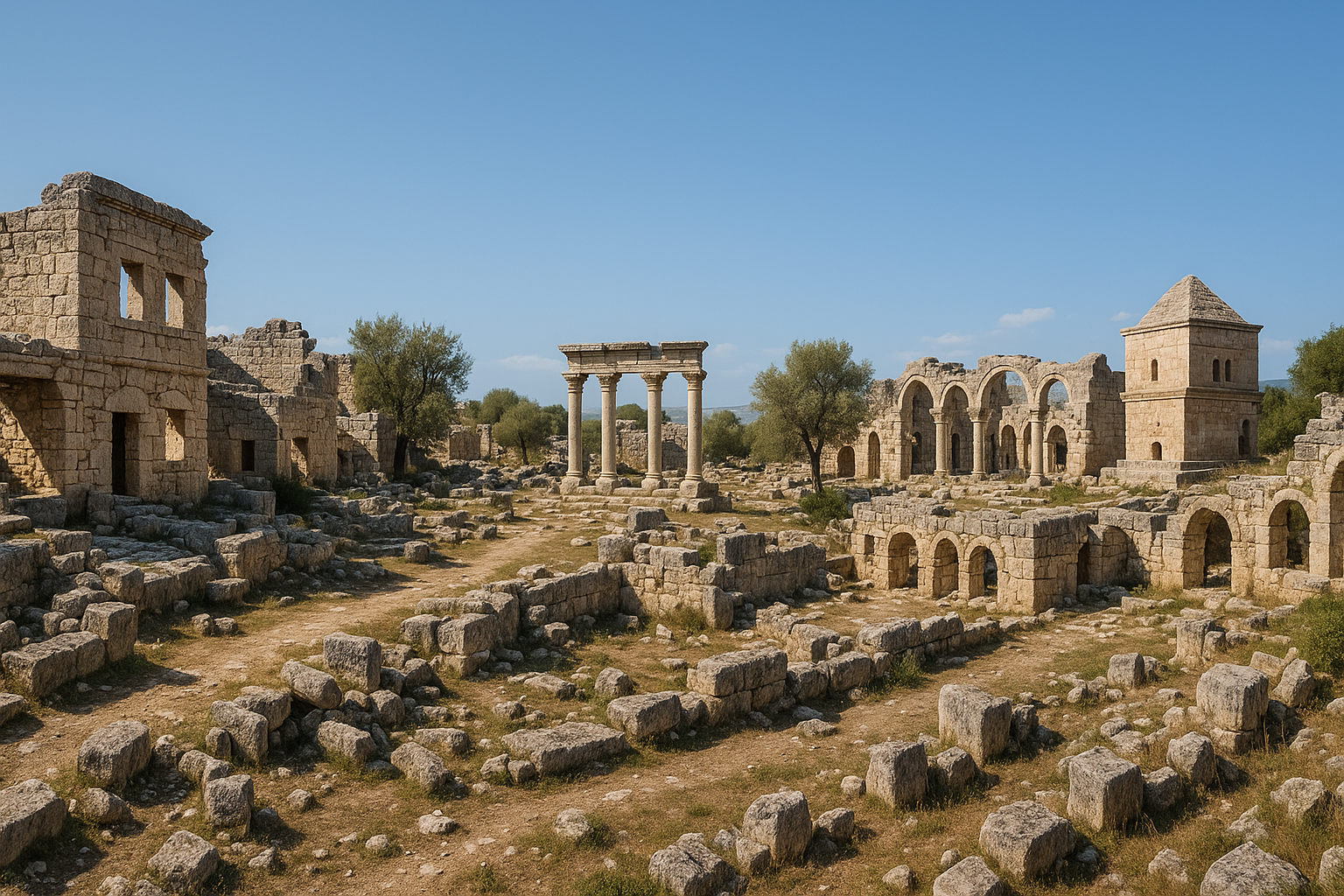
سولي-بومبيوبوليس من أهم مدن الموانئ القديمة على ساحل البحر المتوسط الشرقي في تركيا، وتقع في منطقة مزيتلي بمدينة مرسين الحديثة. أسّسها مستوطنون رودسيون حوالي عام 700 ق.م.، فازدهرت مركزًا تجاريًا وثقافيًا لأكثر من ألف عام. وبعد أن دمّرها القراصنة، أعاد بناءها القائد الروماني بومبيوس الكبير عام 67 ق.م. وأعاد تسميتها بومبيوبوليس ("مدينة بومبيوس"). وتظلّ الشارع ذو الأعمدة الأيقوني -- الممتد 450 مترًا بأعمدة كورنثية تحمل منحوتات نصفية للأباطرة والآلهة -- المعلمَ الرئيسيَّ للموقع. وقد أعطت سولي اللغةَ الإنجليزية كلمة "solecism" (الخطأ اللغوي)، انعكاسًا للهجة اليونانية المميزة التي كان يتحدث بها سكانها.
جدول المحتويات
- لماذا تستحق سولي-بومبيوبوليس الاهتمام
- الجغرافيا والموقع
- الجدول الزمني التاريخي
- أبرز المعالم الأثرية
- الشارع ذو الأعمدة بالتفصيل
- الأعمال الأثرية
- معلومات الزيارة
- الأسئلة الشائعة
- المصادر وقراءات إضافية
لماذا تستحق سولي-بومبيوبوليس الاهتمام
تستحق سولي-بومبيوبوليس مكانًا بارزًا في أي جولة عبر مدن تركيا القديمة للأسباب التالية:
-
مهد كلمة في اللغة. تنحدر كلمة "solecism" الإنجليزية (الخطأ النحوي أو المخالفة الآدابية) من اليونانية soloikismos، إشارةً إلى اليونانية "غير الصحيحة" التي كان يتحدث بها مستوطنو سولي، إذ مزجوا لهجتهم الرودسية بتأثيرات كيليكية محلية. وهذا الارتباط الاشتقاقي يجعل سولي فريدةً بين المدن القديمة.
-
موطن أراتوس. ألّف الشاعر والفلكي الهلنستي الشهير أراتوس السولي (نحو 315--240 ق.م.) قصيدته التعليمية فينومينا في الظواهر الفلكية، وكانت من أكثر الأعمال انتشارًا في العالم القديم، وترجمها إلى اللاتينية كلٌّ من شيشرون وجرمانيكوس، ودرستها المدارس لقرون.
-
المدينة النموذجية لبومبيوس. بعد تطهير البحر المتوسط من القراصنة عام 67 ق.م.، أعاد بومبيوس توطين القراصنة المأسورين واللاجئين المحليين في سولي، وضخّ استثمارات ضخمة في البنية التحتية لخلق مدينة رومانية نموذجية. وجاءت إعادة التسمية إلى بومبيوبوليس رمزًا للنظام الروماني الجديد في كيليكيا الشرقية.
-
أحد أكبر الموانئ القديمة في شرق البحر المتوسط. يمتدّ رصيف الميناء الغربي 160 مترًا، ويبلغ طول الميناء الإجمالي 320 مترًا، ويستخدم تقنية الخرسانة المائية -- سمةً مميزة للهندسة الرومانية المتقدمة.
-
موقع أثري حيّ داخل مدينة حديثة. على خلاف الأطلال النائية، تقع سولي-بومبيوبوليس في قلب النسيج العمراني لمرسين، مما يجعلها من أكثر المواقع الأثرية سهولةً في تركيا، وهي مشروع متحف مفتوح في طور التنفيذ.
الجغرافيا والموقع
تحتلّ سولي-بومبيوبوليس سهلًا ساحليًا مستويًا في حي فيران شهير بمنطقة مزيتلي، مطلّةً مباشرةً على شاطئ البحر المتوسط. كان الميناء القديم للمدينة متجهًا جنوبًا نحو البحر المفتوح، فيما امتدّ الشارع ذو الأعمدة داخليًا على محور شمال-جنوب.
نمت مدينة مرسين الحديثة (التي يزيد عدد سكانها على 1.8 مليون نسمة) حول المدينة القديمة وفوقها في معظمها، مما جعل عمليات التنقيب تسيرَ بحذر شديد في إطار علم آثار المناطق الحضرية. وتتركّز الأطلال الباقية في منطقة أثرية محددة بالقرب من الساحل.
| السمة | التفاصيل |
|---|---|
| الموقع | فيران شهير، مزيتلي، مرسين |
| الساحل | واجهة مباشرة على البحر المتوسط |
| المنطقة القديمة | كيليكيا بيدياس (كيليكيا المستوية) |
| أقرب مطار | مطار مرسين-أضنة (شاكيرباشا)، نحو 70 كم |
| المناخ | متوسطي حار؛ شتاء معتدل |
| الارتفاع | مستوى سطح البحر |
يُعدّ السهل الساحلي الكيليكي (جوكوروفا) من أخصب المناطق الزراعية في تركيا، وكان في العصور القديمة يحتضن شبكة كثيفة من المدن المرتبطة بالتجارة البحرية. وقد منح موقع سولي المدينةَ سيطرةً على طرق الشحن الساحلية وعلى التجارة الداخلية عبر وديان الأنهار المؤدية إلى جبال طوروس.
الجدول الزمني التاريخي
التأسيس والحقبة الأرخائية (نحو 700--500 ق.م.)
أسّس مستوطنون يونانيون من جزيرة رودس، وبحسب بعض المصادر من ليندوس، مدينة سولي حوالي عام 700 ق.م. ونمت المستوطنة سريعًا لتصبح ميناءً مهمًا، مستفيدةً من الميناء الطبيعي والسهل الكيليكي الخصيب. وبحلول القرن السادس ق.م. كانت سولي قد بلغت من الازدهار ما أتاح لها سكّ عملاتها الفضية الخاصة التي تضمّنت في الغالب صور العنب وأثينا والأمازون المحاربة.
الحقبة الفارسية (نحو 500--333 ق.م.)
في ظل حكم الفرس الأخمينيين، أصبحت سولي عاصمة مقاطعة فرعية في كيليكيا. وحافظت المدينة على قدر كبير من الاستقلالية، مستمرةً في سكّ العملات وممارسة التجارة البحرية. وأسهمت سولي بسفن في الأسطول الفارسي إبان الحروب الفارسية-اليونانية. ولما مرّ الإسكندر الأكبر بكيليكيا عام 333 ق.م. فرض غرامةً باهظةً على سولي بسبب دعمها السابق للفرس.
الحقبة الهلنستية (333--67 ق.م.)
بعد الإسكندر، انتقلت سولي بين أيدي الإمبراطورية السلوقية ثم المملكة البطلمية في خضمّ تنافس الدول الخلفاء على السيطرة على كيليكيا. وفي هذا العصر عاش أراتوس السولي (نحو 315--240 ق.م.) وكتب فينومينا الشهيرة. وكان الفيلسوف خريسيبوس (نحو 279--206 ق.م.)، الرئيس الثالث للمدرسة الرواقية، من أبناء سولي أيضًا. وبحلول القرن الأول ق.م. كانت القرصنة المتفشية في شرق البحر المتوسط قد أنهكت المدينة وأوقعتها في الخراب.
إعادة التأسيس الرومانية: بومبيوبوليس (67 ق.م. فصاعدًا)
في عام 67 ق.م.، مُنح القائد الروماني غناوس بومبيوس ماغنوس (بومبيوس الكبير) صلاحيات استثنائية للقضاء على القرصنة في البحر المتوسط. وعقب حملة خاطفة، أعاد توطين القراصنة المأسورين والسكان النازحين في عدد من المدن الكيليكية، منها سولي. فأُعيد بناء المدينة على نطاق واسع وأُعيد تسميتها بومبيوبوليس، وشرع في تشييد مبانٍ عامة جديدة وبناء الميناء والشارع ذي الأعمدة الأيقوني أو الإتمام في بنائها خلال هذه الحقبة.
الازدهار الإمبراطوري (القرنان الأول حتى الثالث الميلادي)
في ظل الإمبراطورية الرومانية، ازدهرت بومبيوبوليس ميناءً تجاريًا رئيسيًا. وزار الإمبراطور هادريان المدينةَ عام 130م وقدّم دعمًا ماليًا لبناء الميناء. وزُيّن الشارع ذو الأعمدة بأعمدة تحمل تماثيل نصفية للأباطرة والآلهة. وبلغت المدينة ذروتها المعمارية في القرنين الثاني والثالث الميلاديين.
أواخر العصور القديمة والتراجع (القرنان الرابع حتى السابع الميلادي)
غدت بومبيوبوليس مركزًا مسيحيًا مبكرًا مهمًا وكرسيًا أسقفيًا. غير أن الزلازل المتكررة وتراكم الطمي في الميناء قلّصا أهمية المدينة تدريجيًا. وبحلول موجات الغارات العربية في القرن السابع الميلادي كانت المدينة قد هُجرت إلى حدٍّ بعيد.
أبرز المعالم الأثرية
الشارع ذو الأعمدة
المعلم الرئيسي لسولي-بومبيوبوليس هو الشارع ذو الأعمدة الرائع الذي امتدّ 450 مترًا من الميناء باتجاه الداخل نحو مركز المدينة. يبلغ عرض الشارع 14.5 مترًا، وكان مصطفًّا في الأصل بما يُقدَّر بـ200 عمود كورنثي. وقد أُعيد نصب 47 عمودًا حتى الآن في ضوء الحفريات الأخيرة. وتحمل تيجان الأعمدة ودعاماتها تماثيل نصفية منحوتة للأباطرة الرومانيين (من بينهم بالبينوس) وللآلهة كـأسكليبيوس وهيجيا وزيوس ونيميسيس وديميتر وديونيسوس.
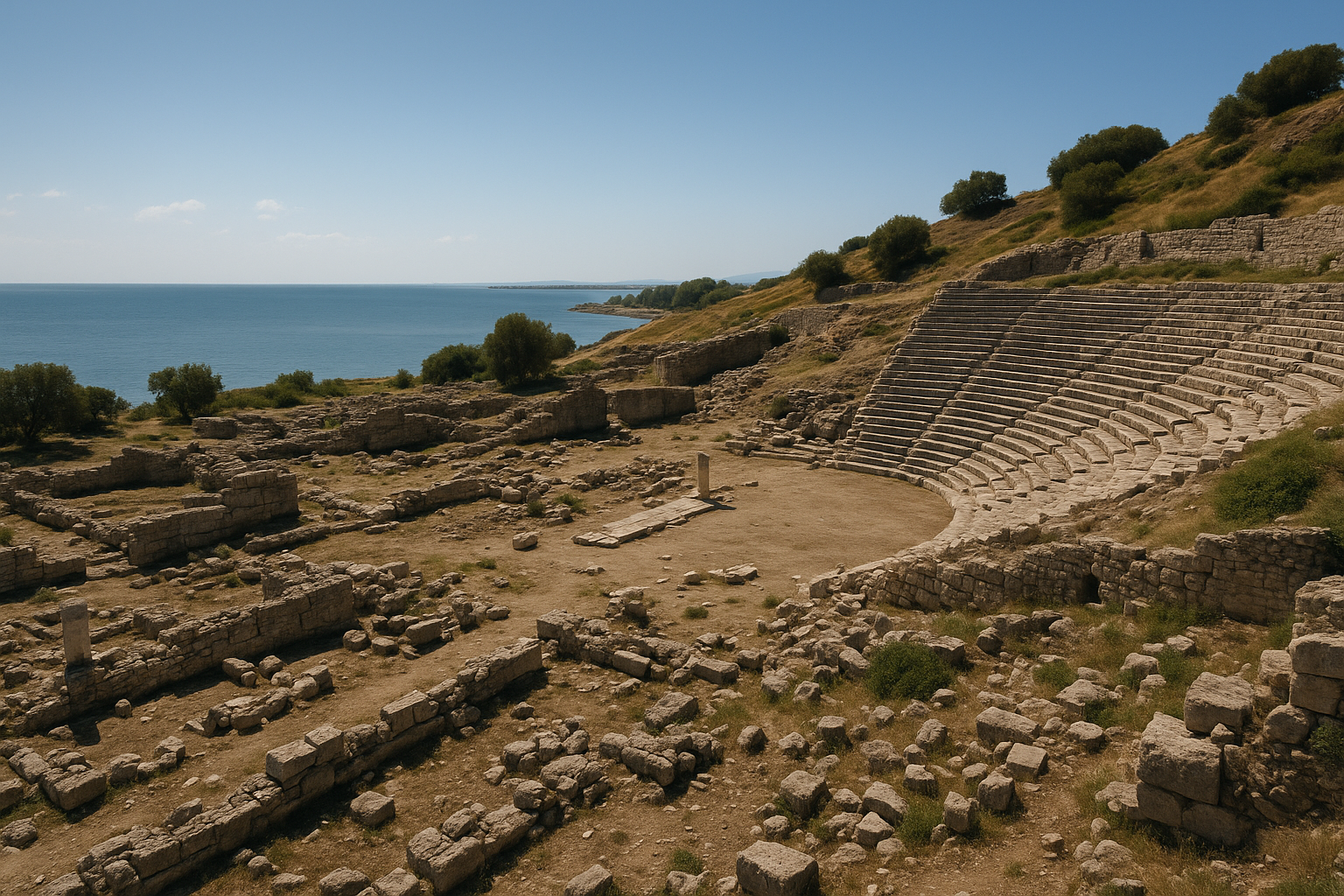
الميناء القديم
كان ميناء سولي-بومبيوبوليس من أكبر الموانئ في شرق البحر المتوسط، ويتميز بـ:
- الرصيف الغربي: طوله 160 مترًا
- الطول الإجمالي للميناء: 320 مترًا
- عرض المدخل بين الرصيفين: 180 مترًا
- مادة البناء: الخرسانة المائية (أوبوس كيمينتيشيوم)، دليلٌ على التطور الهندسي الروماني
وكشفت المسوحات الأثرية تحت الماء عن بنية الميناء بالتفصيل. ويُنسب إلى الإمبراطور هادريان تمويلُ تحسينات جوهرية للميناء خلال زيارته عام 130م.
الحي السكني والفسيفساء
كشفت الحفريات عن أجزاء من حي سكني بأرضيات فسيفسائية تضمّ أنماطًا هندسية ومشاهد أسطورية. وتعود هذه الفسيفساءات في معظمها إلى القرنين الثاني والرابع الميلاديين، وتدلّ على ثروات النخبة الحضرية في بومبيوبوليس.
مدينة الأموات
رُصدت مدينة أموات (مقبرة) مهمة على أطراف المدينة القديمة، تضمّ مقابر محفورة في الصخر وتوابيتَ وحجراتِ دفن تمتد عبر حقب متعاقبة من العصر الهلنستي حتى البيزنطي.
أسوار المدينة
رُصدت بقايا أسوار التحصين في مواقع متفرقة، وإن كان كثيرًا منها قد طالته التطوير العمراني الحديث. ويبدو أن الأسوار تعود أساسًا إلى الحقبتين الهلنستية والرومانية.
الحمامات
رُصدت أجزاء من مجمع حمام روماني واحد على الأقل بالقرب من الشارع ذي الأعمدة، بسماته المعتادة من أرضيات هيبوكوست وكسوة رخامية.
الشارع ذو الأعمدة بالتفصيل
يستحق الشارع ذو الأعمدة اهتمامًا خاصًا لكونه أبرز معالم الموقع وأكثرها إثارةً للإعجاب:
- الاتجاه: شمال-جنوب، يربط الميناء بداخل المدينة
- الطول الكلي: 450 مترًا
- العرض: 14.5 مترًا (شاملًا الأرصفة والأروقة)
- عدد الأعمدة الأصلية: يُقدَّر بـ 200 عمود
- الأعمدة الباقية/المُعاد نصبها: 47 عمودًا
- طراز الأعمدة: كورنثي، بتيجان منحوتة بإتقان
- الميزة الفريدة: دعامات بروزية تحمل تماثيل نصفية
والتماثيل النصفية على الدعامات لافتةٌ لأنها تجمع بين صور إمبراطورية (توفّر أدلةً تأريخية) وشخصيات إلهية (تكشف الحياة الدينية للمدينة). ومن الشخصيات المحددة:
| الشخصية | النوع | الأهمية |
|---|---|---|
| بالبينوس | إمبراطور روماني (238م) | يوفر تاريخًا حدًّا أدنى للتأريخ |
| أسكليبيوس | إله الشفاء | يدل على وجود طائفة طبية |
| هيجيا | ربة الصحة | رفيقة أسكليبيوس |
| زيوس | ملك الآلهة | الإله الراعي الرئيسي |
| نيميسيس | ربة الانتقام | شائعة في مدن الموانئ |
| ديميتر | ربة الحصاد | تعكس الاقتصاد الزراعي |
| ديونيسوس | إله الخمر | ارتباط بتجارة الخمر |
وبالسير على هذا الشارع يستطيع الزوار تخيّل الحياة التجارية النابضة التي كانت تملأ الأروقة يومًا: تجارٌ يبيعون البضائع القادمة من أرجاء البحر المتوسط، ومسافرون نازلون من السفن الراسية في الميناء، ومواطنون يلتئمون في المهرجانات المدنية والدينية.
الأعمال الأثرية
الاكتشافات المبكرة (الستينيات--الثمانينيات)
أجرت مديرية متحف مرسين في الستينيات والثمانينيات حفريات إنقاذية ركّزت على توثيق الشارع ذي الأعمدة في وجه التهديدات الناجمة عن التوسع العمراني الحديث.
الحفريات المنهجية (1999--حتى الآن)
بدأت أولى الحفريات العلمية المنهجية عام 1999 بقيادة أ.د. رمزي ياغجي من جامعة دوكوز إيلول، بالتعاون مع وزارة الثقافة والسياحة. ومن أبرز الإنجازات:
- الكشف عن 47 عمودًا من الشارع ذي الأعمدة وإعادة نصبها
- توثيق الدعامات الحاملة للتماثيل النصفية بالتفصيل
- التنقيب في أجزاء من الحي السكني بأرضياته الفسيفسائية
- إجراء مسوحات تحت الماء لبنية الميناء
حفريات الميناء
نُشر البحث الأثري تحت الماء في الميناء في مجلة الأثريات البحرية الدولية، كاشفًا عن استخدام الخرسانة المائية والحجم الهائل للهندسة الرومانية في الميناء بسولي.
مشروع المتنزه الأثري
ثمة مبادرة جارية تهدف إلى تحويل سولي-بومبيوبوليس إلى متحف مفتوح أو منتزه أثري، يدمج الموقع الأثري مع البيئة الحضرية الحديثة. وقد صرّح الأستاذ ياغجي: "هدفنا إقامة الصلة بين المناطق التي نجري بها الحفريات وتحويل هذا المكان إلى منتزه أثري."
البحث عن قبر أراتوس
في السنوات الأخيرة، يبحث علماء الآثار بنشاط عن قبر أراتوس، الشاعر والفلكي الشهير، داخل منطقة مدينة الأموات. وعلى الرغم من عدم تحديد القبر بصورة قاطعة حتى الآن، أسفر البحث عن اكتشافات جديدة مهمة.
معلومات الزيارة
الوصول إلى الموقع
- داخل مرسين: تقع سولي-بومبيوبوليس في حي فيران شهير بمنطقة مزيتلي، ويمكن الوصول إليها بسهولة عبر حافلة المدينة أو سيارة الأجرة أو السيارة الخاصة من وسط مرسين (نحو 10 كم غربًا).
- من أضنة: خذ الطريق السريع O-51 غربًا (نحو 70 كم، ساعة واحدة).
- من أنطاليا: اتبع الطريق الساحلي D-400 شرقًا (نحو 550 كم، 7 ساعات) أو اطر إلى أضنة ثم اقد السيارة.
داخل الموقع
- الدخول: للمنطقة الأثرية حدود محددة. تحقق محليًا من أحدث أوضاع الوصول وأي رسوم دخول.
- التضاريس: مسطّح في معظمه وسهل المشي؛ مناسب لجميع مستويات اللياقة البدنية.
- المدة: خصّص من 1.5 إلى 3 ساعات لجولة كاملة تشمل الشارع ذا الأعمدة ومنطقة الميناء وأي مناطق حفر مفتوحة.
أفضل وقت للزيارة
- الربيع (مارس--مايو) والخريف (أكتوبر--نوفمبر) مثاليان للطقس المعتدل.
- الصيف حار ورطب على الساحل؛ يُنصح بالزيارة الصباحية.
- الشتاء معتدل في مرسين، مما يجعلها وجهةً صالحة للزيارة على مدار العام.
جولات مشتركة
- متحف مرسين: يضمّ قطعًا أثرية من سولي-بومبيوبوليس، منها العملات والفخار والشظايا النحتية.
- طرسوس (30 كم شرقًا): مسقط رأس القديس بولس، بتراثه الأثري الغني.
- قيزقالاسي (قوريقوس) (60 كم جنوب غرب): قلعة بحرية درامية ومدينة قديمة.
- أوزونجابورج (ديوقيصرية) (80 كم غربًا): معبد هلنستي وشارع ذو أعمدة روماني في الجبال.
نصائح
- يقع الموقع داخل منطقة حضرية حديثة، فالمطاعم والمقاهي والمحلات التجارية قريبة.
- يمنح ضوء أواخر فترة الظهيرة فرصًا رائعة للتصوير حين تمتد ظلال الأعمدة.
- اجمع زيارتك بالتجوّل على كورنيش مرسين البحري.
- انتبه إلى التماثيل النصفية المنحوتة على دعامات الأعمدة -- فهي السمة الأكثر تميزًا في الموقع.
الأسئلة الشائعة
ما الصلة بين سولي وكلمة "solecism" (الخطأ اللغوي)؟
تأتي كلمة solecism (بمعنى خطأ نحوي أو هفوة اجتماعية) من اليونانية soloikismos، في إشارة إلى طريقة سكان سولي في التحدث باليونانية. كانت لهجتهم تُعدّ "غير صحيحة" بالمعايير الأثينية لأنها مزجت اليونانية الرودسية بتأثيرات لغوية كيليكية محلية. وقد صمدت هذه الكلمة لأكثر من 2,000 سنة شاهدًا على التميز الثقافي لسولي.
من هو أراتوس السولي؟
أراتوس (نحو 315--240 ق.م.) شاعر وفلكي هلنستي وُلد في سولي. وعمله الرئيسي فينومينا قصيدة تعليمية تصف الأبراج وعلامات الطقس. وقد غدت من أكثر النصوص انتشارًا في العالم القديم، وترجمها إلى اللاتينية شيشرون وجرمانيكوس قيصر والشاعر الروماني المتأخر أفيينوس. واستشهد القديس بولس بأراتوس في خطابه في أثينا: "لأننا أيضًا ذريته" (أعمال الرسل 17: 28). وقضى أراتوس معظم مسيرته في بلاط أنتيغونوس الثاني غوناتاس في مقدونيا.
كم عمودًا من الشارع ذي الأعمدة لا يزال قائمًا؟
بحسب آخر الحفريات، أُعيد نصب 47 عمودًا من أصل نحو 200 عمود أصلي. وتتواصل أعمال الحفر والترميم بهدف الكشف عن مزيد من الشارع.
هل يمكنني مشاهدة الميناء القديم؟
منطقة الميناء مرئية جزئيًا، وقد وثّقت المسوحات الأثرية تحت الماء بنيتها بالتفصيل. ويمكن ملاحظة بعض معالم الميناء من الشاطئ، وإن كانت أكثر الأجزاء تفصيلًا تحت الماء وليست في متناول الزوار العاديين دائمًا.
هل تحوّل سولي-بومبيوبوليس إلى متحف؟
نعم. ثمة مشروع منتزه أثري فعّال يهدف إلى تحويل الموقع إلى متحف مفتوح متكامل يربط مناطق الحفر المختلفة ويوفر مرافق للزوار ولوحاتٍ تفسيريةً ومسارات للمشي.
كيف تُقارن سولي بغيرها من الشوارع ذات الأعمدة في تركيا؟
تضم تركيا عدة شوارع ذات أعمدة شهيرة (أفسوس، بيرجي، سيدي، أباميا). وتتميز سولي-بومبيوبوليس بـالتماثيل النصفية المنحوتة على دعامات أعمدتها، وهي نادرة في العالم الروماني. كما يُفرز اتصالها المباشر بالميناء محورًا بصريًا فريدًا.
الشواهد النقودية: عملة سولي-بومبيوبوليس
يُعدّ السجل النقودي لسولي من أطول السجلات في كيليكيا، إذ يمتد من القرن السادس ق.م. حتى حقبة الإمبراطورية الرومانية. وتوثّق العملات التحولاتِ السياسية للمدينة وأنشطتها الاقتصادية وطوائفها الدينية بتفصيل رائع.
أنواع العملات حسب الحقبة
| الحقبة | المعدن | الوجه | الظهر | الوزن / الحجم | الأهمية |
|---|---|---|---|---|---|
| القرنان السادس والخامس ق.م. | فضة (إستاتير) | رأس أثينا بخوذة ذات عرف (بعضها بزخرفة غريفون) | صورة أمازون؛ أو عنقود عنب | ~10.5--10.9 غ (معيار فارسي) | من أقدم الفضة الكيليكية؛ تؤكد الهوية الاستعمارية الرودسية |
| نحو 350--330 ق.م. | فضة (إستاتير) | أثينا بخوذة ذات عرف وغريفون قافز | عنقود عنب؛ نقش SOLEON | ~10.5 غ | طراز أرخائي-كلاسيكي رفيع؛ محفوظ في المتحف البريطاني وجمعية النقود الأمريكية |
| الحقبة الهلنستية | فضة وبرونز | صور ملكية سلوقية/بطلمية متنوعة | رموز المدينة؛ آلهة محلية | متنوع | يعكس التأرجح بين السيطرة السلوقية والبطلمية على كيليكيا |
| الحقبة الاستعمارية الرومانية | برونز | صورة إمبراطورية (مثل أنطونينوس بيوس) | ميناء بومبيوبوليس؛ مقدمة سفينة؛ نقوش لاتينية | متنوع | صوّرت عملات أنطونينوس بيوس (138--161م) الميناء؛ شاهد نقودي معماري فريد |
| القرن الثالث الميلادي | برونز | تمثال نصفي إمبراطوري (مثل بالبينوس، 238م) | الشارع ذو الأعمدة؛ واجهات معابد | متنوع | يؤيد التسلسل الزمني لبناء الشارع ذي الأعمدة |
إن برونزية أنطونينوس بيوس بالغة الأهمية بشكل خاص: تصوّر ظهرها ميناء بومبيوبوليس مما يجعلها التصوير البصري القديم الوحيد المعروف لتخطيط الميناء. وقد استُعين بهذا الدليل النقودي، إلى جانب المسوحات الأثرية تحت الماء، في إعادة بناء التخطيط الأصلي للميناء.
هندسة الميناء: قياسات تفصيلية
أجرى فريق البحث الأثري تحت الماء عام 2017 الذي نشر نتائجه في مجلة الأثريات البحرية الدولية مراجعةً للأوصاف المنشورة سابقًا لبنية الميناء.
| المعامل | القياس |
|---|---|
| طول الرصيف الغربي | 160 م |
| الطول الكلي للميناء (ش-ج) | 320 م |
| عرض المدخل بين الرصيفين | 180 م |
| مادة البناء | خرسانة مائية (أوبوس كيمينتيشيوم) مع رماد بركاني (بوتزولانا) |
| عمق حوض الميناء | متغير، 2--6 م في العصور القديمة |
| الراعي الإمبراطوري | الإمبراطور هادريان الذي زار المدينة وموّل التحسينات عام 130م |
طعن مسح عام 2017 تحت الماء في عدد من إعادة البناء المنشورة سابقًا لمخطط الميناء، لا سيما فيما يخص تكوين الرصيف الشرقي. ويُثبت استخدام الخرسانة المائية -- المصنوعة بمزج الرماد البركاني مع الجير ومياه البحر -- أن المهندسين الرومان في سولي كانوا على دراية بتقنية البناء المتقدمة ذاتها المستخدمة في الموانئ الإيطالية الكبرى كبوتيولي وقيصرية ماريتيما. وقد أثبتت أبحاث المواد الحديثة أن الخرسانة البحرية الرومانية تزداد متانةً بمرور القرون مع نمو بلورات الألومنيوم توبيرموريت في مصفوفتها تحت تأثير مياه البحر.
تسلسل الحفريات والاكتشافات الأخيرة
| السنة / الحقبة | النشاط | المدير / المؤسسة | النتائج الرئيسية |
|---|---|---|---|
| الستينيات--الثمانينيات | حفريات إنقاذية | مديرية متحف مرسين | توثيق الشارع ذي الأعمدة؛ استرداد الخزف والعملات ورؤوس التماثيل لمتحف مرسين |
| 1999 | بدء الحفريات المنهجية | أ.د. رمزي ياغجي، جامعة دوكوز إيلول | رصد طبقات استيطانية من العصر البرونزي-الحيثي وبداية العصر الحديدي تحت المستويات الهلنستية/الرومانية |
| 1999--2010s | ترميم الشارع ذي الأعمدة | فريق ياغجي | إعادة نصب 47 من ~200 عمود؛ 33 منها تحتفظ بتيجانها الأصلية؛ توثيق الدعامات الحاملة للتماثيل النصفية |
| 2016--2017 | مسح الميناء تحت الماء | فريق الأثريات تحت الماء | رسم خرائط للرصيفين من الخرسانة المائية؛ مراجعة الأوصاف المنشورة سابقًا للميناء |
| 2020s | مدينة الأموات والحي السكني | فريق ياغجي / علم الآثار الإنقاذي | البحث عن قبر أراتوس؛ أرضيات فسيفسائية في الحي السكني؛ دراسة جيومورفولوجية للميناء |
| 2024 | حفريات إنقاذية متجددة | الفريق الإقليمي لمرسين | اكتشاف 8 مقابر رومانية وقناة مائية رومانية وبقايا معمارية في قطعة أرض فيلا داخل حدود المدينة القديمة |
جاءت حفريات الإنقاذ عام 2024 استجابةً لأعمال بناء حديثة في قطعة أرض فيلا خاصة داخل حدود المدينة القديمة. وكشف اكتشاف ثمانية مقابر رومانية وقناة مائية رومانية وبقايا معمارية ضخمة أن رواسب أثرية مهمة لا تزال كامنةً تحت النسيج الحضري الحديث لمزيتلي، مما يعزز إلحاحية مشروع المنتزه الأثري.
شارع الأعمدة: تحليل التيجان والتماثيل النصفية
من بين الـ47 عمودًا المُعاد نصبها، تحتفظ 33 منها بتيجانها الكورنثية الأصلية. وتحافظ الصفوف الجنوبية من الأعمدة على دعامات بروزية كانت تدعم في الأصل تماثيل نصفية -- وهو عنصر زخرفي نادر للغاية في العالم الروماني.
| التمثال النصفي / الشخصية | النوع | طريقة التعرف | دلالة التأريخ |
|---|---|---|---|
| بالبينوس | إمبراطور روماني | المقارنة بالصور النقدية الإمبراطورية المعروفة لعام 238م | يوفر تاريخًا حدًّا أدنى: التماثيل النصفية مثبّتة لا قبل عام 238م |
| أسكليبيوس | إله الشفاء | صفة عصا الثعبان | يدل على وجود طائفة طبية أو أسكليبيون في المدينة |
| هيجيا | ربة الصحة | مقترنة بأسكليبيوس؛ صفة إطعام الثعبان | تؤكد مجمع طائفة الشفاء |
| زيوس | الإله الرئيسي | الصاعقة؛ وضعية العرش | الإله الراعي المدني المعتاد |
| نيميسيس | ربة الانتقام | صفات الميزان والعجلة | شائعة في مدن الموانئ حارسةً من الظلم البحري |
| ديميتر | ربة الحصاد | حزمة الحبوب؛ المشعل | تعكس الثروة الزراعية للسهل الكيليكي |
| ديونيسوس | إله الخمر | تاج اللبلاب؛ الثيرسوس | يؤكد اقتصاد الكروم وتجارة الخمر عبر الميناء |
يُمثّل تمثال الإمبراطور بالبينوس النصفي (الذي حكم ثلاثة أشهر فحسب عام 238م قبل اغتياله) علامةً زمنية بالغة القيمة. إذ يؤكد حضور صورته على الشارع ذي الأعمدة أن برنامج التماثيل النصفية كان لا يزال يُحدَّث في منتصف القرن الثالث الميلادي، مما يدل على استمرار الاستثمار المدني والرعاية الإمبراطورية حتى في خضم أزمة القرن الثالث.
المصادر وقراءات إضافية
- ويكيبيديا: سولي، كيليكيا
- أخبار الآثار التركية: سولي (بومبيوبوليس)
- هورييت ديلي نيوز: بدء الحفريات في سولي بومبيوبوليس
- وكالة الأناضول: سولي-بومبيوبوليس ستتحول إلى منتزه أثري
- ديلي صباح: سولي بومبيوبوليس التركية ستكون متحفًا مفتوحًا
- غو تركيه: حفريات في ميناء عمره 1,800 عام
- إيسيز مرسين: مدينة سولي بومبيوبوليس القديمة
- تصوير فولوينج هادريان: سولي/بومبيوبوليس
مشاهير سولي
أنجبت سولي عدة شخصيات بارزة في عالم الفكر القديم:
أراتوس السولي (نحو 315--240 ق.م.)
أشهر أبناء سولي، أراتوس ألّف فينومينا، قصيدة تعليمية من نحو 1,150 سطرًا تصف الأبراج وعلامات الطقس. استندت القصيدة إلى العمل الفلكي لـأيدوكسوس الكنيدوسي وبلغت شهرةً واسعة. وترجمها إلى اللاتينية شيشرون (في مرحلة الشباب) وجرمانيكوس قيصر والشاعر الروماني المتأخر أفيينوس. واستشهد القديس بولس بأراتوس في خطابه بأثينا: "لأننا أيضًا ذريته" (أعمال الرسل 17: 28). وقضى أراتوس معظم مسيرته في بلاط أنتيغونوس الثاني غوناتاس في مقدونيا.
خريسيبوس السولي (نحو 279--206 ق.م.)
خريسيبوس الرئيس الثالث للمدرسة الرواقية في الفلسفة، خلفًا لكليانتيس. وُلد في سولي وانتقل إلى أثينا ليغدو من أكثر الكتّاب غزارةً في العصور القديمة، إذ يُنسب إليه تأليف أكثر من 700 عمل (لا يبقى أيٌّ منها كاملًا). نظّم المنطق الرواقي والفيزياء الرواقية وعُدّ بالغ الأهمية لدرجة أن القدماء قالوا: "لو لم يكن خريسيبوس لما كانت الرواقية."
فيليمون السولي (نحو 362--262 ق.م.)
وُلد الشاعر الكوميدي فيليمون في سولي (وإن أصبح لاحقًا مواطنًا أثينيًا) وكان شخصيةً بارزة في الكوميديا الجديدة، منافسًا ميناندر. وقد اقتبس المسرحي الروماني بلاوتوس مسرحياته لاحقًا.
سولي والقرصنة الكيليكية
كان تدمير سولي على يد القراصنة في القرن الأول ق.م. جزءًا من أزمة أشمل:
-
الخلفية: بحلول مطلع القرن الأول ق.م. بلغت القرصنة في شرق البحر المتوسط حدَّ الوباء. وكانت أساطيل القراصنة تنطلق من قواعد على الساحل الكيليكي الوعر (كيليكيا تراخيا) لتعطّل التجارة وتغير على المدن الساحلية وتعترض إمدادات الحبوب الحيوية لروما.
-
أثرها على سولي: بوصفها مدينةً ساحلية مزدهرة ومكشوفة، كانت سولي هدفًا رئيسيًا، فهاجمها القراصنة ونهبوها واختطفوا سكانها عبيدًا ودمّروا معظم بنيتها التحتية.
-
حملة بومبيوس: في عام 67 ق.م.، منح قانون ليكس غابينيا بومبيوسَ قيادةً غير مسبوقة على البحر المتوسط بأسره لقمع القرصنة. قسّم بومبيوس البحر إلى ثلاثة عشر قطاعًا وجاب القراصنة منهجيًا من الغرب إلى الشرق. وأُنجزت الحملة في ثلاثة أشهر فحسب -- إحدى أكثر العمليات العسكرية كفاءةً في التاريخ الروماني.
-
إعادة التوطين: بدلًا من إعدام القراصنة المأسورين، انتهج بومبيوس سياسة إعادة التوطين، إذ نقلهم إلى مناطق داخلية مقلّة السكان ومدن متراجعة كسولي. واعتُبر هذا النهج الإنساني مبتكرًا في عصره وأنهى أزمة القرصنة فعليًا.
-
الإرث: حوّلت إعادة التوطين سولي-بومبيوبوليس إلى مجتمع متعدد الثقافات يمزج بين اليونانيين والكيليكيين وشعوب متنوعة من البحر المتوسط.
الصلة بإله الشمس
يرتبط اسم "سولي" لغويًا بالكلمة اليونانية للشمس (هيليوس/سول)، والتصوير الشمسي بارز في أيقونوغرافيا المدينة:
- شواهد العملات: تحمل كثير من عملات سولي رأس إله الشمس (هيليوس/سول) مرتديًا تاجًا ذا أشعة
- الأهمية الثقافية: قد يعكس الارتباط الشمسي طائفةً مبكرة لإله الشمس في الموقع، ربما قبل الاستعمار اليوناني
- جدل التسمية: يتناقش الباحثون في ما إذا كانت المدينة سُمّيت نسبةً إلى الشمس أم أن الارتباط محض مصادفة. وقد جاء المستوطنون الرودسيون من جزيرة اشتُهرت بـتمثال الجبار -- التمثال العملاق لإله الشمس هيليوس
هندسة الميناء: الخرسانة المائية الرومانية
يجسّد الميناء في سولي-بومبيوبوليس إحدى أبرز الابتكارات الهندسية الرومانية -- الخرسانة المائية (أوبوس كيمينتيشيوم):
- التركيبة: صُنعت الخرسانة المائية الرومانية بمزج الرماد البركاني (بوتزولانا) مع الجير ومياه البحر، مما أنتج موادَّ قابلةً للتصليب والتصلّب تحت الماء
- المتانة: أثبتت الأبحاث الحديثة أن الخرسانة المائية الرومانية تزداد متانةً بمرور الوقت عند غمرها في مياه البحر مع نمو البلورات المعدنية في مصفوفتها
- تطبيقها في سولي: شُيّدت أرصفة الميناء باستخدام هذه التقنية، مما أتاح للرومان بناء أساسات ضخمة تحت الماء في ظروف البحر المفتوح
- الأهمية العلمية: يُعدّ ميناء سولي-بومبيوبوليس دراسةَ حالة مهمة للباحثين في تقنية الخرسانة القديمة وتطبيقاتها الحديثة المحتملة
مسرد المصطلحات الرئيسية
- الشارع ذو الأعمدة (كاردو): جادة فخمة مصطفّة بالأعمدة، كانت عادةً الشارع الرئيسي شمال-جنوب في المدن الرومانية
- الطراز الكورنثي: أكثر الطرازات اليونانية المعمارية زخرفةً، بتيجان مزيّنة بأوراق الأكانثوس
- الخرسانة المائية: مادة بناء رومانية تتصلّب تحت الماء، مصنوعة من الرماد البركاني
- مدينة الأموات (نيكروبوليس): مقبرة، بمعنى حرفي "مدينة الأموات"
- المنتزه الأثري: مفهوم حديث يجمع بين الموقع الأثري وبنية متحفية ومرافق للزوار
- الدعامة البروزية: دعامة ناتئة على عمود تحمل تمثالًا نصفيًا أو عنصرًا زخرفيًا
- تاريخ الحد الأدنى (Terminus post quem): مصطلح تأريخي يعني "أقدم تاريخ ممكن"، يُحدَّد بموضوع وُجد في سياق معين
- السوليكيسم (Solecism): خطأ نحوي أو هفوة آدابية، مشتق من أنماط كلام سكان سولي
- الرصيف البحري: منشأة تحمي الميناء من الأمواج والتيارات
- البوتزولانا: رماد بركاني يُستخدم مكوّنًا رئيسيًا في الخرسانة المائية الرومانية
عملة سولي-بومبيوبوليس
سكّت سولي عملاتها منذ القرن السادس ق.م. على الأقل، مما يجعل سجلها النقودي من أطول السجلات في كيليكيا:
- الحقبة الأرخائية: إستاتيرات وأوبولات فضية تحمل صور العنب وأثينا والأمازون
- الحقبة الكلاسيكية: إصدارات في ظل السيادة الفارسية تصوّر في الغالب آلهةً محلية
- الحقبة الهلنستية: إصدارات برونزية وفضية تعكس النفوذ السلوقي والبطلمي
- الحقبة الاستعمارية الرومانية: إصدارات برونزية تحمل صورًا إمبراطورية ونقوشًا لاتينية، مؤرِّخةً للهوية الجديدة للمدينة بوصفها بومبيوبوليس
يعكس دافع العنب على العملات المبكرة أهمية زراعة الكروم في الاقتصاد الساحلي الكيليكي. وقد تُحيل صورة الأمازون إلى أسطورة تأسيسية تربط سولي بالمحاربات الأسطوريات، وهو دافع مشترك مع عدد من المدن الاستعمارية الأخرى في شرق البحر المتوسط.
تُحفظ عملات سولي في مجموعات نقودية كبرى حول العالم، منها المتحف البريطاني وجمعية النقود الأمريكية ومتاحف إسطنبول الأثرية.
ملخص الجدول الزمني
| التاريخ | الحدث |
|---|---|
| نحو 700 ق.م. | التأسيس على يد مستوطنين رودسيين |
| القرن السادس ق.م. | سكّ أول عملة فضية |
| 500--333 ق.م. | الحقبة الفارسية؛ سولي عاصمة مقاطعة فرعية |
| 333 ق.م. | الإسكندر الأكبر يفرض غرامةً على سولي |
| نحو 315--240 ق.م. | حياة أراتوس السولي |
| نحو 279--206 ق.م. | حياة خريسيبوس السولي |
| القرن الأول ق.م. | تدمير المدينة على يد قراصنة كيليكيا |
| 67 ق.م. | بومبيوس يُعيد بناء المدينة وتُسمَّى بومبيوبوليس |
| 130م | الإمبراطور هادريان يزور المدينة ويموّل تحسينات الميناء |
| 238م | وضع التمثال النصفي للإمبراطور بالبينوس على الشارع ذي الأعمدة |
| القرن الرابع--السابع | بومبيوبوليس أسقفية مسيحية مبكرة |
| القرن السابع | هجر المدينة إلى حدٍّ بعيد في أعقاب الغارات العربية |
| 1999 | بدء الحفريات المنهجية بإشراف أ.د. رمزي ياغجي |
| مستمر | مشروع المنتزه الأثري لتحويل الموقع إلى متحف مفتوح |