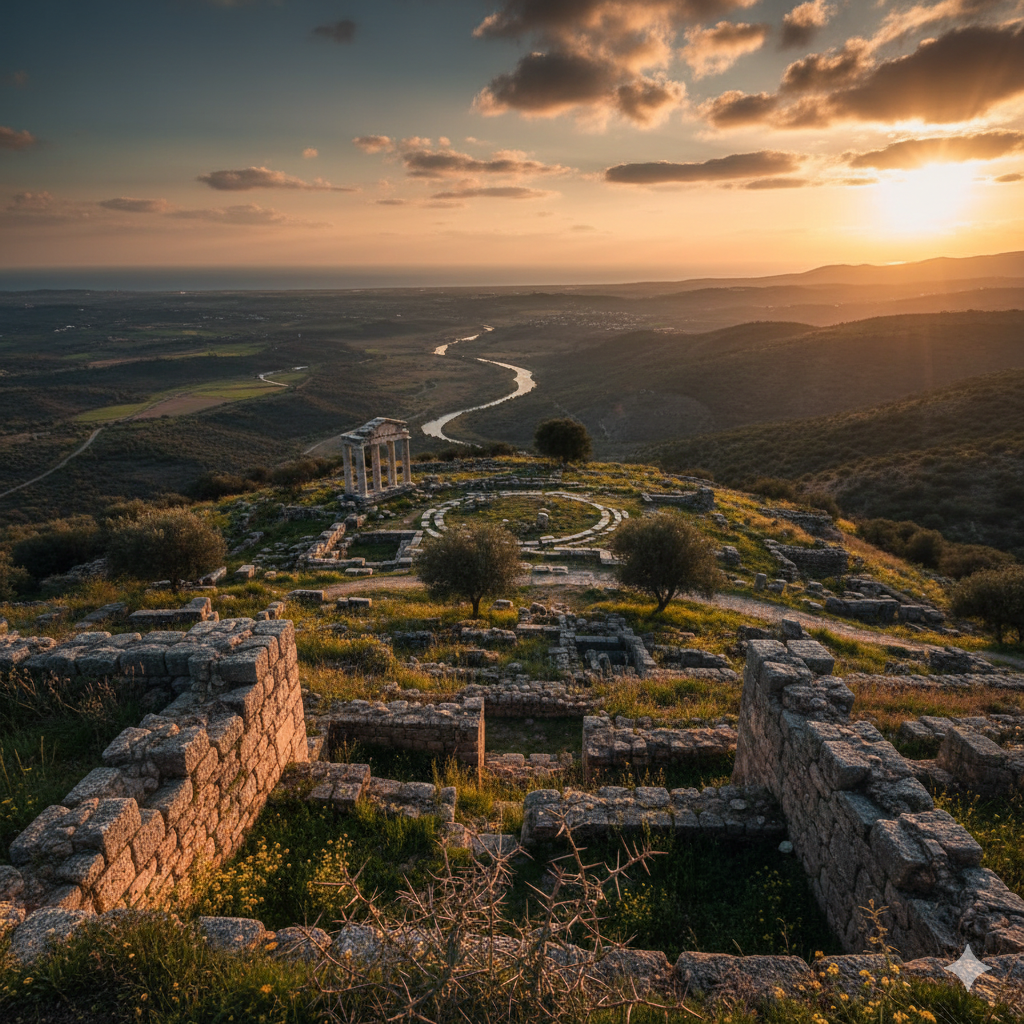
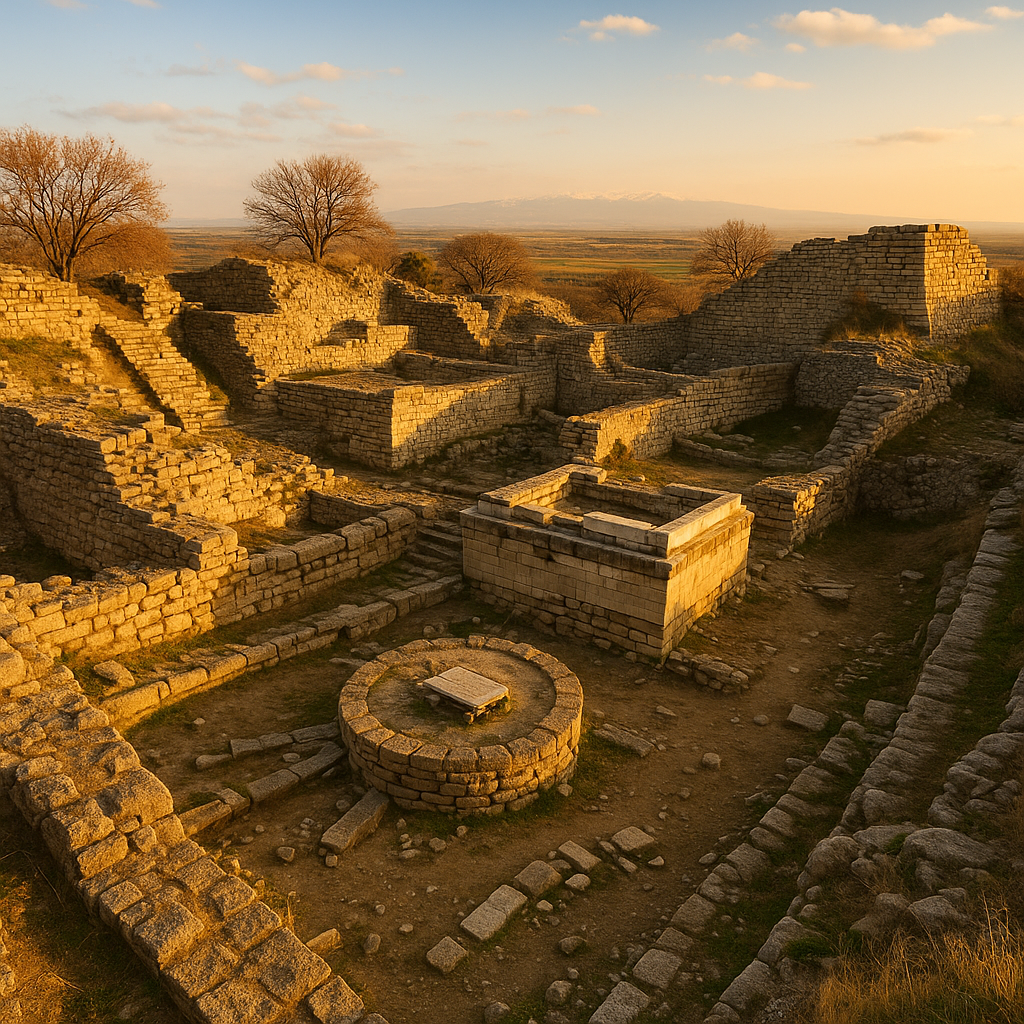
ملخّص سريع: أسوس مدينة إغريقية قديمة تقع قرب قرية بهرام قلعة الحديثة في منطقة أيواجيك بمحافظة تشاناك قلعة، على الساحل الجنوبي من ترواد، تطلّ على خليج أدراميتيون وجزيرة لِسبوس. تشغل المدينة تلّة بركانية شديدة الانحدار ترتفع نحو 235 m فوق سطح البحر، ممّا يمنحها إطلالات مهيبة على البرّ والبحر.
جدول المحتويات
- لماذا يهمّ هذا الموقع
- الخلفية التاريخية والجدول الزمني
- دليل القراءة الأثرية
- كيف تختبر الموقع بشكل أفضل
- ملاحظات سفر موسمية (بما في ذلك الشتاء)
- عدسة قصصية للزوّار
- الأسئلة الشائعة
- المصادر
لماذا يهمّ هذا الموقع
أسوس مدينة إغريقية قديمة تقع قرب قرية بهرام قلعة الحديثة في منطقة أيواجيك بمحافظة تشاناك قلعة، على الساحل الجنوبي من ترواد، تطلّ على خليج أدراميتيون وجزيرة لِسبوس. تشغل المدينة تلّة بركانية شديدة الانحدار ترتفع نحو 235 m فوق سطح البحر، ممّا يمنحها إطلالات مهيبة على البرّ والبحر.
ليس هذا الموقع وجهة أثرية فحسب، بل سجلٌّ ثقافي طويل المدى. وهو يساعد الزوّار على فهم كيف تغيّرت الحياة الحضرية، والتجارة، ومنظومات المعتقد، والسلطة السياسية عبر الزمن في الأناضول.
الخلفية التاريخية والجدول الزمني
لقراءة هذا الموقع تاريخيًا، فكّر في طبقات بدلًا من تاريخ واحد: فترة التأسيس، ومرحلة التوسّع، والتحوّل تحت قوى جديدة، والحياة الآخرة في الذاكرة المتأخرة القديمة/المتوسّطة.
دليل القراءة الأثرية
عند المشي في الموقع، استخدم هذا الترتيب:
- نقطة التوجّه – حدّد التضاريس والوضع الاستراتيجي.
- المعلَم المميِّز – المسرح، أو المعبد، أو الأكروبوليس، أو البوّابة، أو مجمّع المرفأ.
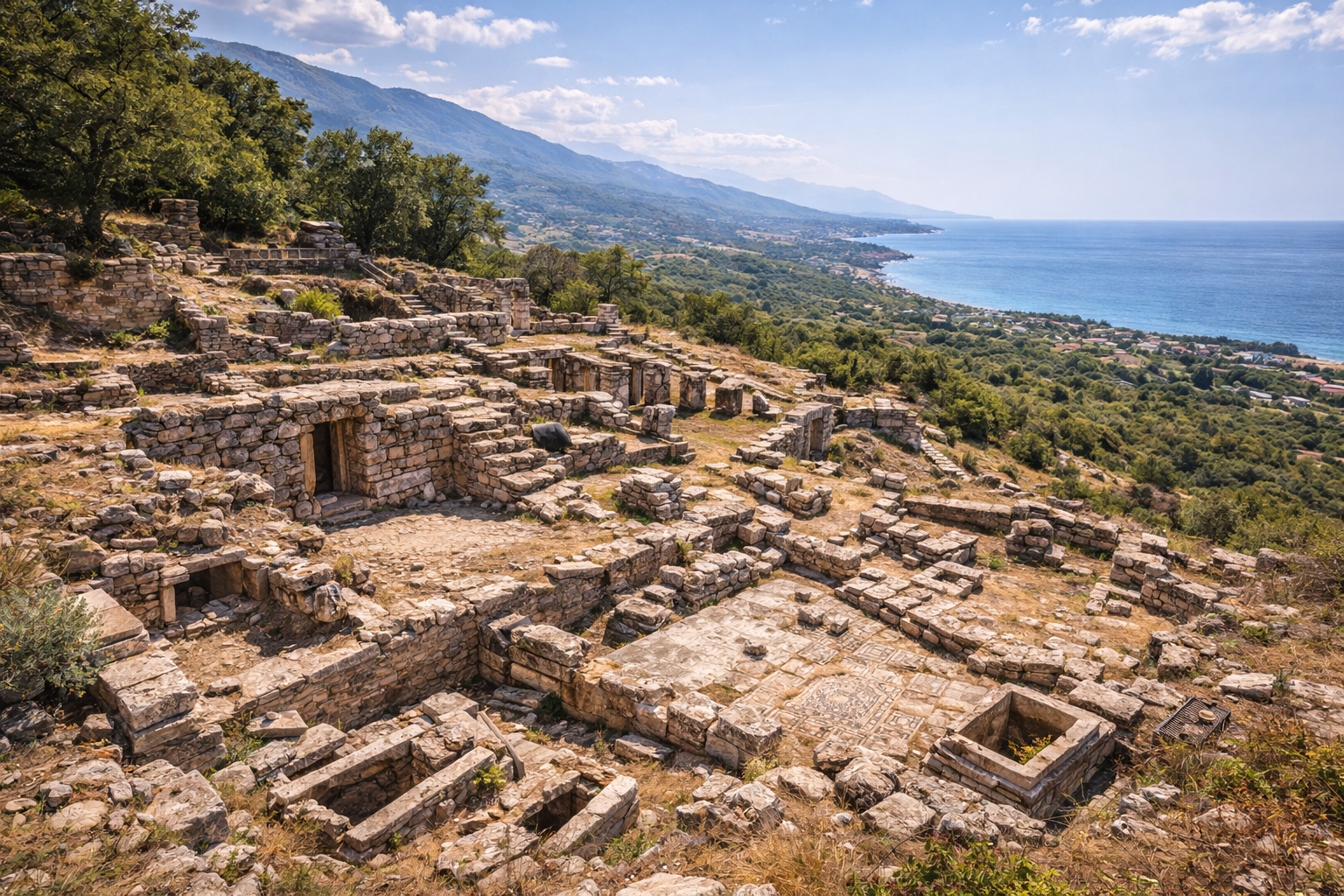
- طبقة الحياة اليومية – الشوارع، وورش العمل، والحمامات، والتخزين، وأنظمة المياه.
- العلاقة بالمشهد – افهم لماذا وُجدت هذه المدينة هنا بالضبط.
هذا المنهج يحوّل المشية السريعة إلى زيارة تفسيرية.
كيف تختبر الموقع بشكل أفضل
- خطّط لوقت كافٍ (ساعتان على الأقلّ لفهم ذي معنى).
- اقرأ السياق قبل الوصول، ثم تحقّق منه مقابل الأطلال.
- استخدم الموقع كنقطة ارتكاز لمسار، لا كتوقّف صورة واحدة.
- ادمج العمارة مع ملاحظة المشهد للتفسير الكامل.
ملاحظات سفر موسمية (بما في ذلك الشتاء)
- الربيع / الخريف: عمومًا أفضل راحة وظروف للمشي.
- الصيف: ابدأ مبكرًا؛ يمكن لحرارة منتصف النهار أن تُقلِّل من جودة التجربة.
- الشتاء: غالبًا أكثر هدوءًا وأفضل للقراءة البطيئة للموقع؛ تحقّق من تغييرات المطر/الرياح وساعات العمل مسبقًا.
عدسة قصصية للزوّار
تخيّل الوصول إلى هنا قبل قرون عند أوّل ضوء: حركة عند البوابات أو المرفأ، أصوات من فضاءات السوق، نشاط طقسي في المناطق المقدّسة، وحياة إدارية في المباني المدنية. البقايا المرئية اليوم هي أجزاء من تلك الأنماط اليومية المتكرّرة.
الأسئلة الشائعة
ما الذي يجعل مدينة أسوس القديمة (بهرام قلعة) في تشاناك قلعة مهمة بشكل خاصّ؟
تأتي أهميتها من الاستمرارية التاريخية، والوضوح الأثري، والتأثير الثقافي الإقليمي.
كم من الوقت ينبغي أن أخصّص؟
يحتاج معظم الزوّار 2–3 ساعات؛ يمكن للزيارات المتقدّمة أن تستغرق نصف يوم.
هل هذا مناسب للمسافرين لأوّل مرة في علم الآثار؟
نعم. يمكن للمبتدئين الاستمتاع بالموقع إذا زاروه بخطة طريق واضحة.
هل الشتاء وقت سيّئ للزيارة؟
ليس بالضرورة. يمكن أن يكون الشتاء ممتازًا للاستكشاف بحشود قليلة إذا كان الطقس مناسبًا.
ما الذي يجب إعطاؤه الأولوية إذا كان وقتي قصيرًا؟
المعلَم المميِّز، ومنطقة حياة يومية واحدة، ونقطة منظر طبيعية قوية واحدة.
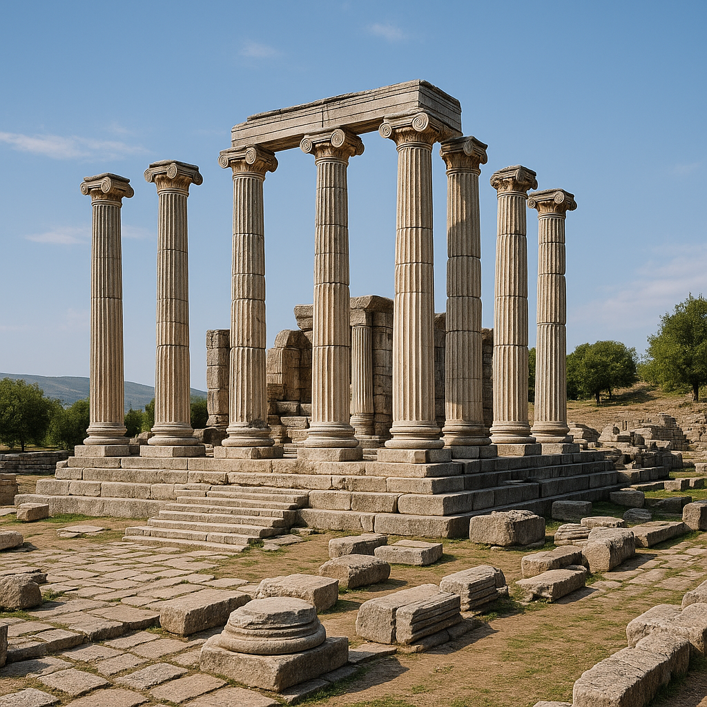
معبد أثينا: القياسات المعمارية والبرنامج النحتي
معبد أثينا في أسوس هو المعبد الدوري الأركي الوحيد المعروف في آسيا الصغرى، ممّا يجعله فريدًا معماريًا في كامل المنطقة الأناضولية. ومزيجه بين النظام البنيوي الدوري وزخرفة الفريز المستمر بالأسلوب الإيوني لا نظير له.
الأبعاد المعمارية
| المعيار | القياس |
|---|---|
| نوع المعبد | محاط بأعمدة (أعمدة على جميع الجهات الأربع) |
| أبعاد المخطط | 30.31 x 14.03 m (الستيلوبات) |
| ترتيب الأعمدة | 6 x 13 عمودًا دوريًا |
| العدد الأصلي للأعمدة | 38 |
| الأعمدة الباقية في موقعها | 6 (أُعيد تنصيب 5 في الثمانينيات باستخدام عناصر أصلية) |
| تاريخ البناء | نحو 530 ق.م |
| النظام المعماري | دوري، مع إفريز إبيستيل (عتب) إيوني فريد |
| مادة الصخر | أنديزيت محلّي (حجر بركاني) |
| الارتفاع | 235 m فوق سطح البحر (قمّة الأكروبوليس) |
أكثر سمات المعبد غرابة هي إبيستيله المنحوت (إفريز العتب). في المعابد الدورية القياسية، يكون العتب سادة ويظهر النحت فقط في الميتوبات والوُجَيهات. أمّا في أسوس، فقد نُحت إفريز سردي مستمرّ عبر العتب على طريقة العمارة الإيونية. هذا التصميم الدوري-الإيوني الهجين فريد بين المعابد الأركية الباقية.
الزخرفة النحتية ومجموعات المتاحف
استُخرجت الزخرفة البارزة من معبد أثينا في 1880–1881 من قبل المعهد الأثري الأمريكي — ممّا يجعله أوّل تنقيب يرعاه المعهد الأثري الأمريكي على الإطلاق. الشظايا المنحوتة موزّعة الآن عبر أربع مجموعات متاحف:
| المتحف | الموقع | المقتنيات |
|---|---|---|
| اللوفر | باريس، فرنسا | نقوش العتب؛ ألواح أبو الهول |
| متحف الفنون الجميلة | بوسطن، الولايات المتحدة | نقش العتب: هرقل يطرد القنطورس؛ مشاهد ولائم |
| متحف إسطنبول الأثري | إسطنبول، تركيا | شظايا نقشية؛ عناصر معمارية |
| متحف تشاناك قلعة الأثري | تشاناك قلعة، تركيا | شظايا نقشية وُجدت خلال تنقيبات تركية من 1981+ |
اللوحة في متحف بوسطن للفنون الجميلة التي تصوّر هرقل يطرد مجموعة من القنطورس من بين أرقى أمثلة النحت المعماري الإغريقي الأركي في أيّ مجموعة أمريكية. ألواح أبو الهول، ومشاهد الولائم، ومواكب الحيوانات (الأسود، الخنازير) تمثّل أقدم مراحل النحت السردي في النظام الدوري.
تسلسل التنقيب الزمني
| السنة / الفترة | النشاط | المدير / المؤسسة | النتائج الرئيسية |
|---|---|---|---|
| 1880–1883 | أوّل تنقيب منهجي | جوزيف ثاتشر كلارك، المعهد الأثري الأمريكي | استخراج نقوش معبد أثينا؛ أوّل حفر يرعاه المعهد الأثري الأمريكي في التاريخ |
| 1881–1882 | إزالة نحت المعبد | بعثة المعهد الأثري الأمريكي | شُحنت نقوش العتب إلى بوسطن وباريس |
| 1981–2006 | برنامج التنقيب التركي | البروفيسور أوميت سرداروغلو | اكتُشفت نقوش المعبد؛ نُظّفت الأغورا والجمنازيوم والمسرح؛ وُثّقت المقابر |
| 2006–حتى الآن | تنقيب مستمرّ | البروفيسور نور الدين أرسلان، جامعة تشاناك قلعة أونسكيز مارت | التحقيق في منطقة المرفأ؛ الأحياء السكنية؛ أسوار التحصين؛ التحليل الخزفي |
المعالم الرئيسية: الأبعاد والتواريخ
| المعلَم | التاريخ | الأبعاد / السعة | السمات البارزة |
|---|---|---|---|
| معبد أثينا | نحو 530 ق.م | 30.31 x 14.03 m؛ 6 x 13 عمودًا | المعبد الدوري الأركي الوحيد في آسيا الصغرى؛ إفريز إبيستيل بالأسلوب الإيوني |
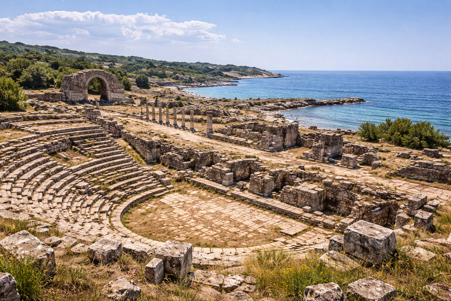
| المسرح | القرن الثالث ق.م | السعة نحو 5,000 متفرّج | مبني في سفح التلّ متّجهًا جنوبًا نحو لِسبوس |
| الأغورا | القرن الثاني ق.م | مستطيلة؛ محاطة بالأروقة | الستوا الشمالية والستوا الجنوبية تحفّان بفضاء مفتوح مركزي |
| الجمنازيوم | القرن الثاني ق.م | مجمّع بالستارا كبير | طريق مرصوف من البوّابة الرئيسية يقود إلى الجمنازيوم |
| البولوتيريون | القرن الثاني ق.م | بجوار الأغورا | قاعة المجلس للتجمّع المدني |
| المرفأ | مراحل متعدّدة | حوضا مرفأ من صنع الإنسان | المرفأ الجيد الوحيد على مدى 80 km من ساحل ترواد |
| أسوار المدينة | القرن الرابع ق.م (المرحلة الرئيسية) | مدار نحو 3 km؛ ارتفاع يصل إلى 14 m في أماكن | من بين أفضل أنظمة التحصين الهلنستية الحفظًا في ترواد |
| المقابر | من الأركية حتى الرومانية | شرق الجدار الدفاعي | توابيت "آكلة اللحم" (lapis sarcophagus) وصفها بلينيوس |
أرسطو في أسوس (347–344 ق.م)
تحتلّ أسوس مكانة فريدة في تاريخ الفلسفة كموقع أسّس فيه أرسطو أوّل مدرسته المستقلّة قبل تأسيس الليسيوم في أثينا.
- تاريخ الإقامة: 347–344 ق.م (ثلاث سنوات)
- الدعوة: هيرمياس، طاغية أتارنيوس وأسوس، دعا أرسطو وفلاسفة آخرين لتأسيس مدرسة
- الأنشطة: أجرى أرسطو ملاحظات بيولوجية وحيوانية رائدة على طول ساحل أسوس وفي خليج أدراميتيون، دراسات أثّرت لاحقًا على أعماله التأسيسية في التاريخ الطبيعي
- الزواج: تزوّج أرسطو من بيثياس، ابنة أخ هيرمياس (أو ابنته بالتبنّي)، خلال إقامته في أسوس
- المغادرة: غادر أرسطو أسوس إلى لِسبوس (حيث واصل أبحاثه البيولوجية مع ثيوفراستوس) وعاد في النهاية إلى مقدونيا لتعليم الإسكندر الأكبر الشاب
استمرّت المدرسة الفلسفية في أسوس بعد رحيل أرسطو تحت إدارة معاونيه، ممّا جعل أسوس عقدة مهمّة في نقل الفلسفة المشّائية عبر شرق المتوسط.
توابيت أسوس وأصل كلمة "تابوت حجري" (sarcophagus)
مقبرة أسوس هي الأصل الاشتقاقي لكلمة sarcophagus (تابوت حجري) نفسها. يذكر بلينيوس الأكبر (التاريخ الطبيعي 36.27) أنّ حجر الأنديزيت المحلّي كان له خاصّية استهلاك لحم الجثث الموضوعة فيه خلال 40 يومًا، ممّا أكسبه اسم lapis sarcophagus ("الحجر آكل اللحم"، من اليونانية sarx = لحم + phagein = يأكل).
| السمة | التفصيل |
|---|---|
| نوع الحجر | أنديزيت محلّي (طُف بركاني) |
| الخاصّية المُبلَّغ عنها | يحلّل اللحم خلال 40 يومًا (وفقًا لبلينيوس) |
| التفسير العلمي | على الأرجح بسبب محتوى الحجر العالي من أكسيد الكالسيوم ومساميته، اللذين سرّعا التحلّل |
| موقع المقابر | شرق الجدار الدفاعي الرئيسي، على طول طريق الاقتراب |
| أنواع القبور الموجودة | حجرات منحوتة في الصخر، توابيت مستقلّة (كثير منها غير مكتمل)، نُصب جنائزية مبنية |
| النطاق الزمني | من الفترة الأركية حتى الرومانية |
يجعل هذا الإرث الاشتقاقي أسوس واحدة من المدن القديمة القليلة جدًا التي اسمها مغروس في كلمة إنجليزية حديثة شائعة تُستخدم عالميًا.
المصادر
- https://en.wikipedia.org/wiki/Assos
- https://whc.unesco.org/en/tentativelists/6242/
- https://www.historyhit.com/locations/assos/
- https://www.tuerkei-antik.de/Tempel/assos_en.htm
- https://www.assosalarga.com/temple-of-athena-in-assos
- https://www.airial.travel/attractions/t%C3%BCrkiye/behram/temple-of-athena-assos-qSl4FOMC
- https://www.assosrehberim.com/en/nm-Assos_Ancient_City-cp-100
- https://de.wikipedia.org/wiki/Assos
غوص تاريخي موسّع
1) منطق المشهد التأسيسي
- لماذا اختير هذا الموقع في العصور القديمة.
- عوامل الماء والدفاع والطريق والزراعة.
- المخاطر الموسمية وكيف تكيّف المخطّطون القدماء.
2) مورفولوجيا الاستيطان عبر الفترات
- منطقة النواة المبكّرة ونمط التوسّع.
- التوزيع المعماري العامّ مقابل الخاصّ.
- كيف شكّل الارتفاع التنظيم الاجتماعي.
3) الحكم وعرض السلطة
- العمارة الضخمة كرسائل سياسية.
- الفضاءات الإدارية والشرعية العامّة.
- هوية المدينة تحت الإمبراطوريات المتغيّرة.
4) الجغرافيا الطقسية والرمزية
- الطبوغرافيا المقدّسة والهوية المدنية.
- الطرق الاستعراضية والحركة الاحتفالية.
- إعادة استخدام الفضاء الطقسي في الفترات اللاحقة.
5) الاقتصاد وأنظمة التجارة
- تنظيم السوق الداخلي.
- ممرّات التجارة الخارجية واللوجستيات.
- التخزين، وإعادة التوزيع، وإدارة الفائض.
6) إنتاج الحرف والثقافة المادية
- العمل بالحجر، والخزف، وأدلّة الورش.
- التوحيد القياسي مقابل التنوّع المحلي في الاكتشافات.
- مناطق الإنتاج وتبعات العمل.
7) ذكاء البنية التحتية
- جمع الماء وتخزينه وتوزيعه.
- الأنظمة الدفاعية والتحكّم في الطرق.
- عبء الصيانة والمرونة الحضرية.
8) الحياة الاجتماعية في الفضاء العامّ
- الأسواق والاجتماعات ومناطق الأداء.
- سلوك الحشد والطقوس المدنية.
- الحركة اليومية عبر المدينة.
9) الأزمة والدمار والتعافي
- إشارات الحريق والحرب والزلزال والهجر.
- استراتيجيات إعادة البناء وأنماط الاستمرارية.
- الذاكرة الثقافية بعد الاضطراب الكبير.
10) ملاحظات منهج علم الآثار
- التفكير الطبقي وتحذيرات التأريخ.
- لماذا يتغيّر التفسير عبر الزمن.
- الفرق بين البيانات المُثبتة والفرضية السردية.
جولة متخصّصة للزائر (مسار طويل)
- منطقة التوجّه وقراءة طبوغرافية.
- المحيط الدفاعي ومنطق البوّابة.
- تفسير المعلَم المميِّز.
- العمارة العامّة الثانوية والوظيفة المدنية.
- مناطق سكنية أو ورش لقراءة الحياة اليومية.
- نقاط ملاحظة الماء والبنية التحتية.
- تقييم الطبقة الطقسية/الرمزية.
- نقطة منظر نهائية لتوليف المدينة-المشهد.
للمجموعات التعليمية، توقّف كلّ 10–15 دقيقة لتفسير دقيق.
استراتيجية ميدانية أوّلًا في الشتاء والفصول الانتقالية
- يقدّم الشتاء غالبًا خطوط حركة أنظف وضغط حشد أقلّ.
- يمكن أن تؤثّر الرطوبة والرياح على سلامة الموقع وإيقاع الحركة.
- حافظ على مرونة المسار في حالة حدوث إغلاقات جزئية.
- أعطِ الأولوية لعمق التفسير على المسافة.
قائمة الشتاء الموصى بها:
- مسار مؤكّد بالطقس،
- ملابس متعدّدة الطبقات،
- أحذية مقاومة للماء،
- احتياطي وقت إضافي،
- خطة خروج واعية بضوء النهار.
أسئلة بحثية عملية للقرّاء المتقدّمين
- أيّ طبقة معمارية تهيمن على الرؤية الحالية؟
- أيّ مرحلة ممثّلة تمثيلًا ناقصًا بسبب تحيّز الحفظ؟
- ماذا يكشف محاذاة الطريق عن السلطة والاقتصاد؟
- هل المراكز المقدّسة والإدارية متكاملة مكانيًا؟
- كيف تتعامل المدينة مع الطبوغرافيا والرؤية؟
أسئلة شائعة موسّعة
كيف يجب أن أُعطي الأولوية للمناطق إذا كان لديّ ساعتان فقط؟
ركّز على نقطة توجّه واحدة، ومعلَم رئيسي واحد، ومنطقة حياة يومية واحدة، ومحطّة توليف مشهد طبيعي واحدة.
هل هذا الموقع أفضل كزيارة مستقلّة أم كجزء من مسار؟
عادة أفضل كجزء من مسار، لأنّ السياق المقارن يحسّن الفهم.
لماذا تبدو بعض الأطلال مُجَزَّأة بينما أخرى ضخمة؟
ظروف الحفظ، وإعادة الاستخدام اللاحقة، وتاريخ التنقيب، ومتانة المواد تخلق بقاءً غير متساوٍ.
هل يمكن لغير المتخصّصين أن يحظوا بتجربة عالية الجودة؟
نعم — إذا اتّبعوا مسارًا منظّمًا واستخدموا إشارات التسلسل الزمني.
ما هو خطأ التفسير الرئيسي؟
افتراض أنّ جميع البقايا المرئية تنتمي إلى تاريخ واحد أو فترة سياسية واحدة.
إطار القراءة: 12 زاوية
- الطبوغرافيا
- الدفاع
- الماء
- الحركة
- الطقوس
- الإدارة
- الاقتصاد
- السكن
- الإنتاج
- الذاكرة
- الحفظ
- أخلاقيات الزائر
طبّق هذا الإطار قسمًا بقسم لتحويل المشاهدة السلبية إلى قراءة تاريخية نشطة.
السلوك المسؤول تجاه التراث
- ابقَ على المسارات المعلَّمة حيث يلزم.
- تجنّب لمس الأسطح الهشّة.
- لا تتسلّق البناء غير المستقرّ.
- احترم حدود التنقيب.
- استخدم التصوير بمسؤولية.
ينجو التراث الثقافي عبر اختيارات صغيرة تراكمية من قبل الزوّار.