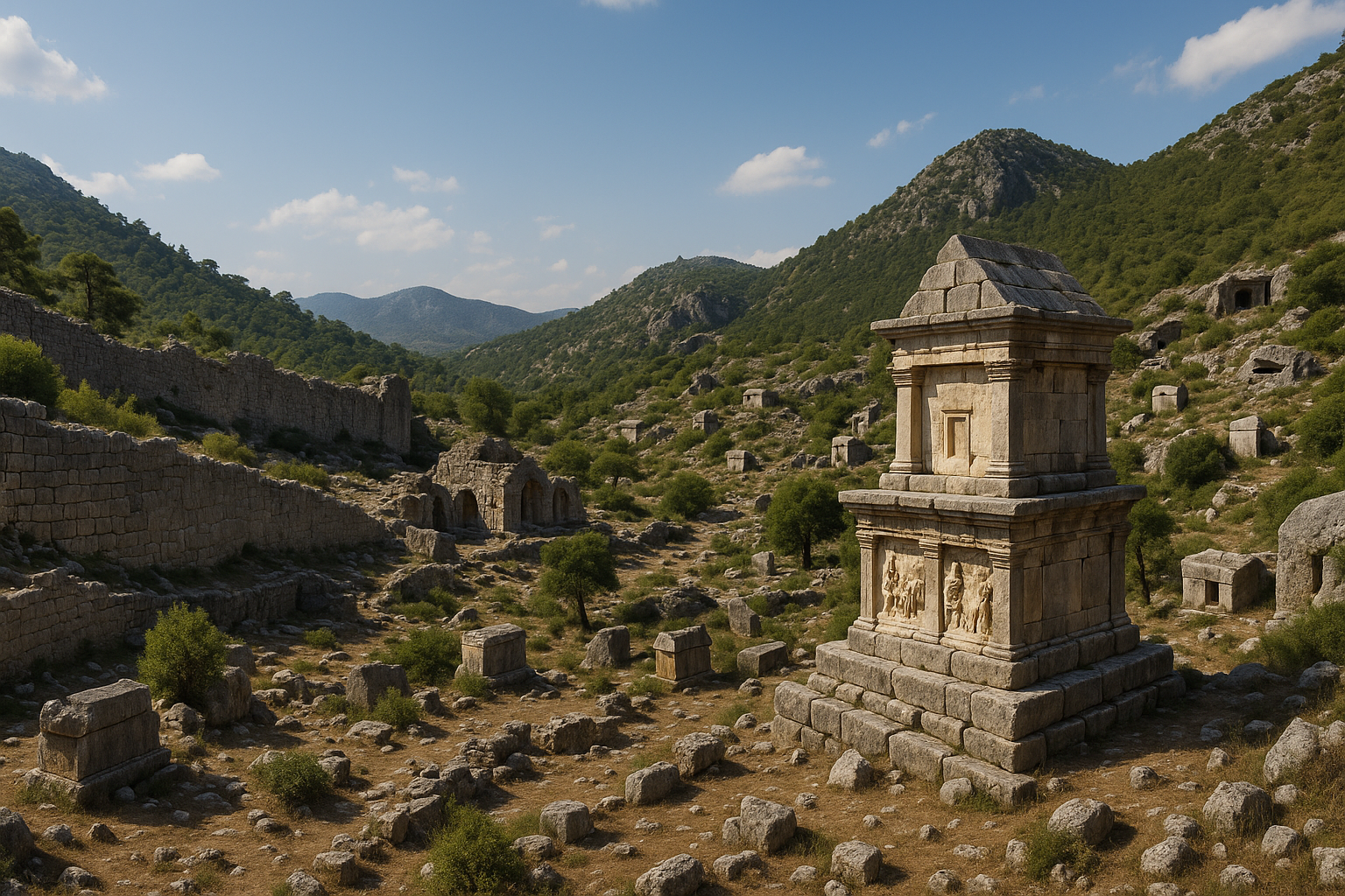
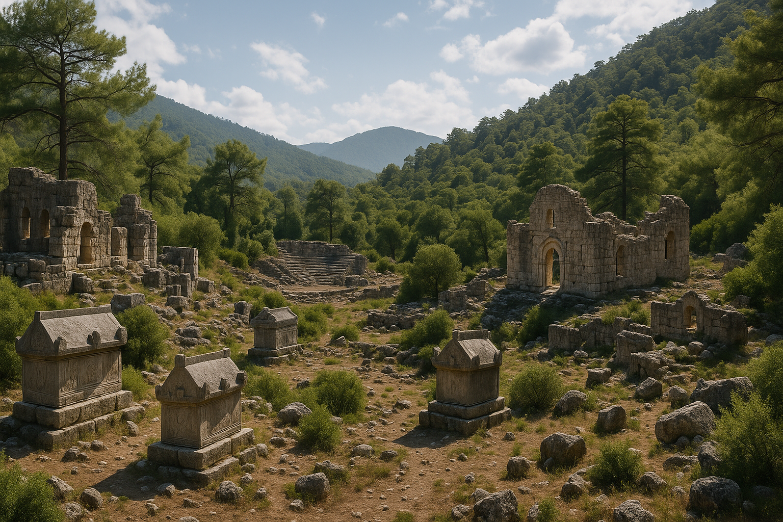
Krótkie podsumowanie: Phaselis to jedno z najważniejszych nadmorskich miast archeologicznych w Turcji, łączące w sobie archeologię portową, pozostałości rzymskiej urbanistyki i wyjątkowe walory krajobrazowe Morza Śródziemnego. Założone przez kolonistów rodyjskich, a następnie włączone w orbity świata licyjskiego, hellenistycznego, rzymskiego i bizantyjskiego, Phaselis słynie przede wszystkim z trzech naturalnych portów, kolumnowej osi miejskiej, teatru, pozostałości akweduktu oraz strefy monumentalnej bramy.
Spis treści
- Dlaczego to miejsce jest ważne
- Tło historyczne i oś czasu
- Przewodnik po czytaniu stanowiska archeologicznego
- Jak lepiej doświadczyć tego miejsca
- Wskazówki turystyczne według pór roku (w tym zima)
- Narracyjne spojrzenie dla odwiedzających
- FAQ
- Źródła
Dlaczego to miejsce jest ważne
Phaselis to jedno z najważniejszych nadmorskich miast archeologicznych w Turcji, łączące w sobie archeologię portową, pozostałości rzymskiej urbanistyki i wyjątkowe walory krajobrazowe Morza Śródziemnego. Założone przez kolonistów rodyjskich, a następnie włączone w orbity świata licyjskiego, hellenistycznego, rzymskiego i bizantyjskiego, Phaselis słynie przede wszystkim z trzech naturalnych portów, kolumnowej osi miejskiej, teatru, pozostałości akweduktu oraz strefy monumentalnej bramy.
To miejsce jest nie tylko celem archeologicznym, lecz długotrwałym świadectwem kulturowym. Pomaga odwiedzającym zrozumieć, jak z biegiem czasu zmieniało się życie miejskie, handel, systemy wierzeń i władza polityczna w Anatolii.
Tło historyczne i oś czasu
Aby historycznie odczytać to stanowisko, myśl warstwami, a nie pojedynczą datą: okres założenia, faza ekspansji, transformacja pod rządami nowych mocarstw oraz „życie po życiu" w pamięci późnoantycznej i średniowiecznej.
Przewodnik po czytaniu stanowiska archeologicznego
Zwiedzając stanowisko, stosuj następującą kolejność:
- Punkt orientacyjny – rozpoznaj topografię i strategiczne położenie.
- Pomnik charakterystyczny – teatr, świątynia, akropol, brama lub kompleks portowy.
- Warstwa życia codziennego – ulice, warsztaty, łaźnie, magazyny, systemy wodne.
- Relacja z krajobrazem – zrozum, dlaczego to miasto powstało właśnie w tym miejscu.
Ta metoda zamienia krótki spacer w wizytę interpretacyjną.
Jak lepiej doświadczyć tego miejsca
- Zaplanuj wystarczającą ilość czasu (minimum 2 godziny na sensowne zwiedzanie).
- Zapoznaj się z kontekstem przed przybyciem, a następnie zweryfikuj go przy ruinach.
- Potraktuj stanowisko jako punkt węzłowy trasy, a nie przystanek na jedno zdjęcie.
- Łącz obserwację architektury z obserwacją krajobrazu, aby uzyskać pełną interpretację.
Wskazówki turystyczne według pór roku (w tym zima)
- Wiosna / Jesień: zazwyczaj najlepsze warunki komfortu i spacerów.
- Lato: wyruszaj wcześnie; południowy upał może obniżyć jakość przeżyć.
- Zima: często spokojniejsza i lepsza do powolnego „czytania" stanowiska; sprawdź wcześniej prognozę deszczu/wiatru i zmiany godzin otwarcia.
Narracyjne spojrzenie dla odwiedzających
Wyobraź sobie, że przybywasz tu wieki temu o świcie: ruch przy bramach lub portach, głosy z przestrzeni targowych, aktywność rytualna w strefach sakralnych i życie administracyjne w budynkach publicznych. Widoczne dziś pozostałości to fragmenty tamtych powtarzających się codziennych wzorców.
FAQ
Co sprawia, że Starożytne Miasto Phaselis – Kemer, Antalya jest szczególnie ważne?
Jego znaczenie wynika z ciągłości historycznej, widoczności archeologicznej i regionalnego oddziaływania kulturowego.
Ile czasu powinienem przeznaczyć?
Większość odwiedzających potrzebuje 2–3 godzin; pogłębione zwiedzanie może zająć pół dnia.
Czy to miejsce nadaje się dla początkujących podróżników archeologicznych?
Tak. Stanowisko może cieszyć nowicjuszy, jeśli odwiedzane jest z jasno zaplanowaną trasą.
Czy zima to zły czas na wizytę?
Niekoniecznie. Zima może być doskonałym czasem na eksplorację przy małym tłumie, jeśli pogoda jest odpowiednia.
Co powinienem priorytetyzować, gdy mam mało czasu?
Pomnik charakterystyczny, jedną strefę życia codziennego i jeden mocny punkt widokowy na krajobraz.
Pomiary architektoniczne i dane inżynieryjne
Phaselis zachowała mierzalną infrastrukturę z epoki rzymskiej, która ujawnia skalę i ambicje planowania urbanistycznego.
Główna ulica kolumnowa
| Parametr | Pomiar |
|---|---|
| Całkowita długość | 225 m (od centralnego portu do Bramy Hadriana) |
| Szerokość | 20–24 m łącznie z kolumnadami |
| Nawierzchnia | Wyłożona kamiennymi i marmurowymi płytami |
| Data | Sklepy i portyki przeważnie z II w. p.n.e.; nawierzchnia odnowiona w okresie cesarstwa rzymskiego |
| Funkcja | Służyła jednocześnie jako aleja handlowa, droga procesyjna i nieformalny stadion |
Posągi dobroczyńców obywatelskich i postaci cesarskich niegdyś zdobiły obie strony kolumnady. Ulica kończyła się od południa monumentalnym kompleksem Bramy Hadriana.
Brama Hadriana (131 n.e.)
Łuk triumfalny został wzniesiony w 131 n.e. dla upamiętnienia wizyty cesarza Hadriana w Phaselis. Inskrypcja dedykacyjna wyrzeźbiona w trzech liniach na architrawie czci Hadriana jako „zbawiciela i dobroczyńcę" miasta. Towarzyszące inskrypcje w pobliżu poświęcone były żonie Hadriana Sabinie oraz jego teściowej Matidii, co świadczy o bezpośrednim zaangażowaniu rodziny cesarskiej w sprawy miasta.
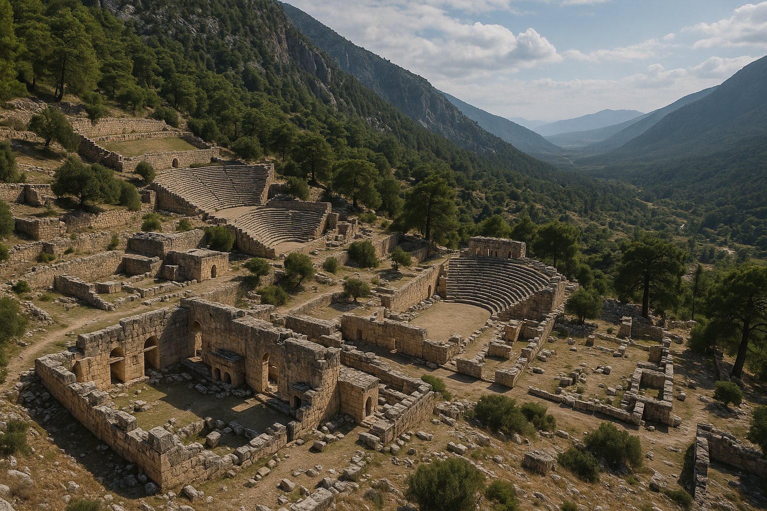
Teatr
| Parametr | Pomiar |
|---|---|
| Średnica kawea | 46–50 m |
| Średnica orchestry | 16–17 m |
| Rzędy siedzeń | 20–21 rzędów podzielonych na 5 cunei |
| Szacunkowa pojemność | 1 500–2 000 widzów |
| Data budowy | II wiek n.e. |
| Orientacja | Zwrócony na północny wschód, ku centralnemu portowi |
Teatr zbudowany jest na zboczu wzgórza akropolowego, a nie na w pełni sztucznym podgruncie – technika typowa dla projektowania w tradycji hellenistycznej, zaadaptowana na potrzeby użytkowania rzymskiego.
Akwedukt
Rzymski akwedukt biegnie około 450 m wzdłuż zatoki w pobliżu północnego portu i jest jedną z najlepiej zachowanych konstrukcji hydraulicznych na stanowisku. Dostarczał wodę ze źródeł na górskich zboczach do cystern i publicznych nymfeonów w mieście.
Obrona łańcuchem portowym
Drugi (wojskowy) port był otoczony murem morskim i mógł być blokowany łańcuchem o długości 18 m rozpiętym między dwiema flankującymi wieżami – mechanizm obronny analogiczny do Złotego Rogu w Konstantynopolu i innych ufortyfikowanych portów wschodniego Morza Śródziemnego.
Dowody numizmatyczne
Phaselis biła własną monetę od V wieku p.n.e. Seria monet stanowi ciągły zapis politycznych powiązań miasta i jego żywotności ekonomicznej.
| Okres | Typ monety | Awers | Rewers | Standard wagowy |
|---|---|---|---|---|
| V wiek p.n.e. | Srebrny trihemiobol | Dziób galery (phaselus) | Rufa galery | Rodyjski |
| IV wiek p.n.e. | Srebrny stater | Dziób z apotropaicznym akrostolionem i delfinem | Rufa galery | Rodyjski |
| 167–130 p.n.e. | AR stater (Liga Licyjska) | Atena Promachos na dziobie | Stojący Apollo; 26 mm, 10,71 g | Standard Ligi Licyjskiej |
| Okres cesarstwa rzymskiego | Brąz | Portret panującego cesarza | Atena Polias lub dziób galery | Prowincjonalny rzymski |
Motyw dziobu galery pełni funkcję herbu mówiącego (type parlant): greckie słowo phaselus oznacza „małą łódź", przez co wizerunek statku jest wizualnym kalambur na nazwę miasta. Ta morska identyfikacja utrzymywała się przez prawie wszystkie okresy mennictwa Phaselis.
Kult Ateny Polias, przywieziony z miasta-matki Lindos na Rodos przy założeniu (ok. 691/690 p.n.e. przez przywódcę kolonistów Lakiosa), pojawia się wielokrotnie na późniejszych monetach, potwierdzając trwałość rodyjskiej tożsamości religijnej przez ponad siedem stuleci.
Chronologia wykopalisk
| Rok / Okres | Kierownik / Zespół | Przedmiot badań |
|---|---|---|
| 1811 | Kapitan Francis Beaufort (Królewska Marynarka Wojenna) | Pierwsze nowoczesne rozpoznanie i kartografia wybrzeża |
| lata 60.–70. XX w. | Tureckie Ministerstwo Kultury | Wstępne rozpoznanie i konserwacja |
| 1981–2001 | Prof. Cevdet Bayburtluoglu (Uniwersytet Ankarski) | Systematyczne wykopaliska portów, głównej ulicy, łaźni, agory, teatru |
| 2012–obecnie | Doç. dr Murat Arslan (Uniwersytet Akdeniz) | Wznowiony program wykopalisk i publikacji |
Stanowisko zajmuje około 30 hektarów w obrębie Nadmorskiego Parku Narodowego Olimpos-Beydagları. Kolumnowa ulica główna, dwa kompleksy łaźni (oba z III w. n.e., z ogrzewaniem hypocaustowym), łaźnia-gimnazjon z zachowanymi fragmentami mozaik po zachodniej stronie głównej ulicy oraz trzy porty tworzą główne przebadane strefy. Znaczna część tkanki mieszkalnej oraz szczyt akropolu pozostają jedynie częściowo zbadane.
Źródła
- https://en.wikipedia.org/wiki/Phaselis
- https://upload.wikimedia.org/wikipedia/commons/5/54/Phaselis_Aqueduct_5267.jpg
- https://upload.wikimedia.org/wikipedia/commons/2/26/Phaselis_City_Harbour_5300.jpg
- https://upload.wikimedia.org/wikipedia/commons/d/d7/Phaselis_Hadrian%27s_Gate_5314.jpg
- https://upload.wikimedia.org/wikipedia/commons/5/58/Phaselis_Domitian_Agora_5328.jpg
- https://upload.wikimedia.org/wikipedia/commons/2/21/Phaselis_Big_Bath_5284.jpg
- https://tr.wikipedia.org/wiki/Phaselis
- https://commons.wikimedia.org/w/index.php?search=Phaselis+Ancient+City+–+Kemer,+Antalya&title=Special:MediaSearch&type=image
Rozszerzone historyczne zagłębienie
1) Logika krajobrazowa założenia
- Dlaczego to miejsce zostało wybrane w starożytności.
- Czynniki wodne, obronne, szlakowe i rolnicze.
- Sezonowe zagrożenia i sposoby adaptacji przez starożytnych planistów.
2) Morfologia osadnictwa w różnych okresach
- Wczesna strefa rdzeniowa i wzorzec ekspansji.
- Rozkład architektury publicznej i prywatnej.
- Wpływ wysokości terenu na organizację społeczną.
3) Zarządzanie i demonstracja władzy
- Architektura monumentalna jako przesłanie polityczne.
- Przestrzenie administracyjne i legitymizacja publiczna.
- Tożsamość miasta pod kolejnymi imperiami.
4) Rytualna i symboliczna geografia
- Sakralna topografia i tożsamość obywatelska.
- Trasy procesjonalne i ceremonialne przemieszczanie się.
- Ponowne wykorzystanie przestrzeni rytualnej w późniejszych okresach.
5) Gospodarka i systemy handlowe
- Wewnętrzna organizacja rynku.
- Zewnętrzne korytarze handlowe i logistyka.
- Magazynowanie, redystrybucja i zarządzanie nadwyżkami.
6) Produkcja rzemieślnicza i kultura materialna
- Kamieniarstwo, ceramika i ślady warsztatów.
- Standaryzacja kontra lokalna odmienność w znaleziskach.
- Strefy produkcji i implikacje dotyczące siły roboczej.
7) Inteligencja infrastrukturalna
- Zbieranie, magazynowanie i dystrybucja wody.
- Systemy obronne i kontrola szlaków.
- Ciężar konserwacji i odporność urbanistyczna.
8) Życie społeczne w przestrzeni publicznej
- Targi, zgromadzenia i miejsca widowisk.
- Zachowania tłumu i rytuały obywatelskie.
- Codzienne przemieszczanie się po mieście.
9) Kryzys, zniszczenie i odbudowa
- Sygnały pożarów, działań wojennych, trzęsień ziemi i opuszczenia.
- Strategie odbudowy i wzorce ciągłości.
- Pamięć kulturowa po poważnych zakłóceniach.
10) Uwagi dotyczące metod archeologicznych
- Wnioskowanie stratygraficzne i ostrożność w datowaniu.
- Dlaczego interpretacja zmienia się w czasie.
- Różnica między udokumentowanymi danymi a hipotezą narracyjną.
Szczegółowy przewodnik dla specjalistycznych odwiedzających (trasa długa)
- Strefa orientacyjna i lektura topograficzna.
- Obwód obronny i logika bramy.
- Interpretacja pomnika charakterystycznego.
- Wtórna architektura publiczna i funkcja obywatelska.
- Obszary mieszkalne lub warsztatowe jako odczyt życia codziennego.
- Punkty obserwacyjne wody i infrastruktury.
- Ocena warstwy rytualnej/symbolicznej.
- Końcowy punkt widokowy dla syntezy miasto–krajobraz.
Dla grup edukacyjnych – przerwa co 10–15 minut na mikro-interpretację.
Strategia terenowa na zimę i sezon pośredni
- Zima często oferuje czystsze linie przemieszczania się i mniejszy tłok.
- Wilgoć i wiatr mogą wpływać na bezpieczeństwo i tempo zwiedzania.
- Zachowaj elastyczność trasy w przypadku częściowych zamknięć.
- Priorytetem jest głębokość interpretacji, a nie pokonany dystans.
Zalecana zimowa lista kontrolna:
- trasa potwierdzona pogodowo,
- warstwowe ubranie,
- wodoodporne obuwie,
- zapasowy bufor czasowy,
- plan wyjścia uwzględniający długość dnia.
Praktyczne pytania badawcze dla zaawansowanych czytelników
- Która warstwa architektoniczna dominuje w aktualnej widoczności?
- Która faza jest niedoreprezentowana z powodu uprzedzeń konserwatorskich?
- Co układ dróg ujawnia o władzy i gospodarce?
- Czy centra sakralne i administracyjne są przestrzennie zintegrowane?
- Jak miasto negocjuje topografię i widoczność?
Rozszerzone FAQ
Jak powinienem priorytetyzować obszary, jeśli mam tylko dwie godziny?
Skup się na jednym punkcie orientacyjnym, jednym głównym pomniku, jednej strefie życia codziennego i jednym przystanku syntezy krajobrazowej.
Czy to stanowisko lepiej odwiedzić samodzielnie czy jako część trasy?
Zazwyczaj lepiej jako część trasy, ponieważ kontekst porównawczy poprawia zrozumienie.
Dlaczego niektóre ruiny wyglądają fragmentarycznie, podczas gdy inne są monumentalne?
Warunki konserwatorskie, późniejsze ponowne wykorzystanie, historia wykopalisk i trwałość materiałów tworzą nierówne przeżycie.
Czy niespecjaliści mogą nadal mieć wysokiej jakości doświadczenie?
Tak – jeśli podążają ustrukturyzowaną trasą i korzystają z wskazówek chronologicznych.
Jaki jest główny błąd interpretacyjny?
Zakładanie, że wszystkie widoczne pozostałości należą do jednej daty lub jednego okresu politycznego.
Schemat lektury: 12 perspektyw
- Topografia
- Obrona
- Woda
- Ruch
- Rytuał
- Administracja
- Gospodarka
- Mieszkalnictwo
- Produkcja
- Pamięć
- Konserwacja
- Etyka odwiedzającego
Stosuj ten schemat sekcja po sekcji, aby przekształcić bierne zwiedzanie w aktywną lekturę historyczną.
Odpowiedzialne zachowanie wobec dziedzictwa
- Pozostawaj na wyznaczonych ścieżkach tam, gdzie jest to wymagane.
- Unikaj dotykania delikatnych powierzchni.
- Nie wspinaj się na niestabilne mury.
- Szanuj granice wykopalisk.
- Fotografuj odpowiedzialnie.
Dziedzictwo kulturowe przetrwa dzięki skumulowanym drobnym wyborom odwiedzających.