Cyzicus (Greek: Kyzikos) was one of the greatest cities of the ancient world, strategically located on the narrow isthmus connecting the Kapidagi (Arktonnesos) Peninsula to the Anatolian mainland, near the modern town of Erdek in Balikesir province. Founded around 680 BC as a Milesian colony on the southern shore of the Propontis (Sea of Marmara), Cyzicus rose to become a naval powerhouse, an international banking center whose electrum coins circulated throughout the Mediterranean, and the home of the Temple of Hadrian -- ranked among the three largest temples of the Roman Empire, with column capitals measuring 1.9 meters in diameter, the largest ever found. Despite devastating earthquakes and centuries of stone-robbing, the surviving ruins still convey the monumental ambition of a city that ancient authors compared to Ephesus and Pergamon. The site is under active excavation as part of Turkey's "Heritage for the Future" project, and has been proposed for UNESCO World Heritage nomination.
- Why Cyzicus Matters
- Geography and Setting
- Historical Timeline
- Major Monuments and Finds
- The Electrum Coinage of Cyzicus
- Archaeological Work
- Visitor Information
- Frequently Asked Questions
- Sources and Further Reading
Why Cyzicus Matters
-
International currency of the ancient world. From the 6th century BC onward, Cyzicus minted electrum staters (a gold-silver alloy) known as "Kyzikenes," which became one of the most widely accepted trade currencies in the Aegean and Black Sea regions. The tunny fish emblem on these coins became the city's trademark, and Cyzicene staters were used as a standard for Black Sea grain trade for centuries. Over 200 distinct obverse types have been catalogued, making them one of the most artistically varied coin series of antiquity.
-
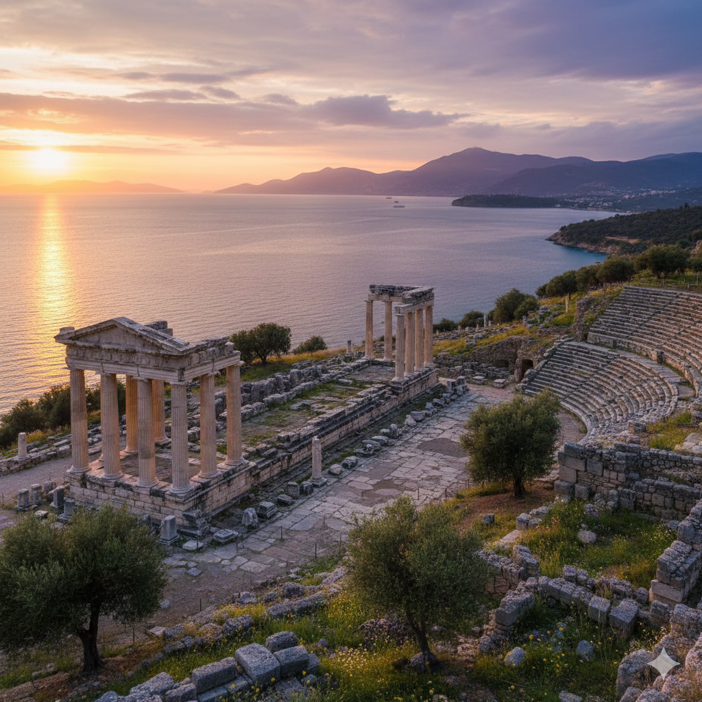
Home to one of the largest temples ever built. The Temple of Hadrian (Hadrianeion), constructed in the 2nd century AD, was described by ancient sources as rivaling the great temples of Ephesus and Baalbek. Excavations have uncovered a Corinthian column capital 1.9 meters in diameter -- confirmed as the largest temple column capital ever found in the Roman Empire. The columns stood 21.35 meters tall, making them the highest known from the Roman world.
-
Pivotal battlefield of the Peloponnesian War. The Battle of Cyzicus (410 BC) was a turning point in the war between Athens and Sparta. The Athenian commander Alcibiades decisively defeated the Spartan fleet here, temporarily restoring Athenian control of the vital grain route from the Black Sea.
-
Connected to the Argonaut legend. In Greek mythology, Cyzicus was the city of King Cyzicus, who received Jason and the Argonauts hospitably during their voyage to Colchis. The tragic accidental killing of King Cyzicus by the Argonauts became one of the most poignant episodes of the Argonautica.
-
Active UNESCO candidacy. The scale and historical significance of the site have led to active discussions about nominating Cyzicus for UNESCO World Heritage inscription, recognizing it as one of the most important ancient urban sites on the Sea of Marmara. Excavations continue year-round under the Ministry of Culture and Tourism's "Heritage for the Future" program.
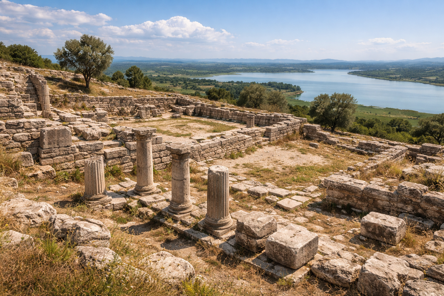
Geography and Setting
Cyzicus was built on the isthmus and southern slopes of the Kapidagi Peninsula (ancient Arktonnesos, meaning "Bear Island"), which juts northward into the Sea of Marmara. In antiquity, the peninsula was actually an island connected to the mainland by a narrow sand bar that gradually broadened into a permanent land bridge through natural silting and, according to ancient sources, deliberate engineering by Alexander the Great during his campaign in 334 BC.
Strategic Position
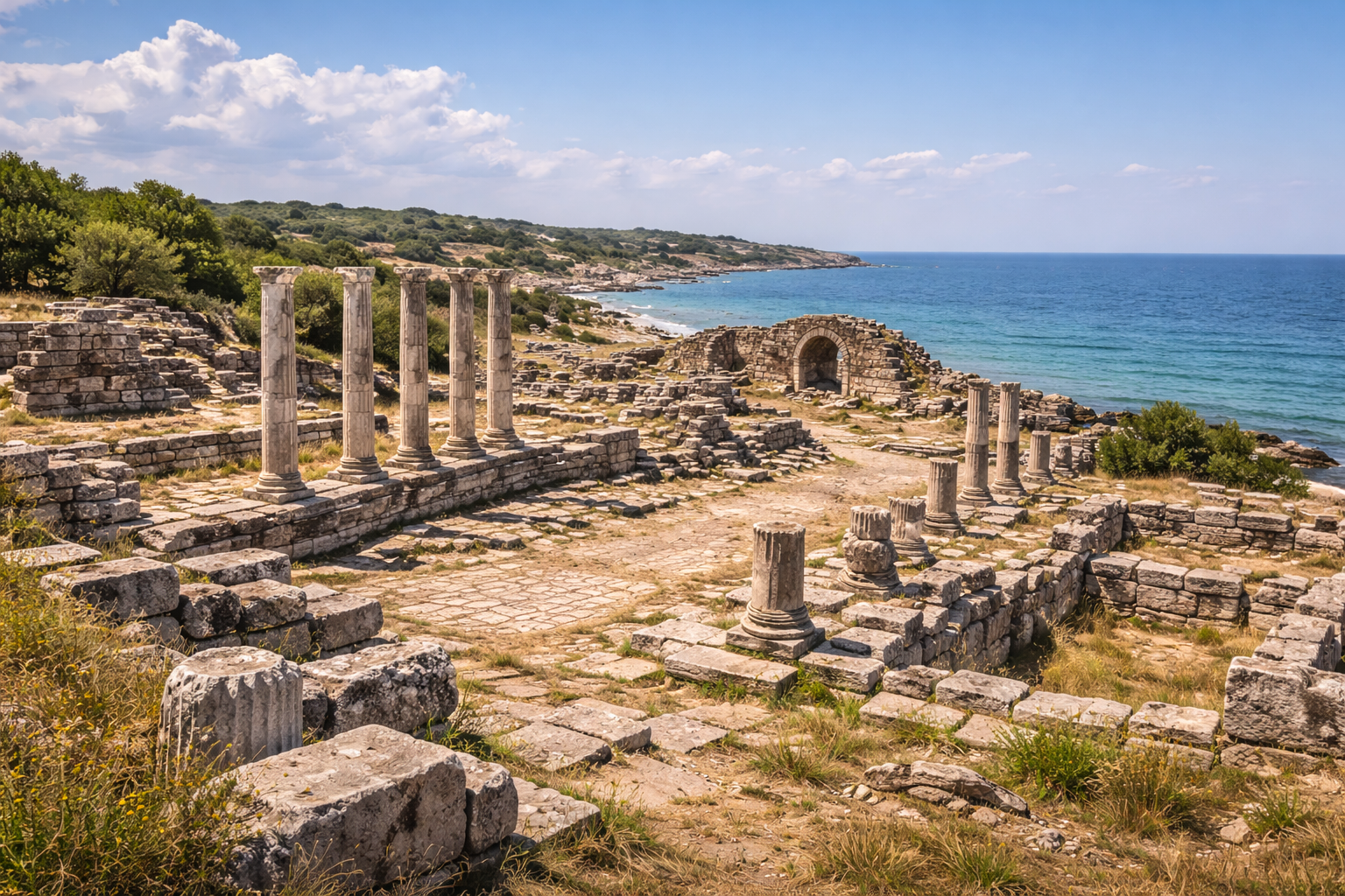
The city occupied a commanding position with two natural harbors -- one facing east and one facing west -- that allowed it to control maritime traffic along the southern Marmara coast. The eastern harbor opened toward the Bosphorus and Black Sea trade routes, while the western harbor connected to routes leading to the Hellespont (Dardanelles) and Aegean. This dual-harbor configuration gave Cyzicus unparalleled flexibility in accommodating ships regardless of wind direction.
The Kapidagi Peninsula
The peninsula itself is a mountainous landmass reaching approximately 800 meters elevation, with forests, olive groves, and fresh-water springs. The area around the ancient city, near modern Belkis and Erdek, features gently sloping terrain with panoramic views across the Marmara waters. The peninsula's protected bays and headlands provided additional anchorages and fishing grounds.
Agricultural and Maritime Wealth
The surrounding region includes the rich agricultural plains of the Bandirma hinterland and access to Lake Manyas (Kus Golu -- Bird Lake) to the south. This combination of protected harbors, agricultural productivity, and strategic position on major east-west sea lanes made Cyzicus one of the wealthiest cities in Anatolia for over a millennium. The tunny fish (tuna) that appears on the city's coins was not merely decorative -- it reflected the commercial importance of the local fisheries.
Marble Supply
The proximity of Marmara Island (Proconnesos) -- one of the most important marble-quarrying centers of the ancient world -- provided Cyzicus with easy access to high-quality white marble for its monumental buildings. The Proconnesian marble quarries supplied stone for buildings across the Roman Empire, including many structures in Constantinople.
Historical Timeline
Mythological Origins
Greek mythology places the founding of Cyzicus in the heroic age. According to the Argonautica of Apollonius of Rhodes, the Argonauts landed here on their voyage to Colchis and were received by King Cyzicus, a young ruler descended from the Thessalian Pelasgians. In a tragic episode, the Argonauts accidentally killed King Cyzicus when they returned to the harbor at night and were mistaken for raiders. The city was said to bear his name in memorial, and foundation rites commemorating the tragedy were performed annually.
Colonial Foundation (c. 680 BC)
The historical Cyzicus was founded around 680 BC by colonists from Miletus, the great Ionian city and prolific mother-city of dozens of colonies around the Black Sea and Marmara coasts. The Milesian settlers established the city on the isthmus, taking advantage of the double harbor and fertile hinterland. Archaeological evidence suggests possible earlier Greek or indigenous Anatolian settlement on the peninsula.
Archaic Period and Electrum Coinage (6th century BC)
From the mid-6th century BC, Cyzicus began producing its famous electrum staters, coins made from a naturally occurring gold-silver alloy. These coins featured an enormous variety of designs on the obverse -- over 200 known types depicting animals, mythological figures, and deities -- while the reverse consistently showed a simple square incuse punch. The tunny fish symbol appeared on most coins as a subsidiary mark identifying the mint.
Classical Period (5th--4th centuries BC)
During the Persian Wars, Cyzicus initially fell under Persian control as part of the satrapy of Hellespontine Phrygia. After the Greek victory, it became a member of the Delian League under Athenian leadership.
The most dramatic event was the Battle of Cyzicus in 410 BC, during the Peloponnesian War. The Athenian generals Alcibiades, Thrasybulus, and Theramenes combined their fleets and decisively defeated the Spartan navy commanded by Mindarus, who was killed in the battle. The captured Spartan dispatch read: "Ships lost. Mindarus dead. Men starving. Don't know what to do." This victory temporarily restored Athenian control of the Hellespont and Black Sea grain routes.
Hellenistic Period (334--1st century BC)
Alexander the Great passed through the region in 334 BC, and the connection of the peninsula to the mainland is sometimes attributed to engineering works during his campaign. Under the successor kingdoms, Cyzicus maintained its prosperity and was granted the status of a free city with autonomous governance.
In 74 BC, during the Third Mithridatic War, King Mithridates VI of Pontus besieged Cyzicus with an army reportedly numbering 300,000. The Roman general Lucullus lifted the siege by cutting Mithridatic supply lines, and the city's heroic resistance was celebrated for centuries afterward.
Roman Imperial Period (1st century BC--4th century AD)
Under Roman rule, Cyzicus flourished as never before. The city was designated the capital of the province of Mysia and granted the status of a free city (civitas libera) within the Roman province of Asia.
The crowning achievement of Roman Cyzicus was the Temple of Hadrian (Hadrianeion), constructed during the reigns of Hadrian (r. 117--138 AD) and Antoninus Pius (r. 138--161 AD). Ancient sources including Cyriacus of Ancona described it as one of the largest and most magnificent temples in the Roman world.
Cyzicus also served as one of the Roman imperial mints from the late 3rd century onward, producing coins for emperors from Diocletian through the 5th century. The mint mark "K" or "SMK" on late Roman coins identifies Cyzicus as their place of production.
Decline and Destruction (5th--11th centuries)
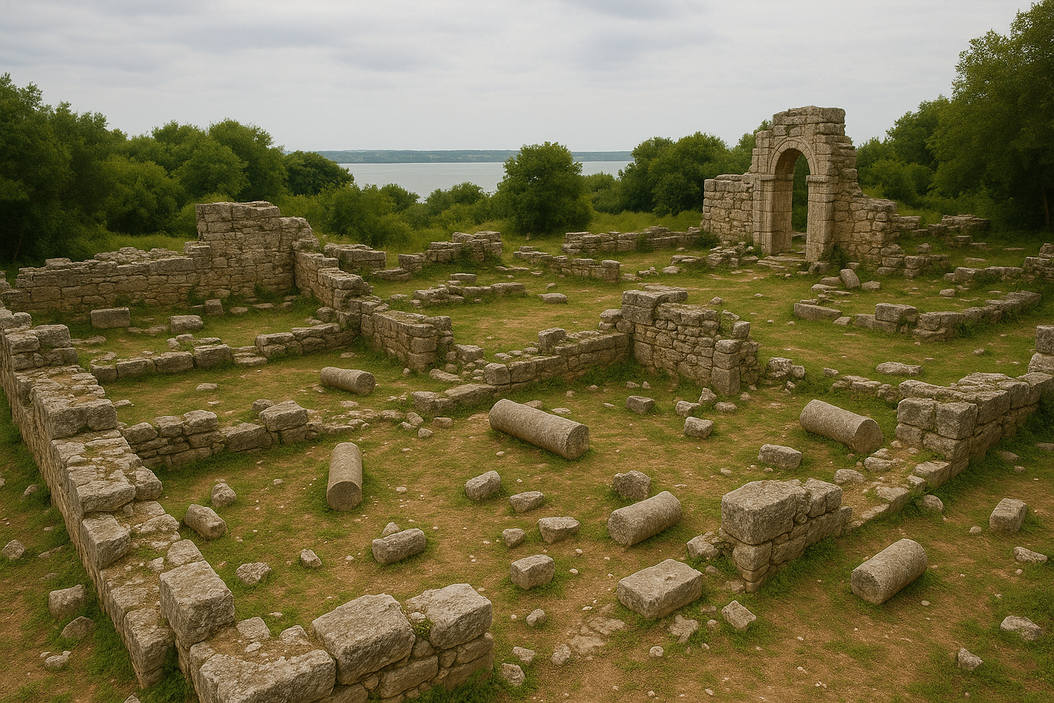
A series of catastrophic earthquakes -- particularly devastating ones in 443 AD and 675 AD -- progressively destroyed the monumental buildings of Cyzicus. The Temple of Hadrian collapsed, and the city's marble architecture was quarried for reuse in construction projects including reportedly in Constantinople (Istanbul). Arab raids in the 7th--8th centuries further damaged the city. By the 11th century, Cyzicus had been largely abandoned.
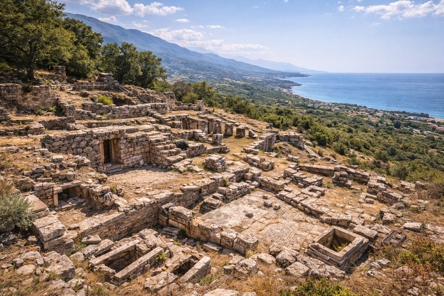
Major Monuments and Finds
The Temple of Hadrian (Hadrianeion)
The most famous monument, a colossal pseudodipteral Corinthian temple dedicated to the deified Emperor Hadrian:
- Plan: approximately 33 x 63 meters (8 x 15 columns)
- Column height: 21.35 meters -- the tallest known from any Roman temple
- Column capital diameter: 1.9 meters -- the largest Roman temple column capital ever discovered, confirmed by excavation
- Material: Proconnesian marble from nearby Marmara Island
- Construction period: approximately 120--160 AD under Hadrian and Antoninus Pius
- Recognition: Ranked among the top three temples of the 2nd-century Roman world, comparable to the Temple of Artemis at Ephesus and the Temple of Jupiter at Baalbek
The temple substructure, consisting of massive vaulted chambers, is the best-preserved portion. Scattered column drums, architrave blocks, and the famous oversized Corinthian capital are visible at the site. Archaeologists have been piecing together fallen architectural members to reconstruct the temple's original proportions and decorative program.
The City Walls
The 4th-century AD city walls are traceable for nearly their entire circuit, extending approximately 7 kilometers around the urban area. Built of cut stone with regular towers, the walls are among the best-preserved Late Roman urban fortifications in the Marmara region. Gates and defensive towers punctuate the circuit at regular intervals.
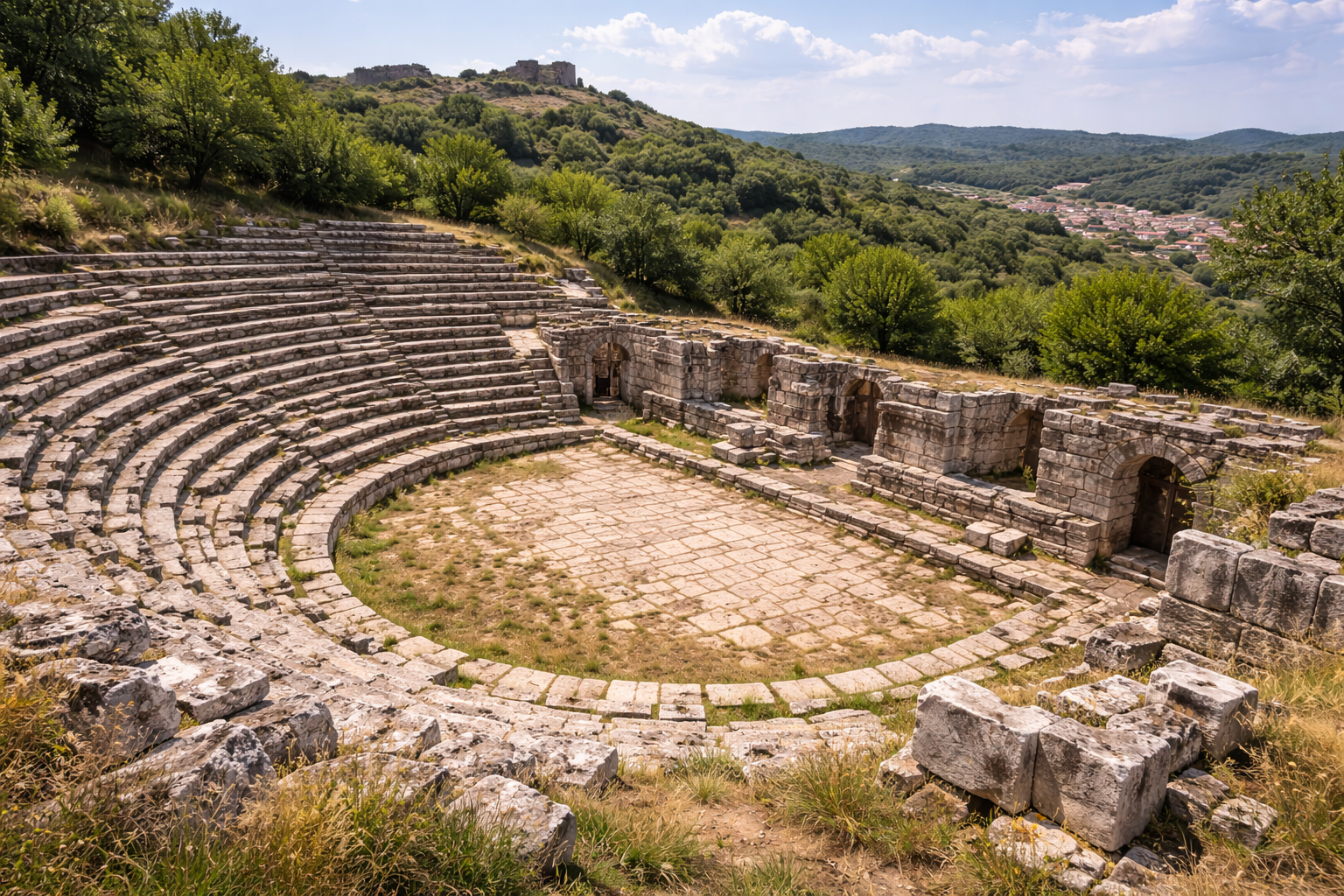
The Amphitheater
Cyzicus possessed one of the largest amphitheaters in the Roman East, with construction dating from the mid-1st to the late 3rd century AD. The structure was dramatically bisected by a stream in later centuries, creating a picturesque ruin. Its capacity is estimated at 40,000--50,000 spectators, indicating the enormous population of the city at its peak.
The Theater
A Hellenistic-Roman theater built into the natural slope faces south toward the sea. While heavily damaged by stone-robbing, the cavea (seating area) outline and some stage building foundations remain visible. The theater offered spectacular views of the Marmara waters, and ancient audiences would have enjoyed dramatic performances against a natural maritime backdrop. Its estimated capacity of 10,000--15,000 spectators reflects the significant population of the city.
The Stadium
Remains of a stadium for athletic competitions have been identified near the city center. Cyzicus hosted numerous athletic and religious festivals, and the stadium would have been the venue for running, wrestling, and other contests. The city's wealth allowed it to organize competitions at a pan-Hellenic level, attracting athletes from across the Greek world.
The Aqueducts
Extensive Roman aqueduct systems brought fresh water from the springs of the Kapidagi Peninsula mountains to the city center. Sections of the masonry channel and arched spans survive along the peninsula's southern slopes. The engineering required to supply a city of this size with water was formidable. The aqueducts fed the city's baths, fountains, and private residences, sustaining the urban infrastructure that supported a population estimated at over 100,000 at the city's peak.
The Harbors
Cyzicus's dual harbors formed the foundation of the city's commercial power. The eastern harbor served the Bosphorus and Black Sea trade routes, while the western harbor connected to the Hellespont (Dardanelles) and the Aegean. Harbor facilities were among the most developed maritime infrastructure in the ancient world, including quays, warehouse districts, and ship maintenance yards. Today, much of the harbor areas have silted up with alluvial deposits, but remains of ancient quay structures can still be identified.
The Electrum Coinage of Cyzicus
The electrum staters of Cyzicus deserve special attention as one of the most important numismatic series of the ancient world.
What is Electrum?
Electrum is a naturally occurring alloy of gold and silver, typically containing 45--55% gold. In antiquity, it was found in riverbeds and was one of the earliest metals used for coinage.
The Kyzikenes
Cyzicene staters (called "Kyzikenes" in ancient sources) weighed approximately 16 grams and were minted from the mid-6th century BC through the early 4th century BC. They became the dominant trade currency for the Black Sea grain trade, accepted from Athens to the Crimea. Their consistent weight standard and reliable metal content made them functionally equivalent to a modern international reserve currency.
Design Variety
Over 200 distinct obverse designs have been catalogued, depicting:
- Animals: lions, horses, eagles, dolphins, bulls, boars
- Mythological figures: Heracles, Athena, Nike, sphinxes, griffins
- Deities: Apollo, Poseidon, Demeter
- The tunny fish appears as a consistent subsidiary mark on most coins, identifying the Cyzicus mint
This extraordinary artistic variety suggests that new dies were commissioned frequently, possibly for each annual minting session, making the series a remarkable record of Greek numismatic art.
Museum Collections
Major collections of Cyzicene electrum staters are held at the British Museum, Bibliotheque nationale de France, and the Istanbul Archaeological Museums. Individual coins are highly sought by collectors and can command significant prices at auction.
Archaeological Work
The ruins of Cyzicus have attracted scholarly attention since the Renaissance. The Italian antiquarian Cyriacus of Ancona visited and described the Temple of Hadrian in the 1430s--1440s, leaving drawings and descriptions that provide crucial evidence for the temple's original appearance before further deterioration.
19th Century Surveys
Systematic exploration began in the 19th century, with surveys by French and British scholars. The English antiquarian F. W. Hasluck published the definitive early study Cyzicus (Cambridge University Press, 1910), which remains an essential reference.
Modern Excavations
Modern excavations are directed by Bandirma Onyedi Eylul University, whose teams have focused primarily on the Temple of Hadrian and surrounding monumental zone. The excavation is conducted year-round under the Ministry of Culture and Tourism's "Heritage for the Future" (Gelecege Miras) Project. Key achievements include:
- Recovery and study of the 1.9-meter Corinthian column capital, confirmed as the world's largest
- Documentation of the temple's substructure and vaulting system
- Piecing together fallen architectural members to reconstruct the temple's original proportions and decorative scheme
- Survey and mapping of the entire city plan including walls, harbors, and public buildings
- Discovery of additional architectural elements shedding light on Roman art and religious practice
Approximately 60% of the Temple of Hadrian excavation has been completed as of recent reports. The site has been formally proposed for UNESCO World Heritage nomination, with support from Turkish cultural authorities.
Where Are the Finds?
Finds from Cyzicus are housed in the Erdek Museum, Bandirma Archaeological Museum, and the Istanbul Archaeological Museums. Cyzicene coins are distributed across major numismatic collections worldwide, including the British Museum and the Bibliotheque nationale de France.
Visitor Information
Getting There
The ruins of Cyzicus are located near Belkis and Erdek on the Kapidagi Peninsula, approximately 10 km from Erdek town center and 60 km from Bandirma. From Bandirma, follow the coastal road to Erdek and then continue toward Belkis. The site is accessible by private vehicle. Public transport (dolmus) connects Bandirma to Erdek, but local transport to the ruins may require a taxi.
- From Istanbul: Take the Istanbul-Bandirma ferry (approximately 2 hours by fast ferry from Yenikapi) and then drive to Erdek (45 minutes).
- From Bursa: Drive north to Bandirma (approximately 90 km, 1.5 hours), then continue to Erdek.
Best Time to Visit
Spring (April--June) and autumn (September--November) are optimal. The Marmara coast can be very hot in summer and windy in winter. Spring offers pleasant temperatures, wildflowers on the peninsula, and long daylight hours.
Duration
Plan 2--4 hours for a comprehensive visit. The Temple of Hadrian area, city walls, amphitheater, and harbor zones are spread over a considerable area and require walking between locations. Photography enthusiasts should allow extra time.
What to Bring
- Comfortable walking shoes (terrain is varied, with grass, stone, and earthen paths)
- Water and sun protection (limited shade at the temple site)
- Camera with wide-angle capability (to capture the scale of the temple remains and the monumental column capital)
- A printed map or GPS, as signage on site may be limited
- Binoculars for viewing distant wall sections and landscape features
Nearby Attractions
- Erdek town -- seaside resort with restaurants, fish restaurants, and accommodation
- Kapidagi Peninsula -- olive groves, fishing villages, hiking trails along the coast
- Marmara Island (Proconnesos) -- the ancient marble quarries that supplied stone for Cyzicus and many buildings across the Roman Empire, accessible by ferry from Erdek (approximately 1 hour)
- Bandirma Archaeological Museum -- houses artifacts from Cyzicus and surrounding sites
- Daskyleion -- ancient Persian satrapal capital, approximately 60 km south near Lake Manyas
- Kus Cenneti (Bird Paradise) National Park -- a major birdwatching site near Lake Manyas
Accessibility Notes
The site is spread over open terrain without significant elevation changes, making it more accessible than many hilltop ancient cities. However, paths are unpaved and some areas may be overgrown. The temple area is relatively flat.
Entrance and Fees
Access is generally free. Some areas may be fenced off for active excavation. Check with the local museum or tourism office for current conditions, as the "Heritage for the Future" excavation may affect accessible areas.
Frequently Asked Questions
Why was Cyzicus so wealthy?
Cyzicus combined three advantages: strategic harbors controlling the east-west Marmara sea lanes, rich agricultural land on the peninsula and surrounding plains, and the legendary electrum coinage (Kyzikenes) that served as international trade currency for the Black Sea grain trade. The city also benefited from a strong banking tradition, lucrative tunny fisheries, and favorable treatment by Roman emperors who invested in monumental building projects.
How big was the Temple of Hadrian compared to other ancient temples?
The Hadrianeion was one of the three largest temples of the 2nd century Roman world, comparable to the Temple of Artemis at Ephesus and the Temple of Jupiter at Baalbek. Its column capital of 1.9 meters diameter is the largest ever found from a Roman temple. The columns stood 21.35 meters tall -- the highest known Roman temple columns. The temple's pseudodipteral plan (8 x 15 columns) covered an area of approximately 33 x 63 meters.
What are electrum staters and why are they important?
Electrum staters were coins minted from electrum, a naturally occurring gold-silver alloy. Cyzicene staters (known as "Kyzikenes") weighed approximately 16 grams and were minted from the 6th century BC onward. They became the standard currency for Black Sea trade, especially the grain trade, and were accepted across the Greek and Persian worlds. Over 200 different obverse designs have been catalogued, making them one of the most artistically varied ancient coin series.
What happened at the Battle of Cyzicus?
In 410 BC, during the Peloponnesian War, the Athenian fleet under Alcibiades, Thrasybulus, and Theramenes destroyed the Spartan fleet commanded by Mindarus near Cyzicus. Mindarus was killed. The famous Spartan dispatch captured after the battle read: "Ships lost. Mindarus dead. Men starving. Don't know what to do." This victory temporarily gave Athens control of the vital Black Sea grain route.
Is Cyzicus on the UNESCO World Heritage List?
Not yet, but the site has been formally proposed for UNESCO World Heritage nomination. Its combination of the massive Hadrian Temple with the world's largest column capital, extensive city walls, amphitheater, coinage heritage, and multi-period occupation make it one of the strongest candidates among Marmara-region archaeological sites.
Can I visit Marmara Island from Erdek?
Yes. Marmara Island (Proconnesos), the ancient marble-quarrying center that supplied Cyzicus and many other cities with white marble, is accessible by ferry from Erdek (approximately 1 hour). The island features ancient quarry sites, beaches, and traditional fishing villages.
What does the "Heritage for the Future" project mean for visitors?
The "Heritage for the Future" (Gelecege Miras) project is a Turkish Ministry of Culture and Tourism initiative that funds year-round excavation at Cyzicus. This means active archaeological work is ongoing at the site. While some areas may be restricted during excavation, the project has also led to improved documentation, signage, and public awareness of the site.
What happened to the marble from Cyzicus after the city was abandoned?
After the catastrophic earthquakes of 443 and 675 AD progressively destroyed the city's monumental buildings, Cyzicus became one of the largest marble quarries of the medieval eastern Mediterranean -- not because it produced marble, but because its ruins provided a vast supply of pre-cut, high-quality Proconnesian marble blocks. Historical sources record that marble from Cyzicus was transported to Constantinople (Istanbul) for use in churches, palaces, and fortifications. Columns, capitals, and carved blocks from Cyzicus can likely be found reused in buildings throughout the Marmara region. This systematic stone-robbing, spanning several centuries, is the primary reason why so little of the city's monumental architecture survives above ground today.
Who was Cyriacus of Ancona and why is he important to Cyzicus?
Cyriacus of Ancona (1391--1452) was an Italian merchant, humanist, and antiquarian who is often called the "father of archaeology" for his pioneering documentation of ancient ruins across the Mediterranean. He visited Cyzicus in the 1430s--1440s and made detailed drawings and written descriptions of the Temple of Hadrian, recording the temple's dimensions, architectural details, and the state of its ruins at a time when considerably more of the structure was still standing. His records are invaluable because they document architectural features that subsequently deteriorated or were removed. Modern archaeologists have used Cyriacus's descriptions to help reconstruct the temple's original appearance and proportions.
How did Cyzicus get its two harbors?
Cyzicus's dual harbor configuration was a consequence of its unique geography. The city was built on the narrow isthmus connecting the Kapidagi Peninsula to the Anatolian mainland. This isthmus had water on both sides -- the Sea of Marmara to the east and a western bay. The natural indentations on both sides of the isthmus were developed as harbors, one facing east (toward the Bosphorus and Black Sea) and one facing west (toward the Hellespont and Aegean). This gave Cyzicus an extraordinary tactical and commercial advantage: ships could enter the city from either direction regardless of prevailing winds or enemy blockades, and merchants could choose the harbor closest to their destination.
What role did Cyzicus play as a Roman mint?
From the late 3rd century AD onward, Cyzicus served as one of the official Roman imperial mints, producing coins for successive emperors from Diocletian through the 5th century. The mint was one of approximately 15 active imperial mints in the late Roman Empire. Coins minted at Cyzicus bear the mint mark "K", "KYZ", or "SMK" (Sacra Moneta Kyziki) on the reverse, allowing numismatists to identify them. The Cyzicus mint produced both gold (solidi), silver (siliquae), and bronze (folles) denominations. Today, late Roman coins from the Cyzicus mint are relatively common in numismatic collections, providing tangible evidence of the city's continued importance even as its monumental buildings fell into ruin.
What was the significance of the tunny fish on Cyzicene coins?
The tunny fish (a species of tuna) that appears as a subsidiary mark on virtually all Cyzicene electrum staters served as the civic badge of the city -- analogous to a modern trademark or city logo. The tunny fish reflected the economic importance of the tuna fishery in the Sea of Marmara. Schools of tuna migrated through the Propontis seasonally, and the strait-like waters near Cyzicus were ideal for trapping fish using net systems. The tunny fishery was a major source of revenue and protein for the city. Beyond practical economics, the tunny fish became so identified with Cyzicus that ancient authors referred to Cyzicene coins simply as "tunny-fish coins."
Was Cyzicus mentioned by ancient historians?
Yes, Cyzicus features prominently in the writings of many ancient authors. Strabo described it as one of the greatest cities of the Propontis. Thucydides and Xenophon recorded the Battle of Cyzicus (410 BC) in detail. Appian described the epic siege by Mithridates VI in 74 BC. Pliny the Elder listed the Temple of Hadrian among the wonders of the world. Aristides praised the city's beauty and prosperity. The Argonautica of Apollonius of Rhodes recounts the mythological founding episode. This extensive literary record, combined with the archaeological evidence, makes Cyzicus one of the best-documented ancient cities of the Marmara region.
Architectural Measurements and Key Figures
| Feature | Measurement / Detail |
|---|---|
| Temple of Hadrian plan | approximately 33 x 63 m (pseudodipteral, 8 x 15 columns) |
| Temple platform (with substructure) | 120 x 50 m overall |
| Column height | 21.35 m (tallest known Roman temple columns) |
| Column capital diameter | 1.9 m (largest Roman Corinthian capital ever found) |
| Column capital height | 2.5 m |
| Column capital weight | approximately 20 tonnes |
| Column drum diameter | over 2 m |
| Marble roof tiles | 105 x 85 cm each |
| Number of columns | 60 total (peristyle) |
| City walls circuit | approximately 7 km |
| Amphitheater estimated capacity | 40,000--50,000 spectators |
| Theatre estimated capacity | 10,000--15,000 spectators |
| Construction period (temple) | approximately 120--160 AD |
| Electrum stater weight | approximately 16 g |
| Known electrum obverse types | over 200 distinct designs |
Numismatic Evidence: The Electrum Staters in Detail
The Cyzicene electrum staters ("Kyzikenes") represent one of the most artistically diverse and commercially significant coin series of the ancient world. Their role as the dominant trade currency of the Black Sea region for over two centuries makes them the closest ancient equivalent to a modern international reserve currency.
Exchange Value and Purchasing Power
Ancient sources record that one Cyzicene electrum stater was worth approximately six Athenian silver tetradrachms. Since an Athenian tetradrachm weighed about 17.2 grams of silver, a single Kyzikene commanded the equivalent of over 100 grams of silver -- a substantial sum representing weeks of wages for an ordinary worker. The exchange rate fluctuated over time as the gold-to-silver ratio shifted, but the Kyzikene remained consistently valuable.
Selected Obverse Types and Their Iconography
| Obverse Design | Period | Rarity | Notable Features |
|---|---|---|---|
| Tunny fish (sole type) | Earliest issues, c. 550 BC | Common | City badge as primary device |
| Athena with helmet | c. 500--450 BC | Moderate | Tunny fish as subsidiary mark below |
| Heracles with club and bow | c. 460--400 BC | Moderate | Hero in kneeling or striding pose |
| Double-bodied sphinx | c. 450--400 BC | Rare | Two sphinx bodies joined at chest |
| Nike in flight | c. 440--400 BC | Moderate | Winged victory with wreath |
| Cabeirus with pileus | c. 450--400 BC | Very rare (possibly unique) | Bearded figure wearing laureate pileus |
| Kore/Persephone head | c. 430--400 BC | Moderate | Profile bust with grain-ear wreath |
| Lion attacking prey | c. 500--460 BC | Common | Predator scene, tunny below |
The extraordinary variety of obverse types -- over 200 catalogued -- suggests that new dies were commissioned for each minting session, possibly annually. This practice created a remarkable visual archive of Greek artistic production spanning nearly two centuries.
The Late Roman Imperial Mint
When Cyzicus was established as an official Roman Imperial mint under Diocletian (c. 284 AD), it became one of approximately 15 active mints supplying coinage to the vast empire. The Diocletianic reform assigned Cyzicus as the primary mint for the Diocese of Asia, concentrating primarily on bronze coinage production.
| Mint Mark | Meaning | Period |
|---|---|---|
| K | Kyzikos | Late 3rd century AD |
| KYZ | Kyzikos | 4th--5th century AD |
| SMK | Sacra Moneta Kyziki | 4th--5th century AD |
| SMKA--SMKZ | Officina marks (A through Z) | Indicating individual workshops |
The mint produced gold solidi, silver siliquae, and bronze folles for successive emperors from Diocletian through the 5th century. Coins from the Cyzicus mint are relatively common in modern numismatic collections, identifiable by the distinctive mint marks on the reverse.
Temple Substructure and Engineering
The Temple of Hadrian's most visible surviving element today is its massive substructure -- a system of vaulted chambers beneath the temple platform that raised the building above the surrounding terrain. This podium engineering was essential because the temple site did not have a naturally flat foundation suitable for a building of this scale.
Key engineering details include:
- Marble roof tiles measuring 105 x 85 cm each, among the largest stone roofing elements known from antiquity
- Marble gutters decorated with lion-head spouts for rainwater drainage, a standard feature of major Greek and Roman temples adapted here to colossal scale
- The column capitals, at 1.9 m diameter and 2.5 m height, weighed approximately 20 tonnes each -- requiring specialized lifting equipment (cranes, pulleys, and ramps) that pushed Roman construction technology to its limits
- The 60 columns of the peristyle, standing 21.35 m tall, exceeded the columns of the Temple of Jupiter at Baalbek (19.35 m) by nearly 2 metres, making them the tallest temple columns in the Roman world
The Italian antiquarian Cyriacus of Ancona, who visited in the 1430s--1440s, recorded that considerably more of the superstructure was still standing in his time. His drawings and measurements have proved invaluable for reconstruction, as subsequent earthquakes and stone-robbing progressively reduced the temple to its present state.
Earthquake Destruction and Stone Robbing
The destruction of Cyzicus was not a single event but a prolonged process spanning several centuries:
| Date | Event | Impact |
|---|---|---|
| 443 AD | Major earthquake | Significant structural damage to temple and civic buildings |
| 675 AD | Second major earthquake | Further collapse of monumental architecture |
| 7th--8th c. AD | Arab raids | Additional damage and population displacement |
| 8th--11th c. AD | Systematic stone robbing | Marble transported to Constantinople for reuse |
| 1063 AD | Final recorded earthquake | Remaining structures largely destroyed |
By the 19th century, when F. W. Hasluck conducted his landmark survey (published in Cyzicus, Cambridge, 1910), only the temple's podium substructure remained substantially intact. The marble from Cyzicus's monumental buildings -- pre-cut, high-quality Proconnesian marble in enormous blocks -- was irresistible to the builders of Constantinople, who quarried the ruins systematically over several centuries.
Sources and Further Reading
- Hasluck, F. W. Cyzicus. Cambridge University Press, 1910.
- Barron, J. P. "The Electrum Coinage of Cyzicus." Royal Numismatic Society, 1966.
- Cyriacus of Ancona. Travel journals (15th century). Ed. C. Mitchell and E.W. Bodnar.
- Wikipedia -- Cyzicus
- Turkish Archaeological News -- Cyzicus
- Daily Sabah -- World's Largest Temple Column Capital at Cyzicus
- Daily Sabah -- Cyzicus Eyes UNESCO Nomination
- Daily Sabah -- From Part to Whole: Piecing Together the Hadrian Temple
- Turkiye Today -- Hadrian Temple Columns Shed Light on Roman Art
- Following Hadrian Photography -- Cyzicus
- CoinWeek -- Greek Civic Badge of Cyzicus
- Livius.org -- Cyzicus
- Cultural Inventory -- Kyzikos Temple of Hadrian