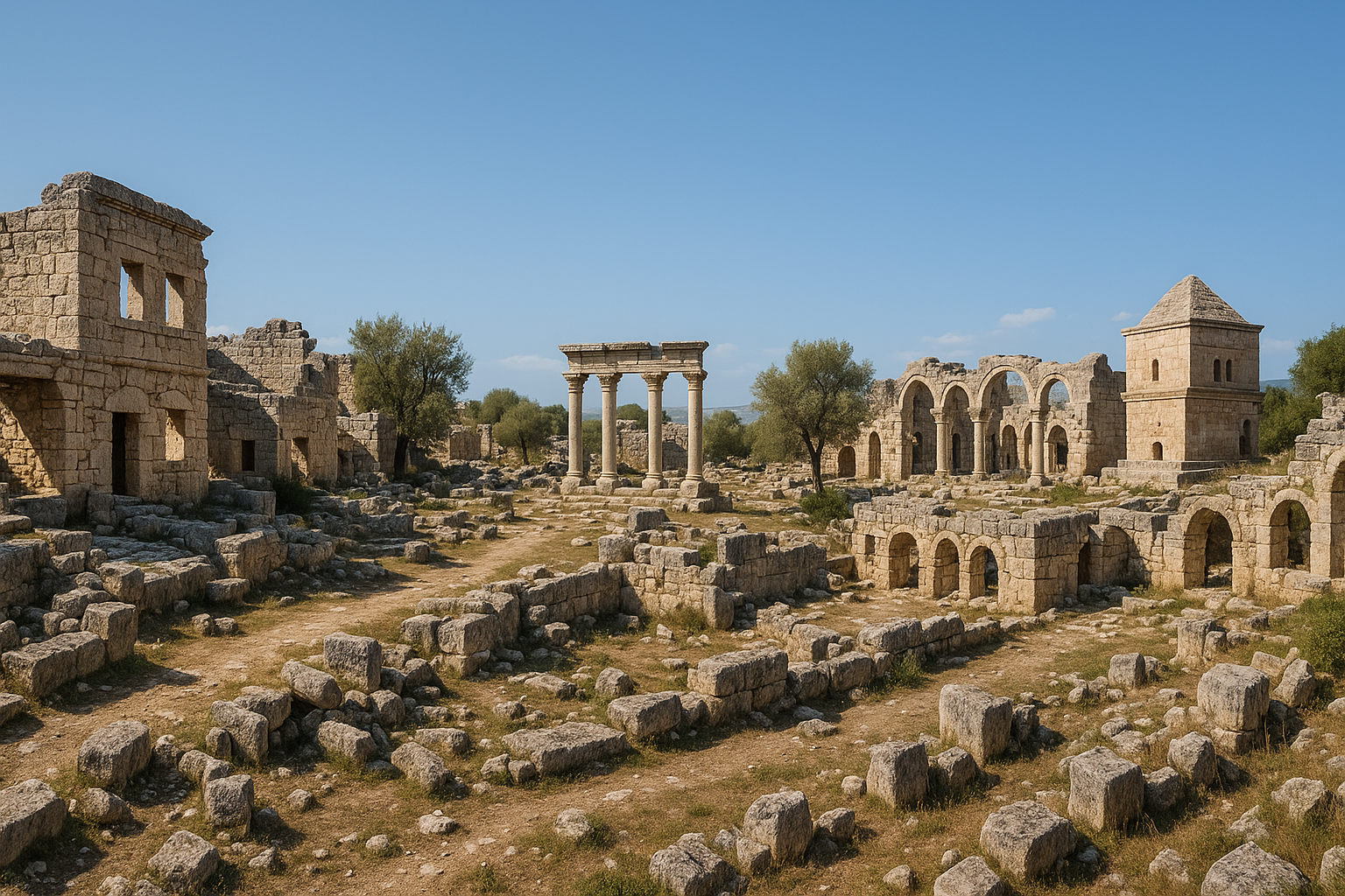
Overview: Anemurium is one of the most remarkably preserved ancient coastal cities in Türkiye, located on a dramatic rocky cape near modern Anamur in Mersin Province. Positioned at the southernmost point of Anatolia — the closest point on the Turkish mainland to Cyprus (just 64 km away) — Anemurium flourished as a major port and urban center during the Roman and Early Byzantine periods (1st–7th century AD). The site preserves an extraordinarily complete ensemble of ancient architecture: a vast necropolis with approximately 350 barrel-vaulted tomb houses (one of the largest and best-preserved Roman cemeteries in the Mediterranean), a theater, an odeon, multiple bath complexes, churches with stunning floor mosaics, an aqueduct, fortification walls, and a hilltop citadel. Despite its exceptional preservation, Anemurium remains relatively unknown — making it one of Türkiye's greatest hidden archaeological treasures.
- Why Anemurium Matters
- Geography and Setting
- Historical Timeline
- The Southernmost Point of Anatolia
- The Great Necropolis
- Tomb Architecture and Frescoes
- The Mosaics
- The Theater
- The Odeon
- The Bath Complexes
- The Churches
- The Citadel and Fortifications
- The Aqueduct
- Urban Plan and Streets
- Economy and Maritime Trade
- The Arab Raids and Decline
- Archaeological Excavations
- The Anamur Museum
- How to Visit Anemurium
- FAQ
- Sources
Why Anemurium Matters
Anemurium is significant for several compelling reasons:
- Most complete Roman coastal city: One of the best-preserved ancient urban landscapes in Türkiye — entire neighborhoods, streets, public buildings, and hundreds of tombs survive
- 350+ barrel-vaulted tombs: The necropolis is one of the largest and best-preserved Roman-era cemeteries in the Mediterranean, with tomb interiors retaining original frescoes
- Stunning mosaics: Floor mosaics in churches and public buildings feature intricate geometric patterns and figural scenes — the leopard-and-palm mosaic is iconic
- Southernmost Anatolia: The closest point on the Turkish mainland to Cyprus — making Anemurium a strategic maritime gateway
- Complete urban infrastructure: Theater, odeon, five bath complexes, four churches, aqueduct, and fortifications — all preserved in a compact, walkable area
- Dramatic coastal setting: Ancient ruins spread across a rocky cape with the Mediterranean on three sides
- Undiscovered gem: Despite its exceptional preservation, Anemurium receives far fewer visitors than comparable sites
Geography and Setting
Anemurium occupies a dramatic cape at the southernmost tip of Anatolia.
Location:
- Near Anamur, Mersin Province
- On Cape Anamur (Anamur Burnu) — the southernmost point of the Anatolian peninsula
- Approximately 10 km southwest of Anamur town center
- Just 64 km from the coast of Cyprus — visible on clear days
- The ancient settlement extends from the coastal plain up to a fortified hilltop
Landscape:
- A rocky Mediterranean cape with the sea on three sides
- The lower city occupies a coastal plain behind a beach
- The upper city climbs the hillside to a fortified citadel
- The necropolis covers the western hillslope
- Mediterranean vegetation — maquis, carob trees, and wild herbs
- Banana plantations and citrus orchards in the surrounding agricultural area (Anamur is Türkiye's banana capital)
Climate:
- One of the warmest spots in Türkiye — Mediterranean climate with subtropical influences
- Hot summers (35°C+) and very mild winters
- The cape is exposed to sea winds which moderate temperatures
- Rain is concentrated in winter months
Historical Timeline
| Period | Date | Key Events |
|---|---|---|
| Hellenistic | 3rd–1st century BC | Settlement established; part of Rough Cilicia |
| Roman Republic | 1st century BC | Pompey pacifies Cilician pirates (67 BC) |
| Early Roman | 1st–2nd century AD | City develops; public buildings constructed |
| Peak prosperity | 3rd century AD | Maximum urban development; necropolis expands; mosaics created |
| Late Roman/Early Byzantine | 4th–6th century | Churches built; Christian community thrives |
| Arab raids | 7th century (especially 650s) | City devastated and gradually abandoned |
| Medieval | 8th–14th century | Reduced habitation in citadel area only |
| Modern excavation | 1960s–present | Canadian and Turkish teams |
The Southernmost Point of Anatolia
Anemurium's position at the southernmost tip of Asia Minor gave it unique strategic importance.
Geographic significance:
- Cape Anamur is the closest point on the Turkish mainland to the island of Cyprus — only 64 km across the sea
- On clear days, the mountains of Cyprus are visible from Anemurium
- This proximity made Anemurium a natural transit point for maritime traffic between Anatolia and Cyprus
- The cape was a landmark for ancient sailors navigating the Cilician coast
Strategic importance:
- Control of the strait between Anemurium and Cyprus was vital for maritime trade
- The city's position allowed it to profit from shipping passing around the cape
- During the Roman period, grain ships traveling from Egypt to Rome passed through these waters
- The Arab naval raids that destroyed Anemurium in the 7th century were partly aimed at controlling this strategic crossing to Cyprus
The Great Necropolis
The necropolis of Anemurium is the site's most impressive feature — a vast cemetery with approximately 350 tomb structures.
Description:
- Covers a large area on the western hillslope above the city
- Approximately 350 individual tomb structures — stone-built, barrel-vaulted funerary houses
- Many tombs preserve their original barrel-vaulted roofs intact — a rare survival
- Tombs are organized along streets and pathways, forming a "city of the dead" that mirrors the living city below
- Multi-chamber tombs with multiple burial niches (loculi) inside
Tomb types:
- Barrel-vaulted tomb houses: The most common type — rectangular stone buildings with semicircular barrel-vaulted roofs
- Two-story tombs: Some tombs have an upper floor accessible by external stairs
- Simple pit tombs: Simpler burials in rock-cut pits
- Sarcophagi: Freestanding stone coffins, some decorated with garlands and inscriptions
Significance:
- One of the largest and best-preserved Roman-era cemeteries in the entire Mediterranean
- The survival of hundreds of roofed tomb structures is extremely unusual — at most ancient sites, tomb roofs have collapsed
- The necropolis provides unparalleled evidence for Roman funerary architecture, customs, and social structure in Cilicia
Tomb Architecture and Frescoes
Many tombs in the Anemurium necropolis retain their interior frescoes — painted decorations that provide a vivid glimpse into ancient funerary art.
Frescoes:
- Wall paintings inside the tomb chambers, applied on plaster
- Common motifs include: garlands, birds, geometric patterns, fruits, and floral designs
- Some frescoes depict human figures — portraits of the deceased or mythological scenes
- Colors include red, yellow, blue, green, and black — remarkably vivid after nearly 2,000 years
- The frescoes are influenced by broader Roman painting traditions but show local Cilician characteristics
Significance:
- The Anemurium frescoes are among the best-preserved examples of Roman tomb painting in Anatolia
- They provide evidence for local artistic traditions and funerary beliefs
- The quality and quantity of preserved frescoes make Anemurium a key site for understanding Roman provincial art
The Mosaics
Anemurium preserves outstanding floor mosaics in its churches and public buildings.
Key mosaics:
- The Necropolis Church mosaic: The most famous — featuring a leopard and a capricorn flanking a palm tree, interpreted as a "Kingdom of Peace" symbol
- Geometric mosaics with intricate patterns — interlocking circles, diamonds, and braided borders
- Tabula ansata (inscription frames) recording the names of donors who funded the mosaics
- Plant and animal motifs — birds, fish, and vine scrolls
Current location:
- Some mosaics remain in situ (covered for protection)
- The leopard-and-palm mosaic is displayed in the Anamur Museum
- Fragments are also in the Mersin Museum
The Theater
The Theater of Anemurium is built into the hillside with views over the Mediterranean.
Features:
- Semi-circular cavea with seating for approximately 3,000–4,000 spectators
- Built into the natural hillslope — a common technique in Cilicia
- Well-preserved lower seating sections
- The stage building (scaenae frons) is partially preserved
- Sea views from the upper seating rows — a dramatic performance backdrop
Dating:
- Originally constructed in the 2nd century AD
- Modified during the 3rd century — the peak of Anemurium's prosperity
- Used for dramatic performances, musical events, and public assemblies
The Odeon
A smaller Odeon (roofed performance hall) complemented the larger theater.
Features:
- A semi-circular building smaller than the theater
- Capacity of approximately 800–1,000 spectators
- Originally roofed — used for musical performances, recitations, and council meetings
- Well-preserved seating rows and orchestra area
- Located in the lower (coastal) part of the city
The Bath Complexes
Anemurium had an unusually large number of bath complexes — at least five have been identified.
The baths:
- Multiple Roman-style bath buildings (thermae) serving different neighborhoods
- Standard Roman bath plan: frigidarium (cold room), tepidarium (warm room), caldarium (hot room)
- Hypocaust heating systems — raised floors with hot air channels beneath
- Mosaic floors and marble wall veneer in the more elaborate baths
- Water supply via the aqueduct
Significance:
- Five bath complexes for a city of Anemurium's size is unusually high — indicating a prosperous population that valued bathing culture
- The baths served as social centers as well as places of hygiene
- Their preservation provides detailed information about Roman bathing technology and architecture
The Churches
At least four early Christian churches have been identified at Anemurium.
Key churches:
- Necropolis Church: Built within the necropolis area — unusual location reflecting the importance of commemorating the dead
- Coastal Basilica: A large three-aisled basilica near the beach
- Additional smaller churches in the upper and lower city
- Mosaic floors in several churches (see Mosaics section above)
Dating:
- The churches date primarily to the 5th–6th centuries — the period of vigorous church-building across the Byzantine Empire
- They demonstrate the thorough Christianization of Anemurium
- The Necropolis Church's location among pagan tombs suggests the church was deliberately placed to Christianize the cemetery
The Citadel and Fortifications
A citadel crowns the hilltop above the city, and fortification walls encircle the settlement.
The citadel:
- A fortified enclosure on the highest point of the cape
- Massive walls with towers
- Last-resort defensive position for the population
- Views across the Mediterranean to Cyprus
Fortification walls:
- Walls encircling the lower and upper city
- Multiple construction phases from the Roman through Byzantine periods
- Towers at strategic intervals
- The walls were strengthened in the 7th century in response to Arab raids — but ultimately proved insufficient
The Aqueduct
A Roman aqueduct supplied Anemurium with fresh water.
Features:
- Carried water from mountain springs to the city
- Sections of the aqueduct channel are visible on the hillside
- Water was distributed to public fountains, baths, and private houses
- A system of cisterns supplemented the aqueduct supply
- The aqueduct's destruction during the Arab raids contributed to the city's abandonment
Urban Plan and Streets
Anemurium preserves a legible urban plan with identifiable streets and neighborhoods.
Layout:
- Lower city: Coastal plain — public buildings (theater, odeon, baths, churches), commercial area, and residential neighborhoods
- Upper city: Hillside — residential areas climbing toward the citadel
- Necropolis: Western slope — the vast cemetery
- Streets with stone paving connecting the different zones
- Shops and commercial spaces along main streets
- Private houses with courtyards and multiple rooms
Economy and Maritime Trade
Anemurium's economy was based on maritime trade and agriculture.
Maritime trade:
- The cape's strategic position on the Cilician shipping route generated trade revenue
- Ships rounding Cape Anamur stopped at the harbor for supplies and shelter
- Trade goods from Egypt, Cyprus, Syria, and the Aegean passed through Anemurium
- The proximity to Cyprus (64 km) facilitated direct trade
Agriculture:
- The Anamur plain is fertile — ancient crops included grain, olives, grapes, and fruits
- The warm, subtropical climate allowed for extended growing seasons
- Agricultural surplus was exported via the harbor
Population:
- At its peak (3rd century AD), Anemurium may have had a population of 10,000–20,000
- The large number of bath complexes and the extensive necropolis suggest a substantial and prosperous community
The Arab Raids and Decline
Anemurium's destruction came during the Arab-Byzantine wars of the 7th century.
The raids:
- Beginning in the 640s–650s, Arab naval forces raided the Cilician coast
- Anemurium, with its exposed coastal position and strategic proximity to Cyprus, was a prime target
- The city was attacked and heavily damaged — possibly multiple times
- The aqueduct was destroyed, cutting off the water supply
- The harbor facilities were damaged
- Much of the population fled inland
Aftermath:
- Unlike many ancient cities that gradually declined, Anemurium was abruptly abandoned in the mid-7th century
- The sudden abandonment is why so much is preserved — there was no gradual stripping of building materials
- Limited habitation continued in the citadel area during the medieval period
- The site was never significantly reoccupied, preserving the Roman and Byzantine urban landscape largely intact
Archaeological significance:
- The abrupt abandonment created a "time capsule" — buildings, mosaics, and frescoes were sealed by collapse rather than stripped for reuse
- This makes Anemurium comparable to Pompeii in terms of preservation (though the destruction mechanism was different)
Archaeological Excavations
Anemurium has been excavated by both Canadian and Turkish teams.
Elizabeth Rosenbaum-Alföldi (1960s–1970s):
- Canadian archaeologist who conducted the first systematic excavations
- Documented the necropolis, mosaics, and urban plan
- Published fundamental studies on the site
Subsequent work:
- Turkish archaeological teams have continued research, conservation, and site management
- Conservation of mosaics and frescoes
- Documentation of the necropolis tomb by tomb
- Development of the site for tourism
Publications:
- The excavation reports and specialist studies have made Anemurium well-known in academic circles
- However, the site remains relatively unknown to the general public and tourists
The Anamur Museum
The Anamur Archaeological Museum displays finds from Anemurium and the surrounding region.
Collections:
- The famous leopard-and-palm mosaic from the Necropolis Church
- Pottery, glass, and metal objects from the necropolis
- Coins from various periods
- Architectural fragments and inscriptions
- Small finds illustrating daily life in ancient Anemurium
How to Visit Anemurium
Getting there:
- From Anamur: 10 km southwest (about 15 minutes)
- From Mersin: 230 km (about 3.5 hours via the coastal D-400)
- From Antalya: 250 km (about 4 hours via the coastal D-400)
- From Silifke: 130 km (about 2 hours)
- Well-signposted from the D-400 coastal highway
- Limited public transport; rental car or taxi recommended
The site:
- Allow 2–3 hours for a thorough visit
- Key stops: Necropolis (barrel-vaulted tombs, frescoes), theater, odeon, bath complexes, churches (mosaics), citadel (panoramic views to Cyprus)
- The site is spread across a large area — comfortable walking shoes essential
- Uphill walking required to reach the citadel
- Entry fee required; basic facilities at the entrance
Best time to visit:
- Spring (March–May) is ideal — wildflowers, pleasant temperatures
- Autumn (October–November) also excellent
- Summer is very hot (35°C+) — visit early morning or late afternoon
- Winter is mild but can be rainy
Practical tips:
- Bring water and sun protection — limited shade
- Carry a flashlight to see fresco details inside tomb chambers
- Photography is spectacular — the combination of ancient ruins and Mediterranean Sea is stunning
- Combine with nearby Mamure Castle (3 km east) — one of the best-preserved medieval castles on the Turkish coast
- Visit the Anamur Museum to see the famous mosaics
- Anamur has hotels, restaurants, and beautiful banana-backed beaches
FAQ
Q: Why is Anemurium so well preserved? A: The city was abruptly abandoned after Arab raids in the 7th century. Because it was never significantly reoccupied, buildings, frescoes, and mosaics were preserved rather than stripped for building materials.
Q: Can you see Cyprus from Anemurium? A: Yes, on clear days. The mountains of northern Cyprus are visible from the citadel and upper parts of the site — only 64 km across the sea.
Q: What are the barrel-vaulted tombs? A: Stone-built funerary houses with semicircular vaulted roofs. About 350 survive at Anemurium — one of the largest collections of Roman tombs with intact roofs in the Mediterranean.
Q: Are the frescoes still visible? A: Yes. Many tomb interiors retain their original painted plaster with scenes of garlands, birds, and human figures. A flashlight helps to see the details.
Q: Where are the mosaics? A: Some remain in situ (covered for protection). The most famous pieces, including the leopard-and-palm mosaic, are in the Anamur Museum.
Q: Is the site physically demanding? A: Moderately. The lower city is relatively flat, but reaching the citadel requires a steep uphill walk. The necropolis involves walking on uneven hillside terrain.
Q: How does Anemurium compare to other ancient cities? A: Anemurium is comparable to Pompeii in terms of preservation quality — a sudden abandonment created a "time capsule." However, it receives far fewer visitors, making it one of Türkiye's greatest undiscovered archaeological treasures.
Spatial Measurements and Urban Extent
Detailed survey and excavation data provide a precise picture of Anemurium's urban footprint:
| Zone / Structure | Measurement | Notes |
|---|---|---|
| Acropolis (upper city) peak elevation | ~149 m above sea level | Fortified hilltop citadel |
| Acropolis total area | ~73,000 m² | Enclosed by defensive walls with towers |
| Lower city extent (north) | ~1,500 m long x 400 m wide | From citadel base to sand dune zone |
| Necropolis area | ~101,000 m² (south to north) | Western hillslope; ~350 tomb structures |
| Distance to Cyprus | 64 km | Closest point on Turkish mainland to Cyprus |
| Distance from Anamur town | ~10 km southwest | Along the coastal road |
Necropolis Tomb Typology
Elisabeth Alfoldi-Rosenbaum's systematic documentation of the necropolis established a detailed classification of tomb types:
| Tomb Type | Description | Approximate Count |
|---|---|---|
| Barrel-vaulted tomb houses | Rectangular stone structures with semicircular vaulted roofs; most common type | Majority of ~350 tombs |
| Baldachin / Mausoleum type | Open-sided canopy structures supported by pillars | Scattered examples |
| Truncated conical type | Circular-plan tombs with tapering upper walls | Rare form |
| Exedra / Aedicule type | Niched facades with architectural decoration | Several documented |
| Domed type | Circular-plan tombs with hemispherical domes | Rare form |
| Two-story tombs | Multi-level structures with external staircases | Limited number |
| Simple pit tombs | Rock-cut or ground-level burials without superstructure | Numerous |
| Freestanding sarcophagi | Decorated stone coffins; some with garland reliefs and inscriptions | Scattered throughout |
The tombs date primarily to the 1st through 4th centuries AD, with the majority concentrated in the 2nd and 3rd centuries — the period of Anemurium's greatest prosperity. The survival of hundreds of intact barrel-vaulted roofs is extremely unusual in Mediterranean archaeology; at most comparable sites, tomb roofs collapsed centuries ago.
Fresco Iconography and Painting Techniques
The tomb frescoes at Anemurium constitute one of the largest surviving collections of Roman provincial funerary painting in Anatolia:
| Motif Category | Examples |
|---|---|
| Floral | Garlands, vine scrolls, roses, wreaths |
| Avian | Peacocks, doves, songbirds — symbols of the soul and the afterlife |
| Figural | Portraits of the deceased; deities; personifications of the Seasons |
| Mythological | Scenes drawn from Greco-Roman mythology |
| Geometric | Interlocking circles, meanders, diamond lattice patterns |
| Secular / Daily life | Banqueting scenes; worldly celebrations |
Pigments identified include iron-oxide reds, carbon blacks, lime whites, and copper-based greens and blues. The paintings were applied to fresh lime plaster (true fresco technique) in the more elaborate tombs, while simpler examples used tempera on dry plaster (secco technique). The remarkable preservation is attributed to the sealed tomb chambers protecting the painted surfaces from weathering after the city's abandonment.
Mosaic Pavements and Donor Inscriptions
The mosaic floors at Anemurium include both geometric and figural designs of high quality:
| Building | Mosaic Description |
|---|---|
| Necropolis Church | Leopard and capricorn flanking a palm tree — the "Kingdom of Peace" mosaic; tabula ansata inscriptions naming donors |
| Palaestra | Geometric mosaic pavements with inscription panels recording benefactors |
| Coastal Basilica | Polychrome geometric designs with vine-scroll borders |
| Bath complexes | Simpler geometric tessellation in black and white |
Mosaic inscriptions from the palaestra, studied by scholars from Cambridge University, provide valuable evidence for the names and social status of local civic benefactors — individuals who funded public buildings and expected commemorative recognition in return.
Excavation Chronology and Key Personnel
| Phase | Personnel | Period | Key Contributions |
|---|---|---|---|
| Initial survey | George E. Bean & Terence B. Mitford | 1960s | First systematic documentation; published Journeys in Rough Cilicia |
| Major excavation | Elisabeth Alfoldi-Rosenbaum (Canadian) | 1960s–1970s | Comprehensive necropolis documentation; mosaic studies; site plan |
| Continued research | Turkish archaeological teams | 1980s–present | Conservation of mosaics and frescoes; tomb-by-tomb documentation |
| Site management | Turkish Ministry of Culture | Ongoing | Tourism infrastructure; site protection; museum development |
A notable recent discovery includes an inscription for an ancient wrestler found at the site, adding to the evidence for the importance of athletic culture in Roman Cilician cities. The inscription records the victories and honours of a professional athlete, a type of document well attested in the Roman eastern provinces.
Comparative Context
Anemurium's preservation profile is frequently compared to other "time capsule" sites:
| Comparison | Anemurium | Pompeii | Ephesus |
|---|---|---|---|
| Destruction mechanism | Arab raids (7th c.) | Vesuvius eruption (79 AD) | Gradual silting and decline |
| Abandonment | Abrupt | Abrupt | Gradual |
| Building material reuse | Minimal (never reoccupied) | Minimal (buried) | Extensive (continuous occupation) |
| Tomb preservation | Exceptional (~350 roofed tombs) | Necropolis along roads | Scattered examples |
| Annual visitors | Low (thousands) | Very high (millions) | Very high (millions) |
The relative obscurity of Anemurium is itself an asset for researchers: the lack of significant post-abandonment disturbance means that stratified deposits, floor levels, and architectural details survive in a condition rarely matched at more heavily visited or reoccupied sites.
Sources
- Rosenbaum-Alföldi, Elizabeth. Excavation reports, Anemurium
- Turkish Museums, "Mersin Anemurium Archaeological Site"
- Wikipedia, "Anemurium"
- Bean, George E. and Mitford, Terence B. Journeys in Rough Cilicia
- Hild, Friedrich and Hellenkemper, Hansgerd. Tabula Imperii Byzantini: Kilikien und Isaurien
- Republic of Türkiye Ministry of Culture and Tourism — Mersin cultural heritage
- Anamur Museum exhibition catalogue