نظرة سريعة: أنافارزا (المعروفة قديمًا باسم أنازاربوس، ثم قيصرية أنازاربوم) هي واحدة من أكبر المدن القديمة وأكثرها إثارةً في جنوب تركيا، وتمتدّ على مساحة شاسعة عبر سهل جوكوروفا (كيليكيا) عند سفح كتلة صخرية شاهقة ارتفاعها 200 متر قرب قوزان في أضنة. أُسِّست في العصور القديمة وبلغت أوج مجدها في عهد الإمبراطورية الرومانية، إذ نافست أنافارزا طرسوس على لقب عاصمة كيليكيا، وانتزعت في نهاية المطاف لقبَي المتروبوليس والنيوكوروس (حارسة المعبد) في عهد الإمبراطور سبتيميوس سيفيروس مطلعَ القرن الثالث الميلادي. يضمّ الموقع قوسًا انتصاريًا ثلاثي العقود (علاقابي — القوس الانتصاري الروماني الوحيد في كيليكيا)، وأحد أوسع الشوارع المعمّدة في العالم القديم (34 مترًا)، فضلًا عن ملعب ضخم، ومسرح، وحمامات، وقنوات مياه، وقلعة بديعة على قمة الجبل، وفسيفساء بيزنطية رائعة. وُلد في هذه المدينة الطبيب الشهير ديوسقوريدس — "أبو علم الأدوية" — وأنافارزا مُدرَجة في قائمة اليونسكو التمهيدية لمواقع التراث العالمي في تركيا، وتخضع للتنقيب المنهجي منذ عام 2012.
جدول المحتويات
- لماذا تُعدّ أنافارزا مهمة
- الجغرافيا والموقع
- الجدول الزمني التاريخي
- القوس الانتصاري علاقابي
- الشارع المعمّد
- الملعب والمسرح
- قلعة أنافارزا
- الحمامات والقنوات والبنية التحتية
- الفسيفساء والكنائس
- ديوسقوريدس والحياة الفكرية
- التنافس مع طرسوس
- الحفريات الأثرية
- معلومات الزيارة
- الأسئلة الشائعة
- المصادر وقراءات إضافية
لماذا تُعدّ أنافارزا مهمة
تكتسب أنافارزا أهميتها من أسباب متعدّدة:
الحجم والحفظ: يمتدّ الموقع على مساحة هائلة — تمتدّ المدينة السفلى على مسافة تزيد على كيلومتر واحد على طول الشارع المعمّد، فيما تحتلّ القلعة أعلاه قمة الكتلة الصخرية بأسرها. ويُشكّل تراكب البقايا الرومانية والبيزنطية والأرمنية وتلك العائدة إلى حقبة الحملات الصليبية مشهدًا أثريًا بالغ الثراء والتعقيد.
القوس الانتصاري: يُمثّل علاقابي (البوابة الثلاثية الانتصارية) القوسَ الانتصاري الروماني الوحيد الباقي في كيليكيا وأحد أرقى نظيراته في الأناضول كلّها. يجعله حجمه الشامخ (قرابة 8 أمتار ارتفاعًا) وزخارفه الغنية معلمًا معماريًا استثنائيًا.
تاريخ الطب: كانت أنافارزا مسقط رأس بيدانيوس ديوسقوريدس (نحو 40–90 م)، الذي ظلّ عمله الموسوعي في خمسة مجلدات دي ماتيريا ميديكا المرجعَ الدوائي القياسي في العالمَين الإسلامي والأوروبي لأكثر من 1500 عام.
التنافس الحضري: شكّل التنافس بين أنافارزا وطرسوس على لقب عاصمة كيليكيا حالةً دراسية رائعة في التنافس المدني القديم — تجلّى في نقوش العملات، والألقاب الفخرية، وأعمال البناء الضخمة.
الاستمرارية: يمتدّ تاريخ إشغال الموقع من العصر الكالكوليتي (نحو 5000 ق.م) إلى المملكة الأرمنية في كيليكيا (القرنان الثاني عشر والرابع عشر الميلاديان)، محيطًا بأكثر من 7000 عام من الحضور الإنساني.
الجغرافيا والموقع
تقع أنافارزا على بُعد نحو 30 كيلومترًا جنوب قوزان (سيس القديمة) في محافظة أضنة، على الطرف الشرقي من سهل جوكوروفا — السهل الواسع الخصيب لكيليكيا بيدياس (كيليكيا المسطّحة) القديمة.
السمة التعريفية للموقع هي صخرة أنافارزا — كتلة حجر كلسي شاهقة ترتفع نحو 200 متر فوق السهل المحيط بها، بطول نحو 1.5 كيلومتر وعرض 800 متر. وقد وفّرت هذه القلعة الطبيعية خلفيةً درامية ومركزَ دفاع منيعًا.
معالم المنطقة
- الكتلة الصخرية: يهيمن النتوء المتوّج بالقلعة على المشهد لكيلومترات في كلّ اتجاه
- سهل جوكوروفا: واحد من أخصب المناطق الزراعية في البحر المتوسط — إنتاج الحبوب قديمًا، وزراعة القطن والحمضيات حديثًا
- نهر سمباس: رافد نهر جيهان (بيراموس القديم) يجري قرب الموقع، ويُمدّ المدينة القديمة بالمياه
- شبكة الطرق: كانت أنافارزا تقع عند تقاطع الطرق التي تربط طرسوس وأضنة بحدود الفرات وشمال بلاد ما بين النهرين — موقع استراتيجي للتجارة والخدمات اللوجستية العسكرية
المناخ حارّ متوسطي — الصيف حارق (40°م وما فوق)، ممّا يجعل الربيع والخريف الموسمَين المفضَّلَين للزيارة.
الجدول الزمني التاريخي
العصر الكالكوليتي وعصر البرونز (نحو 5000–1200 ق.م)
تُشير الشواهد الأثرية إلى وجود إنساني في أنافارزا منذ العصر الكالكوليتي (نحو 5000 ق.م). كان الموقع الدفاعي الطبيعي يستقطب المستوطنين الأوائل. وخلال عصر البرونز، كانت المنطقة جزءًا من دائرة النفوذ الحيثية بوصفها أرض كيزوواتنا.
التأسيس الهلنستي (نحو القرن الثاني ق.م)
جرى تأسيس مدينة أنازاربوس أو إعادة تأسيسها على الأرجح خلال الحقبة السلوقية. قد يكون الاسم مشتقًّا من اسم طبوغرافي أناضولي محلّي. وفي ظلّ حكم السلوقيين، بدأت المدينة في تطوير بنيتها التحتية الحضرية.
الحقبة الرومانية (القرن الأول ق.م – القرن الرابع م)
ازدهرت أنافارزا في ظلّ الحكم الروماني:
- القرن الأول ق.م: ضُمّت إلى الولاية الرومانية في كيليكيا
- 19 م: أُعيدت تسميتها قيصرية أنازاربوم على يد الإمبراطور جرمانيكوس
- الحقبة الفلافية (69–96 م): نشاط بناء مكثّف
- 198 م: مُنحت لقب النيوكوروس (حارسة المعبد) من قِبَل سبتيميوس سيفيروس — الحقّ في استضافة معبد العبادة الإمبراطورية
- 204 م: رُقّيت إلى متروبوليس — العاصمة الإدارية لكيليكيا سيكوندا (كيليكيا الثانية)، منتزِعةً هذا الشرف من طرسوس
- القرنان الثاني والثالث الميلاديان: فترة الازدهار الأقصى — القوس الانتصاري والشارع المعمّد والملعب والمباني العامة الكبرى تعود إلى هذه الحقبة
الحقبة البيزنطية (القرنان الرابع والحادي عشر الميلاديان)
غدت أنافارزا مدينة حدودية بيزنطية بارزة:
- مقرّ أسقف في التسلسل الكنسي
- شُيّدت كنائس وبازيليكات متعددة زُيّنت بـأرضيات فسيفساء فاخرة
- ألحقت الغارات العربية المتكررة منذ القرن السابع أضرارًا متكررة بالمدينة
- 525 م و561 م: زلازل مدمّرة أتت على معظم المدينة؛ أُعيد بناؤها على يد الإمبراطور جوستينيان الأول
- أدّت المدينة دور القاعدة المتقدّمة خلال النزاعات الحدودية البيزنطية-العربية
المملكة الأرمنية في كيليكيا (القرنان الحادي عشر والرابع عشر الميلاديان)
بعد وصول الأرمن إلى كيليكيا في أعقاب الفتح السلجوقي لأوطانهم:
- أصبحت أنافارزا معقلًا رئيسيًا لـالمملكة الأرمنية في كيليكيا (أرمينيا كيليكيا)
- جرى إعادة بناء القلعة وتوسيعها توسيعًا مكثّفًا بأسوار تحصين أرمنية
- خدمت المدينة لفترة وجيزة عاصمةً أرمنية في مطلع القرن الثاني عشر
- أُضيفت كنائس وإنشاءات أرمنية إلى النسيج العمراني القائم
الفتح المملوكي والهجران
أنهى الغزو المملوكي عام 1375 المملكةَ الأرمنية في كيليكيا. نُهبت أنافارزا وهُجرت في معظمها. لم يُعاد إشغال الموقع بوصفه مستوطنة كبرى، ممّا أسهم في الحفاظ على بقاياها الأثرية والعصور الوسطى.
القوس الانتصاري علاقابي
يُعدّ علاقابي ("البوابة الزخرفية") أيقونةَ أنافارزا الأثرية بامتياز:
- بوابة انتصارية ثلاثية العقود — عقد مركزي كبير يتجانب إليه عقدان جانبيان أصغر
- القوس الانتصاري الروماني الوحيد الباقي في كيليكيا
- الارتفاع التقديري: نحو 8 أمتار
- شُيّد من حجر كلسي منحوت بدقة متناهية
- يُؤرَّخ في القرنين الثاني والثالث الميلاديين، ويُرجَّح أنه يُحيي ذكرى ارتقاء أنافارزا إلى رتبة المتروبوليس
- أدّى القوس دور المدخل الفخري للشارع المعمّد من الجانب الجنوبي
- يتميّز بزخارف غنية من أعمدة كورنثية، وتقاطيع إفريز، وألواح نقشية
- يرى بعض الباحثين في مشاهد النقوش البارزة تصويرًا لـانتصارات عسكرية أو مراسم إمبراطورية
- قد يعكس الاسم المحلي "علاقابي" (البوابة الملوّنة/الزخرفية) تلوينًا بوليكرومًا أصيلًا — وقد لُوحظت آثار ألوان على السطح
تكشف المقارنة مع أقواس انتصارية أناضولية أخرى (كبوابة هادريان في أنطاليا أو القوس الثلاثي في باتارا) أنّ قوس أنافارزا يندرج ضمن أكثر هذه الأقواس طموحًا في المنطقة.
الشارع المعمّد
الشارع الرئيسي المعمّد (كاردو ماكسيموس) هو من أعرض الشوارع في العالم القديم:
- العرض الإجمالي: نحو 34 مترًا — أوسع من الشوارع المعمّدة في أفسوس وبيرغي وأباميا
- الطول: يزيد على كيلومتر واحد يمتدّ شمالًا-جنوبًا عبر المدينة السفلى
- تصطفّ على جانبَيه أعمدة كورنثية تحمل رواقات مسقوفة
- كانت تفتح على الممرّات المسقوفة محلّات تجارية وورش صناعية — المعادل القديم للمراكز التجارية المغطّاة
- فُرش الشارع بـبلاطات كلسية ضخمة
- تجري تحت الرصيف قنوات صرف
- يربط الشارع القوسَ الانتصاري (جنوبًا) بالبوابة الشمالية والطريق المؤدي إلى القلعة
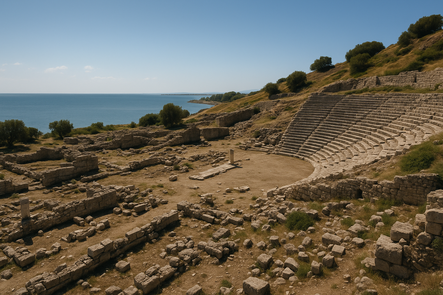
الملعب والمسرح
الملعب
يُعدّ ملعب أنافارزا من أكبر ملاعب الأناضول:
- الأبعاد: نحو 400 × 60 مترًا
- منحوت جزئيًا في الصخر عند قاعدة الكتلة الجبلية
- الطاقة الاستيعابية المقدّرة: 20,000–30,000 متفرج
- كان يُستخدم لسباقات الألعاب الرياضية وسباقات العربات وربما المبارزات الجلاديرية
- يُوثّق لوح نقشي من القرن الثاني الميلادي اكتُشف خلال الحفريات التقليدَ الجلاديري في أنافارزا، إذ يُصوّر مشاهد مبارزة
المسرح
- شُيّد على المنحدرات السفلى للكتلة الصخرية
- الطاقة الاستيعابية المقدّرة: 8,000–10,000 مقعد
- مدرّج المقاعد (كافيا) منحوت جزئيًا في الصخر وجزئيًا مشيّد
- انهار مبنى المسرح (سكيناي فرونس) غير أنّ شظايا زخارفه الغنية لا تزال باقية
- إنشاء روماني بتعديلات لاحقة
قلعة أنافارزا
تحتلّ القلعة قمة الكتلة الصخرية البالغة 200 مترًا بأسرها:
- واحدة من أضخم مجمّعات القلاع في جنوب تركيا
- إنشاء متعدد الحقب: مراحل رومانية وبيزنطية وأرمنية وربما صليبية
- الأسوار التحصينية الأرمنية هي الأكثر وضوحًا، بأسلوبها المميّز في بناء نوى الأنقاض وأبراجها النصف دائرية
- درج محفور في الصخر يصل المدينة السفلى بقمة القلعة
- داخل القلعة: بقايا قصر وكنيسة وصهاريج مياه وغرف تخزين
- مناظر بانورامية بزاوية 360 درجة على سهل جوكوروفا من القمة
- كانت القلعة آخر ملجأ في أوقات الحصار — جعلتها جروفها الشاهقة منيعةً بالكاد من أيّ هجوم مباشر
الحمامات والقنوات والبنية التحتية
الحمامات الرومانية
جرى التعرّف على مجمّعات حمامات (ثيرمي) متعددة:
- يشتمل مجمّع الحمامات الكبير قرب الشارع المعمّد على أقسام الفريجيداريوم (الغرفة الباردة) والتيبيداريوم (الغرفة الدافئة) والكالداريوم (الغرفة الساخنة)
- نظام تدفئة هيبوكوست بأعمدة الطوب (بيلاي الدعّامات) لا تزال مرئية
- كسوات رخامية للجدران وأرضيات فسيفساء في بعض الأقسام
قنوات المياه
جلبت قناة مياه متعددة الأقسام المياه من مصادر جبلية:
- أقسام مشيّدة من الحجارة باقية على طول المسار المؤدي إلى المدينة
- نظام توزيع المياه يشتمل على أنابيب فخارية وقنوات حجرية
- دعم نظام المياه كلًا من النوافير العامة (النيمفايا) ومجمّعات الحمامات
المقبرة
تحيط بالمدينة مناطق مقبرة واسعة:
- مقابر محفورة في وجوه الجروف
- تابوت حجرية من حقب مختلفة
- واجهات بعض المقابر مزيّنة بنقوش بارزة
الفسيفساء والكنائس
تحتوي كنائس أنافارزا البيزنطية على بعض أرقى أرضيات الفسيفساء في كيليكيا:
فسيفساء الكنائس
- كشفت الحفريات منذ عام 2012 عن أرضيات فسيفسائية واسعة في مبانٍ كنسية متعددة
- تشمل الموضوعات أنماطًا هندسية ولفائف كرمة وطيورًا وحيوانات ونقوشًا
- تتميّز لوحة فسيفساء استثنائية من القرنين الخامس والسادس بـمشاهد صيد برسوم حيوانات دقيقة التفاصيل
- تدلّ الفسيفساء على ثروة أنافارزا البيزنطية ورقيّها الفني
عمارة الكنائس
- جرى التعرّف على عدة كنائس ذات مخطط بازيليكي في المدينة السفلى
- تتميّز إحدى البازيليكات الكبرى بـمخطط ثلاثي الأروقة مع ابسيدة نصف دائرية
- تشتمل النحوتات المعمارية على تيجان كورنثية وأفاريز منحوتة وإطارات نوافذ زخرفية
ديوسقوريدس والحياة الفكرية
ابن أنافارزا الأشهر هو بيدانيوس ديوسقوريدس (نحو 40–90 م):
- وُلد في أنازاربوس وخدم طبيبًا عسكريًا في الجيش الروماني
- ألّف دي ماتيريا ميديكا — موسوعة في خمسة مجلدات عن علم الأدوية تصف نحو 600 نبتة و35 منتجًا حيوانيًا و90 معدنًا مع استخداماتها الطبية
- ظلّ الكتاب المرجع المعياري في علم الأدوية لأكثر من 1500 عام في كلٍّ من العالم الإسلامي (نُقل إلى العربية على يد حنين بن إسحاق) وأوروبا في العصور الوسطى
- يستبق أسلوب ديوسقوريدس المنهجي في توثيق الأدوية — من وصف طريقة تحضير كلّ مادة وجرعتها وتأثيراتها — المنهجيةَ الدوائية الحديثة
- تتضمّن عملات المدينة أحيانًا صور رموز طبية (حية أسكليبيوس) ربما تكريمًا لطبيبها الشهير
- يُمثّل ديوسقوريدس الثقافة الفكرية الأشمل لكيليكيا الرومانية التي أنجبت أيضًا الفيلسوف الرواقي خريسيبوس (من سولي المجاورة)
التنافس مع طرسوس
من أكثر جوانب تاريخ أنافارزا رواءً تنافسها المدني مع طرسوس:
- كانت طرسوس العاصمة التقليدية لكيليكيا — مسقط رأس القديس بولس ومركزًا ثقافيًا بارزًا
- تحدّت أنافارزا هذه السيادة من خلال أعمال بناء ضخمة طموحة، ساعيةً إلى انتزاع ألقاب فخرية من روما
- في 198 م، فازت أنافارزا بالحصول على لقب النيوكوروس الثمين من سبتيميوس سيفيروس
- في 204 م، رُقّيت أنافارزا إلى متروبوليس لكيليكيا سيكوندا — ممّا أفضى عمليًا إلى تقسيم كيليكيا وجعل أنافارزا عاصمةَ قسمها الشرقي
- يُوثَّق هذا التنافس في نقوش العملات: تُعلن عملات أنافارزا بفخر عن ألقابها (ΜΗΤΡΟΠΟΛΙΣ، ΝΕΩΚΟΡΟΣ) تأكيدًا للمكانة المدنية
- دفع هذا التنافس المدينتَين إلى الاستثمار بكثافة في العمارة العامة — مخلّفًا أطلالًا شامخة تتجلّى فيها عظمة الماضي
الحفريات الأثرية
الاستكشافات الأولى
- وصف رحّالة أوروبيون في القرن التاسع عشر الأطلال
- فيكتور لانغلوا (1852) نشر أوّل توصيفات منهجية
- وثّقت بعثات مسح متعددة معالم بعينها
الحفريات الحديثة (2012 – حتى الآن)
تُجرى حفريات منهجية منذ عام 2012 تحت إشراف جامعة جوكوروفا:
- حفريات الشارع المعمّد والمباني المجاورة
- اكتشاف نقوش جلاديرية تُؤكّد قتال الحلبة في الملعب
- الكشف عن أرضيات فسيفساء بيزنطية واسعة في المباني الكنسية
- توثيق مجمّع القلعة متعددة الحقب
- أعمال صون على القوس الانتصاري
- كشفت الحفريات أنّ الإشغال البشري للمدينة يعود إلى العصر الكالكوليتي (نحو 5000 ق.م)
قائمة اليونسكو التمهيدية
أُدرجت أنافارزا في قائمة اليونسكو التمهيدية لمواقع التراث العالمي في تركيا عام 2014، اعترافًا بقيمتها العالمية الاستثنائية بوصفها مشهدًا أثريًا متعدد الحقب.
معلومات الزيارة
الموقع: على بُعد نحو 30 كيلومترًا جنوب قوزان، محافظة أضنة. يقع الموقع الأثري قرب قرية ديلك قايا.
الوصول: بالسيارة من أضنة (نحو 1.5 ساعة شرقًا عبر طريق أضنة-قوزان، ثم جنوبًا). من قوزان، اتّبع لافتات الاتجاه نحو ديلك قايا/أنافارزا. لا توجد وسيلة نقل عامة منتظمة مباشرة إلى الموقع.
ساعات العمل: مفتوح يوميًا خلال ساعات النهار.
رسوم الدخول: قد تُفرض رسوم رمزية خلال مواسم الحفر النشطة.
مدة الزيارة: ساعتان إلى أربع ساعات كحدّ أدنى. الموقع كبير جدًا — خصّص نصف يوم كاملًا للاستكشاف الشامل بما في ذلك صعود القلعة.
صعود القلعة: الصعود إلى قمة القلعة شاقٌّ ومُرهق — خصّص 30 إلى 45 دقيقة في كلّ اتجاه. الممرّ وعِر ومكشوف. لا يُنصح به في حرارة الصيف أو لذوي صعوبات الحركة. المناظر من القمة خلّابة.
زيارات مشتركة:
- قوزان — قلعة قوزان (حصن أرمني)، المدينة القديمة
- قادرلي — منتزه كاراتيبي-أسلانطاش الوطني (حصن حثّي حديث بنقوش ثنائية اللغة)
- أضنة — تاشكوبرو (الجسر الحجري الروماني)، متحف أضنة الأثري
- مسيس (مبسهستة) — الجسر الروماني وفسيفساء سفينة نوح
نصائح:
- ابدأ الزيارة في ساعة مبكرة من الصباح، لا سيّما في الطقس الحارّ
- احرص على إحضار كميات وافرة من المياه — الظلّ شحيح في الموقع
- القوس الانتصاري والشارع المعمّد هما أبرز ما لا يُفوَّت
- يكافئ صعود القلعة الجهدَ المبذول بمناظر بانورامية استثنائية
- ارتدِ أحذية متينة لصعود القلعة
- الموقع لا يزال قيد التنقيب النشط — قد تكون بعض المناطق مقيّدة
- يمكن الجمع بين الزيارة وزيارة كاراتيبي لقضاء يوم كامل في علم آثار كيليكيا
الأسئلة الشائعة
ما هي أنافارزا؟ واحدة من أكبر المدن القديمة في كيليكيا (جنوب تركيا)، تقع عند سفح كتلة صخرية ارتفاعها 200 متر. خدمت عاصمةً لكيليكيا سيكوندا في العهد الروماني وتحتضن قوسًا انتصاريًا وملعبًا وشارعًا معمّدًا وقلعةً وفسيفساء بيزنطية.
من هو ديوسقوريدس؟ بيدانيوس ديوسقوريدس (نحو 40–90 م) وُلد في أنافارزا وألّف دي ماتيريا ميديكا، أكثر النصوص الدوائية تأثيرًا في التاريخ، استُخدم لأكثر من 1500 عام.
هل هي موقع يونسكو؟ أنافارزا مُدرَجة في قائمة اليونسكو التمهيدية لمواقع التراث العالمي في تركيا (منذ 2014)، غير أنها لم تُدرَج رسميًا بعد.
كيف تُقارَن بالمدن القديمة الأخرى في تركيا؟ من حيث الحجم، تُنافس أنافارزا أفسوس وبيرغي. شارعها المعمّد أوسع من شارع أفسوس (34 مترًا مقابل 11 مترًا). تُضيف القلعة بُعدًا رأسيًا درامانيًا لا تكاد تتّسم به أغلب المواقع الساحلية.
هل يمكن صعود القلعة؟ نعم، وإن كان الصعود شاقًّا ويستغرق 30 إلى 45 دقيقة. المناظر من القمة هي من أفضل المناظر في جنوب تركيا.
القياسات المعمارية وبيانات المسح الإنشائي
أنتجت الحفريات المنهجية منذ عام 2012 تحت إشراف جامعة جوكوروفا قياسات تفصيلية للمعالم الكبرى في أنافارزا، ممّا يُؤكّد مكانتها بوصفها أحد أضخم المشاريع الحضرية وأكثرها طموحًا في كيليكيا الرومانية.
الشارع المعمّد: المواصفات الهندسية
| الخاصية | القياس / التفصيل |
|---|---|
| العرض الإجمالي | 34 مترًا (من أعرض الشوارع في العالم القديم) |
| الطول الموثّق الإجمالي | 2700 متر |
| تكوين المسارات | طريق ذو مسارَين مقسومَين — أوّل مثال معروف من نوعه في العصور القديمة |
| نظام الأعمدة | كورنثي، مع رواقات مسقوفة على الجانبين |
| الرصيف | بلاطات حجر كلسي ضخمة |
| الصرف الصحي | قنوات تحت أرضية أسفل الرصيف |
| المحلات التجارية | مرافق تجارية تفتح على ممرّات مسقوفة على الجانبين |
| تاريخ الاكتشاف | موسم الحفر 2013 |
للمقارنة، يبلغ عرض الشارع المعمّد في أفسوس نحو 11 مترًا، وفي بيرغي 20 مترًا، وفي أباميا (سوريا) 37 مترًا. يضع عرض أنافارزا البالغ 34 مترًا شارعها ضمن أعرض ثلاثة شوارع معمّدة في العالم الروماني بأسره. كما يجعل الطول الموثّق البالغ 2700 متر هذا الشارع من أطول هذه الشوارع أيضًا.
المدرّج / الحلبة: البيانات الإنشائية
| الخاصية | القياس / التفصيل |
|---|---|
| الشكل | بيضوي (شكل الأمفيثياتر الحقيقي) |
| الأبعاد | 62 × 83 مترًا (203 × 272 قدمًا) |
| البنية التحتية | غرف وممرّات مقوّسة أسفل المدرّجات |
| أقفاص الحيوانات | حجرات تحت أرضية للأسود والنمور وسائر الحيوانات البرية |
| أبراج المراقبة | أبراج مراقبة عالية من الغرانيت للحكّام المشرفين على المبارزات |
| مقابر الجلاديرية | مقبرة مكتشفة بجوار الأمفيثياتر — ثاني اكتشاف من نوعه في تركيا فحسب |
| الشواهد النقشية | لوح نقشي من القرن الثاني الميلادي يُصوّر مشاهد مبارزات جلاديرية |
يتسمّ اكتشاف مقابر الجلاديرية قرب الأمفيثياتر بندرة استثنائية. وقد أمدّ التحليل الهيكلي للرفات بمعطيات حول الخصائص الجسدية وآثار الإصابات والأنماط الغذائية للجلاديرية المحترفين في الشرق الروماني.
القوس الانتصاري علاقابي: الأبعاد المقيسة
| الخاصية | القياس / التفصيل |
|---|---|
| تكوين القوس | قوس ثلاثي: عقد مركزي كبير يتجانب إليه عقدان أصغر للمشاة |
| الارتفاع | نحو 8 أمتار |
| مادة البناء | كتل حجر كلسي مشذّبة بدقة |
| الزخرفة المعمارية | أعمدة كورنثية وتقاطيع إفريز وألواح نقشية |
| وظيفة العقد المركزي | ممرّ للمركبات |
| وظيفة العقدَين الجانبيَّين | ممرّ للمشاة |
| التاريخ المرجّح | أواخر القرن الثاني – أوائل القرن الثالث الميلادي (تخليدًا لارتقاء المتروبوليس) |
| التلوين البوليكرومي | آثار ألوان أصيلة لُوحظت على الأسطح المنحوتة |
الشواهد النقدية: التنافس المدني موثَّقًا في العملات
توفّر عملات أنافارزا أوضح الشواهد على تسلسل تنافسها مع طرسوس على لقب عاصمة كيليكيا.
| اللقب | تاريخ المنح | الإمبراطور | نقش العملة | الدلالة |
|---|---|---|---|---|
| نيوكوروس (الأولى) | 198 م | سبتيميوس سيفيروس | ΝΕΩΚΟΡΟΣ (NEOKOROS) | حقّ استضافة معبد عبادة إمبراطورية؛ ارتقاء في المكانة داخل كيليكيا |
| نيوكوروس (الثانية) | 203 م | سبتيميوس سيفيروس | Β ΝΕΩΚΟΡΟΣ (ثاني نيوكوروس) | مكانة حارسة معبد مزدوجة؛ شرف بالغ الندرة |
| متروبوليس | 204 م | سبتيميوس سيفيروس | ΜΗΤΡΟΠΟΛΙΣ (MHTRO) | العاصمة الإدارية لكيليكيا سيكوندا — أعلى إنجاز مدني |
| الأولى والأعظم والأجمل | القرن الثالث الميلادي | حكّام حقبة السيفيريين المختلفون | ألقاب فخرية في نقوش العملات | ألقاب تنافسية تتحدّى مباشرةً ادعاءات طرسوس |
تُؤكّد عملات من عهد يوليا باولا (219–222 م) وسيفيروس ألكسندر استمرار استخدام نقش MHTRO (متروبوليس)، ممّا يدلّ على أنّ اللقب ظلّ ساريًا لعقود بعد منحه الأوّل. وتشتمل ظهور عملات أنافارزا على تمثيلات لمعبد العبادة الإمبراطورية وإلهة المدينة تيكي وأكاليل ألعاب أثلتية (توثيقًا للمهرجانات الرياضية) ورموز طبية (حية أسكليبيوس) — والأخيرة ربما تكريمًا لديوسقوريدس.
فهرس الفسيفساء: أرضيات الكنائس البيزنطية
تُشكّل الفسيفساء البيزنطية المكشوفة منذ عام 2012 أحد أهم مجموعات الفسيفساء في كيليكيا.
| موضوع الفسيفساء | التاريخ | الموقع | الحالة |
|---|---|---|---|
| إلهة البحر ثيتيس | القرن الثالث الميلادي | حقل زراعي قرب المدينة السفلى | لوحة بوليكرومية محفوظة جيدًا |
| مشاهد الصيد | القرنان الخامس–السادس الميلاديان | صحن البازيليكا | أشكال حيوانية دقيقة تشمل الأيائل والخنازير البرية والكلاب |
| حدود لفائف الكرمة | القرنان الخامس–السادس الميلاديان | مبانٍ كنسية متعددة | أنماط هندسية ونباتية متشابكة |
| لوحات الطيور | القرنان الخامس–السادس الميلاديان | ابسيدة الكنيسة | طواويس وحمام وطيور مائية |
| نقوش يونانية | القرنان الخامس–السادس الميلاديان | نرثكس الكنيسة وصحنها | أسماء المانحين وصيغ الإهداء |
| أنماط السجادة الهندسية | القرنان الخامس–السادس الميلاديان | أرضية المعمودية | دوائر وألماسات متداخلة |
تُصوّر فسيفساء ثيتيس المكتشفة في حقل زراعي إلهةَ البحر محاطةً بمخلوقات بحرية في تكوين يتوازى مع برامج الفسيفساء الموجودة في أنطاكيا على العاصي وسائر مراكز تقليد الفسيفساء الكبرى في شرق البحر المتوسط.
سجلّ الحفريات التفصيلي
| الفترة | المدير / المؤسسة | الاكتشافات والأنشطة الرئيسية |
|---|---|---|
| 1852 | فيكتور لانغلوا | نشر أوّل توصيفات منهجية للأطلال |
| القرن التاسع عشر | رحّالة أوروبيون مختلفون | توثيق القوس الانتصاري والمسرح والقلعة المرئية |
| 2012 – حتى الآن | جامعة جوكوروفا (الإشراف العلمي) + متحف أضنة الأثري | برنامج تنقيب منهجي؛ اكتشاف الشارع المعمّد ذي المسارَين المزدوجَين (2013)؛ نقوش الجلاديرية ومقابرهم؛ أرضيات الفسيفساء البيزنطية؛ حفريات الكنائس؛ توثيق القلعة؛ صون القوس الانتصاري |
| 2014 | ترشيح القائمة التمهيدية لليونسكو | إدراج أنافارزا في قائمة اليونسكو التمهيدية لمواقع التراث العالمي في تركيا |
المصادر وقراءات إضافية
- ديوسقوريدس، دي ماتيريا ميديكا — النصّ الدوائي التأسيسي لأشهر أبناء أنافارزا
- مايكل غاو، أنازاربوس — توثيق أثري مبكّر
- فاتح غوزلوك وآخرون، "حفريات حديثة في أنافارزا" (جامعة جوكوروفا، 2012–)
- قائمة اليونسكو التمهيدية لمواقع التراث العالمي — المدينة الأثرية لأنازاربوس
- سترابون، الجغرافيا XIV.5.18 — وصف المدن الكيليكية
- بليني الأكبر، التاريخ الطبيعي V.22 — إشارة إلى أنازاربوس
- BMC Lycaonia, Cilicia — فهرس عملات أنافارزا الموثّق للألقاب المدنية