Cyaneae (starożytna greka: Kyaneai; nazwa licyjska: Xbahna) to starożytne miasto licyjskie położone na stromym wzgórzu z plateaem w pobliżu wioski Yavu, przy drodze między Kaş a Demre w prowincji Antalya, w południowo-zachodniej Turcji. Nazwa oznacza „Ciemnoniebieskie" po grecku, od kyanos -- barwy lapis lazuli -- trafny opis miasta wznoszącego się nad lazurowym krajobrazem Morza Śródziemnego. Cyaneae słynie przede wszystkim z posiadania największego zagęszczenia sarkofagów spośród wszystkich stanowisk licyjskich, z prawdopodobnie ponad 300 kamiennymi sarkofagami i grobowcami skalnymi rozrzuconymi po skalistym terenie, których historia sięga IV wieku p.n.e. Miasto było drugim co do wielkości w centralnej Licji po Myrze i stanowiło przedmiot jednego z najbardziej kompleksowych badań archeologicznych przeprowadzonych w tym regionie, prowadzonych przez prof. Franka Kolba z Uniwersytetu w Tybindze w latach 1989--2001. Miasto otoczone jest z trzech stron murami obronnymi, przy czym od południa pozostawiono je bez fortyfikacji, gdzie naturalne bariery utrudniają dostęp. Dobrze zachowany grobowiec świątynny z pojedynczą żłobkowaną kolumną jońską w portyku należy do najdoskonalszych detali architektonicznych na tym stanowisku.
Spis treści
- Dlaczego Cyaneae jest ważne
- Geografia i położenie
- Oś czasu historycznej
- Główne zabytki i budowle
- Prace archeologiczne
- Informacje dla odwiedzających
- Najczęściej zadawane pytania
- Źródła i literatura uzupełniająca
Dlaczego Cyaneae jest ważne
-
Największe zagęszczenie sarkofagów w Licji. Z ponad 300 sarkofagami i grobowcami skalnymi Cyaneae posiada więcej kamiennych monumentów pogrzebowych niż jakiekolwiek inne miasto licyjskie. Spacer po stanowisku przypomina wejście do muzeum licyjskiej sztuki funeralnej pod otwartym niebem, z sarkofagami osadzonymi na skalistych wychodniach w każdym kierunku. Ich historia jest powiązana z okresem od IV wieku p.n.e. aż po epokę cesarstwa rzymskiego.
-
Drugie co do wielkości miasto w centralnej Licji. Po wielkim mieście Myra (współczesne Demre) Cyaneae było najważniejszym centrum miejskim w centralnym rejonie Licji, dominując nad wyżynami wznoszącymi się ponad wybrzeżem Morza Śródziemnego.
-
Kompleksowe badania tybińskie (1989--2001). Intensywny projekt badawczy prowadzony przez prof. Franka Kolba z Uniwersytetu w Tybindze stworzył jeden z najbardziej szczegółowych zapisów archeologicznych jakiegokolwiek miasta licyjskiego. Prace Kolba dokumentowały nie tylko centrum miasta, lecz całe terytorium osadnicze, włącznie z okolicznymi gospodarstwami, wieżami strażniczymi i drogami, a ukoronowaniem ich była przełomowa monografia Burg -- Polis -- Bischofssitz (2008).
-
Dwujęzyczne inskrypcje dynastyczne. Stanowisko zachowuje ważne dwujęzyczne inskrypcje licyjsko-greckie, w szczególności na sarkofagu z okresu dynastycznego w pobliżu agory licyjskiej. W pobliskim Ghiouristan trzy licyjskie grobowce skalne zawierają jeden z dwujęzycznym tekstem licyjsko-greckim. Teksty te mają kluczowe znaczenie dla trwających wysiłków na rzecz rozszyfrowania języka licyjskiego.
-
Trojstronne umocnienia. Miasto otoczone jest z trzech stron murami obronnymi, które wkomponowują naturalne wychodnie skalne w obwód obronny. Jedynie od południa, gdzie naturalne bariery utrudniają dostęp, nie wzniesiono fortyfikacji -- co świadczy o wyrafinowanym planowaniu obronnym zintegrowanym z ukształtowaniem terenu.
-
Grobowiec świątynny z kolumną jońską. Dobrze zachowany grobowiec świątynny wyróżnia się pojedynczą żłobkowaną kolumną jońską w portyku, a obok niego znajdują się piękne sarkofagi i grobowce domowe, tworząc jedno z architektonicznie najbardziej uroczych skupisk na jakimkolwiek stanowisku licyjskim.
-
Dramatyczne położenie na wzgórzu z widokiem na Morze Śródziemne. Usytuowane na wysokości około 750 metrów n.p.m., Cyaneae oferuje rozległe widoki na otaczające doliny i wybrzeże Morza Śródziemnego. Wizualna relacja między miastem, jego terytorium a morzem jest wyjątkowo dobrze zachowana.
Geografia i położenie
Cyaneae zajmuje płaskowyż na wzgórzu za wsią Yavu, przy górskiej drodze między Kaş a Demre. Stanowisko leży na wysokości około 750 metrów n.p.m., oferując panoramiczne widoki na okoliczne doliny i w bezchmurne dni na wybrzeże Morza Śródziemnego na południu.
Teren jest charakterystycznie licyjski: szorstkie formacje wapiennego krasowego z rozproszonymi sosnami, zaroślami makii i odsłoniętymi powierzchniami skalnymi. Sarkofagi i grobowce skalne są wkomponowane w ten krajobraz, osadzone na naturalnych platformach skalnych i ukryte w ścianach klifów. Geologia krasowa dostarczała nieograniczonych zasobów wapienia do rzeźbienia sarkofagów, co częściowo tłumaczy niezwykłą ich liczbę w tym miejscu.
Kluczowe fakty geograficzne:
- Prowincja: Antalya
- Powiat: Demre (Kale)
- Najbliższa wioska: Yavu
- Najbliższe miasta: Kaş (około 30 km na zachód), Demre (około 20 km na wschód)
- Wysokość: Około 750 m n.p.m.
- Nazwa licyjska: Xbahna (według badań Franka Kolba)
- Znaczenie greckiej nazwy: „Ciemnoniebieskie" (kyanos = ciemnoniebieski / lapis lazuli)
Wyżynne położenie miasta znajdowało się ponad nadbrzeżnymi nizinami zagrożonymi malarią, co może tłumaczyć, dlaczego wiele miast licyjskich budowano na wzgórzach, mimo trudności z zaopatrzeniem w wodę. Otaczające terytorium obejmowało ziemie rolne na tarasowanych zboczach, pastwiska dla zwierząt hodowlanych i dostęp do drewna z sosnowych lasów. Relacja między miastem na wzgórzu a jego rolniczym zapleczem była głównym przedmiotem kompleksowych badań Kolba.
Oś czasu historycznej
Wczesny okres licyjski (VI--V wiek p.n.e.)
Najstarsze znaleziska archeologiczne w Cyaneae datuje się na VI wiek p.n.e., co wskazuje, że początki miasta przypadają na formatywny okres cywilizacji licyjskiej. W tej epoce Licja kształtowała swą odrębną tożsamość kulturową -- unikalny język, praktyki pogrzebowe i struktury polityczne -- nawigując jednocześnie relacjami z Imperium Perskim, które kontrolowało region od 546 roku p.n.e.
Okres klasyczny i dynastyczny (V--IV wiek p.n.e.)
Cyaneae rządzone było przez lokalnych dynastów (regionalnych władców) w okresie klasycznym, podobnie jak typowe dla miast licyjskich. Sarkofag dynastyczny w pobliżu agory licyjskiej, z dwujęzyczną inskrypcją licyjsko-grecką, pochodzi z tej epoki i dostarcza ważnych dowodów o rządzącej elicie i jej autoprezentacji. Sarkofagi w Cyaneae zaczęły się nagromadzać znacząco od IV wieku p.n.e. wzwyż.
W pobliskim Ghiouristan udokumentowano trzy licyjskie grobowce skalne, z których jeden nosi dwujęzyczną inskrypcję licyjsko-grecką -- dodatkowy dowód wielojęzycznego charakteru licyjskiej elity w tym przełomowym okresie.
Okres hellenistyczny (III--I wiek p.n.e.)
Po podboju Licji przez Aleksandra Wielkiego w 334 roku p.n.e. i następnych rządach jego następców (Ptolemeuszy i Seleucydów), Cyaneae stało się częścią świata hellenistycznego. Miasto przystąpiło do Związku Licyjskiego, federacji miast licyjskich, która stała się jednym z najbardziej podziwianych systemów konstytucyjnych starożytności. Jako drugie co do wielkości miasto w centralnej Licji, Cyaneae miało znaczący wpływ w obradach związku.
Okres rzymski (I wiek p.n.e. -- IV wiek n.e.)
Pod panowaniem rzymskim Cyaneae rozkwitło. Teatr został rozbudowany lub odnowiony, wzniesiono budynki publiczne, a miasto uczestniczyło w strukturach administracyjnych rzymskiej Licji. Jako drugie co do wielkości miasto w centralnej Licji po Myrze, Cyaneae miało znaczną reprezentację w federalnym zgromadzeniu Związku Licyjskiego. Sarkofagi były nadal rzeźbione i wznoszone przez cały okres cesarstwa rzymskiego, przyczyniając się do niezwykłego ich nagromadzenia widocznego dziś.
Okres bizantyjski (IV--VII wiek n.e.)
Przejście na chrześcijaństwo przekształciło krajobraz miejski. Wzniesiono kościoły, a miasto stało się ostatecznie biskupstwem (siedzibą biskupa), jak dokumentuje kompleksowe studium Franka Kolba Burg -- Polis -- Bischofssitz (Twierdza -- Polis -- Siedziba biskupa, 2008). Tytuł ten zawiera w sobie trzy główne fazy historii Cyaneae: początki jako ufortyfikowanego osiedla na wzgórzu, rozwój jako klasycznego polis w ramach Związku Licyjskiego i przemianę w chrześcijańskie centrum administracyjne.
Główne zabytki i budowle
Nekropolia: ponad 300 sarkofagów i grobowców skalnych
Nekropolia jest najbardziej niezwykłą cechą Cyaneae. Ponad 300 licyjskich sarkofagów i grobowców skalnych rozmieszczonych jest po skalistym terenie, czyniąc to stanowisko miejscem o największym zagęszczeniu sarkofagów wśród wszystkich stanowisk licyjskich. Ich historia jest powiązana z okresem od IV wieku p.n.e. aż po epokę cesarstwa rzymskiego.
Sarkofagi wykazują charakterystyczną formę licyjską: prostokątna skrzynia na wysokiej podstawie, zwieńczona zakrzywionym wiekiem w kształcie „łuku gotyckiego", które naśladuje profil drewnianego domu lub spichlerza. Wiele z nich wyrzeźbiono z pojedynczych bloków wapienia i ustawiono na wyraźnych wychodniach skalnych, zapewniając widoczność z miasta i okolicznych dróg.
Godne uwagi grobowce obejmują:
- Sarkofag dynastyczny w pobliżu agory licyjskiej, noszący dwujęzyczną inskrypcję licyjsko-grecką. Jest to jeden z najważniejszych pomników epigraficznych na stanowisku i kluczowy dokument dla badań języka licyjskiego.
- Grobowce skalne wyrzeźbione w ścianach klifów, zgodnie z licyjską tradycją tworzenia ozdobnych fasad imitujących architekturę drewnianą.
- Dobrze zachowany grobowiec świątynny z pojedynczą żłobkowaną kolumną jońską w portyku, a obok niego piękne sarkofagi i grobowce domowe -- jedno z architektonicznie najbardziej uroczych skupisk na jakimkolwiek stanowisku licyjskim.
- Proste sarkofagi skrzynkowe rozrzucone po zboczu wzgórza, reprezentujące pochówki zwykłych mieszkańców z wielu stuleci.
- W pobliskim Ghiouristan trzy licyjskie grobowce skalne, w tym jeden z dwujęzyczną inskrypcją licyjsko-grecką.
Sama liczba i różnorodność monumentów funeralnych w Cyaneae stanowi niezrównane okno na licyjskie podejście do śmierci, pochówku, tożsamości rodzinnej i statusu społecznego. Sarkofagi służyły nie tylko jako pojemniki na zwłoki, lecz jako publiczne pomniki potwierdzające prestiż rodziny przez pokolenia.
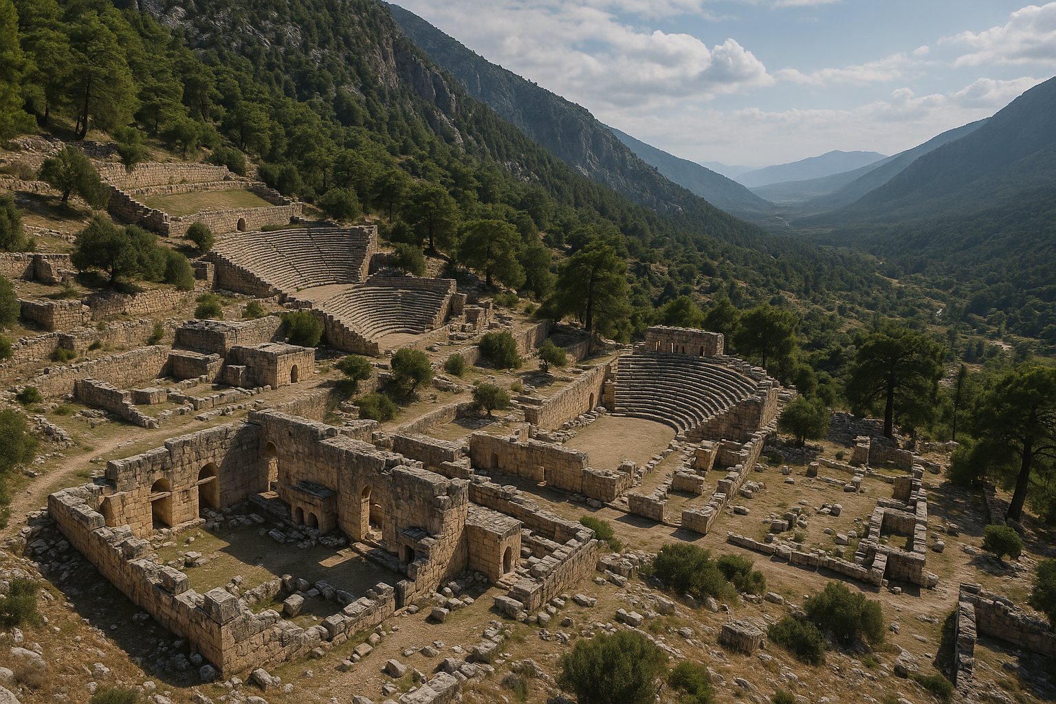
Teatr
Teatr jest częściowo wbudowany w zbocze wzgórza na niższym szczycie na zachód od głównego akropolu, zgodnie ze standardowym projektem grecko-rzymskim.
Kluczowe fakty:
- Miejsca siedzące: Około 25 rzędów siedzeń z jedną diazomą (poziomym przejściem dzielącym sektory trybun)
- Pojemność: Około 2000 widzów
- Mur oporowy: Zbudowany z małych wielobocznych bloków, zawalony na obu końcach
- Średnica: Około 50 metrów
- Stan zachowania: Dobrze zachowany; kaveа (misa trybuny) wyraźnie widoczna
- Widok: Panoramiczne widoki z górnych rzędów na otaczający krajobraz
Teatr był głównym miejscem zarówno spektakli dramatycznych, jak i zgromadzeń obywatelskich.
Akropol
Akropol wieńczy szczyt wzgórza i stanowi najstarszą zasiedloną część miasta. Otoczony jest z trzech stron murami obronnymi, które włączają naturalne wychodnie skalne w obwód obronny. Jedynie od strony południowej, gdzie naturalne bariery utrudniają dostęp, mieszkańcy nie budowali fortyfikacji. Akropol służył zarówno jako rdzeń obronny, jak i symboliczne serce miasta.
Agora licyjska
Otwarta przestrzeń w północno-zachodniej części akropolu, zidentyfikowana jako agora licyjska, służyła jako miejsce publicznych zgromadzeń i handlu we wczesnych okresach historii miasta. Sarkofag dynastyczny z dwujęzyczną inskrypcją znajduje się w pobliżu tej przestrzeni, co sugeruje, że była ona centrum elitarnej ekspozycji i obywatelskiej tożsamości.
Pomnik Iasona
Pomnik Iasona to inskrypcja znajdująca się na starożytnej drodze z wioski Yavu do akropolu Cyaneae. Dostarcza informacji o lokalnym dobroczyńcy imieniem Iason oraz o sieci dróg łączących miasto z jego terytorium -- świadectwo infrastruktury obywatelskiej, która wspierała życie miejskie i euergetyzm (publiczną hojność) oczekiwany od licyjskich elit.
Mury obronne
Fragmenty murów obronnych przetrwały wokół akropolu i wzdłuż dróg dojazdowych do miasta. Mury zbudowane są z wkomponowanymi naturalnymi wychodniami skalnymi w obwód obronny -- technika powszechna w licyjskich miastach na wzgórzach. Trojstronne umocnienia, z niezabezpieczonym od południa terenu bronionego przez naturalne ukształtowanie, świadczą o praktycznej ocenie krajobrazu przez budowniczych.
Kościoły bizantyjskie
Pozostałości kościołów chrześcijańskich z okresu bizantyjskiego świadczą o ciągłym znaczeniu miasta jako centrum religijnego i administracyjnego. Status Cyaneae jako biskupstwa (udokumentowany przez Kolba) podkreśla jego rangę w kościelnej geografii późnoantycznej Licji.
Grobowiec świątynny z kolumną jońską
Jednym z architektonicznych akcentów stanowiska jest dobrze zachowany grobowiec świątynny z pojedynczą żłobkowaną kolumną jońską w portyku. Usytuowany obok pięknych sarkofagów i grobowców domowych, tworzy jeden z najbardziej uderzających wizualnie zestawów architektury funeralnej na jakimkolwiek stanowisku licyjskim.
Prace archeologiczne
XIX wiek: Europejscy podróżnicy, w tym brytyjscy oficerowie marynarki wojennej i odkrywcy, którzy badali wybrzeże Licji, dokumentowali ruiny Cyaneae, odnotowując niezwykłą liczbę sarkofagów. Te wczesne relacje zapoznały stanowisko z europejskim środowiskiem naukowym i ugruntowały jego reputację jako „miasta sarkofagów."
1989--2001: Prof. Frank Kolb z Uniwersytetu w Tybindze (Niemcy) kierował intensywnym, systematycznym badaniem Cyaneae i jego otaczającego terytorium. Projekt ten był jednym z najbardziej gruntownych badań archeologicznych przeprowadzonych na stanowisku licyjskim.
Wkład Kolba:
- Udokumentowanie pełnego zasięgu obszaru miejskiego i otaczającego go terytorium osadniczego, w tym gospodarstw, wież strażniczych i sieci dróg
- Zapis setek sarkofagów, grobowców skalnych i elementów architektonicznych
- Ustalenie, że licyjska nazwa miasta brzmiała Xbahna na podstawie dowodów inskrypcyjnych
- Analiza rozwoju miasta od twierdzy na wzgórzu (Burg) przez klasyczne polis (Polis) do bizantyjskiego biskupstwa (Bischofssitz)
- Udokumentowanie trójstronnego systemu fortyfikacji i jego integracji z naturalnym ukształtowaniem terenu
- Opublikowanie kompleksowej monografii Burg -- Polis -- Bischofssitz: Geschichte der Siedlungskammer von Kyaneai in der Sudwestturkei (Moguncja: Philipp von Zabern, 2008)
Obecny stan: Cyaneae nie zostało formalnie wykopane w tradycyjnym sensie -- nie przeprowadzono zakrojonych na szeroką skalę prac wykopaliskowych. Wiedza archeologiczna o stanowisku pochodzi przede wszystkim z intensywnych badań powierzchniowych Kolba. Ruiny pozostają w niezrestaurowanym, w dużej mierze nienaruszonym stanie, co nadaje im szczególną autentyczność i atmosferyczną jakość głęboko docenianą przez świadomych odwiedzających. Spacer wśród setek sarkofagów w tym naturalnym krajobrazie to doświadczenie, którego żadne zrestaurowane stanowisko muzeum nie może odtworzyć.
Informacje dla odwiedzających
Dojazd
Cyaneae jest dostępne z wioski Yavu, która leży przy górskiej drodze (D-400) między Kaş a Demre. Z wioski ścieżka prowadzi pod górę do starożytnego miasta (około 20--30 minut marszu). Stanowisko nie jest formalnie oznakowane od drogi głównej, dlatego zalecane są współrzędne GPS lub lokalne wskazówki od mieszkańców Yavu.
- Z Kaş: Około 30 km na wschód drogą D-400, a następnie skręt w Yavu.
- Z Demre: Około 20 km na zachód.
- Z Antalyi: Około 200 km na południowy zachód drogą przybrzeżną D-400.
Najlepszy czas na wizytę
- Wiosna (marzec--maj): Idealny sezon. Wśród sarkofagów kwitną polne kwiaty, tworząc niezwykłe możliwości fotograficzne, temperatury są komfortowe do marszu pod górę, a widoczność doskonała.
- Jesień (wrzesień--listopad): Równie doskonały czas, z ciepłym złotym światłem podkreślającym wapienne powierzchnie sarkofagów.
- Lato (czerwiec--sierpień): Gorące; wizyty wczesnym rankiem są niezbędne. Odsłonięty szczyt wzgórza oferuje niewiele cienia poza rozproszonymi sosnami.
- Zima (grudzień--luty): Chłodna i czasami deszczowa, lecz stanowisko jest nastrojowe w zimowym świetle. Mniej odwiedzających oznacza bardziej samotne, kontemplacyjne doświadczenie.
Co zabrać
- Solidne buty do chodzenia (niezbędne przy poruszaniu się po skalistym terenie krasowym -- najważniejszy element wyposażenia)
- Co najmniej 2 litry wody na osobę (brak źródła wody na stanowisku)
- Ochrona przeciwsłoneczna (kapelusz, krem do opalania, okulary słoneczne)
- Przekąski lub lunch piknikowy (wzgórze to niezapomnialne miejsce na piknik)
- Aparat fotograficzny z dobrą wydajnością przy słabym oświetleniu (do fotografowania wnętrz grobowców i zacienionych ścian klifów)
- Przewodnik po architekturze licyjskiej, jeśli dostępny
- Kijki trekkingowe mogą być pomocne na nierównym terenie
Czas zwiedzania
- Krótka wizyta: 1,5--2 godziny (teatr, główne skupiska sarkofagów, przegląd akropolu)
- Gruntowna wizyta: 3--5 godzin (pełna eksploracja nekropolii, wszystkie główne grobowce w tym grobowiec świątynny, akropol, mury, kościoły bizantyjskie)
- Wizyta fotograficzna/badawcza: Cały dzień (same ponad 300 sarkofagów może zajmować godziny eksploracji)
Proponowana trasa spacerowa
- Zacznij od wioski Yavu i idź starożytną drogą pod górę. Zwróć uwagę na inskrypcję Pomnika Iasona po drodze -- upamiętnia ona lokalnego dobroczyńcę.
- Wejdź na teren przez obszar akropolu i podziwiaj panoramiczny widok. Zwróć uwagę na trojstronne mury obronne.
- Odwiedź agorę licyjską i sarkofag dynastyczny z jego dwujęzyczną inskrypcją licyjsko-grecką.
- Przejdź przez główne strefy nekropolii, poświęcając odpowiednio dużo czasu na badanie poszczególnych sarkofagów i ich rzeźbionych detali. Szukaj charakterystycznych wieków w kształcie „łuku gotyckiego."
- Znajdź grobowiec świątynny z jego pojedynczą żłobkowaną kolumną jońską -- jeden z architektonicznych akcentów stanowiska.
- Zejdź do teatru na jego niższym szczycie i wspinaj się na górne rzędy dla widoku. Zwróć uwagę na 25 rzędów siedzeń i diazomę.
- Eksploruj grobowce skalne na ścianach klifów.
- Odwiedź pozostałości kościołów bizantyjskich w pobliżu akropolu.
- Wróć inną ścieżką przez pola sarkofagów, by zobaczyć okazy, które przegapiłeś po drodze. Sarkofagi rozciągają się we wszystkich kierunkach, a każda ścieżka ujawnia nowe.
Uwagi dotyczące dostępności
Cyaneae to jedno z bardziej wymagających fizycznie stanowisk licyjskich do zwiedzania. Teren jest przez cały czas stromy, skalisty i nierówny, bez utrzymywanych ścieżek, poręczy ani udogodnień. Odwiedzający z ograniczoną mobilnością powinni być świadomi, że dostępne mogą być jedynie dolne partie stanowiska. Jest to miejsce dla osób komfortowo czujących się przy intensywnym marszu w terenie.
Pobliskie stanowiska
- Myra (Demre): Największe miasto w centralnej Licji, ze spektakularnymi grobowcami skalnymi wyrzeźbionymi w ścianie klifu i dobrze zachowanym teatrem rzymskim. Kościół Świętego Mikołaja (Świętego Mikołaja) również znajduje się w Demre.
- Kaş: Urokliwe nadmorskie miasteczko z licyjskimi grobowcami widocznymi w centrum miasta, teatrem Antiphellos z widokiem na morze i rejsami łódkami do Kekovy.
- Simena/Kekova: Zatopione miasto, dostępne łódką z Kaş lub Üçağız -- częściowo zanurzone licyjskie ruiny widoczne przez przezroczystą wodę.
- Aperlae: Częściowo zatopione starożytne miasto dostępne łódką.
- Szlak Licyjski: 540-kilometrowy szlak turystyczny prowadzi przez ten region; Cyaneae może zostać włączone w trasę pieszą.
Najczęściej zadawane pytania
Dlaczego Cyaneae ma tak wiele sarkofagów?
Dokładna przyczyna jest przedmiotem dyskusji, lecz prawdopodobne czynniki to: długi okres zasiedlenia (od IV wieku p.n.e. przez epokę cesarstwa rzymskiego), pozwalający pochówkom gromadzić się przez wiele stuleci; zamożna ludność, która mogła sobie pozwolić na kamienne sarkofagi; łatwo dostępny teren krasowy z wapienia ułatwiający rzeźbienie; oraz licyjski kulturowy nacisk na widoczne, monumentalne pochówki jako publiczny wyznacznik statusu rodziny i prestiżu przez pokolenia.
Co oznacza „Cyaneae"?
Nazwa pochodzi od greckiego słowa kyanos, oznaczającego „ciemnoniebieskie" -- barwę lapis lazuli. Może odnosić się do ciemnoniebieskiego wyglądu kamienia lub roślinności na stanowisku, lub może mieć starsze, przedgreckie pochodzenie. Związek z błękitem jest sugestywny wobec śródziemnomorskich widoków ze wzgórza.
Jaka jest licyjska nazwa miasta?
Według badań Franka Kolba, licyjska nazwa brzmiała Xbahna. Identyfikacja ta opiera się na dowodach inskrypcyjnych znalezionych podczas badań tybińskich.
Czy Cyaneae to to samo co Kyaneai?
Tak. „Cyaneae" to zlatynizowana forma, a „Kyaneai" to grecka forma tej samej nazwy. Obie odnoszą się do tego samego miasta. Źródła tureckie mogą również używać formy „Kyaneai."
Kim był Frank Kolb?
Frank Kolb był niemieckim historykiem starożytności i profesorem na Uniwersytecie w Tybindze. Kierował kompleksowymi badaniami Cyaneae w latach 1989--2001 i opublikował główną monografię Burg -- Polis -- Bischofssitz (2008) dotyczącą historii osadniczej stanowiska. Jego praca pozostaje definitywnym odniesieniem naukowym dla Cyaneae i jednym z najbardziej szczegółowych studiów jakiegokolwiek miasta licyjskiego.
Co oznacza „Burg -- Polis -- Bischofssitz"?
Tytuł monografii Kolba tłumaczy się jako „Twierdza -- Polis -- Siedziba biskupa." Zawiera w sobie trzy główne fazy historii Cyaneae: początki jako ufortyfikowanego osiedla na wzgórzu (Burg), klasyczny rozwój jako licyjskie polis w ramach Związku Licyjskiego (Polis) i późnoantyczną przemianę w chrześcijańskie biskupstwo (Bischofssitz).
Czym jest grobowiec świątynny z kolumną jońską?
Jednym z architektonicznych akcentów Cyaneae jest dobrze zachowany grobowiec świątynny z pojedynczą żłobkowaną kolumną jońską w portyku. Usytuowany obok pięknych sarkofagów i grobowców domowych, tworzy jeden z najbardziej uderzających wizualnie zestawów architektury funeralnej na jakimkolwiek stanowisku licyjskim. Grobowce świątynne naśladują formę świątyń greckich i były zarezerwowane dla pochówków najwyższej elity.
Czy pobiera się opłatę wstępu?
Według najbardziej aktualnych informacji nie ma formalnej opłaty wstępu. Stanowisko jest niezamknięte i nie jest oficjalnie zarządzane jako atrakcja turystyczna. Może się to zmienić w przyszłości, jeśli nastąpi formalne zagospodarowanie stanowiska.
Jak Cyaneae wypada w porównaniu z Myrą?
Myra (Demre) było największym miastem w centralnej Licji i jest bardziej uczęszczane, ze spektakularnymi grobowcami skalnymi na ścianie klifu i dużym teatrem rzymskim. Cyaneae, jako drugie co do wielkości, oferuje bardziej nastrojowe, niezrestaurowane doświadczenie ze znacznie większą liczbą sarkofagów (ponad 300 w porównaniu z grobowcami skalnymi Myry). Myra posiada udogodnienia turystyczne i kościół Świętego Mikołaja; Cyaneae oferuje samotność i autentyczność. Oba miejsca są niezbędne do zrozumienia centralnej Licji.
Pomiary architektoniczne i kluczowe dane
| Cecha | Pomiar / Szczegół |
|---|---|
| Wysokość miasta | Około 750 m n.p.m. |
| Średnica teatru | Około 50 m |
| Rzędy siedzeń w teatrze | 25 rzędów z 1 diazomą |
| Pojemność teatru | Około 2000 widzów |
| Mur oporowy teatru | Małe wieloboczne bloki, zawalone na końcach |
| Sarkofagi i grobowce | Ponad 300 udokumentowanych |
| Zakres dat sarkofagów | IV wiek p.n.e. -- okres cesarstwa rzymskiego |
| Fortyfikacje | Trzy strony obwarowane; południe niefortyfikowane (naturalne bariery) |
| Okres badań Kolba | 1989--2001 (13 sezonów) |
| Nazwa licyjska | Xbahna (ustalona przez Kolba) |
| Najbliższa wioska | Yavu |
Dowody numizmatyczne
Cyaneae uczestniczyło w mennictwie Związku Licyjskiego i później wydawało obywatelskie monety brązowe na mocy cesarskiej władzy rzymskiej. Zapis numizmatyczny odzwierciedla zmieniający się status polityczny miasta przez kilka stuleci.
| Okres | Nominał | Awers | Rewers | Uwagi |
|---|---|---|---|---|
| ok. 167--100 p.n.e. (Związek, Okres II, Seria 1) | Srebrny drachm | Wawrzynowa głowa Apollona | Kithara (lira), monogram KY | 8 skatalogowanych okazów; zdegradowany rodyjski standard wagowy |
| ok. 167--100 p.n.e. (Związek) | Nadbita obca waluta | Stempel z cytarą w nawiasach KY | Różne monety bazowe | Alternatywa dla bicia monet; wskazuje na ograniczone wyniki mennicy Cyaneae |
| n.e. 238--244 (Gordian III) | Brązowa moneta obywatelska | Popiersie Gordiana III z wieńcem laurowym | Apollon Thyrxeus stojący przed basenem ze źródłem | Emitowany po ~200-letniej przerwie w biciu monet |
Stosowanie nadbijanej obcej waluty z cytarą i literami KY jako uzupełnienie -- lub zastępstwo -- nowo bitych drachmów Związku jest wyróżniającą cechą praktyki monetarnej Cyaneae. Technika ta sugeruje, że miasto mogło mieć ograniczony dostęp do zasobów do wyrobu matryc w szczytowym okresie mennictwa Związku, mimo swojego politycznego znaczenia jako drugie co do wielkości miasto w centralnej Licji.
Około 200-letnia luka między srebrem z okresu Związku a brązami z epoki Gordiana III odpowiada szerszemu wzorcowi w całej Licji, gdzie obywatelskie bicie monet ustało pod wczesnym panowaniem rzymskim i wznowiono je dopiero w wyniku szczególnych cesarskich pozwoleń w III wieku n.e. Nie zaproponowano odpowiedniego wyjaśnienia, dlaczego licyjskie miasta otrzymały pozwolenie na ponowne bicie monet za Gordiana III, choć może to być związane z militarnymi i ekonomicznymi presją Kryzysu III wieku.
Iason z Kyaneai: drugi największy dobroczyńca Licji
Inskrypcja Pomnika Iasona, znajdująca się na starożytnej drodze z wioski Yavu do akropolu, dokumentuje jedną z najważniejszych postaci w historii Cyaneae. Iason z Kyaneai był zamożnym obywatelem z epoki rzymskiej, który pełnił funkcję Lykiarchy -- najwyższego urzędu Związku Licyjskiego, odpowiadającego prezydentowi rady federalnej.
Iasona uznano za prawdopodobnie drugą najbogatszą osobę w całej Licji, ustępującą jedynie legendarnemu filantropowi Opramoasowi z Rhodiapolis. Rywalizacja między tymi dwoma dobroczyńcami jest poświadczona w ogromnej inskrypcji Opramoas w Rhodiapolis (około 20 kolumn, 100 wierszy każda, łącznie około 36 000 liter i 7260 słów w 70 dokumentach). W tym zbiorze dokumentów Iason opisywany jest jako „wróg" Opramoas -- odniesienie do ich konkurencyjnej rywalizacji filantropijnej, a nie osobistej wrogości. Obaj mężczyźni byli chwaleni przez cesarza Antoninusa Piusa (r. 138--161 n.e.), a ich rywalizacja o wzajemne prześciganie się w hojności obywatelskiej stanowi przykład kultury euergetycznej, która podtrzymywała publiczną infrastrukturę w całym wschodnim cesarstwie.
Pomnik Iasona odnotowuje, że był on honorowany przez:
- Samego cesarza rzymskiego
- Wiele innych miast licyjskich, które skorzystały z jego hojności
- Obywateli Kyaneai
To potrójne uznanie -- cesarskie, międzymiastowe i lokalne -- wyróżnia Iasona jako postać o wyjątkowym regionalnym znaczeniu.
Licyjska terminologia funeralna w Cyaneae
Ponad 300 sarkofagów i grobowców w Cyaneae dostarcza wyjątkowego korpusu do studiowania licyjskiego słownictwa funeralnego. Inskrypcje licyjskie na stanowisku i gdzie indziej używają specyficznych terminów architektonicznych, które odpowiadają odrębnym typom grobowców:
| Termin licyjski | Typ grobowca | Opis |
|---|---|---|
| prnnawa | Grobowiec filarowy | Wysoki, wolnostojący grobowiec na monolitycznym filarze |
| nntata | Sarkofag | Grobowiec skrzyniowy na wysokiej podstawie z zakrzywionym wiekiem |
| tezi | Grobowiec skalny | Grobowiec wyrzeźbiony w ścianie klifu, często z fasadą świątynną |
| xupa | Grobowiec domowy | Grobowiec skalny imitujący domową architekturę drewnianą (termin wyłączny) |
Termin xupa jest szczególnie znaczący, ponieważ pojawia się wyłącznie w odniesieniu do skalnych grobowców domowych -- typu, który naśladuje drewnianą architekturę mieszkalną licyjskich wyżyn, z rzeźbionymi zakończeniami belek, panelami drzwiowymi i dachami szczytowymi. Rozległa nekropolia Cyaneae zawiera przykłady wszystkich czterech kategorii, czyniąc je jednym z najbardziej kompletnych stanowisk do studiowania pełnego zakresu licyjskiej architektury funeralnej.
Profil „łuku gotyckiego" wieków sarkofagów -- zakrzywiony, spiczasty kształt -- jest dziś rozumiany nie jako wybór dekoracyjny, lecz jako wierne odwzorowanie w kamieniu profilu drewnianego spichlerza lub domu, utrwalające w trwałym materiale wygląd efemerycznych budynków drewnianych, które w innym przypadku zniknęły całkowicie z zapisu archeologicznego.
Badania Kolba: metodologia i spuścizna
Tybińskie badania Cyaneae (1989--2001) wyróżniały się zakresem metodologicznym. Zamiast skupiać się wyłącznie na centrum miejskim, zespół Kolba dokumentował całe terytorium osadnicze (Siedlungskammer) -- wiejskie zaplecze podtrzymujące miasto:
- Gospodarstwa: Izolowane wiejskie domostwa z towarzyszącymi tarasami rolniczymi, tłoczniami oliwek i winogron oraz magazynami
- Wieże strażnicze: Posterunki obronne kontrolujące linie widoku przez doliny i wzdłuż dróg
- Sieć dróg: Starożytne ścieżki i brukowane odcinki dróg łączące miasto z jego terytorium i sąsiednimi poleis
- Infrastruktura wodna: Cysterny, kanały i elementy zarządzania sezonowymi strumieniami
- Miejsca kultowe: Wiejskie sanktuaria i święte gaje poza obwodem miejskim
To terytorialne podejście zaowocowało modelem licyjskich wzorców osadniczych, który wywarł wpływ na metodologię badań archeologicznych w całym wschodnim basenie Morza Śródziemnego. Monografia Kolba Burg -- Polis -- Bischofssitz (2008, Philipp von Zabern, Moguncja) pozostaje definitywnym odniesieniem, przedstawiając ewolucję miasta przez trzy fazy: ufortyfikowane wzgórze (Burg), klasyczne polis (Polis) i biskupią siedzibę bizantyjską (Bischofssitz).
Źródła i literatura uzupełniająca
- Cyaneae -- Wikipedia
- Kyaneai -- Lycian Monuments Project
- Cyaneae -- Archiqoo
- Kyaneai Research -- University of Tubingen
- Kyaneai -- Slow Travel Guide
- Kyaneai -- Holidify
- Kyaneai -- Princeton Encyclopedia of Classical Sites
- Kyaneai -- TripAdvisor
- Kolb, F. Burg -- Polis -- Bischofssitz: Geschichte der Siedlungskammer von Kyaneai in der Sudwestturkei (Moguncja: Philipp von Zabern, 2008)
- Bean, G.E. Lycian Turkey (Londyn: Ernest Benn, 1978)