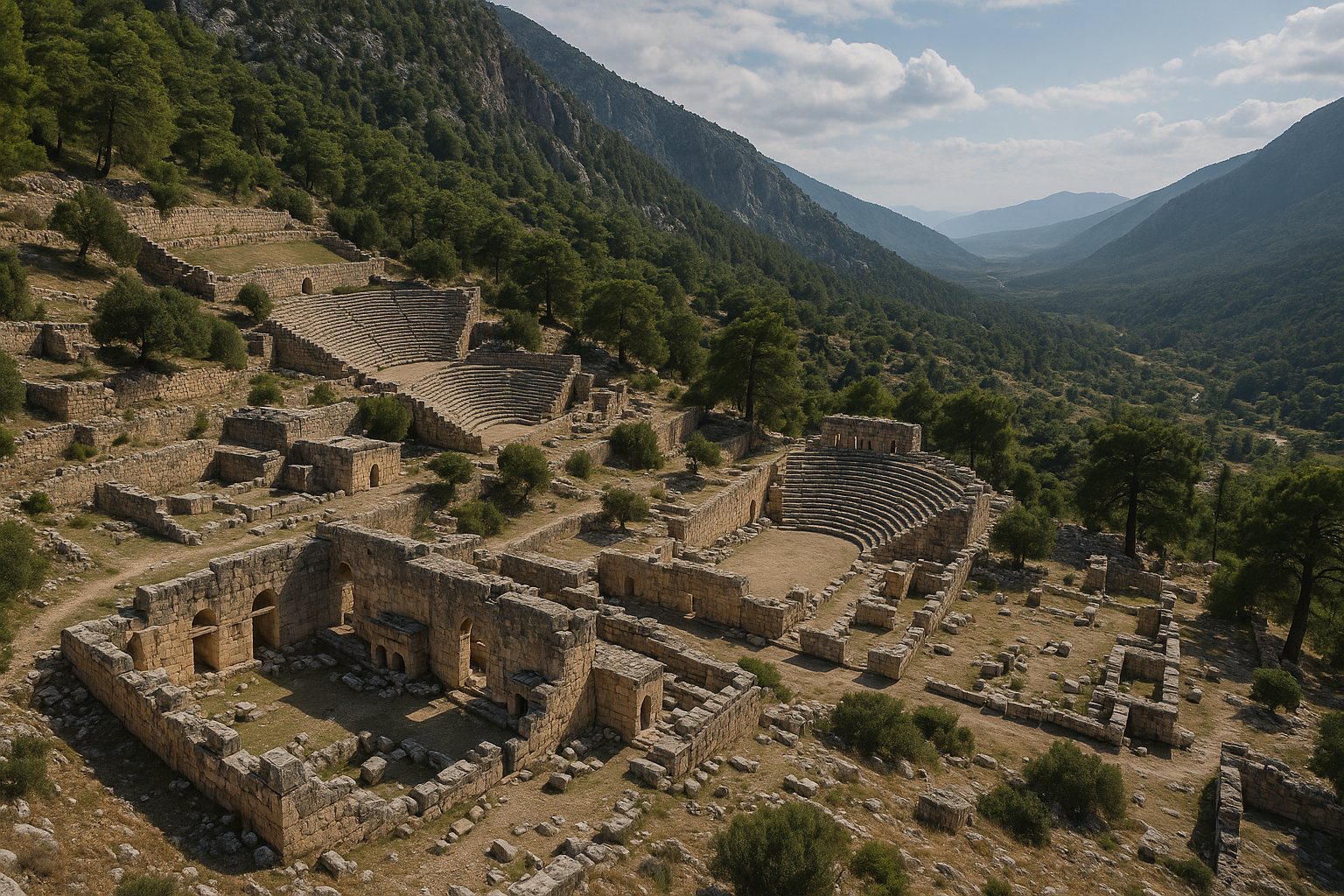
Limyra es una de las ciudades antiguas más importantes de Licia, edificada al pie del Tocak Dagi (monte Tocak) en el extremo nororiental de la llanura de Finike, en la provincia de Antalya. En la primera mitad del siglo IV a. C., el dinasta licio Pericles convirtió Limyra en su capital e impulsó un ambicioso programa edilicio que incluyó un monumental heroon (tumba heroica) decorado con cariátides. La ciudad alcanzó después renombre en época romana como el lugar donde Cayo César, nieto adoptivo del emperador Augusto, murió en el 4 d. C., conmemorado por un gran cenotafio con 60 metros de frisos en relieve. Con más de 400 tumbas excavadas en la roca distribuidas en cinco necrópolis, un teatro de 6.000 asientos, termas romanas, una calle porticada y el cercano puente de Limyra --uno de los puentes de arco rebajado más antiguos del mundo--, Limyra es un yacimiento de extraordinaria riqueza arqueológica que ha sido excavado de manera continua por el Instituto Arqueológico Austriaco desde 1969.
Tabla de contenidos
- Por qué importa Limyra
- Geografía y emplazamiento
- Cronología histórica
- Principales monumentos
- Trabajos arqueológicos
- Información para el visitante
- Preguntas frecuentes
- Fuentes y lecturas complementarias
Por qué importa Limyra
Limyra no es simplemente otra ruina antigua a lo largo de la costa turca. Es una ciudad que desempeñó un papel central en algunas de las transiciones políticas más significativas de la Anatolia antigua. Estas son las razones por las que importa:
-
Capital de un unificador licio. A comienzos del siglo IV a. C., el dinasta Pericles de Limyra utilizó esta ciudad como base para su intento de unificar la Liga Licia -- una federación de ciudades-estado independientes. Su heroon (tumba monumental) en Limyra es uno de los mejores ejemplos de arquitectura funeraria licia y refleja sus ambiciones políticas.
-
Una muerte que marcó la sucesión romana. En el 4 d. C., Cayo César --el hijo adoptivo y heredero designado del emperador Augusto-- murió en Limyra a causa de las heridas recibidas durante el asedio de Artagira, en Armenia. Su muerte desencadenó una crisis de sucesión que llevó finalmente a Tiberio a convertirse en emperador. El cenotafio construido en Limyra es uno de los monumentos funerarios romanos más impresionantes de Asia Menor.
-
La mayor necrópolis licia. Con aproximadamente 400 tumbas excavadas en la roca distribuidas en cinco necrópolis distintas, Limyra posee la mayor concentración de tumbas de cualquier ciudad licia. Estas tumbas abarcan siglos e incluyen tumbas de tipo casa, tumbas en pilar, sarcófagos y cámaras rupestres en pared de acantilado.
-
Excavación continua y prolongada. El Instituto Arqueológico Austriaco (OAI) excava Limyra desde 1969, lo que la convierte en una de las ciudades licias mejor estudiadas. El sostenido programa de investigación ha producido publicaciones detalladas y ha transformado nuestra comprensión del urbanismo licio.
-
Maravilla de la ingeniería: el puente de Limyra. El puente antiguo cercano a Limyra, que cruza el río Alakir Cayi a lo largo de más de 360 metros sobre 26 arcos rebajados, es uno de los puentes de arco rebajado más antiguos del mundo y la mayor estructura de ingeniería civil antigua de la región.
Geografía y emplazamiento
Limyra se encuentra aproximadamente a 9 kilómetros al noreste de Finike (la antigua Phoenicus), en la provincia de Antalya, al pie de los montes Bey, donde se unen con la fértil llanura de Finike.
| Característica | Detalle |
|---|---|
| Región antigua | Licia |
| Ubicación moderna | Turunova, distrito de Finike, provincia de Antalya |
| Altitud | Acrópolis a ~350 m; ciudad baja cerca del nivel del mar |
| Localidad moderna más cercana | Finike (~9 km al suroeste) |
| Río | Alakir Cayi (antiguo Arycandus/Limyros) |
| Montaña | Tocak Dagi (monte Tocak) |
| Terreno | Ladera montañosa que desciende a la llanura aluvial |
El yacimiento está situado de manera espectacular: la acrópolis corona un escarpado espolón rocoso del Tocak Dagi, mientras que la ciudad baja se extiende por la llanura. Entre ambas, la ladera de la montaña está horadada por tumbas excavadas en la roca que confieren a Limyra su carácter visual distintivo: una pared de acantilado salpicada de cientos de oscuras aberturas rectangulares.
El río Alakir Cayi (identificado con el antiguo Limyros o Arycandus) fluye por la llanura cerca de la ciudad, proporcionando agua para la agricultura y alimentando los manantiales que brotan al pie de la montaña. Estos manantiales fueron un elemento importante de la ciudad antigua, y los sistemas de gestión del agua (canales, cisternas, fuentes) son visibles por todas las ruinas.
La llanura de Finike es una de las zonas más fértiles de la costa licia, productora de cítricos, aceitunas y verduras. En la Antigüedad, esta riqueza agrícola fue el fundamento económico de la prosperidad de Limyra.
Cronología histórica
Asentamiento temprano (antes del siglo V a. C.)
La evidencia más antigua de habitación en Limyra se remonta al menos al siglo V a. C., cuando aparecen por primera vez las inscripciones en lengua licia. El lugar probablemente estuvo ocupado antes, pero los restos preclásicos están enterrados bajo construcciones posteriores. El nombre «Limyra» aparece en licio como Zemuri.
Período clásico: Pericles y la Liga Licia (c. 380-360 a. C.)
La figura política más importante asociada con Limyra es el dinasta Pericles (que no debe confundirse con el famoso estadista ateniense). A comienzos del siglo IV a. C., Pericles hizo de Limyra su capital y lanzó una campaña para unificar las ciudades de Licia bajo su liderazgo. Acuñó monedas, construyó un enorme heroon en la ladera bajo la acrópolis y transformó Limyra en un centro de poder político.
El esfuerzo unificador de Pericles fue finalmente truncado por la intervención persa. El sátrapa persa Mausolo de Caria (el mismo Mausolo cuya tumba se convirtió en una de las Siete Maravillas) presionó a las ciudades licias para que resistieran la centralización de Pericles, y su proyecto se derrumbó hacia el 360 a. C..
Período helenístico (siglos III-I a. C.)
Tras las conquistas de Alejandro Magno, Licia pasó por manos de varios reinos sucesores: el Egipto ptolemaico, el Imperio seléucida y el Reino de Pérgamo. Limyra continuó funcionando como ciudad importante dentro de la Liga Licia, el notablemente democrático sistema federal que gobernó Licia. El monumento del Ptolemaion en Limyra data del período de influencia ptolemaica en el siglo III a. C.
Período romano (siglo I a. C. -- siglo IV d. C.)
Bajo el dominio romano, Licia mantuvo inicialmente cierto grado de autonomía a través de la Liga Licia. En el 43 d. C., el emperador Claudio disolvió la Liga e incorporó Licia como provincia romana. Limyra prosperó bajo la administración romana: se construyó el teatro (con capacidad para ~6.000), se levantaron las termas romanas y se trazó una calle porticada.
El acontecimiento más dramático de la época romana fue la muerte de Cayo César el 21 de febrero del 4 d. C.. Cayo, hijo adoptivo de Augusto y su heredero designado, regresaba de una campaña militar en Armenia cuando murió en Limyra a causa de las heridas recibidas durante el asedio de la fortaleza armenia de Artagira. Se construyó un monumental cenotafio (tumba vacía) en Limyra en su honor, con frisos en relieve que se extienden aproximadamente 60 metros y representan escenas de su vida.
Período bizantino (siglos IV-VII d. C.)
Durante la era bizantina, Limyra se convirtió en sede de un obispo (un centro episcopal), confirmando su continuada importancia. Se construyeron iglesias por toda la ciudad y se levantó un palacio del obispo. La acrópolis fue refortificada con nuevas murallas que incorporaban estructuras anteriores. La ciudad continuó habitada al menos hasta el siglo VII, cuando las incursiones árabes alteraron los patrones de poblamiento por todo el sur de Anatolia.
Principales monumentos
Heroon de Pericles
El Heroon de Pericles es el monumento arquitectónicamente más ambicioso de Limyra y una de las obras maestras del arte funerario licio.
- Ubicación: En la ladera de la montaña, justo debajo de la acrópolis
- Fecha: c. 380-360 a. C.
- Forma: Una tumba monumental sobre un alto podio, que combina elementos arquitectónicos licios y griegos
- Decoración: La tumba presentaba cariátides -- figuras femeninas que servían como soportes arquitectónicos (columnas en forma de mujer). Importantes fragmentos de las cariátides se exhiben hoy en el Museo Arqueológico de Antalya.
- Relieves: El heroon estaba decorado con frisos en relieve que representan escenas de las campañas militares y los logros políticos de Pericles
- Significación: La combinación de la tradición funeraria licia con el vocabulario arquitectónico griego en el heroon refleja la doble identidad de Pericles: un gobernante licio que adoptó formas culturales griegas para legitimar su autoridad política
El heroon fue parcialmente destruido en la Antigüedad, posiblemente de forma deliberada por rivales políticos o a causa de un desastre natural. Muchos de sus mejores elementos escultóricos se recuperaron durante las excavaciones austriacas y se encuentran hoy entre los tesoros del Museo de Antalya.
Cenotafio de Cayo César
El Cenotafio de Cayo César es una tumba vacía monumental construida en honor del nieto adoptivo del emperador Augusto.
- Fecha: Poco después del 4 d. C.
- Tipo: Cenotafio (monumento conmemorativo; los restos reales de Cayo fueron devueltos a Roma)
- Frisos en relieve: El cenotafio está decorado con paneles en relieve que se extienden aproximadamente 60 metros y representan escenas de la vida y la carrera militar de Cayo César
- Ubicación: En la zona de la ciudad baja
- Contexto histórico: Cayo César murió en Limyra el 21 de febrero del 4 d. C. a causa de las heridas recibidas durante el asedio de Artagira, en Armenia. Su muerte fue una catástrofe política para Augusto, que había preparado a Cayo como su sucesor. El cenotafio de Limyra sirvió a la vez como monumento conmemorativo y declaración política, afirmando la conexión imperial con esta ciudad licia.
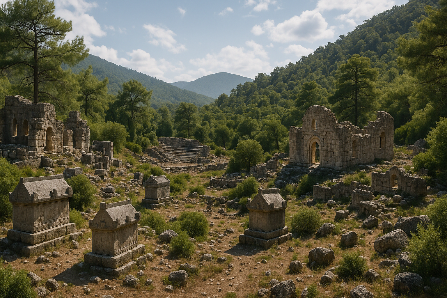
Tumbas excavadas en la roca y necrópolis
El rasgo visualmente más impactante de Limyra es su vasta necrópolis: aproximadamente 400 tumbas excavadas en la roca distribuidas en cinco zonas funerarias distintas:
- Necrópolis del acantilado (ladera de la montaña): El grupo más espectacular, con tumbas talladas directamente en la pared del acantilado del Tocak Dagi. Van desde simples cámaras rectangulares hasta elaboradas tumbas de varias salas con fachadas arquitectónicas.
- Necrópolis occidental: Contiene tumbas en pilar y sarcófagos
- Necrópolis septentrional: Presenta tumbas licias de tipo casa
- Necrópolis meridional: Tipos de tumbas mixtos de diversos períodos
- Necrópolis de la ciudad baja: Sarcófagos y tumbas construidas de época romana
Las tumbas abarcan un período que va del siglo V a. C. a la época romana e incluyen ejemplos de todos los principales tipos de tumbas licias: tumbas de cámara excavadas en la roca, tumbas en pilar, tumbas de tipo casa y sarcófagos. Muchas presentan inscripciones en lengua licia que proporcionan valiosa información sobre los nombres, títulos y relaciones familiares de los difuntos.
Teatro
El teatro romano de Limyra está construido en la pendiente natural de la montaña, en el lado sur de la ciudad.
- Capacidad: Aproximadamente 6.000 espectadores
- Fecha: Período romano (siglos I-II d. C.)
- Conservación: La cávea (graderío) está bien conservada, con muchas filas de asientos intactas
- Características: Orquesta semicircular, edificio escénico (parcialmente conservado) y túneles de acceso (vomitoria)
- Vistas: El teatro domina vistas panorámicas sobre la llanura de Finike y hacia el mar
Ptolemaion
El Ptolemaion es una estructura monumental que data del siglo III a. C., durante el período de influencia ptolemaica (egipcia) sobre Licia.
- Función: Probablemente un monumento conmemorativo u honorífico dedicado a un gobernante ptolemaico
- Ubicación: En la ciudad baja
- Significación: El Ptolemaion documenta la relación política entre Limyra y el Egipto ptolemaico durante el período helenístico
Termas romanas y calle porticada
La infraestructura cívica de época romana en Limyra incluye:
- Termas (Thermae): Un sustancial complejo termal con sistema de hipocausto (calefacción bajo el suelo), salas frías y calientes y canales de suministro de agua
- Calle porticada: Una vía pavimentada flanqueada por columnas que conectaba los principales edificios cívicos, característica habitual de las prósperas ciudades romanas de Asia Menor
Iglesias bizantinas y palacio del obispo
En Limyra se han identificado varias iglesias del período bizantino, junto con un palacio del obispo que confirma el estatus de la ciudad como centro episcopal.
- Iglesias: Múltiples iglesias de planta basilical con ábsides, algunas construidas sobre o cerca de estructuras paganas anteriores
- Palacio del obispo: Un complejo administrativo y residencial para el obispo local
- Murallas fortificadas: Murallas defensivas de época bizantina en la acrópolis, que incorporan sillería romana y licia anterior
Puente de Limyra
El puente de Limyra (también llamado puente cercano a Limyra) es uno de los logros de ingeniería más notables del mundo antiguo.
- Longitud: Aproximadamente 360 metros (1.181 pies)
- Arcos: 26 arcos rebajados -- un uso temprano y sofisticado de la forma del arco rebajado
- Fecha: Período romano tardío (posiblemente siglo IV d. C.)
- Río: Cruza el Alakir Cayi (antiguo Arycandus/Limyros)
- Significación: Uno de los puentes de arco rebajado más antiguos del mundo. A diferencia de los arcos semicirculares completos, los arcos rebajados son más planos, requieren menos material y permiten que el puente sea más bajo y más largo. Esta innovación de ingeniería se convertiría más tarde en la forma dominante de construcción de puentes en los períodos medieval y moderno.
Templo de Zeus
En un descubrimiento arqueológico notable, el Templo de Zeus de Limyra se localizó finalmente tras 43 años de búsqueda. El templo, datado en el período clásico, había sido descrito en fuentes antiguas, pero su ubicación exacta dentro de la ciudad había eludido a los excavadores durante décadas. Su eventual identificación añadió un importante monumento religioso al ya impresionante inventario de estructuras de Limyra.
Trabajos arqueológicos
Limyra ha sido objeto de uno de los programas de excavación más prolongados y productivos de la arqueología licia.
Excavaciones del Instituto Arqueológico Austriaco (1969-actualidad)
El Instituto Arqueológico Austriaco (Osterreichisches Archaologisches Institut, OAI) inició las excavaciones en Limyra en 1969 bajo la dirección de Jurgen Borchhardt. El proyecto ha continuado durante más de cinco décadas, convirtiéndolo en uno de los programas de investigación arqueológica más sostenidos en Turquía.
Las figuras clave en la historia de las excavaciones incluyen:
- Jurgen Borchhardt -- director fundador de la excavación de Limyra
- Martin Seyer -- posterior director de las excavaciones
- Kudret Sezgin -- responsable de las excavaciones de Limyra en años recientes, en coordinación con el equipo austriaco
Principales descubrimientos
A lo largo de las décadas, la excavación austriaca ha sacado a la luz y documentado:
- El Heroon de Pericles y sus esculturas de cariátides
- El Cenotafio de Cayo César y sus extensos frisos en relieve
- Cientos de tumbas excavadas en la roca con inscripciones
- El teatro, las termas y los edificios cívicos de la ciudad romana
- Iglesias bizantinas y el palacio del obispo
- El recientemente descubierto Templo de Zeus
- Extensa evidencia numismática que documenta la historia económica de Limyra
Publicaciones
La excavación de Limyra ha producido un amplio registro de publicaciones, que incluye informes anuales de excavación, estudios especializados de monumentos individuales y análisis exhaustivos de las inscripciones funerarias, la cerámica y los restos arquitectónicos.
Información para el visitante
Cómo llegar
- Desde Finike: Conduzca hacia el noreste aproximadamente 9 km hacia Turunova. El yacimiento está señalizado desde la carretera principal.
- Desde Antalya: Tome la autovía D-400 hacia el oeste a lo largo de la costa pasando por Kemer y Kumluca hasta Finike (aproximadamente 150 km) y luego siga las indicaciones locales hasta Limyra.
- Desde Kas/Kalkan: Conduzca hacia el este por la D-400 hasta Finike (~85 km desde Kas) y luego al norte hasta Limyra.
Qué esperar
- Entrada: Pequeña tarifa de admisión (consulte las tarifas vigentes)
- Instalaciones: Servicios básicos cerca de la entrada; no hay servicios extensos en el yacimiento
- Terreno: La ciudad baja es relativamente llana, pero llegar a las tumbas rupestres y a la acrópolis requiere ascender por senderos rocosos
- Señalización: Paneles informativos en las principales estructuras
Duración recomendada de la visita
- Solo ciudad baja (teatro, termas, cenotafio): 1,5-2 horas
- Incluyendo tumbas rupestres y ladera de la montaña: 3-4 horas
- Visita completa con acrópolis: Medio día
- Visita fotográfica/de investigación: Día completo
Mejor momento para visitar
- Primavera (marzo-mayo): Ideal -- temperaturas agradables, flores silvestres, excelente luz
- Otoño (septiembre-noviembre): Clima agradable, menos turistas
- Verano: Muy caluroso, especialmente en la ladera expuesta de la montaña. Visite a primera hora de la mañana.
- Invierno: Clima costero suave; algunas áreas pueden estar embarradas
Visitas combinadas
Limyra se combina excelentemente con:
- Arykanda -- impresionante ciudad licia en una ladera de montaña (~30 km al norte)
- Mira y la iglesia de San Nicolás (Demre) -- importantes tumbas rupestres licias e iglesia bizantina (~45 km al oeste)
- Finike -- ciudad costera con mercado local y puerto
- Olympos y Quimera -- ciudad antigua y llamas eternas naturales (~60 km al este)
- Museo Arqueológico de Antalya -- alberga los principales hallazgos de Limyra, incluidas las cariátides del heroon de Pericles
Consejos
- Comience por el teatro y la ciudad baja, y luego ascienda hacia las tumbas rupestres
- Lleve agua, especialmente si planea subir a la acrópolis
- Las tumbas rupestres son más fotogénicas con la luz de la mañana, cuando la pared del acantilado está iluminada
- Se recomienda encarecidamente la visita al Museo de Antalya como complemento, ya que muchas de las mejores piezas escultóricas de Limyra están allí expuestas
- El puente de Limyra se encuentra fuera del yacimiento principal; pregunte localmente las indicaciones
Preguntas frecuentes
¿Quién fue Pericles de Limyra?
Pericles fue un dinasta (gobernante) licio de comienzos del siglo IV a. C. que hizo de Limyra su capital e intentó unificar las ciudades de Licia bajo su liderazgo. No tiene relación con el famoso estadista ateniense Pericles. Su monumental heroon (tumba) en Limyra es uno de los mejores ejemplos de arquitectura funeraria licia, con esculturas de cariátides hoy en el Museo de Antalya.
¿Por qué murió Cayo César en Limyra?
Cayo César, nieto adoptivo y heredero del emperador Augusto, fue herido durante el asedio de la fortaleza armenia de Artagira en el 3 d. C.. Mientras regresaba a Roma por mar, su estado empeoró y murió en Limyra el 21 de febrero del 4 d. C.. Su muerte fue un acontecimiento político mayor, ya que alteró los planes sucesorios de Augusto y eventualmente llevó a que Tiberio se convirtiera en el siguiente emperador.
¿Cuántas tumbas hay en Limyra?
Limyra tiene aproximadamente 400 tumbas excavadas en la roca distribuidas en cinco necrópolis, lo que la convierte en la mayor concentración de tumbas de cualquier ciudad licia. Las tumbas incluyen cámaras rupestres, tumbas en pilar, tumbas de tipo casa y sarcófagos, abarcando desde el siglo V a. C. hasta el período romano.
¿Es el puente de Limyra parte del yacimiento arqueológico principal?
El puente de Limyra se encuentra fuera del yacimiento principal, cruzando el río Alakir Cayi en la llanura cercana a la ciudad. Requiere una visita separada. Con 360 metros de longitud y 26 arcos rebajados, es uno de los puentes antiguos más notables del mundo.
¿Puedo ver las cariátides del Heroon de Pericles?
Los mejores fragmentos de las cariátides del heroon se exhiben en el Museo Arqueológico de Antalya, no en el propio yacimiento. En Limyra puede ver los cimientos y la plataforma del heroon en la ladera de la montaña, bajo la acrópolis.
¿Continúan las excavaciones?
Sí. El Instituto Arqueológico Austriaco ha estado excavando Limyra de manera continua desde 1969, lo que la convierte en uno de los proyectos de excavación de más larga duración en Turquía. Los trabajos recientes han incluido el descubrimiento del Templo de Zeus tras 43 años de búsqueda.
Mediciones arquitectónicas y datos estructurales
La siguiente tabla resume las dimensiones verificadas de los principales monumentos de Limyra tal como las ha registrado el Instituto Arqueológico Austriaco a lo largo de múltiples campañas de excavación.
| Monumento | Dimensiones / Medida clave | Fecha de construcción |
|---|---|---|
| Heroon de Pericles -- podio | 10,4 x 6,8 m de base; altura del podio 3,8 m | c. 370-360 a. C. |
| Heroon de Pericles -- terraza | 20 x 20 m (tallada directamente en la roca madre) | c. 370-360 a. C. |
| Hyposorion del heroon (cámara funeraria) | 10 x 7 m, entrada orientada al sur | c. 370-360 a. C. |
| Cávea del teatro | Aprox. 65 m de diámetro; capacidad para 6.000 asientos | Siglos I-II d. C. |
| Puente de Limyra -- longitud total | 360 m (1.181 pies) sobre 26 arcos rebajados | Romano tardío, posiblemente siglo IV d. C. |
| Puente de Limyra -- anchura del pilar | 2,10 m (6,9 pies) | Romano tardío |
| Puente de Limyra -- luz libre del arco | 10,65 m (34,9 pies); luz habitual 12,75 m | Romano tardío |
| Puente de Limyra -- relación luz/flecha | 5,3:1 (mayor arco 6,4:1) | Romano tardío |
| Templo de Zeus -- fachada frontal | 15 m de ancho | Período clásico |
| Cenotafio de Cayo César -- frisos en relieve | Aprox. 60 m de longitud total | Poco después del 4 d. C. |
El Heroon de Pericles empleaba cuatro cariátides en cada una de sus fachadas norte y sur (ocho en total), que servían como elementos sustentadores del techo en lugar de columnas convencionales. Los fragmentos de cariátides recuperados durante la excavación se encuentran hoy entre los preciados fondos del Museo Arqueológico de Antalya.
Evidencia numismática de Limyra
La acuñación proporciona un registro crítico de las afiliaciones políticas y la vitalidad económica de Limyra a lo largo de los siglos. La siguiente tabla presenta las principales categorías numismáticas recuperadas durante la excavación.
| Período | Tipo de moneda | Rasgos destacados |
|---|---|---|
| Clásico (siglo IV a. C.) | Emisiones dinásticas de Pericles | Pericles representado como soberano; leyendas en escritura licia |
| Helenístico (167-81 a. C.) | Dracmas de la Liga Licia acuñadas en Limyra | Patrón rodio ligero; peso aproximado 2,7 g |
| Helenístico tardío | Dracmas de la Liga y denarios | Retratos de Augusto y Claudio en emisiones posteriores |
| Romano imperial | Emisiones cívicas de bronce | Tipos provinciales estándar |
| Romano tardío / Dominado (285-491 d. C.) | Acuñación imperial de bronce | Casi el 50% de todas las monedas excavadas datan de este período |
| Bizantino (siglos V-VII d. C.) | Pequeñas denominaciones de bronce | 255 monedas recuperadas de contextos de los siglos V-VII |
| Islámico (siglo VII d. C. y posterior) | Bronce y plata islámica temprana | Cantidades significativas halladas, especialmente durante la campaña de 2019 |
Un exhaustivo estudio numismático realizado durante las campañas de excavación de 2016-2022 catalogó aproximadamente 1.000 monedas en total. El predominio de la acuñación del período del Dominado (de Diocleciano a Zenón, 285-491 d. C.) demuestra que Limyra siguió siendo un centro urbano activo hasta bien entrada la época romana tardía, contradiciendo las suposiciones anteriores sobre un rápido declive posclásico.
Cronología de excavaciones y campañas clave
| Año(s) | Director / Equipo | Actividades y descubrimientos clave |
|---|---|---|
| 1966 | Jurgen Borchhardt (prospección) | Descubrimiento de los restos del Heroon de Pericles en la ladera de la montaña |
| 1969 | Borchhardt / Instituto Arqueológico Austriaco | Comienzan las excavaciones formales; documentación sistemática de las necrópolis |
| 1969-años 2000 | Borchhardt y sucesores | Excavación del teatro, el cenotafio, las termas, la calle porticada y las iglesias |
| Años 2010 | Martin Seyer / OAI | Continuación del trabajo en el palacio del obispo y las fortificaciones bizantinas |
| 2016-2019 | OAI / coordinación de Kudret Sezgin | Análisis XRF de 40 objetos de metalistería; 25 escorias y fragmentos de horno confirman la metalurgia primaria del hierro en el yacimiento |
| 2019 | Campaña del OAI | Grandes cantidades de monedas islámicas recuperadas; los estudios geoarqueológicos revelan la fundación de la ciudad sobre antiguos sedimentos lacustres |
| 2022 | Campaña del OAI | Primer estudio numismático exhaustivo del material de 2016-2022 (~1.000 monedas catalogadas) |
| 2023-2024 | Campaña del OAI | Descubrimiento del Templo de Zeus (fachada frontal de 15 m de ancho) tras 43 años de búsqueda |
Las investigaciones geoarqueológicas han revelado que la ciudad baja de Limyra se construyó sobre antiguos sedimentos lacustres, un hallazgo que influye significativamente en la comprensión de la elección original del emplazamiento de la ciudad y los posteriores retos de planificación urbana. El subsuelo pantanoso requirió una cuidadosa ingeniería para la construcción de cimientos y el drenaje, lo que explica la amplia infraestructura de gestión del agua visible por todas las ruinas.
Evidencia metalúrgica e industrial
El análisis científico mediante espectrometría XRF portátil de 40 objetos de metalistería de Limyra --incluidos 25 escorias, lupias y fragmentos de horno-- ha confirmado la existencia de metalurgia primaria del hierro en el yacimiento. Esto significa que Limyra no solo importaba productos férreos acabados, sino que fundía mineral de hierro localmente, lo que indica un nivel de autosuficiencia industrial inusual para una ciudad costera licia. Las instalaciones de metalurgia del hierro parecen datar principalmente de los períodos romano y tardoantiguo, cuando la población y la infraestructura de la ciudad alcanzaron su apogeo.
Fuentes y lecturas complementarias
- Borchhardt, J. et al. Limyra: Zentrum Lykiens. Publicaciones del Instituto Arqueológico Austriaco.
- Limyra -- Wikipedia
- Limyra -- Turkish Archaeological News
- Limyra -- Lycian Monuments
- Limyra Archaeological Site -- Turkish Museums
- Limyra Ancient City -- Livius
- Limyra Bridge -- Wikipedia
- Temple of Zeus discovery at Limyra -- Arkeonews
Comprender la Liga Licia
La importancia histórica de Limyra no puede entenderse sin conocer la Liga Licia: el sistema federal que gobernó Licia y que se considera uno de los ejemplos más sofisticados de gobierno representativo del mundo antiguo.
Estructura y funcionamiento
La Liga Licia era una federación de ciudades-estado independientes que compartían instituciones comunes manteniendo la autonomía local. Sus rasgos clave incluían:
- Representación proporcional: A las ciudades se les asignaba peso de voto (1, 2 o 3 votos) según su tamaño e importancia
- Asamblea común (synedrion): Se reunía periódicamente para decidir asuntos de guerra, paz, impuestos y política exterior
- Magistrado electo (Liciarca): Un líder elegido por la asamblea para encabezar la federación
- Tesorería y acuñación comunes: Instituciones financieras compartidas que financiaban proyectos colectivos
- Sistema judicial: Tribunales federales que resolvían disputas entre las ciudades miembros
Los Padres Fundadores estadounidenses estudiaron la Liga Licia como modelo al diseñar la Constitución de Estados Unidos. Alexander Hamilton la mencionó específicamente en el Federalista N.º 16 como ejemplo de gobierno federal eficaz.
El desafío de Pericles a la Liga
Cuando Pericles de Limyra intentó unificar Licia bajo su gobierno personal a comienzos del siglo IV a. C., estaba efectivamente intentando reemplazar el sistema federal por una monarquía. Su campaña fue ambiciosa: acuñó monedas que lo mostraban como soberano, construyó un enorme heroon en Limyra y conquistó o coaccionó a varias ciudades licias para que se sometieran.
La resistencia a la centralización de Pericles --respaldada por el sátrapa persa Mausolo-- preservó en última instancia el carácter federal de la Liga. Tras el derrumbe del proyecto de Pericles hacia el 360 a. C., la Liga continuó funcionando durante siglos, sobreviviendo incluso al Imperio persa y subsistiendo bajo el dominio helenístico y romano hasta que el emperador Claudio la disolvió en el 43 d. C.
El papel de Limyra en la Liga
Dentro de la Liga Licia, Limyra fue una de las ciudades principales con un peso de voto significativo. Su posición en el extremo oriental de Licia le confería importancia estratégica como puerta de entrada entre Licia y las regiones vecinas de Panfilia y Cilicia.
Las tumbas rupestres: una guía de la arquitectura funeraria licia
Las más de 400 tumbas excavadas en la roca de Limyra representan prácticamente todos los tipos de arquitectura funeraria licia. Comprender estos tipos ayuda a los visitantes a apreciar la extraordinaria variedad de la necrópolis.
Tumbas de tipo casa
La forma más característica de tumba licia es la tumba de tipo casa, que reproduce en piedra la apariencia de una casa de madera. Estas tumbas presentan:
- Vigas de madera imitadas talladas en piedra
- Fachadas estilo cabaña de troncos que reproducen la arquitectura en madera
- Techos planos o a dos aguas que imitan los edificios residenciales
- Cámaras interiores para enterramientos múltiples
La tumba de tipo casa refleja la creencia licia de que los muertos necesitaban una morada apropiada en el más allá, modelada según los hogares que habitaban en vida.
Tumbas en pilar
Las tumbas en pilar (o tumbas torre) consisten en una cámara funeraria elevada sobre un alto pilar de piedra, que sitúa al difunto por encima del nivel del suelo. Se encuentran entre los monumentos licios visualmente más impactantes. La altura del pilar pudo haber reflejado el estatus social del ocupante: cuanto más alta la tumba, más importante la persona.
Tumbas de cámara excavadas en la roca
Las tumbas en la pared del acantilado de Limyra son cámaras talladas directamente en la roca caliza. Van desde simples aberturas rectangulares hasta elaborados complejos de varias salas con fachadas talladas. Algunas presentan:
- Fachadas arquitectónicas que imitan frontales de templos
- Tallas en relieve que representan al difunto, a familiares o escenas mitológicas
- Inscripciones en lengua licia que proporcionan información biográfica
- Diseños de múltiples cámaras que sugieren tumbas familiares utilizadas durante generaciones
Sarcófagos
Por las necrópolis de Limyra se encuentran sarcófagos exentos (ataúdes de piedra). Los sarcófagos licios suelen presentar una tapa de arco apuntado distintiva (forma ojival) que es exclusiva de Licia. Algunos están elaboradamente decorados con tallas en relieve.
Agua y manantiales: la vida oculta de la ciudad
Uno de los rasgos más notables de Limyra es su relación con el agua. Los manantiales que emergen al pie del Tocak Dagi proporcionaron a la ciudad un suministro de agua fiable durante todo el año, una ventaja crucial en el clima mediterráneo semiárido.
Estos manantiales no eran meros recursos prácticos; también eran sagrados. En la religión licia, los manantiales y las fuentes de agua se asociaban a menudo con la presencia divina, y es probable que algunos de los manantiales de Limyra fueran venerados como lugares sagrados antes de que tuviera lugar cualquier desarrollo urbano.
Los romanos canalizaron el agua de los manantiales en una elaborada red de infraestructura que incluía:
- Acueductos y canales que conducían el agua a los edificios públicos
- Fuentes (ninfeos) que proporcionaban acceso público al agua
- Termas que requerían grandes volúmenes de agua caliente
- Sistemas de drenaje que gestionaban el exceso de agua y las aguas residuales
Hoy en día, los visitantes pueden ver aún el agua fluir por partes de la ciudad antigua, creando un exuberante entorno verde que contrasta con la árida ladera superior.