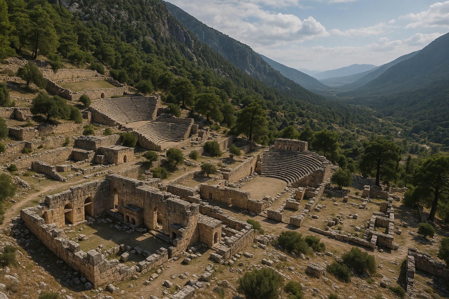
سيمينا مستوطنة ساحلية ليقية قديمة صغيرة ولكنها آسرة، تتربّع على منحدر صخري مطلّ على خليج كيكوفا في الجزء الجنوبي الغربي من الساحل المتوسطي التركي. تُعرف اليوم بـكاليكوي ("قرية القلعة")، وهي من المواقع المأهولة النادرة في تركيا التي لا يمكن الوصول إليها إلا بحرًا أو سيرًا على الأقدام -- لا طريق برّية تصلها. تتوّج القرية قلعة صليبية من العصور الوسطى تضمّ بقايا حصن ليقي قديم، وتحتوي على أصغر مسرح معروف في ليقيا، منحوت في الصخر الحيّ بـ7 صفوف من المقاعد تستوعب نحو 300 متفرّج. على الجانب الآخر من الخليج، تتلألأ أطلال المدينة القديمة دوليخيستي في جزيرة كيكوفا تحت مياه فيروزية شفّافة، مما يُبدع واحدة من أكثر المشاهد الأثرية الساحلية أيقونيةً في البحر المتوسط. كانت سيمينا عضوًا في الرابطة الليقية، إحدى أولى الديمقراطيات الفيدرالية في العالم القديم، وغدا تابوتها اللقيي شبه المغمور في مياه الميناء الصورة المعرِّفة لمنطقة كيكوفا بأسرها.
جدول المحتويات
- لماذا تُعدّ سيمينا مهمة
- الجغرافيا والموقع
- الجدول الزمني التاريخي
- أبرز المعالم
- المدينة الغارقة في كيكوفا
- الرابطة الليقية
- الأعمال الأثرية
- معلومات الزيارة
- الأسئلة الشائعة
- المصادر وقراءات إضافية
لماذا تُعدّ سيمينا مهمة
تحتلّ سيمينا مكانةً خاصة بين المواقع الأثرية التركية لأسباب مقنعة عدة:
-
أصغر مسرح في ليقيا. منحوت مباشرةً في الصخر الأساسي داخل القلعة الواقعة على قمة التلّة، يضمّ مسرح سيمينا 7 صفوف من المقاعد فحسب، بطاقة استيعابية تُقدَّر بـ300 متفرّج فقط. يكشف هذا الفضاء الأدائي المصغّر كيف أن المجتمعات الليقية الصغيرة حافظت على مؤسساتها المدنية والثقافية.
-
رمز لعلم آثار البحر المتوسط تحت الماء. تشكّل الأطلال الغارقة على طول الشاطئ الشمالي لجزيرة كيكوفا -- درجات تهبط إلى البحر، وأساسات منازل مرئية على أعماق من 4 إلى 5 أمتار، وجدران ميناء غارقة جزئيًا -- من أفضل المشاهد الأثرية تحت الماء في العالم.
-
عضو في الرابطة الليقية. كانت سيمينا جزءًا من الرابطة الليقية (الاتحاد الليقي)، التي أشاد بها رجل الدولة الروماني مونتسكيو لاحقًا باعتبارها نموذجًا للحكم الفيدرالي. وقد شكّلت سيمينا سيمبوليتيا (اتحادًا سياسيًا) مع المدن المجاورة أبيرلاي وأبولونيا وإيسيندا، حيث كانت المجموعة تُدلي بصوت واحد في جمعية الرابطة.
-
إمكانية وصول درامية. إن حقيقة أن سيمينا لا يمكن الوصول إليها إلا بالقارب أو المسار المشاة قد حافظت على طابعها تقريبًا دون تغيير على مدى قرون، مما يجعلها من أكثر تجارب قرية الأطلال أصالةً على الساحل التركي.
-
قرية حيّة وسط الأطلال. مثل هراكليا عند لاطموس، تُعدّ كاليكوي قرية مأهولة تتشابك مع البقايا الأثرية القديمة. بيوتها الحجرية ومطاعم أسطحها وقططها الأليفة تتعايش مع التوابيت الليقية وخزانات المياه البيزنطية.
الجغرافيا والموقع
تقع سيمينا على منحدر حادّ يواجه الجنوب على الشاطئ الشمالي من خليج كيكوفا، بين مدينتَي كاش الحديثتين (25 كم جنوب غرب بحرًا) ودمرة (مِيرا القديمة، 35 كم شرقًا). يواجه المستوطنةَ من الجنوب جزيرة كيكوفا (المعروفة قديمًا بـدوليخيستي)، التي تحمي الخليج من أمواج البحر المفتوح وتُبدع مرسىً هادئًا محميًا.
| الميزة | التفاصيل |
|---|---|
| الموقع | خليج كيكوفا، بين كاش ودمرة |
| المحافظة | أنطاليا |
| المنطقة القديمة | ليقيا |
| طريقة الوصول | بالقارب أو المسار المشاة فقط (لا طريق برّية) |
| أقرب وصول بري | قرية أوجاغيز (2 كم بحرًا / 3 كم مشيًا) |
| حالة الحماية | منطقة كيكوفا للحماية البيئية الخاصة (منذ عام 1990، تغطي 260 كم²) |
| الارتفاع | من مستوى سطح البحر حتى ~100 م (قمة القلعة) |
أُعلنت منطقة كيكوفا للحماية البيئية الخاصة عام 1990، مما يجعلها من أولى المناطق المحمية في تركيا. يغطّي التصنيف 260 كيلومترًا مربعًا من البحر والساحل والأراضي الداخلية، وينظّم البناء والرسو بصرامة. السباحة والغوص بالقرب من الأطلال الغارقة محظوران لحماية علم الآثار تحت الماء.
يتسم الساحل هنا بالطابع الليقي المعهود: تقطيع عميق، وصخور، وغطاء نباتي متوسطي (آس وخرّوب وزيتون بري)، ويخلفه سلاسل توروس الغربية المكسوّة بالغابات.
الجدول الزمني التاريخي
الأصول الليقية (القرن الرابع قبل الميلاد وما سبقه)
يظهر اسم سيمينا (أو إيسيميا بالليقية) لأول مرة في النقوش الليقية التي يعود تاريخها إلى القرن الرابع قبل الميلاد، وإن كانت المستوطنة ربما أقدم بكثير. كان الليقيون شعبًا أناضوليًا أصيلًا بلغتهم وكتابتهم وتقاليدهم الجنائزية المميزة (المقابر المنحوتة في الصخر والتوابيت). كانت سيمينا دائمًا مجتمعًا صغيرًا، تُظلّله مدن ليقية أكبر مثل مِيرا وزانثوس وباتارا.
الحقبة الهلنستية (القرن الثالث حتى الأول قبل الميلاد)
خلال العصر الهلنستي، كانت سيمينا جزءًا من المشهد السياسي الليقي الأوسع، وانضمت في نهاية المطاف إلى الرابطة الليقية. كانت الرابطة اتحادًا من المدن الليقية عمل كديمقراطية تمثيلية -- أحد أقدم الأنظمة الفيدرالية المعروفة. انضمت سيمينا في سيمبوليتيا مع أبيرلاي وأبولونيا وإيسيندا، وكانت المجتمعات الأربع تمتلك معًا صوتًا واحدًا في جمعية الرابطة.
الحقبة الرومانية (القرن الأول قبل الميلاد حتى القرن الرابع الميلادي)
المؤلف الروماني بلينيوس الأكبر (القرن الأول الميلادي) هو الذي يوفّر أول ذكر أدبي لسيمينا بالاسم. في ظلّ الحكم الروماني، مُنحت ليقيا في البداية استقلالية محدودة (مكافأة على دعمها لروما في صراعات مختلفة) قبل أن تُضمّ كمقاطعة عام 43 م في عهد الإمبراطور كلوديوس. استمرت سيمينا كمستوطنة صغيرة، يعكس صغر حجمها في صوت واحد مشترك بين أربع مجتمعات.
الزلزال والهبوط التكتوني (القرن الثاني الميلادي)
تسبّب زلزال مدمّر في القرن الثاني الميلادي في هبوط تكتوني ضخم على طول هذا الامتداد من الساحل. غرقت أجزاء من سيمينا، وجزء كبير من مدينة دوليخيستي المجاورة على جزيرة كيكوفا، تحت مستوى سطح البحر. غُمرت أساسات المباني والدرجات ومنشآت الرصيف وحتى الشوارع بأكملها، مما أوجد "المدينة الغارقة" المرئية اليوم. يُعدّ هذا الحدث الجيولوجي من أكثر أمثلة التغيّر التكتوني الساحلي إثارةً في منطقة البحر المتوسط القديمة.
الحقبة البيزنطية (القرن الخامس حتى الثاني عشر)
خلال العصر البيزنطي، جرى توسيع القلعة الواقعة على قمة التلّة وبُنيت كنيسة صغيرة. يبدو أن هذه الكنيسة استُخدمت بالتتابع كـمعبد وثني، ثم كنيسة مسيحية، وأخيرًا في العهد العثماني ربما مسجدًا -- وهو مثال رائع على الاستمرارية المعمارية الدينية. وقد نُحتت خزانات المياه البيزنطية في الصخر لتخزين المياه.
الحقبة الوسيطة: فرسان القديس يوحنا
أُعيد بناء القلعة بشكلها الحالي بصورة جوهرية أو تجديدها على يد فرسان القديس يوحنا (فرسان الإسبتارية) خلال العصور الوسطى، الذين استخدموها كبرج مراقبة ساحلية ومعقل دفاعي. ترجع الجدران والأبراج المحفوظة جيدًا للقلعة إلى هذه الحقبة في معظمها.
الحقبة العثمانية والقرية الحديثة
بعد الفتح العثماني للمنطقة، استمرت المستوطنة كقرية صيد صغيرة. يعكس الاسم التركي كاليكوي ("قرية القلعة") الحضور المهيمن للقلعة. حافظت القرية على طابعها التقليدي بسبب غياب الوصول البري.
أبرز المعالم
قلعة سيمينا
تتوّج القلعة قمة التلّة وهي أبرز منشأة في كاليكوي:
- البناء: أساس ليقي، توسيع بيزنطي، إعادة بناء في عهد الصليبيين (فرسان القديس يوحنا)
- المميزات: أسوار مروّسة، أبراج صغيرة، خزانات مياه، غرف داخلية
- داخل القلعة: المسرح المصغّر الشهير وبقايا المبنى الديني متعدد الأديان
- المشاهد: من شرفات الأسوار، يستمتع الزوار بـبانوراما بزاوية 360 درجة على جزيرة كيكوفا والمدينة الغارقة والخلجان المحيطة وجبال توروس
تستغرق رحلة الصعود إلى القلعة نحو 10 إلى 15 دقيقة من الميناء على طول مسار صخري حادّ.
أصغر مسرح في ليقيا
منحوت مباشرةً في الصخر الأساسي داخل أسوار القلعة، يُعدّ هذا المسرح الصغير من أبرز معالم سيمينا:
- صفوف المقاعد: 7
- الطاقة الاستيعابية التقديرية: نحو 300 متفرّج
- طريقة البناء: منحوت في الصخر الحيّ
- الحقبة: على الأرجح هلنستية أو رومانية
- الغرض: على الأرجح خدم كـأوديون (مكان أداء صغير) أو فضاء تجمّع لا كمسرح عروض بالكامل
رغم صغر حجمه، يُثبت المسرح أن حتى المستوطنات الليقية الصغيرة استثمرت في العمارة المدنية للتجمعات العامة والعروض أو الاجتماعات السياسية.
التابوت الغارق
ربما يكون المعلم الأثري الأكثر تصويرًا في ليقيا بأسرها، يقف تابوت من النوع الليقي في المياه الضحلة لميناء سيمينا:
- المادة: حجر جيري محلي
- الأسلوب: غطاء قوسي مدبّب (قوطي) ليقي كلاسيكي
- الغمر: تحت الماء جزئيًا بسبب هبوط زلزال القرن الثاني الميلادي
- الموقع: مرئي من الميناء، يُشاهد بشكل أفضل من القارب
أصبح التابوت رمز منطقة كيكوفا بأكملها ويظهر في لا تُحصى من صور السفر وحملات السياحة.
المقبرة
تمتد شمال شرق القلعة مقبرة كبيرة عبر المنحدر، تحتوي على:
- توابيت ليقية ذات أغطية قوسية مدبّبة (الأسلوب الليقي المميّز)
- مقابر منحوتة في الصخر محفورة في واجهات الجروف
- أنواع مختلفة من القبور تمتد عبر الحقبتين الليقية والهلنستية والرومانية والبيزنطية
تحمل بعض التوابيت نقوشًا ليقية تحدّد المتوفّى وعائلاتهم.
خزانات المياه
تتناثر خزانات مياه منحوتة في الصخر متعددة في جميع أنحاء الموقع، مما يعكس الأهمية القصوى لتخزين المياه في مستوطنة تفتقر إلى ينابيع المياه العذبة الموثوقة. جمعت هذه الخزانات مياه الأمطار وكانت مطليّة داخليًا للعزل المائي.
المبنى الديني متعدد الأديان
داخل حدود القلعة، تُثبت بقايا مبنى خدم بالتتابع كـمعبد وثني، ثم كنيسة مسيحية، وربما مسجدًا خلال الحقبة العثمانية، استمرارية مذهلة للفضاء المقدّس في هذا الموقع.
المدينة الغارقة في كيكوفا
تُعدّ المدينة الغارقة على طول الشاطئ الشمالي من جزيرة كيكوفا (المعروفة قديمًا بـدوليخيستي) من أكثر المواقع الأثرية تحت الماء استثنائيةً في البحر المتوسط:
ما الذي حدث
تسبّب زلزال كبير في القرن الثاني الميلادي في هبوط تكتوني على طول هذا القسم من الساحل الليقي. هبط الحافّة الشمالية لجزيرة كيكوفا وأجزاء من الساحل البرّي (بما فيها أجزاء من سيمينا) تحت مستوى سطح البحر. غُمرت المباني والشوارع والبنية التحتية للميناء والمنشآت السكنية جزئيًا أو كليًا.
ما يمكنك رؤيته
من قارب (تتوفر قوارب بقاع زجاجي)، يمكن للزوار مشاهدة:
- درجات حجرية تنزل من الشاطئ إلى الماء
- أساسات منازل وخطوط جدران على أعماق من 1 إلى 5 أمتار
- بقايا أرصفة وبحّارة تمتد تحت الماء
- غرف تخزين وخزانات مياه فوق وتحت سطح الماء جزئيًا
- شظايا فخّار على قاع البحر
يجعل صفاء المياه في خليج كيكوفا هذه الأطلال مرئية بشكل لافت، مما يخلق تأثيرًا يصفه كثير من الزوار بـ"أطلنطس التركية".
حالة الحماية
صُنّفت منطقة كيكوفا كـمنطقة محمية خاصة عام 1990. تحكم المنطقة لوائح صارمة:
- السباحة بالقرب من الأطلال الغارقة محظورة
- الغوص مقيّد بالبعثات العلمية المرخّصة
- الرسو خاضع للسيطرة لمنع الضرر على المعالم تحت الماء
- البناء محدود بصرامة في كامل منطقة الحماية
أسهمت هذه الإجراءات إلى حدٍّ بعيد في الحفاظ على الأطلال الغارقة في حالتها الرائعة الراهنة.
الرابطة الليقية
يتطلّب فهم سيمينا فهم الرابطة الليقية، إحدى أكثر المؤسسات السياسية إثارةً في العالم القديم:
- الطبيعة: ديمقراطية فيدرالية توحّد مدن ليقيا تحت جمعية مشتركة وحوكمة مشتركة
- الحقبة: نشطة منذ القرن الثاني قبل الميلاد على الأقل؛ انتهت فعليًا حين ضمّت روما ليقيا كمقاطعة عام 43 م
- نظام التصويت: خُصّصت للمدن 1 أو 2 أو 3 أصوات بحسب الحجم والأهمية
- مكانة سيمينا: كانت سيمينا جزءًا من سيمبوليتيا مع أبيرلاي وأبولونيا وإيسيندا -- أربعة مجتمعات صغيرة كانت تمتلك معًا صوتًا واحدًا في الجمعية
- التأثير التاريخي: أثنى الفيلسوف السياسي الفرنسي مونتسكيو (1689--1755) على الرابطة الليقية باعتبارها نموذجًا للحوكمة الفيدرالية في عمله المؤثّر روح القوانين (1748). درس الآباء المؤسسون الأمريكيون، ولا سيما جيمس ماديسون، الرابطةَ الليقية عند تصميم البنية الفيدرالية للولايات المتحدة.
هذا يعني أنك حين تقف في مسرح سيمينا الصغير، فأنت تقف في فضاء أُجريت فيه إحدى أولى تجارب البشرية في الديمقراطية الفيدرالية التمثيلية.
الأعمال الأثرية
-
القرن التاسع عشر: وثّق رحّالة وضباط بحريون أوروبيون، من بينهم أعضاء في الأدميرالية البريطانية، الساحل الكيكوفي ورصدوا الأطلال الغارقة.
-
تصنيف الحماية عام 1990: أوجد إنشاء منطقة كيكوفا للحماية البيئية الخاصة حمايةً قانونية رسمية للأطلال البرّية والمائية على حدٍّ سواء.
-
المسوحات تحت الماء: أجرت فرق علم الآثار المائي التركية والدولية مسوحات دورية للمدينة الغارقة، موثّقةً المنشآت ورسم خرائط لقاع البحر وتقييم احتياجات الصون.
-
توثيق القلعة والمقبرة: وثّقت الفرق الأثرية التركية القلعةَ والمسرحَ والمقبرةَ والتوابيتَ في منطقة الميناء، وإن لم تُجرَ حفريات منهجية واسعة النطاق بسبب الطابع المأهول للموقع ولوائح الحماية.
-
التحديات المستمرة: التحدي الرئيسي في مجال الحفاظ هو إدارة الأعداد المتزايدة من رحلات القوارب التي تقرّب الزوار من الأطلال الغارقة الهشّة، مع الحفاظ على جودة المياه الصافية التي تجعل الموقع مرئيًا.
معلومات الزيارة
كيفية الوصول
سيمينا (كاليكوي) لا يمكن الوصول إليها إلا بالقارب أو المسار المشاة:
- بالقارب من أوجاغيز: أكثر الطرق شيوعًا. اقُد سيارتك إلى قرية أوجاغيز (يمكن الوصول إليها برًا من كاش أو دمرة)، ثم اركب رحلة قارب قصيرة (نحو 10 دقائق، 2 كم) عبر الخليج إلى كاليكوي. يقدّم الصيادون المحليون خدمات سيارة الأجرة البحرية بانتظام.
- مشيًا من أوجاغيز: يربط مسار ساحلي جميل بين أوجاغيز وكاليكوي (نحو 3 كم، من 45 إلى 60 دقيقة). يمر المسار عبر مشجرات الغاب مع مناظر على الخليج.
- بالقارب من كاش: تنظّم كثير من شركات كاش رحلات قوارب يومية إلى كيكوفا تشمل توقفات في كاليكوي والمدينة الغارقة وأوجاغيز. تغادر عادةً الساعة 10:00 صباحًا وتعود بين الساعة 5:00 و6:00 مساءً.
- برحلات الجولة البحرية (غوليت): كثيرًا ما تشمل رحلات الإبحار متعددة الأيام على طول الساحل الليقي خليجَ كيكوفا كمحطة رئيسية.
القيادة إلى أوجاغيز
- من كاش: نحو 35 كم شرقًا على طريق D-400، ثم التحوّل جنوبًا على الطريق الموسوم إلى أوجاغيز (20 كم). المجموع: نحو ساعة واحدة.
- من دمرة: نحو 25 كم غربًا إلى منعطف أوجاغيز، ثم 20 كم جنوبًا. المجموع: نحو 45 دقيقة.
- من أنطاليا: نحو 195 كم جنوب غرب عبر طريق D-400 الساحلي. المجموع: نحو 3 ساعات.
في الموقع
- دخول القلعة: تُفرض عادةً رسوم دخول رمزية للوصول إلى القلعة والمسرح.
- التضاريس: مسارات حجرية شديدة الانحدار عبر القرية؛ الصعود إلى القلعة يتطلب لياقة بدنية معتدلة. غير مناسب للكراسي المتحرّكة.
- المرافق: عدة مطاعم صغيرة فوق الأسطح وحدائق شاي في القرية مع مناظر رائعة على الخليج. توفّر بنسيونات بسيطة إمكانية الإقامة الليلية.
- المدة: خصّص من 2 إلى 3 ساعات لكاليكوي وحدها، أو يومًا كاملًا لرحلة قارب كيكوفا المشتركة الشاملة للمدينة الغارقة وكاليكوي وأوجاغيز.
أفضل وقت للزيارة
- الربيع (أبريل -- يونيو): طقس مثالي، حشود أقل من الصيف، أزهار برية متفتّحة.
- الخريف (سبتمبر -- أكتوبر): بحر دافئ وضوء ناعم ودرجات حرارة مريحة.
- الصيف (يوليو -- أغسطس): حارّ ومزدحم، لكن البحر أدفأ للسباحة (بعيدًا عن المنطقة المحمية).
- الشتاء: كثير من مرافق القرية تغلق. خدمات القوارب محدودة. غير أن زوار الشتاء يستمتعون بعزلة تامة وسماء عاصفة درامية.
زيارات مشتركة
- أوجاغيز (تيميوسا القديمة): توابيت ليقية تقف في مياه الميناء، مشابهة لسيمينا.
- مِيرا (دمرة): مقابر ليقية منحوتة في الصخر ومسرح روماني كبير؛ وكذلك كنيسة القديس نيقولاوس (سانتا كلوز).
- أبيرلاي: أطلال عضو آخر في الرابطة الليقية، يمكن الوصول إليها بالقارب أو مسار المشي من أوجاغيز.
- كاش: مدينة ساحلية ساحرة تضمّ مسرح أنتيفيلوس وتابوتًا ليقيًا في وسط المدينة.
- باتارا: الميناء الرئيسي لليقيا مع أطول شاطئ رملي في تركيا ومبنى برلمان الرابطة الليقية.
نصائح
- احجز رحلة قارب تشمل مشاهدة بقاع زجاجي للمدينة الغارقة للحصول على أفضل تجربة.
- زر القلعة بعد الظهر للاستمتاع بأفضل ضوء ودرجات حرارة أكثر برودة.
- أحضر نقودًا -- قبول بطاقات الائتمان محدود في هذه القرية النائية.
- يُوصى بشدة بالمشي من أوجاغيز إلى كاليكوي للمشاة ذوي الخبرة.
- احترم حظر السباحة بالقرب من الأطلال الغارقة؛ التطبيق فعّال.
الأسئلة الشائعة
هل يمكنني السباحة بالقرب من المدينة الغارقة؟
لا. السباحة والغوص بالقرب من الأطلال الغارقة على الشاطئ الشمالي لجزيرة كيكوفا محظوران بصرامة لحماية علم الآثار تحت الماء. يُسمح بالسباحة في مناطق أخرى مخصصة من خليج كيكوفا.
كم يبلغ صغر المسرح حقًا؟
يضمّ المسرح 7 صفوف من المقاعد فحسب ويمكنه استيعاب نحو 300 شخص. بالمقارنة، يتسع المسرح المجاور في مِيرا لنحو 11,500 مقعد. إنه فعلًا أصغر مسرح معروف في ليقيا وأحد أصغر المسارح في العالم القديم.
لماذا يوجد التابوت في الماء؟
تسبّب زلزال كبير في القرن الثاني الميلادي في هبوط تكتوني على طول هذا الساحل، خفّض مستوى الأرض عدة أمتار. كان التابوت في الأصل على اليابسة لكنه غمر جزئيًا بسبب هذا الحدث الجيولوجي.
هل يوجد إقامة في كاليكوي؟
نعم. تعمل بعض البنسيونات (بيوت الضيافة) الصغيرة في القرية، وتوفّر غرفًا بسيطة ووجبات طعام. الإقامة الليلية تجربة رائعة، إذ يمكنك الاستمتاع بالقرية بعد مغادرة قوارب الرحلات اليومية. احجز مسبقًا في موسم الذروة.
ما العلاقة بين سيمينا وأوجاغيز؟
في العصور القديمة، كانت سيمينا وتيميوسا (أوجاغيز الحديثة) مستوطنتَين ليقيتَين متجاورتَين على جانبَي الخليج ذاته. وقد شكّلتا معًا مع أبيرلاي وأبولونيا سيمبوليتيا (اتحادًا سياسيًا) كانت تمتلك صوتًا جماعيًا واحدًا في الرابطة الليقية.
هل تستحق رحلة القارب عناءها؟
بالتأكيد. تُعدّ رحلة قارب كيكوفا (عادةً من كاش أو أوجاغيز) من أكثر النزهات شعبيةً على الساحل المتوسطي التركي لأسباب وجيهة. يخلق مزيج المياه الفيروزية والأطلال الغارقة المرئية وقلعة كاليكوي والساحل الليقي الدرامي تجربة لا تُنسى.
القياسات المعمارية والتحليل الهيكلي
أسفرت أعمال المسح التفصيلي على مسرح سيمينا ومنشآت الميناء عن قياسات دقيقة تُضيء حجم هذه المستوطنة الليقية الصغيرة.
أبعاد المسرح
| المعامل | القياس |
|---|---|
| قطر الكافيا | 21.0 م |
| عدد صفوف المقاعد | 6 (تعدّ بعض المصادر 7 بضم صفّ علوي منحوت جزئيًا) |
| عمق المقعد | 0.60 م لكل صفّ |
| عدد الأقسام (أوتاد الجلوس) | 2 |
| عدد الدرجات التي تقسم الأقسام | 3 |
| قطر الأوركسترا | 5.80 م |
| الاتجاه | يواجه الجنوب، مطلّ على خليج كيكوفا |
| نوع الصخر | صخر جيري محلي أساسي، منحوت في موضعه |
يُعدّ قطر أوركسترا المسرح البالغ 5.80 أمتار من أصغر ما سُجّل لأي فضاء أدائي على الطراز اليوناني في الأناضول. بالمقارنة، يبلغ قطر أوركسترا المسرح المجاور في مِيرا نحو 30 مترًا، مما يجعل مسرح سيمينا نحو خمس حجمه. تتّبع درجات الكافيا الثلاث التي تُقسّمها إلى قسمَين الاتفاقية المسرحية الهلنستية المعيارية رغم الحجم الصغير.
قياسات الهبوط التكتوني
تسبّب زلزال القرن الثاني الميلادي الذي أوجد المدينة الغارقة في إزاحة ساحلية قابلة للقياس وثّقتها المسوحات الجيوفيزيائية البحرية التي أُجريت في حملات 2017--2018.
| المعامل | التفاصيل |
|---|---|
| عمق الهبوط | من 3 إلى 5 أمتار تحت مستوى الأرض الأصلي |
| طول الساحل الغارق (جزيرة كيكوفا) | نحو 1 كم على طول الشاطئ الشمالي |
| المنطقة التكتونية | تقاطع القوس الهلّيني -- خندق بلينيوس-سترابو -- صدع فتحية-بوردور |
| المنطقة الثانوية | القوس القبرصي ومنطقة الاندساس الأفريقية-العربية |
| مناطق المسح (2017--2018) | ترسانه كويو (خليج دار البناء)، ساحل منطقة المستوطنة الشمالية، منطقة المنارة الشرقية |
لم يكن الهبوط منتظمًا. هبطت الحافّة الشمالية لجزيرة كيكوفا (دوليخيستي القديمة) بصورة أشدّ من البرّ الرئيسي عند سيمينا، مما يفسّر وجود بقايا مائية أكثر بكثير في دوليخيستي في حين أن تابوت ميناء سيمينا غارق جزئيًا فحسب.
حملات المسح الأثري تحت الماء
أُجريت مسوحات أثرية وجيوفيزيائية بحرية على البقايا الغارقة في ثلاث مناطق رئيسية حول جزيرة كيكوفا:
-
ترسانه كويو (خليج دار البناء): خليج طبيعي في الطرف الغربي للجزيرة وُثّقت فيه البنية التحتية المرتبطة بالسفن تحت خطّ الماء، بما فيها أحجار الرسو وأساسات الرصيف.
-
منطقة المستوطنة الشمالية: امتداد نحو 1 كم من الساحل الغارق حيث تظهر أساسات المنازل والدرجات وخزانات المياه وبقايا مستوى الشارع على أعماق من 1 إلى 5 أمتار. تُشكّل هذه المنطقة جوهر "المدينة الغارقة" التي تزورها رحلات القوارب ذات القاع الزجاجي.
-
منطقة المنارة الشرقية: المنطقة بالقرب من المنارة الحديثة التي تحدّد الطرف الشرقي للجزيرة، حيث جرى التعرّف على بقايا هيكلية إضافية غارقة خلال حملة 2017--2018.
تشمل نتائج هذه المسوحات رسم خرائط باثيمترية تفصيلية للجدران الغارقة، وتحديد مراحل البناء المرئية في الحجارة تحت الماء، وتوثيق أنماط تناثر الخزف على قاع البحر التي تشير إلى السكن المنزلي قبل الغمر.
بنية تصويت سيمبوليتيا في الرابطة الليقية
يمكن فهم الموقع السياسي لسيمينا داخل الرابطة الليقية من خلال نظام التصويت التدريجي للاتحاد، أحد أقدم آليات التمثيل النسبي المعروفة.
| فئة المدينة | الأصوات في جمعية الرابطة | أمثلة |
|---|---|---|
| المدن الكبرى | 3 أصوات لكلٍّ منها | زانثوس، باتارا، بيناراي، أولومبوس، مِيرا، تلوس |
| المدن المتوسطة | صوتان لكلٍّ منها | مدن-دول ليقية متوسطة الحجم |
| المدن الصغيرة / مجموعات السيمبوليتيا | صوت واحد مشترك | سيمينا + أبيرلاي + أبولونيا + إيسيندا (صوت واحد مجتمعةً) |
تُبيّن سيمبوليتيا المدن الأربع المؤلّفة من سيمينا وأبيرلاي وأبولونيا وإيسيندا كيف استوعبت الرابطة المجتمعات الصغيرة جدًا. بدلًا من استبعادها من الحوكمة الفيدرالية، سمحت الرابطة لها بتجميع مواردها وتقاسم التمثيل -- آلية أتاحت لمستوطنات صغيرة كسيمينا (التي يُقدَّر عدد سكانها بأقل من 500 نسمة) المشاركة في القرارات التي تؤثّر في الأمة الليقية بأسرها.
انتخبت جمعية الرابطة ليقيارخًا (رئيسًا فيدراليًا) وقضاةً فيدراليين، وفرضت ضرائب تناسبية، ونسّقت الدفاع العسكري. يوفّر سترابون (الجغرافيا 14.3.3) أكمل وصف قديم لهذا النظام، الذي درسه لاحقًا مونتسكيو والآباء المؤسسون للدستور الأمريكي.
المصادر وقراءات إضافية
- Wikipedia: Kekova
- Wikipedia: Simena
- Turkish Museums: Antalya Simena Archaeological Site
- Ancient Theatre Archive: Simena
- Kekova Travel: Simena Castle
- Blue Explorer Magazine: The Sunken City of Kekova
- Kalkan Holidays: Kekova, Simena and Myra Guide
- Demre.net: Kekova and Simena Guide
العمارة الجنائزية الليقية في سيمينا
تُمثّل التوابيت والمقابر المنحوتة في الصخر في سيمينا التقليد الجنائزي الليقي المميّز، الذي يُعدّ من أكثر البصمات الأثرية قابليةً للتعرّف في الأناضول:
أنواع التوابيت
- الغطاء القوسي المدبّب (القوطي): التابوت الليقي الكلاسيكي له غطاء مميّز مدبّب على شكل قوس قوطي يشبه قيل سفينة مقلوبة. يُعتقد أن هذا الشكل يحاكي المنشآت الخشبية، ربما يعكس أسلوب البناء الخشبي للمساكن الليقية.
- النوع ذو الغطاء المستوي: تحتوي بعض التوابيت على أغطية مستوية أو مثلّثة تعكس التأثير اليوناني في الحقب اللاحقة.
- قواعد الأرصفة: تقف كثير من التوابيت على قواعد حجرية عالية، ترفع الدفن فوق مستوى الأرض -- ربما للرؤية أو الحماية من الفيضانات.
المقابر المنحوتة في الصخر
تتضمّن المقبرة أيضًا مقابر محفورة مباشرةً في واجهات الجروف. تتراوح بين غرف مستطيلة بسيطة وواجهات متقنة تحاكي واجهات المعابد، وإن كانت المقابر الصخرية في سيمينا أبسط عمومًا من الأمثلة الرائعة في مِيرا أو دليان (كاونوس).
النقوش
تحمل بعض التوابيت نقوشًا باللغة الليقية باستخدام الأبجدية الليقية الفريدة. تُحدّد هذه النصوص عادةً صاحب القبر وأفراد الأسرة، وتتضمّن أحيانًا صيغ لعن تهدّد بالعقاب الإلهي لكلّ من يمسّ الدفن.
الطريق الليقي وسيمينا
تقع سيمينا على مسار الطريق الليقي (ليكيا يولو)، أول مسار للمشي بعيد المدى في تركيا:
- الطول الإجمالي: نحو 540 كم من فتحية إلى أنطاليا
- قسم سيمينا: يمرّ المسار عبر أوجاغيز ويتصل بكاليكوي عبر مسار المشي الساحلي
- صعوبة المسار قرب سيمينا: سهل إلى متوسط
- أبرز المعالم: مناظر ساحلية، هواء عطر بالغاب، مرور بين الأطلال الأثرية
- الموسم: يُستحسن المشي فيه بين أكتوبر ومايو؛ الصيف حارٌّ جدًا على المسار الكامل
كثيرًا ما يقضي المتنزهون على الطريق الليقي ليلتهم في كاليكوي، مما يجعلها من أكثر محطات المسار تميّزًا. التناقض بين الوصول سيرًا على الأقدام عبر البرية ومفاجأة مشهد القلعة الوسيطة والميناء الأثري تجربة تُعرِّف الطريق وتُمثّله.
الحياة البحرية في خليج كيكوفا
تدعم المياه المحمية في خليج كيكوفا نظامًا بيئيًا بحريًا متوسطيًا سليمًا:
- السلاحف البحرية العملاقة (كاريتا كاريتا) تُشاهد أحيانًا في الخليج
- الفقمة الراهبة (موناخوس موناخوس، المهددة بالانقراض بصورة حرجة) رُصدت في كهوف على طول ساحل كيكوفا
- أنواع الأسماك تشمل الهامور وسمك الدنيس والبراكودا
- مروج عشب البوسيدونيا على قاع الخليج تدعم مجموعات أسماك صغيرة
تعود اللوائح الحمائية التي تصون الأطلال الغارقة بالنفع على التنوع البيولوجي البحري أيضًا، مما يجعل كيكوفا قصة نجاح غير مقصودة لحفظ الحياة البحرية.
مسرد المصطلحات الرئيسية
- ليقيا: منطقة قديمة في جنوب غرب الأناضول، بين كاريا وبامفيليا، موطن الليقيين
- الرابطة الليقية: ديمقراطية فيدرالية لمدن ليقيا، نشطت منذ القرن الثاني قبل الميلاد
- سيمبوليتيا: اتحاد سياسي بين مدن تشاركت الحوكمة وحقوق التصويت
- أوديون: مسرح صغير، عادةً مسقوف، للعروض الموسيقية أو اجتماعات المجلس
- مقبرة: مدفن، يعني حرفيًا "مدينة الأموات"
- سرقوفاج (تابوت): تابوت حجري، غالبًا مزخرف ومكتوب عليه
- الهبوط التكتوني: غوص الأرض بسبب الحركة الجيولوجية المرتبطة بالزلازل
- منطقة محمية خاصة: تصنيف بيئي تركي يقيّد التطوير والأنشطة
- المحاصرة الدائرية: لا تنطبق على سيمينا ولكنها شائعة في مواقع الحصار؛ جدار دفاعي يحيط بمركز محاصَر
- الغاب: غطاء نباتي كثيف نموذجي في منطقة البحر المتوسط على الساحل الليقي