ساغالاسوس هي المدينة الجبلية الكبرى في بيسيديا، تقع على سلسلة من المدرّجات الصخرية بين 1,450 و1,700 متر على المنحدر الجنوبي لجبل أق داغ، في قضاء أغلاسون التابع لمحافظة بوردور. وصفها سترابون بأنّها "المدينة الأولى في بيسيديا"، وهي عبارة ترجمها كتّاب لاحقون بـ"أثينا بيسيديا"، ولم يكن اللقب مجاملة فارغة: ففي القرون الطويلة الممتدّة بين وصول الإسكندر عام 333 ق.م والزلازل اليوستينيانية في القرن السادس الميلادي، كانت ساغالاسوس العاصمة السياسية والدينية والفنية لمنطقة جبلية وعرة وفخورة ومُتمسّكة باستقلالها بعناد. ما يبقى اليوم هو واحد من أكثر المشاهد الحضرية اكتمالًا التي وصلتنا من الشرق الروماني، يزيد من قوّتها موقعها — منحدرات الأرز، والثلج على القمم نصف السنة، وسكون مدينة لم يُبنَ فوقها قطّ. منذ عام 1990، يعمل فريق بلجيكي مقرّه جامعة لوفان الكاثوليكية (KU Leuven)، بقيادة مارك فالكنز أوّلًا (1990–2013) ثمّ يَرون بوبلوم اليوم، كلّ صيف هنا، جامعًا بين التنقيب الكلاسيكي والجيولوجيا والمناخ القديم وعلم النبات الأثري والحمض النووي القديم والنمذجة ثلاثية الأبعاد. تحفتهم هي النيمفيوم الأنطوني: نافورة من طابقَين تعود إلى عصر ماركوس أوريليوس، وقد أُعيد تركيبها حجرًا بحجر عبر انضباط الأناستيلوسيس البطيء الصبور، وأُعيدت إليها المياه لتجري كما كانت في القرن الثاني. وعلى بعد بضعة مدرّجات في الأعلى، كشف علماء الآثار عن الرأس الضخم لماركوس أوريليوس نفسه، الجزء الباقي من تمثال كان طوله خمسة أمتار وأصبح اليوم القطعة المركزية في متحف بوردور. لا يزال الأناستيلوسيس بهذا النطاق، على هذا الارتفاع، وفي هذه الزاوية من تركيا، أمرًا نادرًا — وهو ما يجعل ساغالاسوس تبدو أشبه بمدينة توقّفت للحظة لا بأطلال.
جدول المحتويات
- لماذا تُعدّ ساغالاسوس مهمة
- الجغرافيا والموقع
- الجدول الزمني التاريخي
- المعالم الرئيسية
- إعادة بناء النيمفيوم الأنطوني
- ماركوس أوريليوس الضخم
- المعبد الإمبراطوري الروماني في ساغالاسوس
- جامعة لوفان والمشروع متعدّد التخصّصات
- العمل الأثري
- الأرقام والقياسات
- معلومات الزائر
- الأسئلة الشائعة
- المصادر والقراءات الإضافية
لماذا تُعدّ ساغالاسوس مهمة
ساغالاسوس ليست مجرّد مدينة قديمة أخرى في الأناضول.
عدّة سمات تجعلها استثنائية حقًا، ويلحظها معظم الزوّار خلال الساعة الأولى من التسلّق عبر المدرّجات.
-
"أثينا بيسيديا". كانت مجاملة سترابون جغرافية بقدر ما هي ثقافية. ففي منطقة من البلدات الجبلية الصغيرة المحصّنة، كانت ساغالاسوس العاصمة السياسية والاحتفالية. كانت مقرّ النخبة البيسيدية، وفي ظلّ روما، مقرّ الولاء الإقليمي للإمبراطور. تصف النقوش الموجودة في الموقع المدينة مرارًا بـprōtē Pisidias — "الأولى في بيسيديا". ليست العبارة تفاخرًا محليًا بل اعترافًا رومانيًا رسميًا بمكانة المدينة.
-
الارتفاع والحفظ. على ارتفاع 1,450 إلى 1,700 متر، تُعدّ ساغالاسوس من أعلى المدن القديمة في تركيا. تقع في نطاق ارتفاع أكثر نموذجيةً لمراعي الصيف الألبية منه للعمران الضخم. نأيها أنقذها. لم تُدفن المدينة الرومانية تحت أيّ بلدة في العصور الوسطى أو العثمانية. بقي الرخام حيث سقط حتى موسم جامعة لوفان الأوّل عام 1990. كانت التربة السطحية التي غطّتها رقيقة ومستقرّة، والحجر الجيري في الأساس الصخري حافظ على متانة الأسس.
-
أناستيلوسيس يمكنك السير من خلاله. النيمفيوم الأنطوني واحد من أطمح مشاريع الأناستيلوسيس التي جرت على الإطلاق في تركيا. النافورة قائمة من جديد، والماء لا يزال يجري عبر حوضها. هي النيمفيوم الروماني الوحيد ذو الطابقَين العامل في البلاد، وواحد من قلّة جدًا في أيّ مكان من المتوسط. لا ينظر الزوّار إلى صورة فوتوغرافية؛ بل ينظرون إلى المبنى.
-
معبد إمبراطوري ضخم. رؤوس هادريان وأنطونينوس بيوس وفاوستينا الكبرى وماركوس أوريليوس — كلّ منها من تماثيل يبلغ ارتفاعها عدّة أمتار — عُثر عليها جميعًا هنا. إنّه تركيز لا مثيل له لصور الإمبراطوريين الأنطونيين من مدينة إقليمية واحدة. قليلة هي المواقع في الشرق الروماني التي أنتجت مجموعة سلالية بهذا التماسك من سياق معماري واحد.
-
ثلاثون عامًا مع فريق واحد. عملت البعثة البلجيكية باستمرار لأكثر من ثلاثة عقود. ينتج عن ذلك واحد من أكثر المشاريع الأثرية نشرًا وتكاملًا في شرق المتوسط. أعطت استمرارية القيادة والمنهج ساغالاسوس تماسكًا قلّ أن تحقّقه المواقع.
-
عمق متعدّد التخصّصات. الجيولوجيا، وإعادة بناء المناخ القديم، وعلم النبات الأثري، والحمض النووي القديم، والنمذجة بالليزر ثلاثية الأبعاد. يمتدّ مسح إقليمي للمشهد الطبيعي يُسمّى "أرض ساغالاسوس" عبر منطقة جبلية بأكملها. النتيجة مختبر لفهم التاريخ طويل الأمد لمرتفع متوسطي. تقريبًا كلّ سؤال جدّي — الزراعة، الطاعون، المناخ، التجارة — طُرح هنا بأفضل الأدوات المتاحة.
-
مشهد طبيعي لم يُرتّب. المسرح المهدّم، والكافيا المنحوتة في الصخر، وجدران معبد أبولو كلاريوس نصف المتساقطة. لا تزال تبدو أشياء وُجدت لا أشياء رُتّبت. التباين مع النيمفيوم الأنطوني المصقول جزء ممّا يجعل ساغالاسوس تبدو صادقة. قليلة هي المواقع الأثرية التي تحفظ هذا القدر دون أن تفقد طابعها.
الجغرافيا والموقع
تقع ساغالاسوس في السفوح الجنوبية لجبل أق داغ، أو "الجبل الأبيض".
أق داغ كتلة من الحجر الجيري ترتفع فوق 2,500 متر عند الطرف الغربي من سلسلة طوروس.
بُنيت المدينة على سلسلة من المدرّجات الطبيعية المتّجهة جنوبًا، تطلّ على وادي أغلاسون تشايي نحو سهل بوردور.
في البُعد تقع بحيرة بوردور غولو الكبرى، مرآة ملحية عريضة تُرى من المدينة العليا في الأيّام الصافية.
الموقع، في الواقع، مدرّج صخري — نحتته الجيولوجيا وفصّلته العمارة.
مدينة عالية
يحتلّ الموقع نطاق ارتفاع يتراوح بين 1,450 و1,700 متر تقريبًا. تقع الأغوراوات والحمّامات والنيمفيومات في وسط هذا النطاق؛ والمسرح منحوت في الصخر الأساس عند الحافة العليا، حيث تكون الرياح القادمة من القمم قوية حتى في منتصف الصيف. قليلة هي المدن القديمة في الأناضول التي بُنيت على هذا الارتفاع، وأقلّ منها ما نجا على هذا الارتفاع كلّ هذه المدّة. تنخفض المدرّجات نحو الجنوب بتسلسل من الانتظام بحيث يُقرأ المخطّط العمراني، من بعيد، على شكل سلسلة من الخطوط الأفقية المرسومة على جانب الجبل.
المناخ
الصيف جافّ ومشرق وبارد على نحو غير اعتيادي بالنسبة للمتوسط. تتذبذب الذروات النهارية حول 25 درجة مئوية، وأحيانًا أعلى قليلًا في أحرّ أسابيع يوليو وأغسطس. الأمسيات باردة وصافية حقًا، وهبوب رياح يأتي من المراعي العالية في أواخر العصر ويستمرّ حتى الليل.
الشتاء طويل وثلجي وقاسٍ غالبًا. يُدفن الموقع بانتظام تحت ثلوج عميقة لمدّة شهرَين إلى ثلاثة أشهر، وتعمل دورات التجمّد والذوبان على الحجر الجيري بقوّة. يفسّر المناخ كلًّا من الاستخدام المكثّف للمدينة لتدفئة الهيبوكاوست في حمّاماتها والتدهور السريع لمعالمها حالما بدأت بالسقوط. يدخل الماء الشقوق في الرخام، ويتجمّد ليلًا، ويفصل المفاصل عامًا بعد عام — عملية تدمير بطيئة لكن لا تهدأ.
جيولوجيا خطوط الصدع
تقع ساغالاسوس قرب صدوع نشطة تمتدّ على طول الحافة الغربية لـزاوية إسبارطة، وهي بنية تكتونية أنتجت زلازل تاريخية كبرى طوال العصور القديمة وحتى الحاضر. الحدثان الزلزاليان الكبيران اللذان كسرا المدينة — أحدهما في أوائل القرن السادس الميلادي والثاني نحو 541–543 — نشآ كلاهما من هذا النظام الصدعي. أعمدة النيمفيوم الأنطوني الساقطة، المصوّرة قبل إعادة الإعمار، استلقت بمحاذاة دقيقة في اتّجاه الصدمة الأولى، وأتاح هذا التراصف للفريق البلجيكي إعادة بناء ليس العمارة فحسب بل فيزياء انهيارها أيضًا. الحجر الجيري المحلّي، المقتلَع من الجبل ذاته، جيّد بنيويًا لكنّه عرضة للتحطّم تحت الحركة الأرضية المستدامة. كسر كثير من طبول الأعمدة العليا عند ارتطامها بالرصيف، ولا تزال بعضها تحمل ندوب الارتطام: حواف مكسورة، وشقوق دقيقة، وأسطح مجروحة من كتل أخرى سقطت.
أغلاسون الحديثة
تقع بلدة أغلاسون الحديثة على بعد سبعة كيلومترات في الأسفل ضمن حوض خصيب تروّيه ينابيع جبلية. مكان زراعي صغير — بساتين تفّاح، أشجار جوز، تربية نحل — يتنامى فيه ببطء اقتصاد سياحي موجّه نحو الموقع الأثري. وهي القاعدة العملية الوحيدة لزيارة ساغالاسوس عبر الطريق. تضمّ البلدة بضعة فنادق صغيرة وعددًا من بيوت الضيافة وعدّة مطاعم تقدّم المطبخ الإقليمي البوردوري، والتعاونية التي تصون طريق الوصول ومكتب التذاكر. الطريق الصاعدة إلى الموقع معبّدة لكنّها شديدة الانحدار، وخلال موسم الزيارة ينقل أسطول صغير من سيّارات الأجرة الزوّار الذين لا يملكون وسائلهم الخاصّة.
الخصوبة الإقليمية
على الرغم من الارتفاع، يُعدّ حوض أغلاسون الأوسع والسهول المحيطة ببحيرة بوردور أراضي زراعية جيّدة. الحبوب، البقوليات، الزيتون في الارتفاعات الأدنى، اللوز والجوز والتفّاح في السفوح، والمراعي الواسعة للماعز والأغنام — كلّها وُثّقت في الأعمال الأثرية النباتية والحيوانية. الصورة هي مدينة سحبت كثيرًا من غذائها من ظهير منتج بشكل مفاجئ. بحيرة بوردور نفسها، رغم ملوحتها وعدم صلاحيتها للزراعة، كانت منذ زمن طويل جزءًا من النظام البيئي الإقليمي — محطّة للطيور المهاجرة وميزة محدّدة للأفق الجنوبي من الموقع.
المياه
جاءت مياه ساغالاسوس من ينابيع جبلية في الصخر الأساس فوق المدينة. التُقطت الينابيع في قنوات وسُلّمت بالجاذبية عبر قنوات حجرية وأنابيب طينية. اعتمد النيمفيومان والحمّامات والنوافير العامة كلّها على هذا الإمداد. وهي تعمل جزئيًا اليوم من جديد وتُغذّي الشلّال المرمَّم في النيمفيوم الأنطوني. لا بدّ أنّ جودة الماء — بارد، نظيف، غنيّ بالمعادن — كانت من رفاهيات المدينة اليومية.
الغابة والمرعى
تغطّي المنحدرات المحيطة أشجار الأرز والعرعر والصنوبر والبلّوط. في العصور القديمة، كانت هذه الغابات موردًا وجزءًا محدّدًا من هوية المدينة بصفتها عاصمة جبلية. الأخشاب للسقوف، والوقود للأفران وأفران الحمّامات، والفحم لصناعة المعادن — كان الطلب مستمرًا. تشير الأعمال الأثرية النباتية إلى إزالة كبيرة للغابات حول المدينة خلال الفترة الرومانية مع ارتفاع الطلب على الوقود. ثمّة تعافٍ جزئي مرئيّ في العصور القديمة المتأخرة، عندما انخفض الضغط البشري وبدأت المنحدرات تستعمر من جديد بالأشجار.
المناظر وخطوط الرؤية
من المدرّجات العليا لساغالاسوس، يجتاح المنظر جنوبًا عبر وادي أغلاسون. في الأيّام الصافية، تتلألأ بحيرة بوردور في المسافة الوسطى، مع التلال العليا لجبال طوروس ترتفع وراءها. تظلّ الجبال مكلّلة بالثلوج حتى يونيو. في الخريف، تتغيّر ألوان المنحدرات في موجات — أصفر، نحاسي، أخضر داكن — والهواء صافٍ على نحو غير اعتيادي. للمسافرين المعتادين على مواقع البحر المتوسط المنخفضة، تُعدّ البانوراما في ساغالاسوس من أكثر أجزاء الزيارة إثارة.
الجدول الزمني التاريخي
الاستيطان البيسيدي المبكّر (القرن الخامس ق.م وما قبله)
كان التلّ الذي أصبح ساغالاسوس مأهولًا قبل الفترة الهلنستية بكثير.
بيسيديا هي المنطقة الوعرة بين فريجيا وليكيا وبامفيليا وليكاؤنيا.
سكنها شعب مستقلّ بشراسة لم يسيطر عليه الفرس قطّ بشكل تامّ.
نظر الكتّاب الإغريق إلى البيسيديين بوصفهم جبليين شبه برابرة، أشدّاء في الحرب وعصيّين على الإخضاع.
تشير شظايا الفخار والتحصينات التي تعود للقرن الخامس ق.م من المدينة العليا إلى استيطان منظّم تركّز بالفعل على الأكروبوليس الطبيعي.
أسماء الأماكن المنتهية بـ*-asos* — ساغالاسوس نفسها وترميسوس وهاليكارناسوس — تميّز الطبقة التحتية ما قبل الإغريقية لجنوب غرب الأناضول.
وهي دليل على طبقة لغوية أصيلة تحت القشرة الإغريقية اللاحقة.
333 ق.م — وصول الإسكندر
مرّ الإسكندر الأكبر عبر بيسيديا عام 333 ق.م في زحفه شرقًا.
عدّة مدن بيسيدية، بما فيها ترميسوس، قاومته.
سُجّل أنّ مواطني ساغالاسوس استسلموا — قبلوا الملك المقدوني دون حصار كامل.
سرد أريانوس للحملة غامض جزئيًا، وبعض القراءات تعطي ساغالاسوس دورًا أشدّ شراسة.
التفسير المتّفق عليه في الدراسات الحالية هو أنّ قادة المدينة اختاروا الاستسلام على الدمار.
أعفى القرار المدينة من الضرر المادي.
ربط ساغالاسوس منذ البداية بالعالم السياسي الهلنستي.
من هذه اللحظة، أصبحت المدينة جزءًا من اللغة الإغريقية المشتركة (koine) التي سيحملها خلفاء الإسكندر من بحر إيجة إلى آسيا الوسطى.
الفترة الهلنستية (القرنان الثالث–الأوّل ق.م)
بعد وفاة الإسكندر، مرّت ساغالاسوس عبر عدّة دوائر نفوذ.
أوّلًا جاء السلوقيون، الذين ورثوا معظم آسيا الصغرى من حروب الخلفاء.
ثمّ لفترة وجيزة اجتاح الغلاطيون من وسط الأناضول جنوبًا، يغيرون ويطالبون بالجزية.
أخيرًا سيطر الملوك الأتاليون من برغامون على المنطقة بعد سلام أباميا عام 188 ق.م.
اتّخذت المدينة شكلًا حضريًا إغريقيًا مميَّزًا خلال هذه القرون.
أُنشئ معبد لـأبولو كلاريوس؛ وخُطّطت أغورا مبكّرة؛ وبُنيت دائرة محصّنة حول المدينة العليا.
ظهرت بدايات العمارة المدنية الضخمة.
الهيرون، وهو معلَم جنائزي هلنستي طويل يشبه العمود مع نقوش منحوتة بأسلوب مدين للورش الهلنستية البلاطية الكبرى، يعود إلى هذه المرحلة.
بُنيت أوّل البيوت الحجرية للنخبة خلال الفترة ذاتها.
الحكم الروماني منذ 25 ق.م — مقاطعة غلاطية
عندما انتقلت المملكة الأتالية إلى روما عام 133 ق.م، دخلت بيسيديا في الفلك الروماني.
ظلّ الحكم المباشر خفيفًا لمدّة قرن.
في عهد أغسطس، بعد وفاة الملك أمينتاس عام 25 ق.م، أُدمجت المنطقة في مقاطعة غلاطية الجديدة.
جمعت هذه المقاطعة الهضبة الأناضولية الوسطى مع المرتفعات البيسيدية.
اعتُرف بساغالاسوس كواحدة من أبرز مدن بيسيديا.
استخدمتها روما مرساةً إقليمية، إداريًا ورمزيًا بوصفها مركزًا للولاء الإمبراطوري.
تسجّل النقوش من هذه الفترة قضاة مدنيين وكهنوتًا وتبرّعات للمدينة.
أغسطس وطريق فيا سيباستي
غيّر بناء فيا سيباستي، طريق أغسطس الاستراتيجي العظيم عبر جنوب الأناضول، المرتفعات.
ربط الطريق المستعمرات الرومانية في بيسيديا — أنطاكية، كريمنا، كوماما، أولباسا، بارلايس.
ورغم أنّ خطّه الرئيسي تجاوز ساغالاسوس شمالًا وشرقًا، فإنّ طرقًا فرعية ربطت المدينة مباشرة بالشبكة.
فتح فيا سيباستي ورش ساغالاسوس على التجارة بعيدة المدى.
جلب العبادة الإمبراطورية إلى عمق بيسيديا.
ربط نخبة المدينة بشبكات الرعاية الرومانية، وأعطى فخّارها طريقًا إلى الأسواق الساحلية.
العصر الذهبي الإمبراطوري الروماني (القرنان الأوّل–الثالث الميلاديان)
كانت القرون الثلاثة الأولى من الحكم الإمبراطوري عصر ساغالاسوس الذهبي.
أُعطيت الأغورا العليا طابعًا ضخمًا على مراحل من أواخر القرن الأوّل ق.م.
رُصفت الأغورا السفلى وأُحيطت بالأروقة خلال القرنَين الأوّل والثاني الميلاديَّين.
بُني النيمفيومان أو أُعيد بناؤهما.
بلغت الحمّامات الرومانية، والماكيلوم، والمسرح، والبولوتيريون، والأوديون شكلها النهائي خلال هذه الفترة الطويلة من الازدهار.
تنافست النخبة المحلية — العائلات الثرية ذات الجنسية الرومانية والتربية الإغريقية (paideia) — على تمويل المباني التي لا يزال رخامها قائمًا.
أنتجت صناعة الفخّار في المدينة فخّارًا أحمر مصقولًا دقيقًا انتقل عبر المتوسط.
تعود الصور الإمبراطورية الضخمة، التي أُقيمت في مجمّع عبادي مخصّص، إلى ذروة هذه الفترة.
المسيحية المبكّرة والفترة البيزنطية
وصلت المسيحية مبكّرًا إلى بيسيديا.
مرّت رحلة بولس التبشيرية الأولى عبر أنطاكية البيسيدية القريبة.
بحلول القرن الرابع، أصبحت المنطقة مسيحية تمامًا.
أصبحت ساغالاسوس أبرشية، مع كنائس أُدخلت في مبانٍ مدنية أقدم، مستخدمة في الغالب الـ"سبوليا" (الأحجار المعاد استخدامها) من معابد سابقة.
حُوّلت بعض المعابد الوثنية إلى استخدام مسيحي.
قُلِعت أحجار أخرى للحصول على حجر جيري لبناء منشآت جديدة.
تُظهر فسيفساء من هذه المرحلة استمرار مستوى عالٍ من الثقافة الحضرية حتى القرون البيزنطية المبكّرة.
تغيّرت الهوية المدنية لساغالاسوس في هذه الفترة لكنّها لم تختفِ.
زلزال نحو 518 م
ضرب المدينة في أوائل القرن السادس أوّلُ حدثَين زلزاليَّين مدمّرَين.
يُعطى التاريخ تقليديًا بـنحو 518 م.
سقطت الأعمدة عبر المدرّجات العليا.
انهارت أقواس المباني العامة الكبرى.
فقدت المدرّجات العليا استقرارها.
كانت إعادة الإعمار مرقّعة وانتقائية: أُصلحت بعض المباني الرئيسية، وهُجرت أخرى.
النيمفيوم الأنطوني، الذي كان قائمًا لأكثر من ثلاثة قرون، كان من بين الضحايا.
تدهور العصور القديمة المتأخّرة وطاعون يوستينيانوس (541–543 م)
اندمج زلزال ثانٍ أكبر مع وصول طاعون يوستينيانوس عام 541–543.
كسرا معًا قدرة المدينة على التعافي.
كان الطاعون أوّل جائحة موثّقة تاريخيًا من الطاعون الدبلي.
اجتاح شرق المتوسط ووصل إلى الداخل الجبلي.
أسهمت الأدلّة الهيكلية من ساغالاسوس في دراسات دولية للحمض النووي القديم لـYersinia pestis، البكتيريا المسؤولة.
انهار السكّان.
انهار معه إمداد العمالة الماهرة وشبكات الرعاية التي مولّت العمارة الضخمة.
لم تعد المدينة قادرة على صيانة بنيتها التحتية العامة بالحجم القديم.
الهجر (القرن السابع)
عبر القرن السابع، تقلّص النسيج الحضري.
سُلبت المباني العامة من الحجر، معظمها لإعادة الاستخدام في الاستيطان المتقلّص.
تُركت الأحياء فارغة.
انخفض السكّان إلى حفنة من الأسر متجمّعة في الأجزاء الأكثر قابلية للدفاع من المدينة.
بحلول أواخر القرن السابع، كان الموقع مهجورًا فعليًا.
أكمل طقس الجبل وعدم الاستقرار الزلزالي وغياب أيّ حافز لإعادة البناء الباقي.
لم يُجرَ أيّ بناء جديد كبير في الموقع بعد هذه الفترة.
أغلاسون ما بعد السلجوقية
استمرّ استيطان صغير في الوادي أسفل.
بعد القرون السلجوقية والعثمانية، أصبح هذا بلدة أغلاسون، التي حافظت على نسخة مشوّهة من الاسم القديم.
كانت الأطلال على المنحدر معروفة محليًا.
رعى الرعاة قطعانهم بين الأعمدة الساقطة.
كانت نادرًا ما يزورها الغرباء حتى أواخر القرن التاسع عشر، عندما بدأ المسافرون الأوروبيون والآثاريون يشقّون طريقهم إلى المرتفعات البيسيدية.
نمت بلدة أغلاسون ببطء، واعتمد اقتصادها على الزراعة وعلى الماء الغنيّ للينابيع فوق المدينة.
المعالم الرئيسية
النيمفيوم الأنطوني
أكثر معالم ساغالاسوس إثارة وقطعة العرض في الأناستيلوسيس البلجيكي.
بُني في عهد ماركوس أوريليوس (منتصف إلى أواخر القرن الثاني الميلادي).
هو نافورة من طابقَين تستند إلى جدار ساند على الجانب الشمالي من الأغورا العليا.
تتمفصل الواجهة بأعمدة كورنثية.
كانت تجاويف في كلا المستويَين تحوي ذات مرّة تماثيل ديونيسوس والنمف وآلهة أخرى مرتبطة بالماء.
تلقّى الحوض المركزي الماء من قناة طويلة تغذّيها ينابيع جبلية فوق المدينة.
كان الفائض يتدفّق إلى حوض تجميع أدنى أمام الجمهور.
أسقطه زلزال في أوائل القرن السادس، فانهار النيمفيوم في خطّ طويل من الكتل الساقطة يمتدّ جنوب-جنوب-شرق — توقيع الصدمة الزلزالية.
حُفظ هذا التراصف تحت ركام لاحق، وكان، بشكل متناقض، أفضل حليف للمهندسين.
عنى ذلك أنّه يمكن قراءة الصفوف ككتاب ساقط، كتلة بكتلة، من الإفريز العلوي إلى الأساس.
أعادت جامعة لوفان بناءه بين 1996 و2010 من الكتل الأصلية حيث لا تزال موجودة.
وُفّرت أحجار جديدة مُعلَّمة بعناية فقط حيث كان ذلك ضروريًا تمامًا لسلامة البنية.
يجري الماء من جديد عبر الحوض.
يستطيع الزوّار الوقوف قريبًا بما يكفي ليشعروا بالهواء البارد المتصاعد من الشلّال.
النيمفيوم الهادرياني (المعاد تأريخه إلى التيبيري)
لسنوات طويلة، عُرّف هذا النافورة بعهد هادريان في أوائل القرن الثاني الميلادي.
أعاد الفريق البلجيكي تأريخ هذه النافورة الأقدم في الأغورا العليا إلى الفترة التيبيرية — النصف الأوّل من القرن الأوّل الميلادي.
هذا يجعلها واحدة من أقدم النيمفيومات المؤرَّخة في آسيا الصغرى.
هي أصغر وأكثر تقشّفًا من خليفتها الأنطوني.
يُظهر النيمفيوم المعاد تأريخه الانتقال من العمارة الهلنستية إلى العمارة الرومانية الكاملة للنوافير.
تستند إعادة التأريخ إلى مزيج من التحليل المعماري والأسلوب النحتي والسياق الطبقي.
لها انعكاسات على التسلسل الزمني الأوسع لعمارة النوافير الإمبراطورية في الشرق الروماني.
هذا النوع من المراجعة الدقيقة المستندة إلى الأدلّة لتاريخ راسخ يميّز مشروع ساغالاسوس.
الأغورا السفلى (المدينة العليا)
الأغورا السفلى ساحة عريضة معمَّدة على مدرّج أدنى.
لا يزال رصفها الأنتيكي المتأخّر في موضعه.
تحيط بها الأروقة والمتاجر والماكيلوم.
كانت الأغورا السفلى القلب التجاري اليومي للمدينة.
شبكتها من ألواح الرصف، التي صقلتها الأقدام على مرّ القرون، من أكثر الأسطح إثارة في الموقع.
تسجّل عدّة نقوش محفورة في الأحجار تبرّعات ومراسيم مدنية وأسماء قضاة.
أُعيد رصف الأغورا في العصور القديمة المتأخّرة، بعد أن تآكل السطح الأصلي.
أعادت الألواح الجديدة استخدام كتل مكتوبة أقدم.
يمكن قراءة بعض هذه النقوش لا تزال مقلوبة أو جانبية — هدية أثرية صغيرة لكلّ من ينظر بعناية إلى الرصف.
الأغورا العليا (الأغورا المركزية)
الأغورا العليا هي النواة المدنية.
هي ساحة مرصوفة مستطيلة تحدّها البولوتيريون والهيرون والنيمفيومان والنافورة الدورية وعدّة معالم تكريمية.
هنا كانت المدينة تجتمع.
هنا كان القضاة يُكرَّمون والمراسيم تُعلَن.
هنا كانت العبادة الإمبراطورية تُؤدَّى خلال الأعياد الكبرى.
أُعيد تشكيل المدرّج مرارًا بين أواخر الفترة الهلنستية والعصر الأنطوني.
أضاف كلّ جيل معالم دون محو معالم الماضي.
النتيجة مشهد مدني متعدّد الطبقات يسجّل الأذواق المتغيّرة والولاءات السياسية لنصف ألفية.
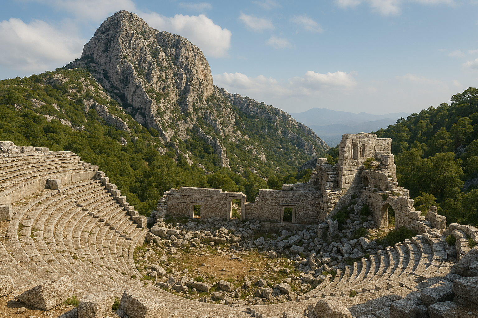
المسرح
المسرح منحوت جزئيًا في الصخر الأساس للمنحدر فوق المدينة.
الكافيا مهدّمة جزئيًا، إذ تساقطت صفوفها العليا على السفلى في انهيار بطيء سبّبته الزلازل الكبرى.
تبلغ سعته نحو 9,000 متفرّج.
هذا كبير على مدينة بحجم سكّان ساغالاسوس وبيان واضح للأهمية الإقليمية.
النطاق لا يُخطئه أحد.
المناظر عبر الوادي من الطبقة العليا من بين أوسع المناظر في طوروس.
يُحفظ مبنى المسرح (سكيناي فرونس) في حالة انهيار لا في شكل قائم.
كثير من كتله المزخرفة ملقاة على الأرض أمام الأوركسترا، بانتظار الدراسة.
الزوّار الذين يصعدون إلى أعلى الكافيا يرون المسرح كما أراد البناؤون القدماء أن يُرى.
البولوتيريون والأوديون
البولوتيريون — دار المجلس — يقع على الجانب الجنوبي من الأغورا العليا.
هو قاعة مستطيلة بمقاعد حجرية لمستشاري المدينة وإطار معماري دقيق.
قريبًا منه، الأوديون فضاء أداء أصغر مسقوف جزئيًا.
استُخدم الأوديون لإلقاء الموسيقى وتلاوة الشعر واجتماعات الجمعيات الطوعية والنقابات المهنية.
يوثّقان معًا الحياة المؤسّسية لمدينة بيسيدية ذاتية الحكم.
اجتمع البوليه (المجلس) في البولوتيريون.
تجمّع الديموس (الشعب) في الأغورا.
ملأت الحياة الثقافية للمدينة، في أنماطها الأهدأ، الأوديون.
معبد أبولو كلاريوس
كان الإله الراعي لساغالاسوس هو أبولو كلاريوس.
كان أبولو الوحياني في كلاروس بأيونيا، الذي انتشرت عبادته على نطاق واسع عبر آسيا الصغرى في الفترة الإمبراطورية.
معبده في ساغالاسوس، قائم جزئيًا، يحتلّ مدرّجًا على الحافة الغربية من المنطقة الضخمة.
تنجو عدّة صفوف من قاعدته وعدد صغير من الأعمدة القائمة.
تؤكّد النقوش الإهداء.
تشير الشظايا المعمارية إلى رفعة كورنثية دقيقة، بتفاصيل منحوتة بعناية على التيجان والإفريز.
قدّم أبولو كلاريوس الأوحياء عبر الماء — إله مناسب لمدينة كانت حياتها الاحتفالية تتخلّلها النوافير.
يربط المعبد ساغالاسوس بشبكة أوسع من عبادات أبولو عبر غرب آسيا الصغرى.
الهيرون
الهيرون معلَم جنائزي هلنستي.
يتّخذ شكل عمود طويل مربّع تعلوه نقوش منحوتة.
يتضمّن برنامجه النحتي محاربين مسلّحين وراقصين وعراة بطوليين.
قُورن الأسلوب بـأيقونوغرافيا الإسكندر في آسيا الصغرى أواخر القرن الرابع.
يشير هذا إلى أنّ المعلَم كرّم مواطنًا بارزًا في المدينة الهلنستية المبكّرة، ربّما محسنًا ذا روابط عسكرية بالبلاطات المقدونية أو الخلَفية.
الراقصون، المرتدون والمتحلّقون، يستحضرون الرثاء الطقسي.
المحاربون، الفخامة الاستعراضية.
المعلَم واحد من المنشآت الهلنستية القليلة في ساغالاسوس التي نجت إلى المدينة المرئية.
مجمّع الحمّامات الرومانية
يرتفع مجمّع حمّامات كبير على المنحدر الجنوبي.
كان في الأصل عدّة طوابق وواحدًا من أكبر المباني المفردة في ساغالاسوس.
يشمل التسلسل الروماني المعياري:
- الباليسترا — ساحة التمارين.
- الفريجيداريوم — غرفة باردة بحوض غطس.
- التيبيداريوم — غرفة دافئة.
- الكالداريوم — غرفة حارّة بحوض مسخَّن.
عوّضت تدفئة الهيبوكاوست المتقَنة تحت الأرضية عن الشتاء البارد.
انهارت الأقبية في الزلازل الكبرى.
لا تزال الجدران قائمة إلى ارتفاع كبير.
تظلّ آثار الكسوة الرخامية والجصّ المرسوم وفسيفساء الأرضيات مرئية في بعض الأماكن.
أعمدة الهيبوكاوست — أكوام قصيرة من الطوب تدعم الأرضية المرفوعة للغرف الحارّة — تنجو في عدّة غرف.
الحمّامات من أكثر المنشآت طموحًا معماريًا في الموقع.
الماكيلوم (سوق اللحوم)
الماكيلوم هو سوق اللحوم والطعام المسقوف في المدينة.
يفتح من الأغورا السفلى.
مخطّطه المستطيل، مع فناء مركزي ومتاجر محيطة، مثال نموذجي لنوع السوق المسقوف الروماني.
من النادر العثور على ماكيلوم بهذه السلامة في الأناضول الجبلية.
تنجو طاولات حجرية في بعض المتاجر.
تتحدّث قنوات الصرف في الفناء عن العمل اليومي للقصابة.
وجود ماكيلوم رسمي في مدينة نائية إلى هذا الحدّ هو في حدّ ذاته بيان عن الرومنة.
عبر مبانٍ كهذه انتقل القانون التجاري الروماني والعادات الحضرية إلى المقاطعات.
النافورة الدورية
نافورة رومانية مبكّرة صغيرة في الأغورا العليا.
تملك واجهة من أعمدة دورية قصيرة وعتب بسيط.
تسبق النيمفيومات الأكبر.
تقدّم مقابلًا هادئًا وعتيقًا للنافورة الأنطونية الأكثر بهرجة عبر الساحة.
ربّما وقفت النافورة الدورية في مركز مرحلة مبكّرة من المشهد المدني.
تنتمي إلى زمن كانت فيه الأغورا الهلنستية تُكيَّف تدريجيًا للأذواق الرومانية.
السيباستيون / معبد العبادة الإمبراطورية
حُدّد مجمّع معبد مكرَّس لـالعبادة الإمبراطورية على المدرّجات العليا.
كان هادريان والأباطرة الأنطونيون محور العبادة هنا.
هذا هو السياق المعماري للتماثيل الضخمة للسلالة الأنطونية التي استُعيدت رؤوسها من المدينة.
كان معرضًا سلاليًا واحدًا، تصوَّر كبرنامج نحتي وأيديولوجي متماسك.
تضرّر المبنى نفسه بشدّة في زلازل القرن السادس.
ينجو ما يكفي لإعادة بناء المخطّط الأساسي وموقع تماثيل العبادة.
كان المجمّع من أكثر مباني العبادة الإمبراطورية تجهيزًا فاخرًا في بيسيديا.
حيّ الفيلّا الرومانية
كشفت تنقيبات حديثة عن حيّ من البيوت الرومانية الكبيرة على المنحدر الشرقي.
هذه فيلّات بيريستيلية — بيوت بُنيت حول أفنية مركزية معمَّدة.
تملك الفيلّات فسيفساء وغرف استقبال مزخرفة بأناقة.
كانت تنتمي إلى العائلات النخبوية التي مولّت المعالم العامّة.
تشهد الفريسكوات والكسوة الرخامية والفخّار الدقيق في طبقات الدمار على مستوى عالٍ من المعيشة.
يتّبع تخطيط البيوت أعرافًا متوسطية عامّة، مكيَّفة مع التضاريس الجبلية الحادّة.
التنقيب في هذا الحيّ مستمرّ ويواصل إنتاج اكتشافات جديدة كلّ موسم.
أسوار المدينة والبوّابات
تحيط دائرة من أسوار المدينة بالجزء العلوي من الموقع.
بعض أجزاء الدائرة هلنستية؛ وأجزاء أخرى من العصور القديمة المتأخّرة.
عُزّزت الأسوار في القرنَين الخامس والسادس مع تدهور الأمن في المرتفعات.
تنجو أبراج البوّابات وأقسام من جدار الستار.
يمتدّ قسم مثير للإعجاب على طول الحافة العليا لمنطقة المسرح.
أعادت الإصلاحات الأنتيكية المتأخّرة استخدام الكتل الأقدم بحرّية.
يمكن رؤية ألواح مكتوبة من معالم تكريمية مبنية في الجدران — سجلّ مرئيّ لمدى دقّة إعادة تدوير المدينة المتأخّرة لماضيها الضخم.
إعادة بناء النيمفيوم الأنطوني
إذا كان لساغالاسوس صورة واحدة، فهي النيمفيوم الأنطوني.
الطريقة التي أُعيد بها تركيب هذه النافورة قصّة في حدّ ذاتها — تقنيًا وفلسفيًا.
الأناستيلوسيس كفلسفة
الأناستيلوسيس هو مبدأ الحفظ القائل بأنّ الأحجار الساقطة ينبغي إعادتها، حيثما أمكن، إلى مواضعها الأصلية.
تُستخدم الكتل الأصلية فقط للعناصر الإنشائية.
تُستخدم مواد جديدة قابلة للتمييز بوضوح للحشوات الضرورية تمامًا.
هو انضباط من ضبط النفس بقدر ما هو من إعادة الإعمار.
يتطلّب اليقين.
يجب تعريف كلّ كتلة.
يجب مطابقة كلّ مفصل.
يجب هندسة كلّ مسار حمل.
حيث يفشل اليقين، يتوقّف العمل.
حيث تكون هناك حاجة لمواد جديدة، يجب أن تكون مرئية كجديدة — باللون والنسيج والإنهاء السطحي.
يستطيع الزائر أن يقرأ بنظرة ما هو قديم وما هو حديث.
في ساغالاسوس، اعتمد الفريق البلجيكي الأناستيلوسيس قاعدةً موجِّهة لكلّ إعادات الإعمار الرئيسية.
النيمفيوم الأنطوني هو أكثر تعبير شامل عن تلك السياسة في تركيا.
حملة 1996–2010
انهار النيمفيوم الأنطوني في أوائل القرن السادس في خطّ طويل من الكتل الساقطة يمتدّ تقريبًا جنوب-جنوب-شرق.
حُفظ هذا التراصف تحت ركام لاحق.
كان، بشكل متناقض، أفضل حليف للمهندسين.
عنى ذلك أنّه يمكن قراءة الصفوف ككتاب ساقط — كتلة بكتلة، من الإفريز العلوي إلى الأساس.
ابتداء من عام 1996، بعد سنوات من التسجيل والرسم والتصوير والنمذجة ثلاثية الأبعاد، بدأ الفريق العملية البطيئة لرفع وإعادة تكديس الأحجار.
أُدخلت نوى من الفولاذ المقاوم للصدأ في الكتل المكسورة لمنحها سلامة إنشائية جديدة.
استُبدلت الشظايا المفقودة بأحجار جديدة مُعلَّمة بعناية، مقتلَعة من الحجر الجيري نفسه لساغالاسوس لكن تُركت أكثر خشونة قليلًا من الأسطح القديمة.
كانت بعض الكتل متضرّرة جدًا بحيث لا يمكن إعادتها إلى مواضع تحمل الحمل.
وُضعت هذه للعرض إلى جانب المبنى.
كشفت كتل أخرى، بمجرّد رفعها، عن نتوءات الرفع وعلامات البنّاء التي لم تُرَ منذ العصور القديمة.
اكتملت إعادة الإعمار عام 2010.
إعادة هندسة المياه
تُتبّع خطّ إمداد المياه الأصلي — قناة طويلة تعمل بالجاذبية من ينابيع فوق المدينة — وأُعيد بناؤه جزئيًا وأُعيد توصيله إلى الحوض العلوي.
يصل الماء الآن إلى ظهر النافورة.
يملأ الحوض العلوي.
ينسكب إلى الحوض الأدنى.
يجري باستمرار عبر الواجهة خلال موسم الزيارة.
التدفّق ليس مسرحًا.
هو ما صُمّم المبنى ليفعله.
الصوت، ورائحة الحجر البارد والطحالب الرطبة، وكيف يتحرّك الضوء على الرصيف المبلَّل — كانت جزءًا من التجربة القديمة.
هي جزء من التجربة الحديثة من جديد.
مفهوم "الموقع القديم الحيّ"
هذه هي العبارة التي يستخدمها فريق ساغالاسوس للنتيجة.
تلتقط طموحهم الأوسع.
ينبغي ألّا يكون الموقع مجموعة ثابتة من الأطلال المحفوظة.
ينبغي أن يكون مكانًا حيث، في أقسام مختارة بعناية، يمكن الشعور بحياة المدينة الأصلية من جديد.
النيمفيوم الأنطوني هو أوّل وأكمل تحقيق لذلك المثل.
ثمّة خطط لمشاريع أناستيلوسيس أخرى: شظايا من النيمفيوم الهادرياني (التيبيري)، وأجزاء من مجمّع العبادة الإمبراطورية، وأقسام من واجهة الحمّامات.
ستضيف هذه، في الوقت المناسب، إلى الإحساس بمدينة تعود ببطء إلى التركيز.
لماذا تهمّ خارج ساغالاسوس
مشاريع الأناستيلوسيس الكبرى من هذا النوع نادرة في تركيا.
يفوق نطاق السجلّ الأثري الموارد المتاحة للحفظ.
أصبح النيمفيوم الأنطوني مرجعًا في الممارسة الدولية للحفظ.
هو مثال على كيف يستطيع المنهج الصبور والتمويل طويل الأمد والخبرة متعدّدة التخصّصات إعادة بناء ليس واجهة فقط بل الحضور المادي والحسّي الكامل لمعلَم قديم.
للحُفّاظ المدرَّبين على مواقع البحر المتوسط، زيارة النيمفيوم الأنطوني نوع من الحجّ.
للمسافرين، هي ببساطة واحدة من أكثر الأشياء إرضاءً للنظر إليها في تركيا.
ماركوس أوريليوس الضخم
في صيف 2008، كشف المنقّبون العاملون داخل مجمّع العبادة الإمبراطورية عن رأس رخامي، أكبر من إنسان.
كان ملقًى وجهه إلى الأعلى بين ركام منهار.
كان رأس ماركوس أوريليوس.
كان اكتشافه واحدًا من أكثر اكتشافات علم آثار الأناضول إثارة للاهتمام الإعلامي في الجيل الماضي.
النطاق
شظايا استُعيدت مع الرأس — جزء من قدم، يد بأصابع منحوتة بأناقة — تسمح بإعادة بناء التمثال الأصلي بارتفاع نحو خمسة أمتار.
كان هذا صورة ضخمة واحدة.
صُمِّمت للوقوف في تجويف أو على قاعدة عالية داخل مبنى العبادة.
قُصِد أن تكون مرئية عبر الغرفة من زوايا كثيرة.
الرأس وحده يزيد ارتفاعه عن 70 سنتيمتر.
يزن عدّة مئات من الكيلوغرامات.
القدم، المعروضة بجانب الرأس في متحف بوردور، بحجم طفل صغير.
اليد، بأصابعها الطويلة الملتفّة بلطف، على المقياس نفسه.
الصنعة
الرأس منحوت في رخام أبيض دقيق.
تجاعيد اللحية والشعر محفورة بعمق.
الجبين متغضّن قليلًا.
النظرة مائلة إلى الداخل وبعيدة.
هذا هو النوع الفلسفي الذي خصّصه النحّاتون الأنطونيون لماركوس أوريليوس — وجه التأمّلات.
العينان مشطوبتان بشكل خفيّ.
الشفتان منفرجتان بما يكفي للإيحاء بالكلام أو الفكر الهادئ.
الشفّة السفلى ممتلئة بما يكفي لإعطاء الوجه نوعًا من الذكاء الكئيب.
التنفيذ ليس إقليميًا.
إمّا الرخام أو النحّات (وعلى الأرجح كلاهما) جاء من مركز إمبراطوري كبير.
آسيا الصغرى أو اليونان أو روما نفسها هي المصادر الأرجح.
السياق
عُثر على الرأس بين الجدران المنهارة لمعبد العبادة الإمبراطورية.
كان قائمًا هناك مع تماثيل ضخمة أخرى للسلالة الأنطونية.
أسقطت زلازل القرن السادس المبنى.
سقط الرأس وجهه إلى الأعلى ونجا سليمًا في الأساس.
كثير من التماثيل الأخرى تكسّر إلى قطع صغيرة جدًا أو متضرّرة جدًا بحيث لا يمكن تعريفها بأمان.
موقع الرأس بين الركام، واتّجاه الكتل القريبة، يعطيان بعض القرائن عن الترتيب الأصلي لتماثيل العبادة.
العرض
الرأس الآن القطعة المركزية في معرض ساغالاسوس بـمتحف بوردور.
تُعرض القدم واليد بجانبه في علاقتهما النسبية المعاد بناؤها.
صورة فوتوغرافية لزائر بجانب الرأس تنقل المقياس أفضل من أيّ قياس.
العرض من أقوى عروض القطعة الواحدة في أيّ متحف تركي.
يعمل تقريبًا كمعرض صور بحدّ ذاته.
لكثير من الزوّار، هذا أكثر شيء لا يُنسى يرونه في بوردور — وأحد أكثر الأشياء التي لا تُنسى في المنطقة كلّها.
الأثر العامّ
أصبح اكتشاف ماركوس أوريليوس خبرًا دوليًا عام 2008.
جلب موجة جديدة من الاهتمام إلى ساغالاسوس.
نشرت صحف في بلجيكا والمملكة المتّحدة وتركيا والولايات المتّحدة تغطية على الصفحة الأولى.
نشرت كلّ من نيويورك تايمز والغارديان تحقيقات رئيسية.
أكّد الاكتشاف لجمهور عالمي ما عرفه المتخصّصون بالفعل.
كانت العبادة الإمبراطورية في ساغالاسوس من أكثرها تجهيزًا فاخرًا في آسيا الصغرى.
جلب الاكتشاف أيضًا موارد جديدة للمشروع وسرّع العمل على مجمّع العبادة الإمبراطورية.
المعبد الإمبراطوري الروماني في ساغالاسوس
لم يكن رأس ماركوس أوريليوس وحده.
عبر مواسم متعاقبة، أنتج المجمّع نفسه والمنشآت المجاورة رؤوسًا — وفي بعض الحالات شظايا أخرى — لمجموعة إمبراطورية أنطونية وهادريانية كاملة.
تشكّل هذه الصور مجتمعةً معبدًا إمبراطوريًا متماسكًا.
هي عائلة منحوتة من الأباطرة والإمبراطورات أُقيمت في المدينة العليا ورُعيت كمحور للعبادة.
الرؤوس الإمبراطورية
-
هادريان (حكم 117–138 م). مؤسّس التشكيل السلالي الذي سيشكّل القرن الثاني. كان رأس ساغالاسوس من بين أوائل الاكتشافات البلجيكية. لا يزال من أدقّ صور القرن الثاني للإمبراطور المعروفة في أيّ مكان من العالم الروماني. السمات مثاليّة لكنّها محدّدة: اللحية الشهيرة، التجاعيد المنمذجة بعناية، ونظرة هادئة مائلة قليلًا إلى الداخل.
-
أنطونينوس بيوس (حكم 138–161 م). وريث هادريان بالتبنّي وأحد أكثر الأباطرة سلامًا في الفترة. صورة ساغالاسوس مثاليّة وهادئة ومتعبة قليلًا. اللحية الطويلة والشعر الكثيف نموذجيان للنوع الأنطوني الناضج للصورة.
-
فاوستينا الكبرى (توفّيت 140 م). زوجة أنطونينوس بيوس، أُلِّهت بعد وفاتها. وجود صورة ضخمة لفاوستينا في مجمّع ساغالاسوس لافت. يشير إلى أنّ الإمبراطورة كُرّمت بحقّها، بتمثالها الخاصّ، في الإطار المعماري نفسه مع زوجها وخلفائه.
-
ماركوس أوريليوس (حكم 161–180 م). الرأس الضخم الموصوف في القسم السابق. تسمح شظايا القدم واليد بإعادة بناء آمنة بشكل معقول للتمثال الكامل بارتفاع نحو خمسة أمتار.
لماذا المجموعة استثنائية
قليلة هي المدن الإقليمية الأخرى في الشرق الروماني التي أنتجت مجموعة سلالية بهذا التماسك من سياق واحد.
أقرب نظائر هي في مواقع مثل أنطاكية البيسيدية وأفروديسياس وبرغي.
تعطي هذه أدلّة قابلة للمقارنة في شكل مجزَّأ.
مجموعة ساغالاسوس مكتملة على نحو غير اعتيادي.
كما أنّها موثَّقة على نحو غير اعتيادي في سياقها الأثري، بفضل التنقيب البلجيكي الدقيق.
التأريخ والتعريفات الأيقونوغرافية والعلاقة بين التماثيل وإطارها المعماري كلّها آمنة.
ما يعنيه المعبد
المجموعة دليل مباشر على ولاء ساغالاسوس الدقيق والمتّسق لروما.
تُظهر أيضًا استعداد النخبة المحلية لدفع ثمن الرخام — وعلى الأرجح استيراد النحّاتين — الذي أثبت ذلك.
لم تكن العبادة الإمبراطورية لاهوتية بالمعنى الحديث.
كانت نظامًا للتكريم العامّ ربط المقاطعات بالمركز.
نطاق وجودة إسهام ساغالاسوس في هذا النظام تضع المدينة في الصفّ الأوّل للولاء البيسيدي (وفي الواقع الآسيوي).
تجاوز النطاق الضخم — تماثيل بارتفاع أربعة إلى خمسة أمتار — التكريم التقليدي بكثير.
اختارت ساغالاسوس تضخيم الصور الإمبراطورية حرفيًا كما احتفاليًا.
الأهمية الفنية-التاريخية
إلى جانب معناها السياسي، صور ساغالاسوس هي ببساطة من بين أدقّ رؤوس القرن الثاني الإمبراطورية التي نجت من أيّ مكان.
ظهرت في معارض إعارة كبرى في أوروبا.
تواصل الاستشهاد بها كنماذج مقارَنة في دراسات الصور الرومانية.
معرض متحف بوردور هو، في الواقع، دراسة صغيرة في الرخام عن السلالة الأنطونية.
لأيّ مهتمّ بالصور الإمبراطورية الرومانية، المعرض مشاهدة أساسية.
جامعة لوفان والمشروع متعدّد التخصّصات
مشروع البحث الأثري لساغالاسوس (SARP) يقع مقرّه في جامعة لوفان الكاثوليكية (KU Leuven) في بلجيكا.
يعمل على الموقع منذ 1990.
هو واحد من أطول البعثات الأجنبية عملًا وأكثرها طموحًا منهجيًا وأشدّها نشرًا في تركيا.
أصبح نموذجًا دوليًا لكيفية إجراء بحث أثري واسع النطاق طويل الأمد.
المدراء
مارك فالكنز (1990–2013) كان المدير المؤسّس.
كان أستاذًا لعلم الآثار الكلاسيكي في جامعة لوفان.
كان قد عمل سابقًا في ساغالاسوس كجزء من مسح ستيفن ميتشل عام 1986.
جمعت رؤيته للموقع بين المنهج الكلاسيكي والتزام واسع على نحو غير اعتيادي بالتعاون العلمي.
في عهد فالكنز، طوّر المشروع النموذج متعدّد التخصّصات الذي لا يزال يعرّفه.
أشرف على إعادات الإعمار المبكّرة، بما فيها مشروع النيمفيوم الأنطوني الطويل.
درّب جيلَين من علماء الآثار، يقود كثير منهم اليوم مشاريعهم الخاصّة عبر المتوسط.
تقاعد كمدير عام 2013 لكنّه لا يزال مشاركًا في النشر.
يَرون بوبلوم (2013–حتى الآن) واصل المشروع ووسّعه.
هو عضو سابق في فريق فالكنز.
تخصّصه الخاصّ الثقافة المادية الرومانية، خاصّة الفخّار والتاريخ الاقتصادي.
في عهد بوبلوم، وضع المشروع تأكيدًا متزايدًا على آثار المشهد الطبيعي والاستدامة وبناء القدرات مع الزملاء الأتراك والعرض العامّ للموقع.
نموذج متعدّد التخصّصات
منذ مواسمه الأولى، أدمج مشروع ساغالاسوس علم الآثار الكلاسيكي مع العلوم الأخرى.
كان هذا نادرًا في حينه.
لا يزال نموذجيًا حتى اليوم.
يشمل الفريق الحالي:
-
جيولوجيين. يرسمون خرائط الصدوع النشطة. يعيدون بناء التاريخ الزلزالي للحوض. يعرّفون المحاجر القديمة. يحلّلون أنماط التجوية على الرخام.
-
علماء المناخ القديم. يستخدمون نوى الرواسب من بحيرة بوردور والأحواض القريبة. يدرسون سجلّات حبوب اللقاح والتحليلات النظائرية. يعيدون بناء المناخ على مدى عدّة آلاف من السنين الماضية.
-
علماء النبات والحيوان الأثريين. يعرّفون النباتات المزروعة والحيوانات الداجنة من سياقات التنقيب. يعيدون بناء الاقتصاد الزراعي والنظام الغذائي للمدينة.
-
متخصّصين في الحمض النووي القديم. درسوا بقايا بشرية من المدينة. يساهمون في البحث العالمي عن Yersinia pestis وديناميكيات الأمراض الجائحية. المادة الهيكلية من أفق طاعون يوستينيانوس كانت مهمة بشكل خاصّ.
-
فرق النمذجة ثلاثية الأبعاد والتراث الرقمي. يحتفظون بسجلّ فوتوغرامتري كامل لكلّ معلَم قائم. يوثّقون كثيرًا من الكتل السائبة أيضًا. الأرشيف الرقمي لساغالاسوس من بين الأكثر شمولًا لأيّ موقع أثري.
-
علماء الحفظ. يطوّرون بروتوكولات للرخام والحجر الجيري والجصّ المرسوم مناسبة للبيئة العالية الارتفاع. يراقبون الأداء طويل الأمد لمشاريع الأناستيلوسيس.
-
متخصّصي الثقافة المادية. يدرسون الفخّار الأحمر المصقول الشهير لساغالاسوس — فخّار طاولة عالي الجودة صُدِّر عبر شرق المتوسط. يدرسون الورش التي أنتجته والأفران وشبكات التوزيع الإقليمية.
مشروع "أرض ساغالاسوس"
إلى جانب التنقيب الحضري، يدير الفريق مسحًا إقليميًا للمشهد الطبيعي يُعرف بـأرض ساغالاسوس.
يغطّي المسح المنطقة الأوسع التي سيطرت عليها المدينة ذات يوم.
يدمج عدّة طرق:
- المشي الأثري الحقلي (الجمع السطحي المنهجي للفخّار والاكتشافات الأخرى).
- رسم الخرائط الجيومورفولوجية.
- الاستشعار عن بُعد — بما في ذلك صور الأقمار الاصطناعية والتصوير الجوّي.
- التسجيل الإثنوغرافي للقرى الحديثة.
الهدف هو إعادة بناء تاريخ الاستيطان من ما قبل التاريخ إلى الحاضر.
مسح أرض ساغالاسوس من أكثر المشاريع الإقليمية طموحًا من نوعه في جنوب تركيا.
أثبت أنّ ساغالاسوس لا يمكن فهمها بمعزل.
كانت المدينة قمّة شبكة كثيفة متكاملة من القرى والمزارع.
شكّلت معًا الواقع الإقليمي للمرتفعات البيسيدية.
النشر والوصول
ينشر فريق ساغالاسوس بكثافة.
تُنشَر سلسلة ساغالاسوس الرسمية من قبل مطبعة جامعة لوفان.
تمتدّ إلى مجلّدات كثيرة، كلّ منها مكرَّس لمعلَم أو قطاع أو موضوع معيّن.
تظهر مقالات فردية في المجلّات الرئيسية: الدراسات الأناضولية، مجلّة علم الآثار الروماني، المجلّة الأمريكية لعلم الآثار، مجلّة العلوم الأثرية.
الوصول الشعبي أولوية أيضًا.
موقع المشروع والمعارض والأفلام الوثائقية ووسائل التواصل الاجتماعي جعلت ساغالاسوس واحدة من أشهر التنقيبات في العالم.
الجمع بين الصرامة الأكاديمية والتواصل العامّ جزء ممّا يجعل المشروع نموذجًا للحقل.
العمل الأثري
لانكورونسكي، 1884–1885
أوّل أوروبي قام بتسجيل علمي جدّي لساغالاسوس كان الكونت البولندي-النمساوي كارول لانكورونسكي.
صوّرت بعثته الأطلال ومسحتها كجزء من مشروع أوسع عن مدن بامفيليا وبيسيديا في منتصف ثمانينيات القرن التاسع عشر.
مجلّداته المنشورة الفاخرة، مدن بامفيليا وبيسيديا (1890–1892)، لا تزال سجلًّا قيّمًا.
توثّق معالم لم تنهَر بعد أكثر.
رسومات لأعمدة النيمفيوم الأنطوني وهي لا تزال قائمة.
مخطّطات للأغورا العليا قبل الاضطراب الحديث.
رفعات للمسرح بعدد أقلّ من الكتل الساقطة ممّا هو عليه اليوم.
أرسى توثيق لانكورونسكي المفردات البصرية الأساسية للموقع التي سيرثها العلماء اللاحقون.
الرحّالة الأقدم
قبل لانكورونسكي، مرّ عدد من الرحّالة الأوروبيين وتركوا ملاحظات قصيرة.
يُنسب تقليديًا إلى بول لوكا عام 1706 أوّل سجلّ غربي حديث للأطلال.
قدّم فرانسيس أرونديل عام 1824 وصفًا أكثر تفصيلًا.
كانت هذه الروايات المبكّرة مقتضبة لكنّها ثبّتت ساغالاسوس على خريطة الوعي الأنتيكي الأوروبي.
وضعت الموقع ضمن إعادة الاكتشاف الأوسع لآسيا الصغرى في القرن التاسع عشر.
ستيفن ميتشل، 1986
بعد قرن من لانكورونسكي، عام 1986، قاد المؤرّخ البريطاني ستيفن ميتشل مسحًا في ساغالاسوس.
كان آنذاك في جامعة سوانزي.
أعاد المسح إرساء أهمية الموقع ووضع الأجندة لما سيأتي.
عمل ميتشل الأوسع على بيسيديا تأسيسي.
قدّم التركيب المنشور بعنوان الأناضول: الأرض والرجال والآلهة في آسيا الصغرى (1993) الإطار الإقليمي والتاريخي الذي ستوضع فيه ساغالاسوس.
عرّف مسح 1986 المعالم الرئيسية.
رسم خريطة البقايا القائمة المرئية.
قدّم الحجّة للتنقيب المنهجي.
مارك فالكنز، 1990–2013
بدأ التنقيب البلجيكي عام 1990 في عهد فالكنز، الذي كان مشاركًا في عمل ميتشل عام 1986.
ركّز العقد الأوّل على الأغورا العليا والنيمفيومين والمسرح.
ركّز العقد الثاني على الأغورا السفلى والحمّامات ومجمّع العبادة الإمبراطورية.
ركّز العقد الثالث على المسح الإقليمي وعلى النشر الكامل للسجلّ المتراكم.
اكتُشف رأس هادريان الضخم في منتصف التسعينيات.
اكتُشف رأس ماركوس أوريليوس عام 2008.
كانت إعادة بناء النيمفيوم الأنطوني، الممتدّة من 1996 إلى 2010، الإنجاز الرئيسي في الحفظ لسنوات فالكنز.
عبر هذه العقود، درّبت الحملات السنوية للمشروع عشرات الطلّاب البلجيكيين والدوليين.
كثيرون منهم تابعوا قيادة مشاريعهم الخاصّة.
يَرون بوبلوم، 2013–حتى الآن
في عهد بوبلوم، وسّع المشروع مكوّناته البيئية والرقمية.
فُتحت مناطق تنقيب جديدة في الأحياء الشرقية وورش الفخّار.
يستمرّ البرنامج الطويل للحفظ والعرض.
تكثّف المسح الإقليمي لأرض ساغالاسوس.
تستمرّ الحملات الصيفية السنوية.
يظلّ برنامج النشر نشطًا، مع مجلّدات ومقالات جديدة تظهر كلّ عام.
شهد إدارة بوبلوم أيضًا تفاعلًا متزايدًا مع المؤسّسات والسلطات التركية.
أصبحت العلاقة مع متحف بوردور وثيقة بشكل خاصّ.
متحف بوردور
تُحفظ مجموعة المتحف الرئيسية من ساغالاسوس في متحف بوردور الأثري في عاصمة المحافظة، على بعد 30 كم.
معرض ساغالاسوس هناك من أرقى عروض المتاحف الصغيرة في تركيا.
يحتوي على:
- الرؤوس الأنطونية الضخمة لهادريان وأنطونينوس بيوس وفاوستينا الكبرى وماركوس أوريليوس.
- القدم واليد الضخمتان لتمثال ماركوس أوريليوس.
- فخّار دقيق، بما في ذلك قطع تمثيلية من الفخّار الأحمر المصقول لساغالاسوس.
- نقوش، تكريمية وجنائزية على حدّ سواء.
- نحت معماري: تيجان، شظايا من الأفاريز والكورنيشات.
- اكتشافات صغيرة مختارة: نقود، زجاج، تماثيل طينية.
كانت علاقة المتحف بالتنقيب وثيقة ومستمرّة.
تتحرّك الاكتشافات بكفاءة من الحقل إلى مختبر الحفظ إلى صندوق العرض.
يُحدَّث المعرض كلّما تأتي مادة جديدة.
القدرة المحلية
موضوع متّسق لمشروع ساغالاسوس، خاصّة في عهد بوبلوم، كان التعاون مع الجامعات التركية.
تدريب علماء الآثار الأتراك أولوية.
كثير من أعضاء الفريق البارزين اليوم خرّيجو أو شركاء مؤسّسات تركية.
أصبحت ساغالاسوس نقطة محورية للتدريب في علم آثار المشهد الطبيعي وعلم النبات الأثري وعلم القياس الأثري في تركيا.
يوضّح المشروع كيف يمكن لبعثة أجنبية طويلة الأمد أن تخدم كمنصّة للتطوير الأكاديمي المحلي.
الأرقام والقياسات
| البند | القيمة |
|---|---|
| الارتفاع (نطاق الموقع) | 1,450 – 1,700 م |
| المسافة من أغلاسون | 7 كم (صعودًا، طريق جبلية) |
| المسافة من بوردور | 30 كم |
| المسافة من أنطاليا | 110 كم |
| المسافة من إسبارطة | 45 كم |
| السكّان التقديرية في الذروة (النواة الحضرية) | 5,000 – 10,000 |
| سعة المسرح | نحو 9,000 متفرّج |
| ارتفاع النيمفيوم الأنطوني | نحو 9 م، طابقان |
| عرض النيمفيوم الأنطوني | نحو 28 م |
| فترة إعادة بناء النيمفيوم الأنطوني | 1996 – 2010 |
| ارتفاع تمثال ماركوس أوريليوس الضخم | نحو 5 م |
| ارتفاع رأس ماركوس أوريليوس الضخم | نحو 70 سم |
| تاريخ النيمفيوم الهادرياني المعاد | تيبيري (أوائل القرن الأوّل الميلادي) |
| بدء التنقيب | 1990 (جامعة لوفان، فالكنز) |
| المدير الحالي للتنقيب | يَرون بوبلوم (منذ 2013) |
| المدير السابق للتنقيب | مارك فالكنز (1990–2013) |
| المسح الأقدم | 1986 (ستيفن ميتشل، سوانزي) |
| أوّل توثيق أوروبي | 1706 (بول لوكا) |
| أوّل منشور علمي | 1890–1892 (لانكورونسكي) |
| الزلازل الكبرى | نحو 518 م و541–543 م |
| طاعون يوستينيانوس | 541–543 م فصاعدًا |
| الهجر النهائي | أواخر القرن السابع الميلادي |
| درجة الحرارة الصيفية النهارية | نحو 25–30 درجة مئوية |
| الشتاء | ثلجي، الموقع مغلق إلى حدّ كبير |
| مدّة الزيارة الموصى بها | 2.5 – 3 ساعات (الحدّ الأدنى) |
| عاصمة المحافظة | بوردور |
| القضاء | أغلاسون، محافظة بوردور |
| الدولة | تركيا |
معلومات الزائر
الوصول إلى الموقع
تقع ساغالاسوس على بعد نحو 7 كم صعودًا من بلدة أغلاسون.
أغلاسون على بعد نحو 30 كم من بوردور.
هي على بعد نحو 110 كم من أنطاليا.
من أنطاليا، أكثر الطرق شيوعًا عبر D650 شمالًا نحو بوردور.
تنعطف نحو أغلاسون على الجانب الغربي من بحيرة بوردور.
ثمّ تصعد طريقًا جبلية ضيّقة جيّدة الرصف إلى موقف سيّارات الموقع.
الكيلومترات السبعة الأخيرة شديدة الانحدار ومتعرّجة وجميلة.
في الشتاء، تُغلَق الطريق أحيانًا بسبب الثلج.
حتى في أواخر الخريف أو أوائل الربيع، من الحكمة التحقّق من الأحوال.
لا يوجد نقل عامّ منتظم إلى الموقع نفسه.
تعمل حافلات الدولموش الصغيرة من بوردور إلى أغلاسون.
من أغلاسون، يُؤخذ الطريق الأخير بسيّارة أجرة أو بسيّارة خاصّة.
من إسبارطة، المسافة نحو 45 كم، أيضًا عبر طرق جبلية.
من مطار أنطاليا الدولي، الرحلة نحو ساعتَين، حسب حركة المرور في أنطاليا نفسها.
الساعات والتذاكر
الموقع مفتوح يوميًا خلال موسم الزيارة.
الساعات عادة من الصباح الباكر حتى أواخر بعد الظهر.
أوقات الافتتاح والإغلاق المحدّدة تتغيّر مع الموسم.
في الصيف، تمتدّ ساعات الافتتاح إلى أوائل المساء.
تُقبَل بطاقة المتاحف التركية (Müzekart Türkiye) عند المدخل.
تُقبَل أيضًا بطاقة متاحف البحر المتوسط، التي تشمل المنطقة الجنوبية من البلاد.
كلاهما يستحقّ الاستخدام إذا كنت تجمع بين ساغالاسوس ومتحف بوردور وأسبندوس وبرغي والمواقع الأخرى في المنطقة.
تُباع تذاكر الدخول الفردية أيضًا عند البوّابة.
الوقت في الموقع
خطّط لـ2.5 إلى 3 ساعات على الأقلّ.
المدرّجات شديدة الانحدار والموقع واسع.
التسرّع سيكون خطأً.
إذا كنت تتمتّع بالقدرة والوقت، نصف يوم أفضل.
الزوّار ذوو الاهتمام القوي بالعمارة أو النحت أو أعمال الحفظ يمكن أن يقضوا بسهولة يومًا كاملًا هنا.
النيمفيوم الأنطوني وحده يستحقّ ساعة غير متعجّلة.
المسرح، بصعوده الطويل إلى الصفوف العليا، التزام كبير آخر من الوقت والجهد.
الموسم
الموسم المثالي يمتدّ من أواخر مايو إلى أوائل أكتوبر.
ذروات النهار حوالي 25–30 درجة مئوية.
الأمسيات باردة، أحيانًا قارسة.
يوليو وأغسطس أحرّ الشهور.
يحفظ الارتفاع العالي الحرارة من أن تصبح خانقة.
يجلب الربيع زهور البرّية عبر المدرّجات — شقائق النعمان، السوسن، الأسفوديل.
هو أحد أجمل أوقات الزيارة.
يجلب الخريف ضوءًا صافيًا ذهبيًا وأصباحًا أبرد بشكل متزايد.
يجلب الشتاء ثلجًا كثيفًا.
غالبًا ما تكون الطريق غير سالكة في الشتاء.
يكون الموقع مغلقًا عمومًا في أبرد الأشهر.
حتى في الأيّام الصافية، المدرّجات العليا غير آمنة في الشتاء.
ما يجب إحضاره
-
طبقات للرياح. حتى في يوليو يمكن أن تكون المدرّجات العليا باردة. الفجوة الحرارية بين الشمس والظلّ كبيرة.
-
الكثير من الماء. ثمّة ظلّ قليل. المرطّبات المتوفّرة في الموقع محدودة.
-
أحذية متينة. الرصف غير مستوٍ. الصعود حقيقي. كثير من الأسطح حجر جيري غير معالج.
-
حماية من الشمس. يجعل الارتفاع الأشعّة فوق البنفسجية أقوى ممّا تشعر به. الهواء جافّ، ممّا يعني أنّ من السهل التقليل من تقدير حروق الشمس.
-
قبّعة. الأكمام الطويلة الخفيفة مفيدة أيضًا للشمس والرياح.
-
كاميرا بتقريب معتدل. كثير من أكثر المواد إثارة على مسافة متوسّطة. أعمدة النيمفيوم، كافيا المسرح، المنحدرات المقابلة — كلّها تستفيد من عدسة أطول.
-
نقود. مبلغ صغير مفيد لأيّ مرطّبات صغيرة عند مدخل الموقع.
-
دليل سياحي أو مخطّط مطبوع. الموقع كبير والعنونة انتقائية.
القريب
-
متحف بوردور (30 كم). أساسي. الرؤوس الإمبراطورية الضخمة لهادريان وأنطونينوس بيوس وفاوستينا الكبرى وماركوس أوريليوس هنا. معظم المواد المنقولة من الموقع معروضة. خطّط لساعتَين للمتحف. ادمجه مع ساغالاسوس في اليوم نفسه إذا كان لديك الطاقة.
-
بحيرة سالدا (نحو 100 كم غرب بوردور). البحيرة الفيروزية الألبية الشهيرة، التي تُقارن غالبًا ببحيرة تاهو وجزر المالديف بنفس القدر. وجهة طبيعية لافتة بحدّ ذاتها.
-
بحيرة بوردور. بحيرة مالحة جنوب مدينة بوردور مباشرة. مهمّة للطيور المهاجرة. مرئية من مدرّجات ساغالاسوس في الأيّام الصافية.
-
أنطاكية البيسيدية / يالفاج (نحو 130 كم شمالًا). بعيدة لكنّها تاريخيًا المكمّل الطبيعي لساغالاسوس في أيّ جولة في بيسيديا. مقرّ المستعمرة الرومانية التي بشّر منها بولس.
-
كريمنا، أدادا، ترميسوس. لمن يريدون مسارًا إقليميًا أعمق عبر بيسيديا. لكلّ منها طابعها الخاصّ وإطارها الدراماتيكي الخاصّ.
-
أنطاليا (110 كم). المدينة الساحلية الكبرى. القاعدة الأكثر شيوعًا للزوّار الدوليين.
إمكانية الوصول
ساغالاسوس موقع صعب للزوّار ذوي الحركة المحدودة.
التضاريس شديدة الانحدار.
الرصف غير مستوٍ.
الارتفاع نفسه متعب.
لا توجد مصاعد ولا منحدرات ولا ممرّات ممهّدة في المنطقة الضخمة.
الصعود بين المدرّجات كبير.
يستطيع الزوّار ذوو صعوبات الحركة الوصول مع ذلك إلى منصّات المشاهدة الأدنى قرب موقف السيّارات.
يمكن رؤية النيمفيوم الأنطوني من مسافة محترمة من نقاط المشاهدة هذه.
يتطلّب المسرح والمدرّجات العليا صعودًا مستدامًا قد لا يكون ممكنًا للجميع.
حتى المشاة اللائقون ينبغي أن يقيّسوا أنفسهم وأن يشربوا الماء بشكل متكرّر.
أيّ شخص يعاني من حالات قلبية وعائية أو تنفّسية ينبغي أن يكون على دراية بالارتفاع.
العمليات
ثمّة مكتب موقع صغير ومرطّبات محدودة قرب المدخل.
مرافق المراحيض أساسية.
لا توجد متاجر؛ إذا كنت تريد دليلًا، اشتره مسبقًا في أنطاليا أو بوردور أو عبر الإنترنت.
يمكن ترتيب المرشدين عبر مكتب الموقع أو عبر فنادق في أغلاسون وبوردور.
يضيف مرشد عليم الكثير في ساغالاسوس.
هذا صحيح بشكل خاصّ أمام النيمفيوم الأنطوني، حيث قصّة إعادة الإعمار في حدّ ذاتها جزء رئيسي ممّا يجعل الزيارة لا تُنسى.
الأسئلة الشائعة
هل تستحقّ ساغالاسوس الانعطاف من أنطاليا؟
نعم بشكل قاطع.
هي من بين أكثر المواقع القديمة في تركيا إثراءً.
هي واحدة من القلّة جدًا التي أُعيد فيها بناء معلَم رئيسي بشكل كامل وأصيل.
الإطار والنطاق وجودة عمل الحفظ تجعل منها معًا تجربة فريدة.
لماذا تُسمّى "أثينا بيسيديا"؟
العبارة توسيع لاحق لوصف سترابون لساغالاسوس بـ"المدينة الأولى في بيسيديا".
تلتقط دور المدينة كعاصمة سياسية وثقافية للمرتفعات البيسيدية.
كانت المكان الذي اجتمعت فيه النخبة الإقليمية، وحيث أُدّيت العبادة الإمبراطورية في أكثر صورها فخامة، وحيث طُلبت أرقى عمارة ونحت في المنطقة.
هل أخذها الإسكندر فعلًا دون حصار؟
وفقًا للقراءة المعيارية لكتاب أريانوس الأنابسيس، اختار مواطنو ساغالاسوس الاستسلام عندما وصل الإسكندر عام 333 ق.م.
هذا على عكس ترميسوس القريبة، التي لم يكلّف الإسكندر نفسه عناء حصارها بسبب دفاعاتها الهائلة.
أعفى الاستسلام السلمي ساغالاسوس من الدمار المادي.
أدمج المدينة من البداية في العالم الهلنستي.
ما الذي يجعل النيمفيوم الأنطوني خاصًّا؟
شيئان.
جودة العمارة الأصلية — نافورة زخرفية من طابقَين من عصر ماركوس أوريليوس بأعمدة كورنثية وتجاويف مملوءة بالتماثيل.
صرامة إعادة الإعمار الحديثة بالأناستيلوسيس.
هو النيمفيوم الروماني الوحيد ذو الطابقَين في تركيا الذي خضع للأناستيلوسيس وأُعيدت إليه المياه العاملة.
لمن كان التمثال الضخم؟
ماركوس أوريليوس، الإمبراطور الفيلسوف (حكم 161–180 م).
عُثر على الرأس عام 2008 في مجمّع العبادة الإمبراطورية.
كان التمثال الأصلي بارتفاع نحو خمسة أمتار.
الرأس والقدم واليد معروضة معًا الآن في متحف بوردور.
أين الرؤوس الإمبراطورية الآن؟
في متحف بوردور الأثري، على بعد 30 كم من الموقع في عاصمة المحافظة.
المتحف أساسي لأيّ زيارة جدّية.
الرؤوس الأنطونية الضخمة هي القطعة المركزية لمعرض ساغالاسوس.
لماذا هُجرت المدينة؟
مزيج من العوامل.
زلزالان كبيران (نحو 518 م و541–543 م).
طاعون يوستينيانوس (من 541–543 م فصاعدًا).
تراجع طويل بطيء للتجارة بعيدة المدى وللحماية الإمبراطورية في المرتفعات الأناضولية.
بحلول أواخر القرن السابع، كان الموقع فارغًا فعليًا.
هل ثمّة ماء جارٍ في الموقع؟
نعم.
أُعيد توصيل النيمفيوم الأنطوني بإمداد المياه الأصلي.
الشلّال حقيقي، لا مدبَّر.
هو أحد أكثر تفاصيل أيّ زيارة لا تُنسى.
هي أقرب تجربة في تركيا للوقوف داخل معلَم روماني عامل.
هل يمكنني الزيارة في الشتاء؟
عادة لا.
يُغلق الثلج بانتظام الطريق الجبلية.
الموقع مغلق رسميًا في أبرد الشهور.
تبقى الطريق إلى أغلاسون مفتوحة معظم العام.
الكيلومترات السبعة الأخيرة إلى الموقع قد تكون غير سالكة من أواخر نوفمبر إلى أوائل أبريل.
أواخر الربيع إلى أوائل الخريف هي نافذة الزيارة العملية.
كم من الوقت ينبغي أن أخطّط للموقع؟
حدّ أدنى 2.5 إلى 3 ساعات من المشي.
نصف يوم إذا كنت تريد إنصاف المدرّجات والمسرح.
أضف ساعتَين أخريَين لمتحف بوردور.
يوم أثري كامل (ساغالاسوس في الصباح، متحف بوردور بعد الظهر) هو التوصية المعيارية.
هل لا يزال الفريق البلجيكي يعمل هنا؟
نعم.
جامعة لوفان، الآن في عهد يَرون بوبلوم، تنقّب وتحفظ وتمسح باستمرار منذ 1990.
ثمّة حملات صيفية كلّ عام.
المشروع من أطول البعثات الأثرية الأجنبية عملًا في تركيا.
ماذا ينبغي أن أقرأ قبل الزيارة؟
موقع المشروع الرسمي (sagalassos.be) هو أفضل نقطة بداية.
إلى جانب ذلك، سلسلة ساغالاسوس المنشورة من قبل مطبعة جامعة لوفان هي المعيار الأكاديمي.
ستيفن ميتشل، الأناضول: الأرض والرجال والآلهة في آسيا الصغرى (أكسفورد، 1993) يقدّم السياق الأوسع لبيسيديا وغلاطية.
لمقدّمة أقصر، منشورات متحف بوردور الخاصّة ومقالات نظرة عامّة الحديثة للمشروع ممتازة.
المصادر والقراءات الإضافية
-
ويكيبيديا، "ساغالاسوس." نظرة عامّة مفيدة، تُحدَّث بانتظام. ببليوغرافيا كبيرة من المصادر الأكاديمية والشعبية.
-
sagalassos.be. الموقع الرسمي لمشروع البحث الأثري لساغالاسوس في جامعة لوفان. يشمل تاريخ المشروع وموضوعات البحث الحالية وتقارير المواسم ومعلومات الزائر وأرشيفًا فوتوغرافيًا كبيرًا.
-
جمهورية تركيا، وزارة الثقافة والسياحة. إشعار الموقع الرسمي لموقع ساغالاسوس الأثري (أغلاسون، بوردور). يشمل ساعات الافتتاح ومعلومات التذاكر وأخبار الحفظ.
-
متحف بوردور. يشمل معرض ساغالاسوس الصور الإمبراطورية الضخمة لهادريان وأنطونينوس بيوس وفاوستينا الكبرى وماركوس أوريليوس. الفخّار والنقوش والنحت المعماري معروضة أيضًا.
-
الأخبار الأثرية التركية. تقارير مستمرّة عن مواسم تنقيب ساغالاسوس والاكتشافات الحديثة ومحطّات الحفظ. مصدر قيّم لأحدث الاكتشافات.
-
التقارير النهائية لتنقيبات ساغالاسوس، مطبعة جامعة لوفان. حرّرها مارك فالكنز ويَرون بوبلوم. سلسلة النشر العلمي متعدّدة المجلّدات عن الموقع. تغطّي معالم فردية وقطاعات وفئات مادية وتركيبًا أوسع.
-
ستيفن ميتشل، الأناضول: الأرض والرجال والآلهة في آسيا الصغرى (أكسفورد: مطبعة كلاريندون، 1993). دراسة تأسيسية عن بيسيديا وغلاطية. سياق أساسي لفهم ساغالاسوس.
-
مارك فالكنز ويَرون بوبلوم، مقالات في الدراسات الأناضولية، مجلّة علم الآثار الروماني، المجلّة الأمريكية لعلم الآثار ومجلّة العلوم الأثرية. المنافذ الأكاديمية الرئيسية لبحث ساغالاسوس.
-
القائمة المؤقّتة لليونسكو، إدخال "الموقع الأثري لساغالاسوس." يصف القيمة العالمية الاستثنائية للموقع. يضع الحجّة للتسجيل في التراث العالمي.
-
إدخالات بيسيديا العامّة في موسوعة برينستون للمواقع الكلاسيكية، موسوعة بريتانيكا وقاموس أكسفورد الكلاسيكي. مفيدة للسياق الإقليمي الأوسع لساغالاسوس داخل بيسيديا وآسيا الصغرى.
-
كارول لانكورونسكي، مدن بامفيليا وبيسيديا (فيينا، 1890–1892). التوثيق العلمي التأسيسي للموقع في القرن التاسع عشر. صور فوتوغرافية ورسومات للمعالم قبل المزيد من الانهيار.