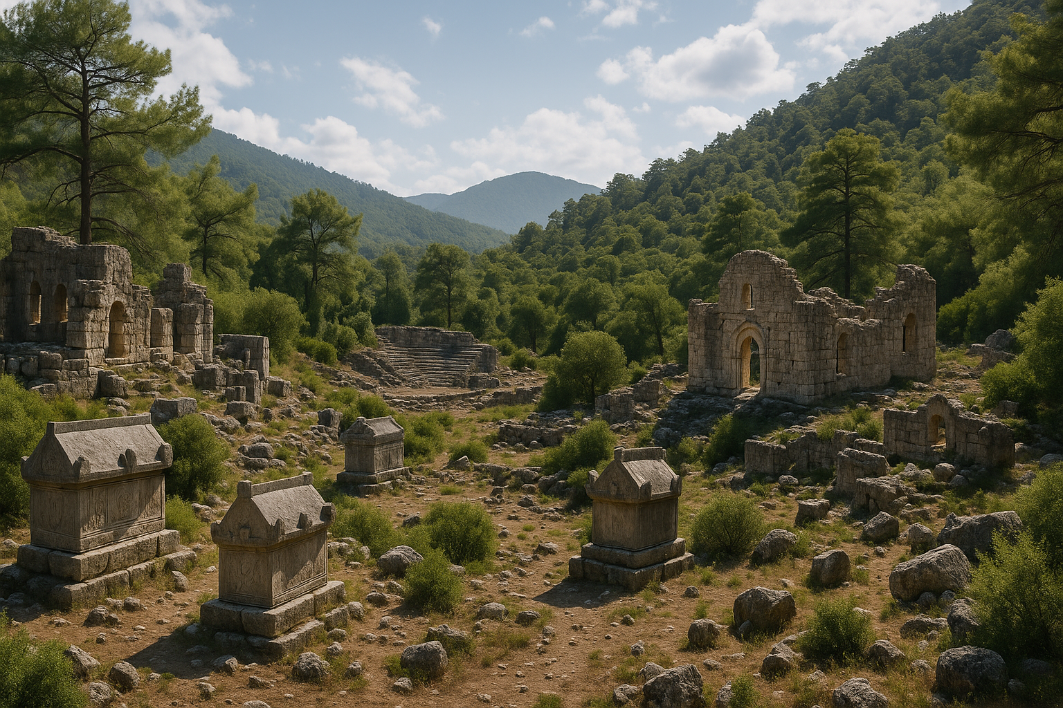
كيتانورا كانت مدينة ليقية قديمة تتربّع فوق قمة تلّ وعرة قرب قرية سراييجيك، في منطقة كوملوجا بولاية أنطاليا. لم تُذكر في أي مصدر أدبي قديم، وظلّت هويّتها مجهولةً لأكثر من 150 عامًا بعد أن رصد آثارها لأول مرة سبرات وفوربس عام 1842. وفي عام 1998 فقط كشفت العملات المعدنية في متحف أنطاليا وحجر الميل ميلياريوم ليسياي من باتارا عن اسمها أخيرًا. استُطلع الموقع بالتفصيل من قِبَل نفزات جيفيك من جامعة أكدينيز بين عامَي 2004 و2007، وتشتهر كيتانورا بـهيرون تروكونداس الثاني الضخم — أحد أفضل المقابر البطولية المحفوظة في جنوب آسيا الصغرى — وبـمقبرتها المتكاملة المؤلّفة من 51 تابوتًا حجريًا. يبقى الموقع من أكثر المدن الليقية أصالةً وأقلّها زيارةً، إذ يُتيح تجربةً أثرية برية حقيقية.
جدول المحتويات
- لماذا تُعدّ كيتانورا مهمة
- الجغرافيا والموقع
- الجدول الزمني التاريخي
- المعالم الأثرية الكبرى
- هيرون تروكونداس الثاني
- المقبرة
- الأعمال الأثرية
- معلومات الزيارة
- الأسئلة الشائعة
- المصادر وقراءات إضافية
لماذا تُعدّ كيتانورا مهمة
-
مدينة استُعيدت من النسيان: على خلاف المواقع الليقية الشهيرة كزانثوس أو ميرا، لم تُذكر كيتانورا قطّ على يد أي كاتب قديم — لا سترابو ولا بلينيوس ولا بطليموس ولا أي جغرافي أو مؤرّخ آخر. جاء التعرّف على هويّتها كلّيًا عن طريق العمل الاستقصائي الأثري — عملات معدنية وحجر ميل روماني ومسح منهجي. وهذا ما يجعلها نموذجًا بارزًا على قدرة علم الآثار الحديث في استعادة تواريخ أهملها التراث الأدبي كلّيًا.
-
هيرون تروكونداس الثاني: هذا الضريح الضخم بلوحاته البارزة التي تصوّر مشاهد عسكرية وأسطورية، يُعدّ من أرقى نماذج العمارة الجنائزية الليقية خارج المدن الكبرى. ويوفّر دليلًا بالغ الأهمية على فهم كيفية تمثيل النخب الليقية الإقليمية لأنفسها وإنجازاتها عبر الفن المعماري، حتى في مستوطنات صغيرة نائية.
-
مقبرة متكاملة: مع 51 تابوتًا حجريًا وأربعة مقابر من طراز الإكسيدرا متمركزة في منطقة صغيرة نسبيًا، تُقدّم مقبرة كيتانورا صورةً نادرة الاكتمال لممارسات الدفن الليقية عبر عدة قرون. ويعكس التنوع من التوابيت الحجرية البسيطة إلى التوابيت المزخرفة بعناية التسلسلَ الاجتماعي الكامل لمجتمع ليقي صغير.
-
عمارة دفاعية تمتدّ ألف عام: أسوار المدينة الممتدة من الحقبة الهلنستية إلى البيزنطية، وتحوّل الأكروبول إلى معسكر حصين بيزنطي، يُوضّحان كيف تكيّفت مستوطنة جبلية صغيرة في دفاعاتها عبر ألف عام من التهديدات العسكرية ومتطلّباتها المتغيّرة.
-
تجربة بعيدة عن الطرق السياحية المطروقة: تبقى كيتانورا من أقل المدن الأثرية زيارةً في ليقيا، إذ تُتيح تجربة أثرية أصيلة بلا حشود ولا مكاتب تذاكر ولا مرافق حديثة — تناقض حقيقي مع المواقع السياحية المجاورة كأولمبوس أو فاسيليس. يُكافَأ الزوار الذين يبذلون الجهد للوصول إلى كيتانورا بإحساس الاكتشاف الذي نادرًا ما تستطيع المواقع الأثرية المتوسطية تقديمه بعد.
-
عضوية مؤكّدة في الرابطة الليقية: إدراج كيتانورا في حجر الميل ميلياريوم ليسياي في باتارا يؤكّد أن هذه المدينة الجبلية الصغيرة كانت عضوًا معترفًا به في النظام الفيدرالي الليقي، وهو واحد من أكثر التجارب تطوّرًا في التمثيل الحكومي في العالم القديم.
الجغرافيا والموقع
تحتل كيتانورا موضعًا درامًيًا فوق قمة تلّ في جبال بي (بي داغلاري)، الذراع الغربية لسلسلة جبال طوروس التي تُحدّد الطابع الليقي للمشهد الطبيعي. يقع الموقع شمال غرب كوملوجا الحديثة، وهي بلدة تجارية على السهل الساحلي لأنطاليا، على ارتفاع منح مزايا دفاعية طبيعية لكنه استلزم جهدًا كبيرًا للوصول إليه.
يجلس الأكروبول على تلّة تمتدّ في اتجاه شرقي-غربي. تحمي الجانبَين الغربي والشمالي جروف صخرية شاهقة تنحدر بصورة حادة، مما يجعل المدينة مستعصيةً طبيعيًا من تلك الجهات. تمتدّ أسوار التحصين من الجانب الجنوبي الغربي حول الأجناب الشرقية والشمالية، لتُحيط بمنطقة الاستيطان وتُكمل الدائرة الدفاعية حيث لم تُوفّر الطبيعة حواجزها.
تتسم التضاريس بطابع ليقيا الداخلية النموذجي:
- منحدرات كلسية صخرية مكسوّة بغابات ضاحلة متوسطية — عطرية شاملة آسًا وضرو وزعترًا بريًا وإكليل جبل
- جداول موسمية (غالبًا ما تجفّ في الصيف) في الأودية أسفل التلال، تُوفّر الماء في الأشهر الرطبة
- أراضٍ زراعية مدرّجة على المنحدرات اللطيفة، دليلٌ على أن السكان القدماء زرعوا منهجيًا سفوح التلال
- غابات الصنوبر والأرز في المرتفعات الأعلى، مصدر الخشب للبناء والوقود
قد يشتق اسم "كيتانورا" من اللغة الليقية، ربما بمعنى "المدينة الصغيرة" — وصف ملائم لهذه المستوطنة المتراصّة ذات الموقع الاستراتيجي المحكم. وقد يُردّد اسم القرية الحديثة سراييجيك ("القصر الصغير") ذكريات شعبية للآثار الضخمة المرئية فوق التلّة.
من الأكروبول تمتدّ الأنظار عبر المشهد الجبلي المحيط نحو الساحل المتوسطي، مما يوفّر قدرة مراقبة استراتيجية على مسالك الاقتراب وبانوراما طبيعية خلّابة. في الأيام الصافية، تبدو الخطوط الزرقاء للبحر الأبيض المتوسط جنوبًا، فيما ترتفع قمم جبال بي الوعرة شمالًا وغربًا.
يمرّ الطريق المُقترب من المدينة القديمة من الجنوب عبر المقبرة قبل بلوغ الأكروبول، مما يعني أن الزوار القدماء كانوا يسيرون بين التوابيت وهيرون تروكونداس قبل دخولهم المدينة الحية — ترتيب متعمّد شائع في التخطيط العمراني الليقي يُبقي الموتى حُرّاسًا بصريين على عتبة المجتمع.
الجدول الزمني التاريخي
الحقبة الهلنستية (القرن الثالث - الأول قبل الميلاد)
يعود أقدم طور محدَّد الهوية في كيتانورا إلى الحقبة الهلنستية. شُيّد الطور الأول من أسوار المدينة في هذه الحقبة بأسلوب البناء المضلّع المميّز للعمارة الدفاعية الليقية. ويُرجَّح أن المستوطنة عملت مجتمعًا محصّنًا صغيرًا يُسيطر على ممرات جبلية وأراضٍ زراعية محلية في المناطق الداخلية الوعرة من ليقيا.
في هذه الحقبة تنازعت كلٌّ من إمبراطورية البطالمة والإمبراطورية السلوقية على ليقيا قبل أن تنال قدرًا من الاستقلالية عبر الرابطة الليقية، إحدى أقدم الأنظمة الفيدرالية وأكثرها إعجابًا في العالم القديم. منحت الرابطة التي أثنى عليها سترابو لعدالتها وتنظيمها، المدنَ الأعضاءَ حق إيفاد ممثلين إلى جمعية فيدرالية بما يتناسب مع حجمها. ويُؤكَّد انتساب كيتانورا إلى الرابطة بورودها على ميلياريوم ليسياي، حجر ميل روماني نُقّب عنه في باتارا عام 1993 يُدرج مدن الرابطة الليقية والمسافات بينها.
خصّصت الرابطة الليقية للمدن الأعضاء صوتًا أو صوتين أو ثلاثة وفق حجمها. بوصفها مستوطنة صغيرة، احتفظت كيتانورا على الأرجح بصوت واحد، غير أن إدراجها يُثبت مشاركة حتى المجتمعات الجبلية المتواضعة في هذا النظام الحكومي الفيدرالي المتطوّر.
الحقبة الرومانية (القرن الأول قبل الميلاد - القرن الرابع الميلادي)
في ظل الإدارة الرومانية شهدت كيتانورا أعظم مراحل بناء صروحها. شُيّد هيرون تروكونداس الثاني في العقود الثاني إلى الرابع من القرن الثاني الميلادي (تقريبًا 120-140 م)، في ذروة الازدهار الإمباطوري الروماني في ليقيا. أُقيم مجمّع الحمام والصالة الرياضية في موعد لا يتجاوز القرن الثاني الميلادي، وتوسّعت المقبرة توسّعًا ملحوظًا بتوابيت جديدة بأسلوبَي ليقي وروماني.
سكّت المدينة عملاتها الخاصة في هذه الحقبة، وقد كُشف عن أمثلة منها في مجموعة متحف أنطاليا عام 1998 — الاكتشاف الرئيسي الذي أفضى إلى التعرّف على الموقع بعد 150 عامًا من إخفاء هويّته.
شملت البنية التحتية الرومانية:
- مجمّع الحمام والصالة الرياضية بوحداته السبع وملعب البالايسترا للتدريب الرياضي
- أسوار تحصين موسّعة تشمل تقنيات البناء الرومانية
- الهيرون وحرمه الجنائزي المرتبط به
- مبانٍ سكنية جنوب الأكروبول وغربه
- منظومة الطرق الرابطة بالشبكة الإقليمية للنقل
كانت الحقبة الرومانية ذروة تطوّر كيتانورا، حين شاركت حتى هذه المدينة الجبلية الصغيرة في الازدهار العام وثقافة البناء الصرحي التي طبعت الشرق الروماني في القرن الثاني الميلادي.
الحقبة البيزنطية (القرن الخامس - السابع الميلادي)
في العهد البيزنطي خضعت كيتانورا لتحوّل جذري. أُقيمت كنيسة من القرن الخامس أو السادس الميلادي فوق الأكروبول، محوّلةً وظيفة القمة الأولية من مركز إداري مدني إلى فضاء للعبادة المسيحية. وفي الوقت ذاته حُوّلت القمة إلى قسطرة (حصن عسكري مسوَّر) بدفاعات معزَّزة، وهو ما يعكس المخاوف الأمنية المتصاعدة في تلك الحقبة مع تهديد الغارات العربية للساحل المتوسطي وليقيا الداخلية.
هذا النمط المتمثّل في تحويل مدن العصر الكلاسيكي إلى حصون بيزنطية شائع في أرجاء ليقيا، ويعكس تقلّص أنماط الاستيطان من المدن المفتوحة المتناثرة في الحقبة الرومانية إلى مواضع مرتفعة محصّنة ومنيعة. حلّت الكنائس محلّ المعابد، وحلّت الحصون محلّ الأغوراس.
يعود الطور الأخير من أسوار المدينة إلى هذه الحقبة، إذ يمثّل آخر جهد بنائي كبير في الموقع.
الهجر
كسائر المستوطنات الليقية الداخلية، هُجرت كيتانورا في نهاية المطاف مع تمركز السكان في المدن الساحلية والمراكز الكبرى. لا يُعرف التاريخ الدقيق للهجر، لكنه وقع على الأرجح بعد القرن السابع، في حقبة تسبّبت فيها الغارات العربية والأوبئة والاضطرابات الاقتصادية في إفراغ ليقيا الداخلية من سكّانها على نطاق واسع. ربما انتقل السكان إلى الساحل في كوملوجا أو إلى مستوطنات أكبر في المنطقة.
بعد الهجر استعاد النبات الجبلي الموقع تدريجيًا، وبقيت أسواره وتوابيته الحجرية صامتةً بين الصنوبر لأكثر من ألف عام حتى أعاد المستكشفون الأوروبيون اكتشافها في القرن التاسع عشر.
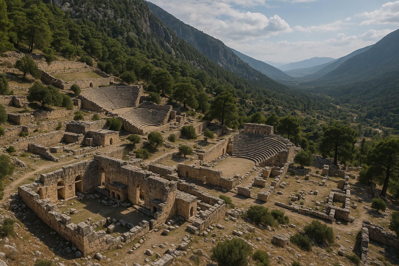
المعالم الأثرية الكبرى
الأكروبول
يتوّج الأكروبول قمة التلّة ذات الامتداد الشرقي الغربي، وأدّى دور القلب الدفاعي والمركز الإداري الديني للمدينة. تشمل معالمه الرئيسية:
- دفاعات الجروف الطبيعية على الجانبين الغربي والشمالي، توفّر حمايةً مستعصيةً
- أسوار التحصين الممتدة من الجنوب الغربي نحو الشرق والشمال، مُكمِّلةً المحيط الدفاعي
- كنيسة بيزنطية (القرن الخامس-السادس م) أُقيمت على القمة خلفًا للمنشآت المدنية السابقة
- تحصينات القسطرة البيزنطية التي عزّزت الأسوار السابقة بتقنيات بناء جديدة
- بقايا منشآت سكنية وعامة داخل المنطقة المسوّرة، تشمل مبانٍ إدارية محتملة
يُتيح الأكروبول أفضل منظور لفهم علاقة المدينة بمحيطها الجغرافي والمنطق الاستراتيجي لموقعها — مُسيطرةً على الطرق الجبلية مع الحفاظ على الاتصال البصري مع مستوطنات ليقية أخرى.
أسوار المدينة
تطوّرت تحصينات كيتانورا عبر ثلاثة أطوار رئيسية على الأقل:
- الطور الهلنستي: أسوار من البناء المضلّع، أقدم دائرة دفاعية. هذه الأسوار المبنية من كتل حجرية غير منتظمة ملائمة بعناية تُجسّد الجودة العالية للعمارة العسكرية الليقية. يُوجد الأسلوب المضلّع — حيث يُشكَّل كلّ حجر منفردًا ليلائم جيرانه — بنيةً متشابكة ذات صلابة استثنائية.
- الطور الروماني: أسوار موسّعة ومعزَّزة تشمل تقنيات بناء جديدة بما فيها بناء بالمداميك المنتظمة أكثر
- الطور البيزنطي: التدعيم الأخير وتحويل الأكروبول إلى قسطرة بأسوار أسمك ومداخل معدَّلة
الأسوار في أفضل حالة حفظها على الجانبين الجنوبي والشرقي حيث التضاريس الطبيعية أقلّ انحدارًا. قطاعات البناء المضلّع جديرة بالملاحظة بصفة خاصة لجودتها الإنشائية، وقد وثّقها الفريق المسحي بالتفصيل.
مجمّع الحمام والصالة الرياضية
يقع خارج منطقة الأكروبول، وأُقيم هذا المجمّع على الأرجح في موعد لا يتجاوز القرن الثاني الميلادي. يتألّف من:
- سبع وحدات وظيفية منفصلة (تشمل على الأرجح الفريجيداريوم والتيبيداريوم والكالداريوم وغرف الخدمات والأفران)
- بالايسترا (فناء التمارين) للتدريب الرياضي والتجمّع الاجتماعي
- أدلة على أنظمة تدفئة (هيبوكوست) نموذجية للعمارة الرومانية للحمامات، بأرضيات مرفوعة وقنوات جدارية لتوزيع الهواء الساخن
أدّى هذا المجمّع دور المحور الاجتماعي للمجتمع، إذ عمل ليس مرفق استحمام فحسب بل مكانًا للتمارين والتواصل الاجتماعي والتفاعل المدني — نسخة مصغّرة من مجمّعات الحمام والصالة الرياضية الضخمة الموجودة في المدن الليقية الكبرى كباتارا أو ميرا. يُجسّد وجوده في هذه المستوطنة الصغيرة جذورَ الثقافة المدنية الرومانية في أبعد أركان الإمبراطورية عمقًا.
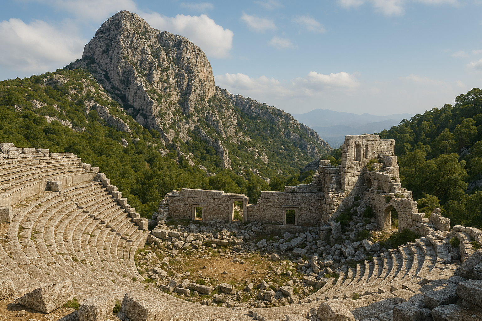
هيرون تروكونداس الثاني
أشهر معالم كيتانورا هو هيرون تروكونداس الثاني، ضريح ضخم أُقيم على المنحدر أعلى الطريق الموصل إلى المدينة. يستحقّ هذا البناء اهتمامًا تفصيليًا لكونه يُقدّم رؤى فريدة في ثقافة النخبة بليقيا الإقليمية، ويُعدّ من أفضل الهيرونات المحفوظة في جنوب آسيا الصغرى.
العمارة
للهيرون تصميم على شكل معبد يذكّر بـهيرون بيريكلي في ليميرا، أحد أشهر المعالم في ليقيا. يقيس المبنى المستطيل نحو 8.35 × 7.2 متر تقريبًا. مفرداته المعمارية — أعمدة وإفريز وجملون — تستحضر عمدًا العمارة المقدسة لترفع مكانة المتوفّى من بشر إلى بطل. كان اختيار شكل المعبد إفصاحًا قويًا: إذ ادّعى لصاحب الضريح مكانةً تقترب من الإلهية.
يقوم المبنى فوق منصّة مرتفعة تُعظّم رؤيته وبروزه على امتداد طريق الوصول إلى المدينة. الزوار القادمون إلى كيتانورا من الجنوب كانوا يصادفون الهيرون كأحد أولى المنشآت الضخمة التي تقع أعينهم عليها، مُرسِّخًا انطباعًا راسخًا بقوة عائلة تروكونداس ومكانتها.
النقش
وفقًا للنقش الموجود على واجهة الضريح، أقام المعلمَ تروكونداس بن تروكونداس حفيد أتيوس لنفسه. اسم العائلة تروكونداس ليقيّ الطابع بامتياز، مما يدلّ على هوية نخبة أصيلة لا على الاندماج الثقافي اليوناني الروماني. وهذا أمر لافت: حتى في القرن الثاني الميلادي حين كانت ليقيا معظمها هلّنست بالكامل، حافظت الأسرة الحاكمة في كيتانورا على اسم راسخ في اللغة الليقية، مُؤكِّدةً الاستمرارية مع تقاليد الأناضول ما قبل الإغريقية.
الزخارف البارزة
زُيّن خارج الهيرون بـكتل بارزة منحوتة تصوّر:
- مشاهد عسكرية: محاربون في معارك، ربما تُمثّل إنجازات الراعي الحقيقية أو المثالية في الحرب. تُشير هذه المشاهد إلى أن نخبة كيتانورا اشتقّت مكانتها من الخدمة العسكرية، ربما في قوات المساعدة الرومانية.
- مشاهد أسطورية: شخصيات من الميثولوجيا الإغريقية تُجسّد مزج التقاليد الثقافية الليقية والهلنستية. إدراج الأساطير الإغريقية في معلَم يحمل اسمًا ليقيًا يُجسّد التهجين الثقافي لليقيا في الحقبة الرومانية.
- زخارف رمزية: عناصر مرتبطة بالمكانة البطولية والحياة الآخرة، من أكاليل ودروع وأسلحة
تعكس النقوش البارزة الطابع العسكري للمدينة ونخبتها، مُشيرةً إلى أن الأسر الحاكمة في كيتانورا استمدّت هيبتها من الخدمة المسلّحة — ربما بوصفها جنودًا أو ضبّاطًا في الجيوش الرومانية. جودة النحت، وإن لم تبلغ مستوى الورش الكبرى في المدن الرئيسية، تكشف عن حرفة إقليمية مُتقنة.
التأريخ
وضع البحث الأكاديمي الأخير تشييد الهيرون في العقود الثاني إلى الرابع من القرن الثاني الميلادي (تقريبًا 120--140 م)، في ذروة الازدهار الإمباطوري الروماني في ليقيا. هذا التأريخ المعدَّل المنشور في مجلة "Actual Problems of Theory and History of Art" استند إلى تحليل دقيق للمقارنات المعمارية والأسلوبية مع معالم مؤرَّخة أخرى في ليقيا وبامفيليا.
الأهمية
يكتسب هيرون تروكونداس الثاني أهمّيته لأنه يُظهر أن النخب المحلية حتى في مدينة ليقية صغيرة نائية كانت تستثمر بكثافة في التمثيل المعماري الصرحي لذواتها. يُجسّد اختيار التصميم المعبدي والزخارف البارزة المعقّدة وعيًا ثقافيًا راقيًا والرغبة في المشاركة في التقاليد الجنائزية اليونانية الرومانية الأشمل مع الإبقاء على علامات هوية ليقية مميّزة. وهو يُكذّب أي رواية مبسَّطة تصف ليقيا الإقليمية بكونها مجرّد متلقٍّ سلبي للثقافة العاصمية.
المقبرة
تنتشر مقبرة كيتانورا عبر المنحدرات المحيطة بالمستوطنة، متمركزةً على طول الطرق المؤدية إلى المدينة، وتحتوي على:
- 51 تابوتًا حجريًا: توابيت حجرية بالغطاء المدبَّب الليقي المميّز (بانحنائه القوسي المميّز)، فضلًا عن نماذج ذات غطاء مسطّح من الحقبة الرومانية. تتراوح بين صناديق حجرية سادة عارية الزخرفة وأمثلة منحوتة بعناية فائقة.
- 4 مقابر من طراز الإكسيدرا: مقابر من المقاعد النصف دائرية استُخدمت للوليمة الجنائزية والتأبين — وفّرت هذه المنشآت مقاعد للمحزونين الذين يتجمّعون لتناول وجبات التذكّار، وهي عادة راسخة عمقًا في الثقافة الجنائزية الليقية واليونانية الرومانية.
- مقابر منحوتة في الصخر: محفورة في وجوه الجروف على المنحدرات الشمالية والغربية، مستغلّةً البروزات الصخرية الطبيعية
- قبور حفرة بسيطة: دفنات أكثر تواضعًا لعامة السكان، خاليةً من التوابيت الحجرية الباهظة للمقيمين الأثرياء
تُظهر التوابيت الحجرية مستويات متفاوتة من الزخرفة، من التوابيت السادة غير المزخرفة إلى نماذج منحوتة بعناية بلوحات بارزة وأكاليل ورؤوس ثور ونقوش. يعكس هذا التنوّع التدرّج الاجتماعي للمجتمع — من الأسر الثرية التي اقتدرت على مقابر صرحية إلى المقيمين الأكثر تواضعًا المدفونين في قبور بسيطة.
يتّبع نمط توزيع المقبرة الأسلوب الليقي المعهود: التوابيت موضوعة على امتداد الطرق المؤدية إلى المدينة، ضمانًا لبقاء الموتى جزءًا من المشهد البصري اليومي للمجتمع. في كلّ مرة مشى فيها مسافر أو مقيم إلى كيتانورا أو خرج منها، كان يعبر بين الموتى، محافظًا على الرابط بين الأحياء وأسلافهم.
الأعمال الأثرية
الاكتشاف الأول (1842)
سجّل آثار سراييجيك لأول مرة المستكشفان البريطانيان ت. أ. ب. سبرات وإدوارد فوربس خلال مسحهما لليقيا عام 1842. أسفرت بعثتهما التي امتدّت سنوات عن المنشور الرائد Travels in Lycia, Milyas, and the Cibyratis الذي وثّق عشرات المواقع القديمة في المنطقة. بيد أنهما لم يتمكّنا من تحديد هوية المدينة القديمة في سراييجيك. خلال المئة والخمسين عامًا التالية ظلّت الآثار مجهولة الهوية في الأدبيات العلمية، معروفةً فحسب بـ"الموقع الأثري القديم قرب سراييجيك".
التعرّف على الهوية (1998)
جاء الاختراق عام 1998 حين كشفت دراسة عملات في مجموعة متحف أنطاليا عن نماذج تحمل النقش "كيتانورا". وبمقارنة هذا النقش مع ميلياريوم ليسياي — حجر ميل روماني نُقّب عنه في باتارا عام 1993 بإشراف الأستاذة هافا إيسكان-إيشيك والذي يُدرج المسافات بين مدن ليقيا — تمكّن الباحثون من تحديد موقع كيتانورا في آثار سراييجيك. المسافة المسجّلة على حجر الميل تطابقت مع موضع سراييجيك نسبةً إلى مدن معروفة، مما أكّد التعرّف على الهوية.
كانت هذه لحظة بالغة الأهمية في الدراسات الليقية: مدينة قديمة غائبة كلّيًا عن السجلّ الأدبي جرى التعرّف عليها بمحض الجمع بين الدليل النقدي والدليل الكتابي.
المسح المنهجي (2004--2007)
أُجري مسح أثري تفصيلي بين عامَي 2004 و2007 من قِبَل فريق جامعة أكدينيز بقيادة الأستاذ نفزات جيفيك. أنتج هذا المسح:
- رسمًا شاملًا لجميع المنشآت المرئية باستخدام معدّات المساحة الحديثة
- توثيقًا للمقبرة وتوابيتها الحجرية الـ51، شاملًا القياس والتصوير ورسم كلّ معلَم
- تحليلًا معماريًا للهيرون والأسوار ومجمّع الحمام والكنيسة
- دليلًا خزفيًا ونقديًا لتأريخ مراحل الاحتلال
- توثيقًا فوتوغرافيًا ومرسومًا للنحوت البارزة على الهيرون
- جردًا كاملًا لمعالم الموقع وحالة حفظها
المنشورات الأكاديمية
نُشر البحث في كيتانورا في مجلّات أكاديمية متخصّصة:
- دراسات حول هيرون تروكونداس بالفرنسية والإنجليزية في مجلّات أثرية، شاملة تحليلات دلالته السياسية والاجتماعية والثقافية لفهم ثقافة النخبة الليقية الإقليمية
- التأريخ المعدَّل للهيرون المنشور في "Actual Problems of Theory and History of Art"
- تقارير المسح تغطّي تخطيط المدينة وجرد المعالم والتصنيف المعماري
- دراسات مقارنة تضع كيتانورا في السياق الأشمل للحضرية الليقية والجغرافيا الإدارية للرابطة الليقية
معلومات الزيارة
الموقع: قرب قرية سراييجيك، شمال غرب كوملوجا، ولاية أنطاليا. الموقع في الجبال فوق السهل الساحلي على ارتفاع كبير فوق سطح البحر.
الوصول إلى الموقع:
- من كوملوجا: السير شمالًا غربًا نحو قرية سراييجيك (نحو 20--25 كم). الجزء الأخير يستلزم طريقًا ترابيًا/حصويًا قد يكون وعرًا في بعض المقاطع.
- من أنطاليا: السير على الطريق السريع D400 جنوبًا غربًا نحو كوملوجا (نحو 100 كم) ثم اتّباع الطرق المحلية نحو سراييجيك.
- يُنصح باستخدام سيارة ذات خلوص أرضي مناسب للمقطع الأخير من الطريق. السيارات العادية تعبر في العادة في الطقس الجاف، لكن يُفضّل استخدام الدفع الرباعي شتاءً أو بعد المطر.
- لا توجد وسائل نقل عامة إلى الموقع؛ يستلزم الوصول مركبةً خاصة.
أفضل وقت للزيارة:
- الربيع (أبريل--يونيو): الأزهار البرية في عزّ ازدهارها على المنحدرات الجبلية، درجات حرارة معتدلة، رؤية ممتازة. هذا هو الموسم المثالي.
- الخريف (سبتمبر--نوفمبر): طقس مريح، إضاءة ذهبية مثالية للتصوير، هواء جبلي بارد منعش بعد حرارة الصيف
- الصيف ممكن لكنه شديد الحرارة؛ الزيارات الصباحية المبكّرة ضرورية. ابدأ قبل الساعة الثامنة صباحًا لتجنّب الحرارة الشديدة.
- قد يجلب الشتاء أمطارًا وبردًا وطرقًا وصول موحلة محتملة على الارتفاع الجبلي
المدة الزمنية:
- زيارة معيارية (الأكروبول والهيرون والجولة في المقبرة): 1.5--2.5 ساعة
- زيارة تفصيلية مع التصوير والاستكشاف الشامل: 3--4 ساعات
- احسب وقتًا إضافيًا للقيادة على الطرق الجبلية (30-45 دقيقة من كوملوجا)
ما تحمله معك:
- حذاء مشي متين (ضروري — التضاريس صخرية وغير مستوية وشديدة الانحدار في بعض المقاطع)
- ما لا يقلّ عن 1.5 لتر من الماء للفرد (أكثر في الصيف)
- واقٍ من الشمس (قبّعة وكريم وقاية) — الغطاء الشجري محدود في بعض المناطق
- مصباح يدوي أو كشّاف رأسي لفحص المقابر المنحوتة في الصخر
- وجبات خفيفة — لا توجد مرافق في الموقع أو بالقرب منه
- كاميرا بقدرة تكبير جيدة لتوثيق تفاصيل النقوش البارزة على الهيرون
ملاحظات مهمة:
- لا توجد مكاتب تذاكر ولا مراكز زوّار ولا مرافق في كيتانورا
- الموقع غير مؤمَّن وغير مسيَّج — توخَّ الحذر الشديد على حواف الجروف، لا سيما على الجانبين الشمالي والغربي من الأكروبول
- استقبال الهاتف المحمول قد يكون محدودًا أو معدومًا في البيئة الجبلية
- أخبر شخصًا ما بخططك للزيارة، خاصةً إن كنت تسافر منفردًا
- احترم الآثار الأثرية — لا تتسلّق التوابيت أو الأسوار أو هيكل الهيرون
- خذ قمامتك معك؛ لا تترك أثرًا لزيارتك
المواقع القريبة:
- أولمبوس (المدينة القديمة والشاطئ، نحو 40 كم جنوبًا شرقيًا) — مدينة ليقية درامية على الجرف الصخري مع آثار من الحقبة الرومانية وكيمايرا، نيران الشعلة الأبدية
- فاسيليس (نحو 55 كم شرقًا) — ثلاثة موانئ وآثار مظلّلة بالصنوبر
- ليميرا (نحو 30 كم شمالًا شرقيًا) — قارن هيرون بيريكلي مع ضريح تروكونداس في دراسة تقارنية للعمارة البطولية الليقية عبر القرون
- أريكاندا (نحو 45 كم شمالًا) — مدينة ليقية مدرّجة خلّابة في الجبال
- ميرا وكنيسة القدّيس نيقولاوس في دمري (نحو 60 كم جنوبًا غربيًا) — مقابر منحوتة في الصخر وموروث بيزنطي
الأسئلة الشائعة
لماذا تبقى كيتانورا مجهولة مقارنةً بالمدن الليقية الأخرى؟
لأن أي كاتب قديم لم يذكرها قطّ. مدن كزانثوس وباتارا وميرا تظهر مرارًا في المصادر الأدبية الإغريقية والرومانية، مما يستقطب اهتمامًا أكثر حداثةً بطبيعة الحال. كيتانورا جرى التعرّف عليها في عام 1998 فحسب عبر الدليل الأثري، ولم تُحفَر قطّ رسميًا — مُسحت فقط. نأيها الجبلي أيضًا يُبقيها بعيدةً عن خطوط الرحلات السياحية الاعتيادية.
هل هيرون تروكونداس محفوظ كاملًا؟
يبقى الهيرون في حالة خراب جزئي. الجدران السفلية وكثير من الزخارف البارزة محفوظة، لكن الهيكل العلوي (السقف والجملون) انهار. ما تبقّى يكفي للتقدير الكامل للتصميم الأصلي لهذا البناء وجودة برنامجه النحتي. النقوش البارزة على الكتل الباقية لا تزال واضحة المعالم وتجعل صعود التلّة جديرًا بالعناء.
كم عدد سكّان كيتانورا؟
لا يوجد تقدير دقيق للسكان، لكن استنادًا إلى مساحة المستوطنة وحجم المقبرة والمقارنة مع مدن ليقية مماثلة، تراوح عدد السكان على الأرجح بين 500 و1500 نسمة في ذروته خلال الحقبة الرومانية. كان هذا مجتمعًا صغيرًا بأي معيار، مما يجعل عمارته الصرحية مدهشة بقدر أكبر.
هل يمكنني زيارة كيتانورا دون مرشد؟
نعم، لكن الإعداد مهم. لا توجد لوحات إرشادية ولا مسارات مُعلَّمة في الموقع. دراسة مخطط الموقع مسبقًا وإحضار جهاز GPS أو خرائط غير متصلة بالإنترنت وارتداء حذاء مناسب ستُحسِّن تجربتك تحسينًا ملحوظًا. الآثار منتشرة على منحدر تلّة وتتطلّب جهدًا جسديًا معتدلًا لاستكشافها. مرشد مُلمّ بالمعرفة المحلية يستطيع تعزيز الزيارة تعزيزًا كبيرًا.
ما العلاقة بين كيتانورا والرابطة الليقية؟
تظهر كيتانورا على ميلياريوم ليسياي، حجر الميل الروماني من باتارا الذي يُدرج مدن الرابطة الليقية والمسافات بينها. هذا يؤكّد أن كيتانورا كانت عضوًا معترفًا به في النظام الفيدرالي الليقي، رغم كونها مدينة صغيرة. الرابطة الليقية التي أثنى عليها مونتسكيو وآباء الأمة الأمريكيون نموذجًا للحكم التمثيلي، ضمّت حتى المستوطنات الصغيرة في عملياتها القرارية.
هل توجد قطع أثرية من كيتانورا في المتاحف؟
عملات كيتانورا محفوظة في مجموعة متحف أنطاليا. قطع منقولة أخرى قد تكون في مخازن المتحف أيضًا. كتل النقوش البارزة من الهيرون لا تزال في موضعها في الموقع، مُعرَّضةً للعوامل الطبيعية.
هل هذه رحلة مشي جيدة؟
تجمع الرحلة إلى كيتانورا الاهتمام الثقافي والطبيعي. المشهد الجبلي خلّاب، والأزهار البرية رائعة في الربيع، والإحساس بالوصول إلى مدينة قديمة نائية حقًا مجزٍ. بيد أنه ليس ممشًى مُهيَّأ ومُعلَّمًا — توقّع تضاريس وعرة وحاجة إلى مهارات الملاحة.
القياسات المعمارية والأرقام الرئيسية
يجمع الجدول التالي الأبعاد الموثّقة الرئيسية والإحصاءات الخاصة بمعالم كيتانورا استنادًا إلى تقارير المسح لجامعة أكدينيز والدراسات الأكاديمية المنشورة.
| الخاصية | القياس / الكمية |
|---|---|
| أبعاد قاعدة هيرون تروكونداس الثاني | 8.35 × 7.2 م |
| تأريخ الهيرون (المعدَّل) | نحو 120--140 م (العقود الثاني إلى الرابع من القرن الثاني) |
| إجمالي التوابيت الحجرية في المقبرة | 51 |
| مقابر طراز الإكسيدرا | 4 |
| الوحدات الوظيفية لمجمّع الحمام والصالة الرياضية | 7 (بالايسترا + 6 أقسام استحمام/خدمات) |
| كنائس بيزنطية محدَّدة في الموقع | 5 |
| تقدير ذروة عدد السكان | 500--1500 نسمة |
| فترة المسح | 2004--2007 |
| سنوات بقاء الموقع مجهول الهوية | 156 (1842--1998) |
الدليل النقدي وتعرّف عام 1998
السجلّ النقدي لكيتانورا صغير لكنه حاسم تاريخيًا: كانت العملات، لا المصادر الأدبية، هي ما أعاد إلى هذه المدينة اسمها بعد أكثر من ألف عام من الغياب.
عملات التعرّف
في عام 1998 كشفت دراسة منهجية لعملات غير منسوبة في مجموعة متحف أنطاليا عن نماذج برونزية تحمل النقش KITANAYP (كيتانور-) — اسم مدينة لم يسبق أن ظهر في أي نص أدبي قديم. أتاح مقارنة نقوش العملات مع ستاديازموس باتارينسيس (المعروف أيضًا بميلياريوم ليسياي)، عمود حجر ميل روماني نُقّب عنه في باتارا عام 1993 بإشراف الأستاذة هافا إيسكان-إيشيك، للباحثين مطابقةَ المسافة المسجّلة على حجر الميل مع موضع الآثار غير المُعرَّفة في سراييجيك.
ستاديازموس باتارينسيس بحدّ ذاته يُعدّ من أهمّ الوثائق للجغرافيا التاريخية لليقيا القديمة. أُقيم في عهد الإمبراطور كلوديوس (حكم 41--54 م)، ويُسجّل العمود المسافات بالاسطاديون بين المدن الليقية، مُقدِّمًا خريطة طرق للجغرافيا الإدارية للرابطة الليقية. يؤكّد ظهور كيتانورا على هذا المعلَم مكانتها بوصفها عضوًا معترفًا به في النظام الفيدرالي خلال القرن الأول الميلادي.
أنواع العملات
العملات المعروفة من كيتانورا هي إصدارات مدنية برونزية من الحقبة الإمبراطورية الرومانية. وفيما يكون إجمالي النماذج الباقية صغيرًا — ما يعكس الحجم المتواضع للمدينة — فإنها تتّبع النمط الاعتيادي لسكّ عملات الرابطة الليقية:
| الخاصية | الوصف |
|---|---|
| المعدن | برونز |
| النقش | KITANAYP (باليونانية) |
| الوجه | صورة إمبراطورية (الإمبراطور يحتاج تأكيدًا من دراسة تفصيلية) |
| الظهر | إله محلي أو رمز مدني |
| الحقبة | الإمبراطورية الرومانية (القرن الأول - الثالث الميلادي) |
| الموقع الحالي | مجموعة متحف أنطاليا |
ندرة عملات كيتانورا لها دلالتها. في السجلّ النقدي الليقي، كان حجم السكّ المنتَج من قِبَل مدينة ما يرتبط تقريبًا بحجمها وأهميتها الاقتصادية. الإنتاج المحدود لكيتانورا يتّسق مع صغر حجم سكّانها وموقعها الجبلي النائي، بينما يُؤكّد وجود دار سكّ مدنية أن حتى أصغر أعضاء الرابطة الليقية مارست حقّها في إصدار عملتها الخاصة.
ميلياريوم ليسياي وشبكة الطرق الفيدرالية الليقية
يضع إدراج كيتانورا في ميلياريوم ليسياي (ستاديازموس باتارينسيس) المدينةَ داخل أحد أكثر أنظمة الحوكمة التمثيلية إعجابًا في العالم القديم. الرابطة الليقية التي أثنى عليها سترابو (الجغرافيا XIV.3.3) نموذجًا للتمثيل العادل والتناسبي، خصّصت أصواتًا لمدن الأعضاء وفق ثلاث درجات:
| الدرجة | الأصوات | الحجم المعتاد للمدينة |
|---|---|---|
| الدرجة الأولى | 3 أصوات | المدن الكبرى (زانثوس، باتارا، ميرا، تلوس، بينارا، أولمبوس) |
| الدرجة الثانية | صوتان | المدن متوسطة الحجم |
| الدرجة الثالثة | صوت واحد | المدن والبلدات الصغيرة |
بوصفها مستوطنة جبلية صغيرة، احتفظت كيتانورا بالتأكيد تقريبًا بـصوت واحد في الجمعية الفيدرالية. ومع ذلك ضمن هذا الصوت المفرد المشاركةَ في قرارات الرابطة الجماعية في شؤون الحرب والسلام والضرائب وانتخاب الليقيارك (القائد الفيدرالي). دَرَس الآباء المؤسّسون الأمريكيون، ولا سيما جيمس ماديسون، نموذج الرابطة الليقية عند تصميم النظام الفيدرالي للولايات المتحدة، مُلاحِظًا توازنه بين التمثيل التناسبي وإشراك المجتمعات الأصغر.
أطوار أسوار التحصين — تفاصيل تقنية
تُمثّل الأطوار الثلاثة لأسوار كيتانورا تطوّرًا امتدّ ألف عام في العمارة العسكرية في الجبال الليقية.
| الطور | الحقبة | أسلوب البناء | الخصائص |
|---|---|---|---|
| الطور الأول | هلنستي (القرن الثالث - الأول ق.م) | البناء المضلّع | كتل غير منتظمة مشكّلة فرديًا تتشابك دون ملاط؛ صلابة هيكلية عالية جدًا |
| الطور الثاني | روماني (القرن الأول - الثالث م) | بناء بالمداميك المنتظمة | كتل مستطيلة أكثر انتظامًا بمداميك أفقية؛ تبنّي المعايير الهندسية الرومانية |
| الطور الثالث | بيزنطي (القرن الخامس - السابع م) | بناء مختلط من السبوليا | كتل رومانية وهلنستية مُعاد استخدامها ومقرونة ببناء جديد؛ أسوار أسمك ومواضع بوابات معدَّلة |
البناء المضلّع للطور الهلنستي جديرٌ بالملاحظة بصفة خاصة. هذا الأسلوب الذي يُقطَّع فيه كل حجر فرديًا ليلائم جيرانه في نمط فسيفساء غير منتظم، يُنشئ أسوارًا ذات صلابة زلزالية استثنائية — وهو اعتبار مهم في المنطقة الليقية المعرّضة للزلازل. الحجارة المتشابكة تُوزّع الضغط على وجه الجدار بدلًا من تركيزه على طول مفاصل الملاط الأفقية كما يحدث في البناء بالمداميك.
تضمّن التحويل البيزنطي للأكروبول إلى قسطرة ليس فقط تسميك الأسوار بل أيضًا تضييق المداخل وإعادة تموضعها لإنشاء نقاط خنق أكثر منعةً. تشييد خمس كنائس في هذه الحقبة — وهو عدد مرتفع بشكل غير معتاد لمستوطنة بهذا الحجم — يُلمّح إلى أن كيتانورا ربما أدّت دور مركز كنسي إقليمي أو موقع حجّ خلال العصور القديمة المتأخّرة، مما قد يُفسّر الاستثمار الكبير في العمارة الدفاعية لحماية عدد من رجال الدين والحجّاج أكبر مما كان متوقّعًا.
المصادر وقراءات إضافية
- Wikipedia -- Kitanaura
- Lycian Monuments -- Kitanaura
- ArticHaeology -- Kitanaura / Lycia
- Cevik, N. (2004--2007). Survey reports on Kitanaura, Akdeniz University.
- "The Heroon of Trokondas the Second at Kitanaura: Revised Dating" -- Actual Problems of Theory and History of Art. Link
- "L'heroon de Trokondas a Kitanaura" -- Cairn.info. Link
- TripAdvisor -- Kitanaura Ancient City visitor reviews
- Mapcarta -- Kitanaura Map
- Spratt, T.A.B. & Forbes, E. (1847). Travels in Lycia, Milyas, and the Cibyratis. London.
- ResearchGate -- Heroon of Trokondas studies. Link