أني تقوم على مثلث من الحجر البازلتي الداكن فوق وادي نهر أرباتشاي (أخوريان) العميق، حيث تطلّ تركيا الحديثة عبر الهاوية الشاهقة على جمهورية أرمينيا. طوال ما يقرب من أربعة قرون — منذ أن نقل الملك أشوت الثالث حاشيته إليها عام 961 حتى الزلزال المدمّر عام 1319 — حملت هذه الهضبة النائية في شرق الأناضول إحدى أعظم مدن العصور الوسطى على وجه الأرض.
في عهد سلالة بغراتوني (البغراتيين)، تضخّم عدد سكان أني ليبلغ قرابة مئة ألف نسمة، وهو رقم يضعها في مصافّ القسطنطينية وقرطبة والقاهرة، في حين كانت لندن وباريس لا تزالان كتلتين من المنازل الخشبية خلف الأسيجة. وصفها المعاصرون بـ"مدينة الألف كنيسة وكنيسة"، مبالغةً شعريةً تعكس بدقة المشهد الكثيف من القباب المخروطية والأقواس العمياء وجدران الحجر البركاني التي كانت تملأ الهضبة.
كاتدرائيتها المكتملة عام 1001 على يد المعمار تردات — المعمار نفسه الذي أصلح قبة آيا صوفيا إثر زلزال القسطنطينية عام 989 — استخدمت القوس المدبّب والدعامة المركّبة قبل قرن كامل من ظهورهما في كنيسة دير سان دوني. غير أن أني ليست قصةً أرمنيةً خالصة.
بعد أن اقتحم السلطان ألب أرسلان أسوارها عام 1064، شيّد أمراء الشدّاديون مسجد مانوتشهر على حافة الجرف، وجدّد الزاكاريون الجورجيون كنائسها في مطلع القرن الثالث عشر، واشتغل التجار الفرس واليهود والإغريق في أسواقها. دمّر الفرسان المغول المدينة عام 1239، وأسقط الزلزال الكبير عام 1319 ظهرها، فانزلق طريق الحرير جنوبًا.
أدرجت اليونسكو "الموقع الأثري لأني" في قائمة التراث العالمي عام 2016، في اعتراف متأخر بمكانة مكان كاد العالم أن ينساه طوال سبعة قرون تقريبًا.
جدول المحتويات
- لماذا تهمّنا أني
- الجغرافيا والموقع
- الجدول الزمني التاريخي
- أبرز المعالم
- الأهمية المعمارية
- مدينة متعددة الثقافات
- الأعمال الأثرية
- الأرقام والمقاسات
- معلومات للزوار
- أسئلة شائعة
- المصادر وقراءات إضافية
لماذا تهمّنا أني
قليلة هي المواقع الأثرية التي تكثّف في أفق واحد هذا الحجم من الحجج التاريخية والمعمارية والثقافية المتمايزة. فأني في آنٍ معًا عاصمةٌ وملحق كاتدرائية ومسجد جمعة على الحدود ومحطة تجارية على طريق الحرير ومدينةٌ أشباح على حدود موصدة. وفيما يلي النقاط التي تبرر منحها فصلًا مستقلًا في كل دراسة جادة عن أوراسيا في العصور الوسطى.
عاصمة من الطراز الأول في العصور الوسطى
من عام 961 حتى الضمّ البيزنطي عام 1045، كانت أني مقرّ سلالة بغراتوني وعاصمةً سياسية للمملكة الأرمنية التي امتدت في أوسع حدودها من بحيرة سيفان إلى منابع الفرات. وكان تعداد سكانها عند مطلع القرن الحادي عشر — تتراوح التقديرات بين 50,000 و100,000 نسمة — يجعلها واحدةً من نصف دزينة المدن الأكبر في العالم المسيحي.
للسياق: تشير أفضل التقديرات المعاصرة إلى أن لندن عام 1000 كان بها ما يقارب خمسة عشر إلى عشرين ألف ساكن، وباريس ربما خمسة وعشرون ألفًا، وحتى كولونيا أكبر المدن الألمانية آنذاك نحو أربعين ألفًا. لم تتفوق على أني إلا القسطنطينية (نحو ثلاثمائة ألف) والعاصمتان الإسلاميتان الكبيرتان قرطبة والقاهرة. الوقوف على الهضبة اليوم يعني الوقوف على ما كان بالمعنى الديموغرافي لندن أناضولية تعدادها أضعاف مضاعفة.
مختبر معماري متقدم على عصره
كاتدرائية أني (مكتملة 1001) وكنيسة الرسل المقدسين وكنيسة تيغران هونينتس (1215) تعتمد جميعها الأقواس المدبّبة والدعائم المركّبة والدعامات الضلعية قبل قرن كامل من ظهورها في سان دوني في عهد الأب سوجيه. سواء انتقلت هذه الأشكال غربًا مع الصليبيين أم لا، فالأولوية الزمنية لأني غير متنازَع عليها. ومسألة "من اخترع القوطية" ليست ترفًا أكاديميًا، بل هي من أكثر النقاشات سياسيةً في دراسات العصور الوسطى، وأني في قلب الحجة الأرمنية.
مدينة تردات
أني هي مسقط رأس المعمار الوحيد في العصور الوسطى الذي يُنسب إليه بثقة اثنتان من أهم المباني القبوية في قرنه: الكاتدرائية البغراتية هنا، وقبة آيا صوفيا في القسطنطينية التي رمّمها إثر زلزال 989. السلطة عابرة للثقافات التي تنطوي عليها هذه القصة — إمبراطور بيزنطي يستعين عبر الخطوط المذهبية بمعمار أرمني لأن أحدًا في عاصمته لا يجاريه — دليلٌ ثمين على المكانة الحقيقية للهندسة القوقازية في عالم القرن الحادي عشر.
نسيج حضري متعدد الثقافات بالفعل
على امتداد كيلومتر واحد على حافة الوادي تقوم معًا: كاتدرائية بغراتية، ومسجد جمعة شدّادي، وكنيسة أعادها الجورجيون مع جداريات طراز القسطنطينية، وقاعدة هيكل نار زرادشتي، وأسس خانات القوافل التي استقبلت التجار الفرس واليهود والإغريق. هذا التنوع ليس تمنيًا استرجاعيًا بل هو موثَّق في النقوش والطبقات الأثرية: أني هي الصورة الحقيقية لمدينة حدودية في العصور الوسطى.
محطة على الحدود وعقدة على طريق الحرير
جلست أني على الفرع الأشمل الشمالي لطريق الحرير، ذاك الطريق القادم من تبريز عبر ماكو عابرًا نهر أخوريان صاعدًا إلى هضبة الأناضول نحو طرابزون والبحر الأسود. إيرادات الجمارك من هذه الحركة التجارية، لا الزراعة، هي التي موّلت الكاتدرائية والأسوار والقصور. وموت المدينة بعد 1319 لا ينفصل عن تحويل التجارة بعيد المدى نحو الطرق الجنوبية التي تتجاوز القوقاز كليًا.
نموذج اختباري للتراث عابر الحدود
منذ إغلاق الحدود التركية الأرمنية عام 1993، وقفت أني داخل منطقة عازلة مُؤمَّنة عسكريًا، تطلّ على معالم شقيقة على الجانب الأرمني لا يستطيع الزوار المحليون بلوغها. وكان إدراجها في قائمة اليونسكو عام 2016 لذلك ليس اعترافًا بالقيمة المعمارية وحدها، بل أيضًا رسالةً سياسية هادئة: أن التراث الوسيط يمكن إدارته وصيانته وعرضه حتى عبر حدود موصدة.
مشهد طبيعي بالغ الروعة
الهضبة تشبه رأس حربة مائل قليلًا، تسدّها من الشمال سور مزدوج ضخم من البازلت، وتحميها الأودية التي يبلغ عمقها مئتي متر من الجانبين الآخرين. شُبّهت بماتشو بيتشو وبتراء وميسترا، وهو تشبيه مبرر. أني واحدة من تلك الأماكن النادرة التي تتضافر فيها الجغرافيا والتاريخ والعمارة لتبلغ ما يقترب من الإعجاز.
مكان يستوجب المشي
أني ليست موقع "منظر"، لا يمكن استيعابها من صورة واحدة أو من نقطة مرتفعة. الهضبة واسعة بما يكفي لأن يستغرق المشي الكامل حولها أكثر من ساعة، والمباني منتشرة بما يمنع رؤيتها من موقع واحد. تختبئ الكاتدرائية خلف تل من كنيسة تيغران هونينتس، ويقع مسجد مانوتشهر تحت مستوى السوق، والدير لا يظهر حتى تكون على بعد عشرين مترًا منه. تكسب كل معلم بالأقدام، بالتتابع، في مواجهة الريح.
هذه الطبيعة الماشية جزء من هوية أني، وأحد أسباب الشعور بعدم الإشباع بعد الزيارات القصيرة. الزائر لأول مرة الذي يخصص تسعين دقيقة فقط سيرى الكاتدرائية وربما كنيسة تيغران هونينتس وربما المسجد، وسيغادر واثقًا أنه فاته نصف الموقع. وسيكون محقًا. لرؤية أني جيدًا تحتاج إلى نصف يوم على الأقل، ومثاليًا زيارتين تفصل بينهما بضع ساعات من ضوء مختلف.
موقع يكافئ القراءة الثانية
تكافئ أني أيضًا القراءة المسبقة بطريقة نادرة. المباني منقوشة، والنقوش بخمس لغات، وتسلسل المدينة الزمني كثيف، والتطبقات السياسية — البغراتية والبيزنطية والسلجوقية والشدّادية والجورجية والمغولية والإيلخانية — معقدة. الزائر القادم بمعرفة مسبقة بهذه التطبقات وبالرواة الذين أشرفوا على كل مبنى سيرى مكانًا أثرى بما لا يقاس من الزائر الذي ينظر مجرد نظر إلى "كنائس قديمة". نقترح الجدول الزمني في القسم التالي كحد أدنى للقراءة التحضيرية.
الجغرافيا والموقع
لفهم أني لا بد أولًا من فهم التضاريس التي تقوم فيها. الموقع ليس تلة مبهمة ولا مفترق طرق عارض؛ بل هو مثلث دقيق من البازلت، محمي من جانبين بوادي نهري وفي الجانب الثالث برافد أصغر، مع انفتاح الحافة الشمالية وحدها على الحاجة إلى أسوار يدوية. هذا المنطق الدفاعي — ومناخ هضبة قارص القاسي — شكّل كل قرن من قرون حياة المدينة.
هضبة قارص
تقع محافظة قارص على هضبة بركانية مرتفعة في أقصى شمال شرق الأناضول، بين جبال ألله أكبر شمالًا ووادي نهر أراس جنوبًا. يبلغ متوسط ارتفاع الهضبة 1700 متر فوق مستوى البحر؛ ومدينة قارص نفسها عند 1768 م وأني عند نحو 1330 م. وهذه إحدى أعلى المناطق المأهولة في تركيا، والمنظر الكبير التركي الوحيد الذي يُذكّر بسهول آسيا الداخلية أكثر من عالم البحر المتوسط.
الصخر الأساسي بازلت — أسود ناعم الحبيبات ثقيل، بقايا البركانية المتأخرة في الميوسين والبليوسين المرتبطة بالرفع التكتوني الذي رفع المرتفعات الأرمنية بأسرها. فوق البازلت طبقة من الطوف البركاني الناعم ذو اللون البرتقالي المائل للحمرة، المتشكّل من الرماد البركاني المتكتّل، وهو الحجر الذي آثره البنّاءون البغراتيون. الطوف سهل النحت وهو طري ويتصلّب في الهواء، ويتأكسد ليعطي لونًا وردي الدفء يجعل الهضبة بأسرها تبدو متوهجة في ضوء ما بعد الظهيرة.
وادي نهر أخوريان (أرباتشاي)
السمة الطبيعية المحدِّدة لأني هي نهر أخوريان الذي يسمّيه الأتراك أرباتشاي — "نهر الشعير". ينبع قرب بحيرة أرپي في جمهورية أرمينيا، ويتجه جنوبًا تقريبًا للانضمام إلى نهر أراس (الأراكسس)، وعلى امتداد مساره نحت خلال ملايين السنين مضيقًا عبر بازلت هضبة قارص. عند مروره بأني، يتراوح عمق الوادي بين 100 و200 متر، بجدران شبه رأسية من البازلت العمودي في الأسفل وجروف متفتتة من الطوف في الأعلى.
النهر اليوم هو الحدود الدولية بين جمهورية تركيا وجمهورية أرمينيا. من الكاتدرائية يمكنك رؤية القرى الأرمنية خاركوف وباغاران على الضفة الأخرى، وبقايا جسر بغراتي ضخم — يقطعه الحدود المغلقة إلى نصفين — كان يحمل الطريق جنوبًا ذات يوم. على مدار معظم القرن العشرين كان الوادي يمثّل أيضًا حدود الاتحاد السوفيتي، وآثار المراقبة السوفيتية والأسلاك الشائكة لا تزال كامنة في الأعشاب.
المثلث وأسواره
هضبة أني نفسها ذات شكل مثلثي تقريبًا. نهر أخوريان يحمي الجانب الشرقي منحدرًا 150 مترًا أفقيًا. يحمي نهر بوستانلار (أو تزاغكوتزادزور) الجانبين الجنوبي والغربي في وادٍ أضحل لكن لا يزال جدّيًا. أما الجانب الشمالي فهو مرج ذو ميل خفيف، وهنا شُيّدت الأسوار البغراتية الكبرى التي قطعت الهضبة.
الأسوار ذاتها — في الواقع خطّان متوازيان، مع خندق عميق في المقدمة وسلسلة من الأبراج الدائرية والمستطيلة — أسسها سمبات الثاني البغراتوني نحو 977 ووسّعها وعزّزها خلفاؤه والشدّاديون والجورجيون على التوالي. وتُشكّل أكمل سور مدينة من العصور الوسطى في منطقة الأناضول كلها وأحد أروعها في نطاق القوقاز الأوسع.
القلعة الداخلية (إيتش كاله)
عند الطرف الجنوبي للمثلث، حيث يلتقي الواديان، يرتفع البازلت إلى نتوء أحدّ يشبه أكروبوليس. هذا هو إيتش كاله أو القلعة الداخلية، المعقل الكامساراكاني والبغراتي المبكر الذي اتسعت منه المدينة لاحقًا. يفصلها عن المدينة الرئيسية سورها وخندقها الخاصان، وتضمّ ما يسمى القصر السلجوقي وعدة كنائس صغيرة ومسجدًا صغيرًا. من الطرف الجنوبي للقلعة تطلّ مباشرة على ملتقى الواديين وعلى ما يُعرف بقلعة البنات (كيز كاليسي) على نتوءها البازلتي المنفصل.
المناخ
تقع أني في إحدى أقسى المناطق المناخية في تركيا. الشتاء طويل، مع غطاء ثلجي من أواخر نوفمبر حتى أبريل ودرجات حرارة دنيا مسجّلة تصل إلى −30 درجة مئوية، والريح عبر الهضبة المكشوفة عاتية. في المقابل الصيف مشرق وجاف ودافئ بصورة مفاجئة — يمكن أن تتجاوز درجات الحرارة القصوى في يوليو 30 درجة — غير أن الليالي الباردة تستمر حتى في أغسطس. الربيع طيني وعابر، والخريف نضر ذهبي.
للزوار نافذة الزيارة العملية هي مايو إلى أكتوبر. قد يُغلق طريق الوصول بسبب الثلج حتى أبريل ومن نوفمبر. حتى في ذروة الصيف الريح على الهضبة قوية بما يستوجب سترة خفيفة، وعنيفة بما يكفي عند حواف الجرف لوجوب الإمساك بأيدي الأطفال الصغار.
قرية أوجاقلي الحديثة
الموقع الأثري إداريًا ملحق بقرية أوجاقلي، في قضاء أرباتشاي بمحافظة قارص. أوجاقلي تجمّع صغير متواضع من نحو مئتي ساكن، يعمل أغلبهم في تربية الماشية والعمالة الموسمية في الموقع الأثري. القرية أقدم من السياحة الجماعية بقرون عديدة — تتذكر الذاكرة المحلية الأجداد وهم يرعون أغنامهم بين الأطلال — لكن مستقبلها الاقتصادي بات مرتبطًا ارتباطًا وثيقًا بأعداد الزوار.
الطريق من قارص يصعد بلطف عبر المراعي المتدحرجة على مدى خمسة وأربعين كيلومترًا تقريبًا، مارًا بخطّ السكة الحديدية المتجه إلى الحدود الأرمنية (المغلق منذ 1993 لكنه استُؤنف مؤخرًا ممرًا للبضائع باكو-تبليسي-قارص) وصولًا إلى موقف سيارات صغير خارج بوابة الأسد. القيادة نفسها من عظائم طرق الاقتراب في الأناضول: تكاد لا ترى شيئًا من أني حتى تبرز الأسوار والقباب المخروطية فجأةً من السهل الخالي.
الجدول الزمني التاريخي
تاريخ أني موثَّق بشكل نادر لمدينة أناضولية من العصور الوسطى. لدينا سجلات أرمنية (أريستاكيس لاستيفيرتسي، ستيفانوس أسوغيك، متى الرهاوي)، ومصادر بيزنطية (سكيليتزيس، بسيلوس)، ومؤرخون عرب وفرس (ابن الأثير، سبط ابن الجوزي)، وحوليات جورجية، وبعد الحقبة المغولية روايات سفر لاتينية وروسية عديدة. نتيجةً لذلك، الجدول الزمني للأحداث الكبرى نادرًا ما يكون موضع خلاف جدّي.
أني ما قبل البغراتيين (العصر الحديدي إلى مطلع العصور الوسطى)
كانت هضبة أني مأهولة قبل أن تصبح عاصمة. عُثر على شظايا أورارتية ونقوش قليلة تشير إلى حصن صغير في القرنين الثامن والسابع قبل الميلاد. يُذكر الموقع في مصادر أرمنية من القرن الخامس الميلادي باسم "أني-كاماكس" أو ببساطة أني-بيرد — "قلعة أني" — تمييزًا لها عن أني-كاماخ الأكبر على الفرات الأعلى.
عبر الحقبتين السلوقية والرومانية-البارثية، كانت أني مركزًا حدوديًا ثانويًا، لا يُذكر قياسًا بالمدن الكبرى في حوض الأراكسس (أرتاكساتا، دفين) أو في منطقة قارص (فانان، باغاران). ترجع بروزتها اللاحقة لا إلى جذور قديمة بل إلى الاختيار السياسي المتعمد لملك بغراتوني واحد في القرن العاشر.
سلالة كامساراكان (القرن الخامس – السابع الميلادي)
أول أسرة ذات شأن ترتبط بأني هي الكامساراكانيون، بيت أرمني قديم من النبلاء يدّعون النسب الفرثي-كارين. طوال الحقبة المتأخرة القديمة احتفظ الكامساراكانيون بإقليم أرشارونيك وقلعة أني-بيرد. أعمالهم في الموقع مغمورة إلى حدٍّ بعيد تحت البناء اللاحق، غير أن قطعًا قليلة من القرن السابع — تيجانًا منحوتة بزخارف العنب، وأسس كنيسة بازيليكية صغيرة — استُخرجت من القلعة الداخلية.
الكامساراكانيون معروفون لا بأني بل برعايتهم لمجمع الكنيسة المجاور في تيكور (في تركيا الحديثة) ومرن (في وادي أخوريان أيضًا في تركيا)، وكلاهما يحفظان عمارة مصلّبية بقبة مركزية من القرن السابع ذات جودة رفيعة. ويتوقّع تقليد الكامساراكانيين في عمارة المخطط المركزي — قبة واحدة فوق مسقط صليبي مع نقوش بارزة تتركّز على الواجهة الخارجية — بشكل مباشر المدرسة البغراتية بعد ثلاثة قرون. هذه الاستمرارية هي مما يجعل عمارة الكنائس في القوقاز متماسكة بشكل استثنائي عبر امتداد تاريخي طويل.
في القرن الثامن، بعد الفتح العربي لأرمينيا، تراجع الكامساراكانيون وانتقلت معظم أراضيهم بما فيها أني إلى أسرة البغراتيين الصاعدة.
القرن العربي (640 – 884)
بين الفتح العربي للمرتفعات الأرمنية في أربعينيات القرن السابع واستعادة التاج الأرمني على يد البغراتيين عام 884، مرّت المنطقة بما يسمّيه المؤرخون الأرمن "القرن العربي". بالنسبة لأني تحديدًا، كانت هذه حقبة هادئة: ظلّت حصنًا ثانويًا، أحيانًا تحت سيطرة حاميات أموية ثم عباسية مباشرة، وأحيانًا تُعهد إلى البيوت النبيلة المحلية، لكنها لم تصبح قط مركزًا رئيسيًا.
أدار المسؤولون العرب أرمينيا كمقاطعة واحدة تسمى أرمينية، عاصمتها أولًا دفين (في أرمينيا اليوم) ثم برذعة (في أذربيجان الحديثة). كانت المسيحية مُتسامَحًا معها في ظل الترتيبات الذمّية المعتادة: ضريبة خاصة مقابل حق العبادة، دون بناء كنائس جديدة فوق المستوى القائم ودون إظهار الصلبان في الأماكن العامة. نجت الكنيسة الرسولية الأرمنية، وصمدت الأسر النبيلة الكبرى، ولم تمت الذاكرة الثقافية للسيادة الأرمنية.
حين ضعفت القبضة العباسية في أواخر القرن التاسع جاءت لحظة الاستعادة. اعترف الخليفة والإمبراطور البيزنطي معًا بأشوت البغراتوني ملكًا عام 884 — إنجاز دبلوماسي نادر منح المملكة الجديدة شرعيةً من الجهتين. كانت الملكية الجديدة تابعةً للعباسيين في الشكل لكنها في الممارسة مستقلة تقريبًا. وفي غضون جيل واحد، كان آل بغراتوني مستعدين لاختيار عاصمة جديدة — فاختاروا أني.
البغراتيون يستولون على أني (885 – 961)
نهضت سلالة بغراتوني تحت السلطة غير المباشرة للخلافة العباسية. اعترف بأشوت الأول "الكبير" البغراتوني ملكًا على أرمينيا عام 885؛ وتراكم خلفاؤه الأقاليم والقلاع تدريجيًا عبر الهضبة الأرمنية المركزية. كانت عاصمتهم الأولى باغاران ثم شيراكافان ثم قارص.
جاء التحوّل الحاسم في عهد أشوت الثالث البغراتوني (حكم 953-977)، الملقّب بـ"الرحيم". نحو عام 961 — التاريخ تقريبي لكنه موثَّق جيدًا — نقل إقامته من قارص إلى أني، مفتونًا بموقعها الدفاعي الدرامي ومكانها على طريق التجارة الصاعد بين بلاد فارس والبحر الأسود. أصبحت أني مدينةً ملكية، وشرع أشوت الثالث في منحها إقامة وأسس كاتدرائية وخطًا خارجيًا من الأسوار ("أسوار أشوت").
سمبات الثاني والأسوار الكبرى (977 – 989)
خلف سمبات الثاني أباه عام 977 وحكم اثني عشر عامًا. إسهامه الرئيسي لأني هو تشييد الأسوار الشمالية الكبرى — المعروفة بـ"أسوار سمبات" — التي مدّت محيط الدفاع شمالًا بعيدًا عن خطّ أشوت فضاعفت المساحة المسوّرة للمدينة أربعة أضعاف. هذه الأسوار، بستارتها المزدوجة وخندقها العميق وأبراجها الدائرية وبوابتها الرئيسية المقوّسة ثلاثًا، هي البنية التي يواجهها معظم الزوار أولًا اليوم.
كما بدأ سمبات كاتدرائية أني، مستعينًا بالمعمار تردات لوضع مخططها. توقّف البناء بوفاته عام 989 وقد قامت جدرانها السفلية فحسب.
غاغيك الأول والعصر الذهبي (989 – 1020)
أشرف أخو سمبات غاغيك الأول على الذروة الثقافية والديموغرافية لأني. في عهده اكتملت الكاتدرائية (1001)، وامتدّ استخدام تردات الثوري للأقواس المدبّبة والدعائم المركّبة إلى طلبات ملكية أخرى، وبلغ تعداد السكان ذروته المقدّرة بين 80,000 و100,000.
بنى غاغيك أيضًا كنيسة القديس غريغوريوس المنيرة الدائرية (المعروفة بغاغيكاشن، على غرار زفارتنوتس، المختزلة اليوم إلى مسقطها الأساسي فحسب) وكنيسة القديس غريغوريوس الثانية التي شيّدها وزيره أبو غامير من آل پهلاووني. كانت بلاطه مركزًا للتأريخ الأرمني وفنّ التصوير المصغّر والكتابة اللاهوتية؛ مقيم الجاثليق هنا، والعملات الفضية المسكوكة هنا تداولت حتى الأناضول، وأبلغ رجال الكنيسة الزائرون من القسطنطينية والقدس عن مدينة "قباب الكنائس اللانهائية".
تميّز عهد غاغيك أيضًا بزخم استثنائي من الإنتاج الفكري الأرمني. أنتج المؤرخ ستيفانوس أسوغيك في تلك الحقبة تاريخه العالمي، أطموح عمل تأريخي مقارن أنتجه القوقاز في العصور الوسطى. وكان النحوي غريغور الماغيستروس — الذي قضى جزءًا من مسيرته في البلاط البغراتي — يراسل المثقفين البيزنطيين في القسطنطينية وترجم أجزاء من أفلاطون وإقليدس إلى الأرمنية. وعُقدت نقاشات لاهوتية بين الكنيسة الرسولية الأرمنية والموقف الخلقيدوني البيزنطي في مناظرات رسمية في البلاط، وكان غاغيك نفسه يترأسها أحيانًا.
كانت الكاتدرائية المركز الروحي لهذا الازدهار. كانت القداسات تُقام بالأرمنية الكلاسيكية مع الاحتفالية الملكية البغراتية الكاملة؛ وكرّس الجاثليق المبنى عام 1001 في احتفال امتدّ وفق وصف معاصر ثلاثة أيام وشمل مواكب عبر كل أحياء المدينة. وكان الزوار الأجانب — أمراء جورجيون وسفراء بيزنطيون وحتى مبعوث فاطمي في طريقه إلى القسطنطينية — حضورًا منتظمين في الأعياد الكبرى.
هذا هو العصر الذهبي الذي قاست منه سائر حقب أني نفسها. دام في الواقع ثلاثين عامًا.
أواخر البغراتيين والضمّ البيزنطي (1020 – 1045)
أطلق موت غاغيك عام 1020 انحدارًا بغراتيًا بطيئًا. حكم ابنه هوفهانيس-سمبات المدينة نفسها وسيطر ابنه الآخر أشوت الرابع على الريف. ضعّفت مؤامرات البلاط الملكية عند اللحظة بالذات التي كانت فيها الإمبراطورية البيزنطية في عهد باسيل الثاني وخلفائه تتقدّم شرقًا. أوصى هوفهانيس-سمبات بإرادة مصيرية منح فيها أني للبيزنطيين بعد وفاته.
حين مات عام 1041، حاول النبلاء الأرمن تنصيب غاغيك الثاني بدلًا من تسليم المدينة. بعد أربع سنوات من الحصار والمؤامرات، استسلم الجاثليق بيتروس — تحت ضغط بيزنطي ثقيل — بمفاتيح أني لكونستانتينوس التاسع مونوماخوس عام 1045. أُخمدت المملكة البغراتية رسميًا وأصبحت أني مدينةً حدودية بيزنطية يحكمها قطپانوس إمبراطوري.
الفتح السلجوقي (1064)
الحقبة البيزنطية كانت وجيزة وكارثية. قوّض القطپانوسيون الجدد النبالة العسكرية الأرمنية المحلية وخفّفوا دفاعات المدينة واستثاروا استياءً عميقًا. حين سار السلطان ألب أرسلان السلجوقي الكبير نحو القوقاز صيف 1064 — قبل سبع سنوات فحسب من انتصاره الشهير في ملازكرد — وجد أني ضعيفة الدفاع.
يصف حصار أني عام 1064 بتفاصيل مروّعة المؤرخون الأرمن والبيزنطيون والعرب. بعد قصف ثقيل للأسوار الشمالية وانسحاب خادع استدرج المدافعين إلى الخارج، اخترق السلاجقة المدينة من ثغرة عُرفت بـ"البوابة الدموية". دام النهب ثلاثة أيام، فرّ الجاثليق إلى كيليكيا، وسيق السكان إلى العبودية بأعداد لم تستوعبها — وفق قول ابن الأثير — "أسواق خراسان".
يقدّم أريستاكيس لاستيفيرتسي، الراهب الأرمني الذي عاش تلك الحقبة وكتب في جيل واحد من الحدث، روايةً مؤلمة بشكل خاص. تتأرجح نثره بين المرثاة والتقرير: تدمير مكتبة الجاثليق والمجزرة في الكاتدرائية والأطفال المُباعون في أسواق تبريز والري. يتعامل المؤرخون الحديثون بحذر مع أرقامه — "مئة ألف قتيل" لا تُؤخذ حرفيًا — لكن الصورة النوعية متسقة عبر المصادر. سنة 1064 كانت كارثة ديموغرافية لم تتعافَ منها أني قط.
كان للفتح تبعات أوسع. بعد سبع سنوات، في 26 أغسطس 1071، هزم السلطان ألب أرسلان نفسه الإمبراطور البيزنطي رومانوس الرابع ديوجينيس في ملازكرد (ملازغرت الحديثة)، فاتحًا الأناضول للاستيطان التركي. كان فتح أني عام 1064 البروفة: أزال المملكة البغراتية كدولة عازلة، واختبر التكتيكات السلجوقية في الحصار أمام تحصينات كبرى، ومنح السلطان المكانة اللازمة للحملة الأكبر. بمعنى حقيقي، الأناضول الوسيطة التي نعرفها — ناطقة بالتركية وإسلامية ومطبّقة على أسس مسيحية — تبدأ عند البوابة الدموية لأني.
إمارة الشدّاديين (1072 – 1199)
لم يضع ألب أرسلان حامية مباشرة في أني. بعد ثمانية أعوام تحت ولاة سلجوقيين، باع السلطان عام 1072 المدينة لتابع كردي هو الأمير الشدّادي مانوتشهر بن أبي الأسوار بثلاثين ألف دينار. كان الشدّاديون يحكمون قبل ذلك دفين وكنجة، وأصبحت أني الآن مركز إمارة صغيرة استمرت مع انقطاعات نحو 120 عامًا.
كثيرًا ما يوصف عهد الشدّاديين بأنه حقبة مظلمة لأني، لكن السجلّ الباقي أكثر دقةً. مانوتشهر نفسه شيّد المسجد الكبير الذي لا يزال يحمل اسمه — أحد أقدم المساجد القائمة في الأناضول — وسكّ عملات ثنائية اللغة بالعربية والأرمنية. كان التعداد المسيحي كبيرًا ونشطًا؛ عاد الجاثليق وشُيّدت كنائس جديدة أو رُمّمت. وظّف الأمراء التجار الأرمن والكتّاب الفرس والمرتزقة الجورجيين جنبًا إلى جنب.
الحقبة الجورجية والزاكاريون (1199 – 1239)
أدخلت الملكة تامار الجورجية الموحِّدة (حكمت 1184-1213) وجنرالاها أخوا زاكاريد، زاكاريه وإيفانه، أني إلى المملكة الجورجية نحو 1199. كان الزاكاريون أرمن بالأصل يخدمون الملوك الجورجيين، وتحت حكمهم دخلت المدينة في ازدهار ثانٍ مختصر. كنيسة تيغران هونينتس (1215) بدوراتها الجدارية الرائعة على الطراز القسطنطيني تنتمي تحديدًا إلى هذه الحقبة. كذلك معظم النحت المسيحي الباقي، وإعادة بناء قسط كبير من الأسواق.
حكم الزاكاريون أني من مقرّ أسرتهم في قلعة تزاغكوتزادزور؛ احتفظت المدينة بأسقفها ومجلسها. تقديرات السكان لهذه الحقبة غير مؤكدة لكن يُرجَّح أنها تعافت إلى نحو 50,000 نسمة.
هذا الانبعاث القصير هو الحقبة ذاتها التي ترجع إليها الشخصية الأرمنية الأكثر توثيقًا كراعٍ في أني. تيغران هونينتس، التاجر الذي موّل كنيسته المزيّنة بالجداريات عام 1215، يمكن استجلاء صورته جزئيًا من النقوش على مؤسّسته: رجل أعمال أرمني قوقازي، ثري بلا شكّ وتقيّ بلا شكّ وواثق كفايةً من مكانته ليكلّف برنامجًا جداريًا رئيسيًا على الطراز القسطنطيني الأحدث ويضع صورته بيده يحمل مجسّم الكنيسة على جدار الرواق. إنه ينتمي إلى التقليد الأوروبي الوسيط الطويل من المانحين التجار — إلا أنه يسبق مانحي التجار الأشهر في فلورنسا وبروج بقرنين.
تبقى جداريات كنيسته أهم مجموعة جدارية وسيطة في شرق الأناضول. وهي أيضًا من حالات قليلة يمكن فيها ربط دورة جدارية أرمنية-قوقازية براعٍ محدد وتاريخ وبرنامج لاهوتي، مما يجعلها ذات قيمة استثنائية للمقارنة التاريخية الفنية مع الأعمال المعاصرة في كبادوكيا وقبرص والشام.
الغزو المغولي والانحدار (1239)
اقتحم الجنرال المغولي جورماغان أني عام 1239. خلافًا لكارثة 1064، لا يصف السنّ هذه الواقعة بتفاصيل بلاغية مطوّلة — ربما لأن الجنس الأدبي استنفد مفرداته في رثاء المدن القوقازية المحطّمة. ما نعلمه هو أن السكان المسيحيين والمسلمين كليهم قُتلوا بأعداد كبيرة، واحترقت الأسواق، وخضعت المدينة للإدارة المغولية المباشرة مع أعباء ضريبية مُجحِفة.
لم تمت المدينة دفعةً واحدة. عبر أواخر القرن الثالث عشر ومطلع الرابع عشر بقيت أني مدينةً عاملة تحت الحكم الإيلخاني، متراجعة السكان لكن فيها كنائس ومساجد تعمل. استمرت التجارة لكن على نطاق أضيق.
زلزال 1319
جاءت الكارثة عام 1319. زلزال كبير — يقدّر الجيولوجيون الحديثون قوّته بين 6.7 و7.0 درجة بؤرة قريبة من وادي أخوريان — هدم قبة الكاتدرائية وأسقط قطعةً طويلة من أسوار سمبات ودمّر كنيسة المخلّص المقدس (التي لا تزال قائمة منقسمة بالتساوي إلى النصف) وزعزعت استقرار عشرات المباني الأخرى. لم تكن البنية التحتية العمرانية قابلة للإصلاح. في غضون جيل، تفرّق السكان إلى قارص وأرضروم وتبريز، أو بصورة متزايدة إلى القرم وأسفل الفولغا حيث كانت المستعمرات التجارية الأرمنية تمتصّ شتات المهاجرين.
بحلول منتصف القرن الرابع عشر، أصبحت أني في الواقع قريةً متجمهرة حول القلعة. ومع حلول عام 1400 كانت خاويةً إلى حدٍّ بعيد.
تجدر الإشارة إلى ندرة هذا النوع من الانهيار الحضري. معظم المدن الوسيطة الكبرى في البحر المتوسط والشرق الأدنى — القسطنطينية وأنطاكية ودمشق وحلب والموصل وتبريز وتفليس — نجت من الغارات والزلازل وتبدّل الأنظمة والأوبئة واستمرت بشكل ما حتى العصر الحديث. أني من المدن الكبرى الوسيطة النادرة التي لم تنجُ. في غضون قرن من زلزال 1319، تقلّصت مدينة تضمّ ربما خمسين ألف نسمة إلى كفر. أقرب مقارنة ليست مدينةً وسيطة أخرى البتة بل مراكز ما قبل كولومبوس في ميزوأمريكا — تيكال وبالينكي وكوبان — التي أُفرغت ببساطة واسترجعها الغابة.
أسباب ذلك موضع جدل، لكن الصورة الكبرى تبدو: (1) الزلزال الكارثي عام 1319 جعل إصلاح البنية التحتية المدنية الرئيسية (الأسوار والكاتدرائية والجسور وإمدادات المياه) باهظ التكلفة على السكان المتضائلين بعد المغول؛ (2) تحويل حركة طريق الحرير إلى طرق جنوبية بعد التوحيد المغولي أزال المنطق الاقتصادي لمدينة على ارتفاع مرتفع معرّضة للطقس على الحدود؛ (3) الطاعون الأسود 1346-1353، الذي ضعف توثيقه في هذه المنطقة، أصاب المدينة شبه مؤكّد؛ (4) صعود أرضروم وقارص القريبتين كمراكز إدارية عثمانية في القرنين الخامس عشر والسادس عشر استنزف السكان الباقين. أني، باختصار، فقدت غرضها، ومدينة بلا غرض على ارتفاع 1330 م في ريح قارص لا تصمد.
الهجر والنسيان (القرن الرابع عشر – التاسع عشر)
طُويت أني تقريبًا في النسيان خمسة قرون. أشار إليها حفنة من المسافرين العثمانيين والرحّالة الأوروبيين والمبشرين المسيحيين عَرَضًا؛ وصفها الكاتب العثماني أولياء جلبي في القرن السابع عشر مرورًا بأنها أطلال من "عجائب". استخدم رعاة الأكراد والتركمان المحليون المحاط الكبير مرعى شتويًا والكاتدرائية إسطبلًا.
عادت المدينة إلى الوعي الأكاديمي في أربعينيات القرن التاسع عشر بزيارة المعمار الفرنسي شارل تكسييه، الذي نُشرت رسوماته ومخططاته المقيسة في مجلّده الضخم وصف آسيا الصغرى. من سبعينيات القرن التاسع عشر، حين أصبحت المنطقة جزءًا من الإمبراطورية الروسية إثر الحرب الروسية-التركية، بدأ العلماء الروس والروس-الأرمن يبدون اهتمامًا أثريًا جديًا بلغ ذروته في حملات نيكولاي مار الطويلة (انظر أدناه). مع الحرب العالمية الأولى وانهيار روسيا وترسيم الحدود التركية-الأرمنية على امتداد الأخوريان عام 1921، وجدت أني نفسها مجددًا في منطقة محظورة.
طوال معظم القرن العشرين كان الموقع لا يُزار إلا بتصريح خاص وبمرافقة مسلحة وكان في الواقع مغلقًا أمام الباحثين من غير الأتراك. تغيّر ذلك تدريجيًا في التسعينيات وبشكل حاسم بعد 2004، حين رُصِف طريق الوصول ورُفعت قيود الزيارة.
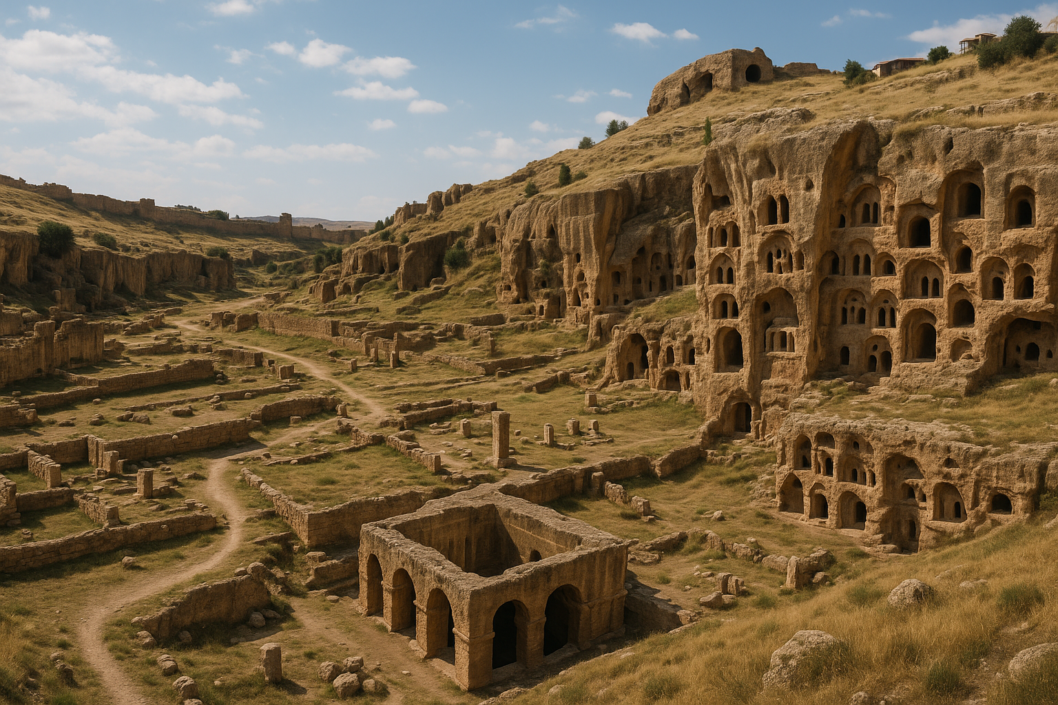
أبرز المعالم
فيما يلي فهرس عملي للمباني التي يصادفها الزائر اليوم، مرتّبًا تقريبًا بحسب ترتيب السير. تبلغ مساحة الهضبة نحو 78 هكتارًا؛ والجولة الكاملة نحو أربعة كيلومترات مع تغيّرات ارتفاع ملموسة عند حواف الجرف.
كاتدرائية أني (سورب أستفاتساتسين، "والدة الإله"، 1001)
بدأها المعمار تردات عام 989 برعاية سمبات الثاني واكتملت عام 1001 في عهد أخيه غاغيك الأول، وهي تحفة العمارة البغراتية وحجر الزاوية في أي زيارة لأني. إنها بازيليكا بقبة على مسقط صليب إغريقي مُدرج في مستطيل — نحو 34 م × 22 م من الخارج — مع أربع دعائم مركّبة ضخمة كانت تحمل قبةً مخروطية شاهقة على طبلة ذات ستة عشر ضلعًا.
انهارت القبة في زلزال 1319 ولم تُعَد، وأُسقطت الطبلة كليًا في زلزال ثانٍ عام 1988. ما بقي هو الصندوق المستطيل الكبير بأذرعته الأربعة سليمة، والفراغ الداخلي الآسر حيث تخلّف غياب القبة فتحةً دائرية من السماء.
ثلاثة عناصر معمارية تستحق الانتباه الخاص.
أولًا، الأقواس المدبّبة. الأقواس الرئيسية التي تنقل الأحمال إلى الدعائم المركزية ليست أقواسًا نصف دائرية رومانسكية بل مدبّبة — قليلًا لكن بوضوح. وتسبق بقرن كامل الشكل ذاته في سان دوني (أربعينيات القرن الثاني عشر). هذا لا يُثبت بذاته أن تردات اخترع القوس القوطي، إذ كان الشكل في استخدام العمارة الساسانية والإسلامية المبكرة وربما وصله عبر نماذج فارسية، لكن الكاتدرائية أقدم ظهور معروف له في مبنى مسيحي على هذا الحجم.
ثانيًا، الدعائم المركّبة. الدعائم الأربع الداخلية ليست أسطوانات مفردة كما في الكنائس الأرمنية المصلّبة المبكرة، بل حزم من ثلاثة أعمدة مُدمجة لكلٍّ منها مع تيجان منحوتة. الأثر البصري يجعل الدعائم تبدو أطول وأخفّ مما هي عليه — حيلة سيُعيد اكتشافها البنّاؤون القوطيون في القرنين الثاني عشر والثالث عشر.
ثالثًا، التعلية الداخلية. للكاتدرائية تعلية حقيقية ذات ثلاثة طوابق — صحن وشرفة (أو بالأحرى قوس أعمى) وطابق إضاءة علوية — بنظام نسَب رأسي طويل يستبق هوس القوطية العليا بالعمودية. كانت نوافذ الإضاءة مُزوَّدةً في الأصل بشاشات من الألباستر الرقيق؛ عُثر على بعض الشظايا في حفريات حديثة.
الواجهة الخارجية مكسوّة بكتل مقطوعة بدقة من الطوف البهيج والوردي، مع أقواس عمياء تلفّ الهيكل الدائري والواجهتين الشمالية والجنوبية. المدخل الغربي يحمل نقشًا بالأرمنية الكلاسيكية يوثّق ريادة تردات وتاريخ الإتمام — أحد المباني القليلة الموقَّعة في القوقاز الوسيط.
كنيسة القديس غريغوريوس لتيغران هونينتس (سورپ كريكور، 1215)
إن كانت الكاتدرائية روعة أني الإنشائية، فكنيسة تيغران هونينتس هي روعتها المصوَّرة. بُنيت عام 1215 في ذروة حقبة الزاكاريين، بتمويل من تاجر ثري اسمه تيغران هونينتس — صورته الواهب بيده مجسّم الكنيسة لا تزال حاضرة في جداريات الرواق. الكنيسة من الناحية المعمارية مصلّب صغير مقبّب، مع طبلة ذات ستة عشر ضلعًا عالية وسقف مخروطي محفوظ تقريبًا بالكامل.
ما يجعل المبنى استثنائيًا هو برنامجه الجداري الداخلي، المرسوم بالأسلوب الكومنيني المشتقّ من القسطنطينية وكبادوكيا المعاصرة. يتضمن الدورة التصويرية حياة القديس غريغوريوس المنيّر (رسول أرمينيا)، والأعياد الليتورجية القياسية (البشارة، الميلاد، المعمودية، التجلّي، الصلب، القيامة، العنصرة)، وقيامة مهيبة للموتى على الجدار الغربي. الألوان — أزرق اللازورد العميق والمُغرة وأحمر الطوب وكثير من الأبيض الهشّ — لا تزال في أماكن كثيرة زاهيةً. النقوش اليونانية والأرمنية تحدّد الشخصيات.
تعرّضت الكنيسة لأضرار جسيمة من الطقس ومن الجنود الذين استخدموا جدرانها هدفًا للتدريب في مطلع القرن العشرين، لكن الجداريات الباقية لا تزال أجمل مجموعة جدارية وسيطة في شرق الأناضول. عملت منظمة صندوق الآثار العالمية ومحافظو وزارة الثقافة التركية على تثبيت المبنى منذ 2011، وتسير عمليات تنظيف الجداريات بصورة متقطعة لكنها مثمرة.
الواجهة الخارجية تحمل شريطًا جميلًا من النقوش الحيوانية على الكورنيش — أسود ونسور وجرافينات وأرانب — وبابًا جنوبيًا مقطوعًا بعناية مع شريط من زخرفة العنب. القوس الأعمى على الطبلة نحيل وأنيق بشكل غير معهود.
كنيسة القديس غريغوريوس للأبوغامرينتس (سورپ كريكور، تسعينيات القرن العاشر)
مبنى صغير لكنه حاسم معماريًا، كُلِّف به في العقد الأخير من القرن العاشر من قِبَل وزير الأسرة الپهلاووني أبوغامير لاستخدامه الخاص. المسقط رباعي القباب — فراغ دائري مركزي محاط بأربعة أشباه دائرية — مُدرج في خارج ذي اثني عشر ضلعًا. الطبلة والسقف المخروطي سليمان؛ الداخل مجرّد من الزينة تقريبًا لكنه يحتفظ بنسبه النبيلة.
تهمية كنيسة الأبوغامرينتس في حفاظها ضمن طلب فخري صغير على تقليد المسقط المركزي الممتدّ عبر زفارتنوتس (القرن السابع) إلى شهداء بيزنطة المبكرة. وهي أيضًا أكثر كنائس أني الصغيرة تصويرًا: تقوم على نتوء شديد الانحدار فوق الوادي، مع إطلالات مباشرة إلى النهر، وعند ساعة الذهب يتوهج الطوف وردةً داكنة دخانية.
كنيسة المخلّص المقدس (سورپ پرغيتش، 1035)
كنيسة المخلّص المقدس أكثر المباني على الهضبة إيلامًا. كانت روتوندة كبيرة ذات قبة وتسعة عشر ضلعًا — شبه دائرية من الخارج — بُنيت عام 1035 برعاية أمير من آل پهلاووني لاستيعاب قطعة أثرية من الصليب الحقيقي جُلبت من القسطنطينية. ظلّت تسعة قرون سليمةً في جوهرها. ثم في ليلة 22-23 يونيو 1957، أصابت صاعقة رعدية القبة المخروطية — المضعَّفة أصلًا بزلزال 1319 — فأسقطت النصف الشرقي من المبنى دفعةً واحدة. النصف الغربي لا يزال قائمًا، مائلًا قليلًا، كمقطع معماري في كتاب مرجعي.
النتيجة واحدة من أكثر الأطلال تصويرًا في تركيا: نصف أسطوانة مثالي من الطوف الوردي يُظهر الجداران الداخلي والخارجي في آنٍ، مع السقف المخروطي محفوظًا على الجانب السليم. أعمال الصيانة منذ 2014 ثبّتت النصف القائم بدعائم فولاذية خفية واستُبدلت حجارة الكورنيش المفقودة من حقل الأنقاض أدناه.
كنيسة سورپ ستيفانوس ("كنيسة الراعي")
كنيسة سداسية صغيرة جدًا على حافة الجرف الشرقية، يُطلق عليها محليًا تشوبان كيليسيسي — "كنيسة الراعي". يعود تاريخها على الأرجح إلى القرن الحادي عشر. المسقط نجمة سداسية الرؤوس مُدرجة في دائرة مع ثلاثة أشباه دائرية داخلية؛ النسب بالغ الإيجاز. فقد المبنى قبته وكثيرًا من جلده الخارجي، لكن الداخل الباقي يحمل أغرب صدى في أني: تصفيقة خفيفة تعود صدىً نظيفًا ذا نغمتين.
اسمها الشعبي مصدره أن الرعاة المحليين استخدموا هذا المبنى ملجأً شتويًا لطارداتهم وحملانهم حتى منتصف القرن العشرين. والاسم الشعبي راسخ منذ ذلك الحين.
مسجد مانوتشهر (1072)
مسجد مانوتشهر هو المسجد الوحيد من حقبة الشدّاديين الباقي على الهضبة الأناضولية كاملًا، وأحد أقدم المباني الدينية الإسلامية التركية القائمة في أي مكان غرب بحر قزوين. أنشأه الأمير مانوتشهر بن أبي الأسوار بُعيد استيلائه على أني عام 1072، وهو يجلس على حافة الجرف فوق الوادي مباشرةً داخل سور القلعة.
المسجد قاعة ذات أعمدة مستطيلة الشكل مع — في الأصل — ستة أعمدة تحمل زوجًا من الأروقة المقبّبة بأقواس مدبّبة. انهار النصف الشرقي في مرحلة ما من القرن السابع عشر؛ النصف الغربي قائم تقريبًا بالكامل مع مئذنته الفارهة ترتفع من الزاوية الشمالية الغربية. تحمل المئذنة نقشًا كوفيًا يتضمن كلمة "بسم الله" محفورةً بالخط السلجوقي المبكر، وهي من أقدم مآذن المساجد القائمة في تركيا.
محراب نصف دائري منقوش بالضفائر والزخرف النخيلي، والأسقف المقبّبة تحفظ شظايا من الزخرفة الملوّنة الهندسية الحمراء والزرقاء. استُخدم المسجد متحفًا في مطلع القرن العشرين من قِبَل نيكولاي مار (انظر أدناه) وكان أول مبنى في أني يُرمَّم وفق مبادئ حديثة، عام 1906.
بوابة الأسد (أرسلان قاپيسي)
المدخل الرئيسي للمدينة — وللموقع الحديث — يمرّ عبر ما يُعرف ببوابة الأسد، وهي مدخل مقوّس ثلاثي في وسط أسوار سمبات. تأخذ اسمها من نقش بارز لأسد خاطف منحوت في الوجه الداخلي للبوابة، يعود على الأرجح إلى القرن الثاني عشر أو الثالث عشر (الأسوار البغراتية نفسها من القرن العاشر لكن النقش إضافة لاحقة). الأسد رمز هرلدي سلجوقي الطراز، مشابه لأسود على خانات القوافل والمدارس السلجوقية المعاصرة؛ ربما أُضيف حين عزّز الأمراء الشدّاديون أو الإدارة المغولية البوابة.
تتجانب البوابة برجان دائريان عظيمان ويتقدّمها جسر حجري فوق الخندق. بوابة ثانية أكثر تفصيلًا غربًا — تُعرف أحيانًا بالبوابة المُربَّعة من زخرفتها الحجرية المطعَّمة — مغلقة أمام الزوار ولا تُبلغ إلا عبر خارج الأسوار.
أسوار سمبات
تمتد الأسوار الشمالية، المسمّاة بسمبات الثاني البغراتوني، نحو 4.5 كم عبر العنق المفتوح للهضبة وتمثّل أروع قطعة معمار عسكري وسيط باقية في منطقة القوقاز والأناضول بأسرها. تتألف من خطّين متوازيين (ستارة خارجية وأخرى داخلية) مع خندق عميق في المقدمة؛ على فترات أربعين مترًا تقريبًا ترتفع أبراج دائرية ومستطيلة فوق الجدران، بعضها قواعد صمّاء وبعضها مُزوَّد بسلالم داخلية وفتحات سهام. ثلاثة أبواب ضخمة تخترق الخط — بوابة الأسد والبوابة المُربَّعة وبوابة قارص — وعدة بوابات خدمية صغيرة.
عُزِّزت الأسوار ثلاث مرات على الأقل بعد سمبات: من قِبَل الملوك البغراتيين في مطلع القرن الحادي عشر، ثم الشدّاديون بعد فتحهم، ثم الزاكاريون في مطلع القرن الثالث عشر. نقوش على أبراج بعينها تحدّد المانحين والبنّائين والتواريخ — أرشيف نادر للرعاية المدنية في العصور الوسطى.
القلعة الداخلية و"القصر السلجوقي"
عند الرأس الجنوبي للهضبة، يرتفع البازلت إلى القلعة الداخلية الصغيرة شديدة الانحدار. هنا قام القصر البغراتي؛ الحكام الشدّاديون والزاكاريون استخدموا الموقع ذاته؛ وبنت الإدارة السلجوقية-الإيلخانية المجمع المستطيل المعروف الآن بـ"القصر السلجوقي"، وهو مبنى ذو فناء من طابقين مع قاعات مقبّبة وبقايا حمام صغير. البناء يمزج البازلت والطوف في نقوش مُربَّعة مميزة للأناضول السلجوقي.
تتجمّع في القلعة كنائس صغيرة عديدة، أكملها كنيسة ذات رواق واحد بسقف برميلي من أواخر الحقبة البغراتية.
قصر التجار (البيت البغراتي)
في النصف الشمالي من المدينة، قرب الكاتدرائية، حُفِرت وأُعيدت جزئيًا أسس دار فناء مستطيل كبير. يعود المبنى إلى أواخر القرن العاشر أو مطلع القرن الحادي عشر ويُعرَّف عرفًا بأنه مقرّ إقامة تاجر بغراتي ثري — "قصر حضري" لا ملكي. يتضمن المسقط فناءً ذا أعمدة وقاعة استقبال شاهقة وحجرات خاصة وجناح خدمات مع صهاريج. وهو من المساكن الحضرية الوسيطة القليلة على هذا الحجم التي حُفِرت في الأناضول.
المسجد الفارسي ("المئذنة المنفردة")
مسجد صغير ثانٍ، يُعرف أحيانًا بـ"مسجد المئذنة" أو المسجد الفارسي، يقوم قرب مركز الموقع، ولم يتبقَّ منه سوى المئذنة متعددة الأضلاع سليمةً. قاعة الصلاة المرتبطة بها اختُزلت إلى أساساتها. يتباين تأريخ البنية بين أواخر الشدّاديين ومطلع الإيلخانيين (نحو 1180-1280)، وتظلّ جهة وقفه غير مؤكدة.
دير العذارى (سورپ هريپسيمه / كوشاقلي كيليسه)
على نتوء ضيق من البازلت يندفع في وادي أخوريان، تُبلَغ بممر وعر وجزئيًا مكسور، تقوم دير العذارى الصغير، المعروف أحيانًا بسورپ هريپسيمه تيمنًا بالقديسة الأرمنية. الكنيسة مبنى سداسي صغير جدًا مقطوع ببراعة، مع طبلة نحيلة وقبعة مخروطية؛ تحيط بها بقايا مجمع رهباني صغير بقيت خطوط مسكنه وطعامه كخطوط أسس.
المشهد استثنائي — الكنيسة تقوم حرفيًا على حافة الجرف مع انحدار عمودي 100 م مباشرةً تحت الهيكل — وهي محليًا من أكثر زوايا أني تصويرًا. الممر ضيق وغير مسوَّر؛ في الريح الشديدة هو خطر حقيقي، ولافتة عند رأس الممر تحذر الزوار بالمضي على مسؤوليتهم.
الجسر عبر نهر أخوريان
أسفل مسجد مانوتشهر على قاع الوادي، كان الجسر الوسيط الكبير لأني يحمل الطريق الجنوبي عبر الأخوريان إلى إقليم باغاران. ركيزتان ضخمتان من البازلت باقيتان: إحداهما على الضفة التركية والأخرى على الأرمنية، مع القناطر المتوسطة المتساقطة منذ أمد بعيد. بُني الجسر على الأرجح في أواخر القرن العاشر وجُدِّد في الحقبة السلجوقية ومجددًا في القرن الثالث عشر. تظهر الصور الجوية من خمسينيات القرن العشرين قنطرةً واحدة قائمة على الجانب الأرمني؛ أسقطها زلزال في الستينيات.
الركيزتان تبدوان من عدة نقاط على حافة الوادي، لكن الممر إلى النهر مغلق.
الكنائس المفقودة وغير المعرَّفة
قائمة عمل بأبرز الكنائس المفقودة أو غير المعرَّفة في أني — المعروفة من النقوش أو الإشارات التأريخية أو مسقطات الأسس التي يكاد يصعب تتبّعها الآن — تشمل:
- كنيسة سورپ بوغوس (القديس بولس) وسورپ پيتروس (القديس پطروس)، تذكرهما أريستاكيس لاستيفيرتسي دون توضيح موقع مؤكد.
- كنيسة الرسل المقدسين، حُفِرت جزئيًا في التسعينيات وكشفت عن تيجان تُظهر بعض أقدم تصاميم الدعامات المركّبة في العمارة الأرمنية.
- كنيسة القديس غريغوريوس المنيّر الدائرية (المعروفة بالغاغيكاشن)، بناها غاغيك الأول في مطلع الألفية نموذجًا لزفارتنوتس؛ لا يزال مسقطها المستدير الدائري مرئيًا بأبعاد لا تزال لافتة.
- كنيسة صغيرة من الحقبة الجورجية قرب كنيسة تيغران هونينتس، حُدِّدت بنقش جورجي عُثر عليه عام 1998.
- كنيستان إضافيتان ذواتا رواق واحد على القلعة، غير محدَّدتَي التاريخ.
عدد الكنائس الموثَّقة بثقة في أني — بالآثار أو النقش أو السجلّ التاريخي — يبلغ نحو أربعين. "الألف كنيسة وكنيسة" المذكورة في التراث الشعري مبالغة بالطبع.
مسار المشي المقترح
للزوار المفضّلين التفكير بالطرق لا الفهارس، يوصى بالتسلسل الآتي عبر المعالم الرئيسية:
- الدخول من بوابة الأسد؛ التوقف لقراءة نقوش الأبراج والنظر إلى نقش الأسد.
- المشي جنوبًا عبر الممر الشرقي إلى الكاتدرائية؛ قضاء عشرين دقيقة في الداخل.
- الاستمرار جنوبًا شرقًا إلى كنيسة المخلّص المقدس؛ مشاهدة نصف الانهيار وشظايا الكورنيش أدناه.
- المشي شرقًا إلى كنيسة تيغران هونينتس؛ قضاء عشرين دقيقة على الأقل مع الجداريات.
- النزول بالممر إلى كنيسة الراعي على حافة الجرف؛ اختبار الصدى.
- الاستمرار جنوبًا على طول الجرف إلى دير العذارى؛ الحذر على الممر الضيق.
- الصعود والسير على طريق الجرف الغربي إلى مسجد مانوتشهر.
- داخل المسجد، صعود المئذنة إن كانت مفتوحة وآمنة؛ وإلا الإعجاب بها من أسفل.
- الاستمرار جنوبًا إلى القلعة الداخلية والقصر السلجوقي.
- العودة شمالًا عبر النصف الغربي من الهضبة، مع التوقف عند مسقط الغاغيكاشن الدائري والمسجد الفارسي وقصر التجار وكنيسة الأبوغامرينتس.
- الخروج من بوابة الأسد.
مسافة المشي الإجمالية: نحو 4.2 كم. الوقت الإجمالي مع توقفات معقولة: أربع إلى خمس ساعات.
الأهمية المعمارية
تحتلّ أني مكانةً بالغة الأثر في تأريخية العمارة الوسيطة. فلمدينة أرمنية-قوقازية هاجمها السلاجقة وحكمها الأكراد والجورجيون وأمحاها زلزال، أفرزت حجمًا استثنائيًا من النقاش حول مسائل تبدو في مبدأها شأنًا من شؤون العصور الوسطى الأوروبية الغربية: من اخترع القوس المدبّب؟ متى ظهر الارتفاع القوطي لأول مرة في كنيسة مسيحية؟ هل حمل الصليبيون هذه الأفكار غربًا إلى فرنسا، أم أن أوجه الشبه محض تزامن؟
سبب بروز أني يعود في معظمه إلى شخصية تردات.
تردات المعمار
تردات (أحيانًا تيردات أو تيريداتيس) هو المعمار الأرمني الوسيط الوحيد الذي يُنسب إليه بثقة اثنان من أهم مباني قرنه. وُلد على الأرجح نحو عام 940، تدرّب في تقاليد البناء الأرمنية العليا — التي هي بدورها وارثة التقاطع الساساني-البيزنطي في القرن السابع — وخدم أولًا الملوك البغراتيين في أني ثم، بعد زلزال 989، الإمبراطور البيزنطي باسيل الثاني في القسطنطينية.
مأثرة القسطنطينية موثَّقة لدى المؤرخ ستيفانوس تارونيتسي في القرن الحادي عشر، الذي يروي أنه حين أسقط زلزال 25 أكتوبر 989 النصف الغربي من قبة آيا صوفيا "أرسل الإمبراطور في طلب تردات معمار الملك الأرمني، فجاء وأعاد بناءها بمهارة فائقة." هذه إحدى الحالات النادرة جدًا في العالم الوسيط التي استقدم فيها إمبراطور بيزنطي صراحةً حرفيًا من غير البيزنطيين للتعامل مع أزمة إنشائية في كاتدرائيته الإمبراطورية.
تكوّن إصلاح تردات للقبة لا من إعادة بنائها من الصفر بل من تعزيز الجبهات المثلثية الباقية واستبدال الأقواس المكسورة والضلوع العمودية وإنشاء نصف قبة غربية جديدة ذات ميل أكثر انحدارًا. تُحدّد التحليلات الإنشائية الحديثة لآيا صوفيا هذه العناصر اللاحقة على عام 989 بوصفها من أقوى عناصر المبنى؛ وقد صمدت في كل زلزال لاحق دون إخفاق.
عند عودته إلى أني، أُسندت إليه مأثرة الكاتدرائية، ثم انتقل نموذجه الكاتدرائي إلى كنيستَين ملكيتَين لاحقتَين و— بشكل غير مباشر — إلى جيل من المباني الإقليمية عبر أرمينيا القوقازية وجورجيا.
مسألة القوس المدبّب
القوس المدبّب هو أكثر سمات العمارة القوطية تميزًا. أقدم استخدام موثَّق له في مبنى مسيحي على مستوى الكاتدرائية في أوروبا الغربية هو في مقصورة الأب سوجيه في سان دوني (مكرَّسة 1144). الأقواس المدبّبة في كاتدرائية أني، في المقابل، ترجع إلى عام 1001 — قبل قرن ونصف تقريبًا.
لا يُثبت هذا بذاته أي "تأثير قوطي" من أي نوع. كان القوس المدبّب في استخدام بلاد فارس الساسانية من القرن الرابع على الأقل، وفي العمارة الإسلامية المبكرة من القرن السابع، وفي مباني الفاطميين المصريين كمسجد الحاكم (نحو 1000) وفي الكنائس الكيليكية-السورية في القرن الحادي عشر. إنه شكل إنشائي متاح لأي ثقافة تبني قباباً حجرية، وقد يعكس ظهوره في كاتدرائية تردات تأثيرًا فارسيًا مباشرًا لا اختراعًا مستقلًا.
ما يجعل أني مهمة في قصة القوطية هو المزيج من القوس المدبّب مع الدعائم المركّبة والتقبيب الضلعي ونظام النسب الرأسي الصارم والتعلية الداخلية الثلاثية الطوابق. هذه الحزمة — المجموعة التي تجعل المبنى قوطيًا تحديدًا لا مجرد مقوّس القباب — موجودة بشكل شبه مكتمل في كاتدرائية أني عام 1001 وفي سان دوني عام 1144 وفي سانس نحو 1140.
مسألة ما إذا كانت الحزمة انتقلت من الأناضول إلى فرنسا مع الصليبيين العائدين، أو مع البنّائين الأرمن والسوريين العاملين في مملكة القدس، أو مع المستعمرات الأرمنية المنتشرة في جنوب إيطاليا وصقلية — أو إذا كان التوازي محض تزامن في الاختراع المستقل — أفرزت أدبًا أكاديميًا واسعًا، بدأ بكتاب يوزيف ستريغوفسكي المثير للجدل عام 1918 عمارة الأرمن وأوروبا. بالغ ستريغوفسكي نفسه في طرحه بإفراط مع نبرة قومية واضحة؛ واتسم الباحثون اللاحقون بمزيد من التحفظ. بيد أن الأولوية الزمنية لأني لم تعد محلّ خلاف جدّي، والسؤال الأوسع عن الانتقال من الشرق إلى الغرب لا يزال مفتوحًا.
المدرسة البغراتية
بعيدًا عن مسألة التأثير القوطي، تهمّ أني لأنها تمثّل ذروة مدرسة إقليمية متماسكة من العمارة الكنسية الوسيطة. تتميّز المدرسة البغراتية بـ:
- المساقط المركزية، ولا سيما الصليب المحفور في المربع والرباعي القباب والروتوندة المضلّعة.
- طبلات مرتفعة ذات ستة عشر ضلعًا وسقوف مخروطية حادة الزاوية مغطاة بالطوف المقطوع بدقة.
- أقواس عمياء تلفّ الخارج، أحيانًا بأعمدة مزدوجة مدمجة.
- نحت بارز يتركّز عند المداخل والطبلات والكراسي، بزخارف العنب والحيوان والهندسة.
- تقنية بناء تجمع وجهًا خارجيًا من الطوف المصهور بدقة مع قلب من الحجارة المهروسة، مما يتيح تفاصيل خارجية أنيقة دون وزن إنشائي مفرط.
- ميل إلى النوافذ الضيقة الشقّية، المزدوجة أحيانًا والمدبّبة قليلًا، التي تمنح الداخل ضوءًا ذهبيًا ناعمًا.
أنتجت هذه المدرسة، بأني مركزًا لها، كنائس في مارماشين وهوروموس وختسكونك وتيكور، وأثّرت في العمل الجورجي المعاصر في ساپارا وپيتاريتي وغيرهما.
الهندسة الإنشائية: دور الملاط
نقطة أقل بريقًا لكن بالغة الأهمية تقنيًا: ملاط الجير البغراتي هو من أقوى ملاطات العصور الوسطى المعروفة في أي مكان في العالم المتوسطي والقوقازي. كشفت التحليلات الكيميائية الحديثة (المنشورة في تقارير الصيانة بين 2014 و2019) عن وصفة تستخدم جيرًا مطفأ عالي الجودة وطوبًا أو بلاطًا مكسورًا إضافةً بوزوليّةً وكميات صغيرة من مواد رابطة عضوية — يُرجَّح بياض البيض أو البروتين الحيواني. وقت الشدّ طويل لكن قوة الضغط النهائية استثنائية وتضاهي الملاطات الهيدروليكية من مطلع العصر الحديث.
هذا الملاط هو ما يُماسك أني. الكتل الطوفية المقطوعة ما كانت وحدها لتصمد لألفية من دورات التجمد والذوبان على هضبة قارص؛ الملاط هو ما يمنح الجدران مرونة الشدّ. حرصت الصيانة الحديثة على مطابقة الوصفة الأصلية في أعمال إعادة التأليف بدلًا من استخدام إسمنت حديث سيتصرف بشكل مختلف كليًا ويُسبّب شقوق إجهاد.
نموذج الرعاية
سمة مميزة للعمارة البغراتية هي الدور المحوري للرعاية العلمانية المسمّاة. معظم الكنائس الكبرى في أني لم تكن مؤسّسات ملكية بالمعنى الدقيق بل طلبات من أسر أرستقراطية أو تجار أثرياء. موّل كنيسة الأبوغامرينتس وزير الأسرة الپهلاووني أبوغامير؛ كنيسة تيغران هونينتس كانت هدية تاجر؛ المخلّص المقدس طلب أسري لآل پهلاووني. الأسرة الملكية قدّمت الكاتدرائية والأسوار؛ النخبة الحضرية قدّمت كل شيء سواها.
بالمصطلح الأوروبي الوسيط، هذا نموذج "برجوازي" لافت في الرعاية الدينية، يستبق الكنائس الممولة من التجار في فلاندرز وإيطاليا في أواخر العصر الوسيط. يعكس على الأرجح الطبقة التجارية الثرية والواثقة سياسيًا في مدينة طريق حرير من القرن الحادي عشر. أني كانت مكانًا يستطيع فيه رجل ثري واحد أن يبني كنيسةً كبرى ويضع صورته في الرواق.
النحت البارز
أني هي أيضًا أغنى مستودع منفرد للنحت الأرمني الوسيط المنزَّل. تحمل كراسي كنيسة تيغران هونينتس إفريزًا شهيرًا من الحيوانات — نسور وجرافينات وأسود وأرانب وأيائل — يجمع الأيقونوغرافيا الساسانية والحرفية البيزنطية. الواجهة الخارجية للكاتدرائية مزيّنة بأقواس عمياء مزدوجة ونقش مريلي بارز لوالدة الإله (متآكل كثيرًا اليوم) فوق الباب الجنوبي. كانت طبلة المخلّص المقدس تحمل دورة كاملة من الصلبان المنحوتة على محيطها؛ كثير منها نجا من انهيار 1957 ويرقد الآن في حقل الأنقاض أدناه.
مجموعة متحف صغيرة في قارص — وأخرى أكثر حجمًا في سانت پطرسبورغ، مجموعة مار — تحفظ الشظايا القابلة للنقل.
الخزين الأيقونوغرافي
يستحق التفصيل في خزين الأيقونوغرافيا للنحت البغراتي والزاكاري في أني، إذ يمثّل نظامًا أسلوبيًا متماسكًا في القوقاز الوسيط.
الدوافع الشائعة تشمل:
- أوراق الكروم — تلفّ المداخل والكراسي مع عناقيد العنب والأوراق والمجاريات منحوتةً في بارز خفيف. الزخرفة العنبية تحمل رمزية أفخارستية مسيحية واضحة لكنها تعمل أيضًا عرضًا لبراعة تقنية نحت الحجر.
- الأسود — هرلدية خاطفة أو راجفة، غالبًا كحراسة للأبواب. بوابة الأسد في أني تمنح المدخل اسمه الحديث؛ تظهر الأسود أيضًا على كورنيش كنيسة تيغران هونينتس.
- النسور — أحادية أو مزدوجة الرأس، رمزًا للسلطة الملكية وبعد القرن الثاني عشر للأيديولوجيا الإمبراطورية البيزنطية والسلجوقية. كورنيش تيغران هونينتس يتضمن نسرًا رائعًا.
- الجرافينات — مخلوقات مزدوجة بجسم أسد ورأس نسر، غالبًا يواجه بعضها بعضًا عبر محور مركزي. شائعة في الفن الفارسي الساساني وموروثة في الخزين القوقازي.
- الأرانب — أحيانًا في لحظة يخطفها مفترس، وأحيانًا تجري ببساطة. قد تحمل أيقونوغرافيا الصيد معانيَ أسخاتولوجية.
- الأيائل والغزلان — حيوانات سلمية، غالبًا عند جدول أو بركة، رمزًا للروح التي تشتاق إلى النعمة (بعد المزمور 42).
- الطواويس — رموز الخلود، غالبًا على جانبَي صليب أو شجرة مركزية.
- الرمان والزنبق — دوافع الفاكهة والزهور ذات أدوار ليتورجية وزخرفية مختلطة.
- الصلبان — بعشرات الأنواع: صلبان يونانية بسيطة، وتصاميم الخاتشكار الأرمنية المتفصّلة، وصلبان موكبية، وصلبان على أعواد، وصلبان مع شرفات.
- والدة الإله — غالبًا فوق الباب الجنوبي للكنائس الكبرى، مع الطفل المسيح أو بدونه.
- صور الواهبين — أشهرها صورة تيغران هونينتس حاملًا مجسّم كنيسته. هذا الدافع يستبق بقرنين الأسلوب ذاته في الأيقونات الإيطالية من القرن الرابع عشر.
النحت شبه كامل في البارز الخفيف؛ البارز العميق نادر. الطوف متسامح لكنه لا يحفظ التفاصيل الحادة عبر القرون؛ كثير من الأنحوت الأكثر تعرّضًا تآكل كثيرًا. أفضل الأنحوت الباقية في الداخل أو على الطبلات العلوية المحمية.
الحجر والملاط ومسألة النجاة الزلزالية
سؤال مشروع، بالنظر إلى تاريخ زلزال 1319 الكارثي للمدينة، هو كيف نجا أي من هذه المباني أصلًا. الجواب يكمن في تركيبة المواد والأساليب التي طوّرها البنّاؤون البغراتيون خلال القرنين العاشر والحادي عشر.
التقنية الأساسية جدار ذو جلدين: وجه خارجي من الطوف المصهور بدقة، ووجه داخلي أيضًا من الطوف المقطوع، وقلب من الحجارة المهروسة في ملاط جير قوي مخلوط بالطوب المكسور (يشبه ما يُعرف بـأوپوس كايمينتيتيوم بالقياس مع الوصفة الرومانية، غير أن النسخة البغراتية تستخدم حصبًا مختلفة). الوجه الخارجي لا يحمل أي ثقل بذاته؛ القلب يحمل ثقل الجدار؛ الجلدان يعملان كقوالب. النتيجة جدار ثقيل لكن غير هشّ — قادر على الانحناء الطفيف في الحدث الزلزالي دون أن يتفتت.
القباب هي نقطة الضعف. الحلّ البغراتي كان بناء قشرة القبة رقيقةً نسبيًا (نحو 60 سم في الكاتدرائية) لكن إثقال الطبلة بزخارف الأقواس العمياء الضخمة التي تحوّل الطبلة العلوية فعليًا إلى حلقة عارضة ثقيلة. نجح الأسلوب في الكاتدرائية 318 عامًا، حتى تجاوز عام 1319 تحمّل التصميم. كنيسة تيغران هونينتس، الأصغر والأحدث، نجت من 1319 سليمةً ولا تزال قائمة اليوم.
النقوش كأرشيف
تنضمّ مجموعة مستقلة من قضايا الصيانة إلى النقوش. وقّع الواهبون البغراتيون والشدّاديون والزاكاريون والإيلخانيون أعمالهم في الحجر، والنتيجة من أكثف الأرشيفات الكتابية في القوقاز الوسيط في أي مكان. سجّل فريق مار نحو 5,000 نقش فردي؛ وأضافت حملات تشوروهلو عدة مئات أخرى من السياقات التي أُفرجت منذ 2005.
تتراوح النقوش بين نصوص التأسيس الضخمة على واجهات الكنائس وخربشات خدشها حجاج عابرون على أعمدة جانبية. تتضمن إعلانات ملكية وتكريسات رهبانية وتبرعات تجارية وإعفاءات ضريبية — وفي حالة لوحة مشهورة العبارات قرب بوابة الأسد — لعنةً على كل من يُلحق أذى بالسور، محرَّرةً بأسلوب البلاغة الأرمنية من القرن الخامس لكن مؤرَّخةً لمطلع القرن الحادي عشر. لم يُنشر قطّ مجموعة كاملة؛ ونشر النقوش لا يزال المهمة الأكبر غير المنجزة في الدراسات الأنيّة.
الضوء والموسم والصمت
أخيرًا، كلمة عن ما هو ربما البُعد الأقل تقديرًا في أني — ضوؤها وصمتها وطقسها. الهضبة مكشوفة؛ الوادي أدناه مصدّ صوتي رائع للريح؛ الهواء جاف وصافٍ. عند الظهيرة في الصيف الشمس قاسية والحجارة ساخنة. عند الفجر الضوء فضّي والوادي أدناه يحتضن حزامًا سميكًا من الضباب لا يتقشّع حتى الثامنة. عند الغروب تتحوّل الهضبة بأسرها إلى وردي عميق، وتتوهج القبة المخروطية لكنيسة تيغران هونينتس، ويسقط ظلّ طويل عبر السوق من مئذنة مانوتشهر.
هذا أيضًا من أكثر المواقع الأثرية هدوءًا في تركيا. خارج ذروة أغسطس، كثافة الزوار منخفضة بما يتيح لك أن تقف وحيدًا في الكاتدرائية خمس عشرة دقيقة دون أن ترى إنسانًا. الريح تأخذ كل صوت بعيدًا عبر الوادي. الأثر، لدى الزائر المتفاعل، أقرب إلى التجربة الدينية منه إلى السياحة.
مدينة متعددة الثقافات
تُقدَّم أني أحيانًا في نشرات السياحة الحديثة بوصفها "مدينة أرمنية" وأحيانًا أخرى "مدينة تركية"، تبعًا للمزاج السياسي للمطبوع. كلا التوصيفين جزئي. تُرسم في الأدلة التاريخية — السجلات والنقوش والمسكوكات والآثار — صورة مدينة حدودية متعددة الأديان والأعراق تحقيقًا، كانت المسيحية الأرمنية فيها مهيمنة بالفعل لكنها لم تكن قط وحدها.
النواة الأرمنية
كان المجتمع الأكثر عددًا وثقافةً في أني طوال تاريخها مسيحيًا أرمنيًا. الأسرة الملكية البغراتية أرمنية؛ جاثليق الكنيسة الرسولية الأرمنية أقام هنا في حقبتين (القرن الحادي عشر ثم باختصار تحت الزاكاريين)؛ الكنائس الكبرى أرمنية؛ المنتوج الأدبي للمدينة — بما فيه تاريخ أريستاكيس لاستيفيرتسي وتاريخ الأرمن لستيفانوس أسوغيك — بالأرمنية الكلاسيكية.
ظلّت الأرمنية لغة السوق والرعية تحت كل الأنظمة اللاحقة. حتى في ظل حكم الشدّاديين تحمل العملات المسكوكة في أني نقوشًا أرمنية إلى جانب العربية، ويُبلَّغ في روايات المسافرين المعاصرين عن الأرمنية بوصفها أكثر اللغات سماعًا في الشوارع.
الحضور الإسلامي
مجتمع مسلم موثَّق في أني منذ لحظة الفتح السلجوقي عام 1064، وربما وُجد قبله بشكل أصغر في صفوف التجار الفرس والعرب. أحضرت إمارة الشدّاديين (1072-1199) طبقةً عسكريةً وإداريةً كردية-تركية كبيرة، وعدة مساجد: مسجد مانوتشهر (1072) والمسجد الفارسي (القرن الثاني عشر) ومسجد آخر على الأقل في القلعة معروف من بقايا أساساته فحسب.
شارك المجتمع المسلم أسواق المدينة ومحاكمها مع المجتمع المسيحي. لدينا عدة حالات موثَّقة من الزواج المختلط ومشاريع تجارية مشتركة ونزاعات قانونية ذهبت أمام محاكم مسيحية-إسلامية مشتركة. بُني مسجد مانوتشهر على حافة الوادي على بُعد أقل من 200 متر من الكاتدرائية؛ التجاور البصري للقبة والمئذنة كان بيانًا إماريًا متعمدًا للتعايش.
الأرثوذكسية الجورجية
تحت الزاكاريين (1199-1239) تأسّس مجتمع أرثوذكسي جورجي في أني مستقل عن الأغلبية الرسولية الأرمنية. كان الأخوان الزاكاريان نفساهما أرمنيَّي الأصل لكنهما متوثّقان بالتاج الجورجي والكنيسة الأرثوذكسية الجورجية (الخلقيدونية في مقابل التقليد الأرمني الميافيزيتي). شُيّدت أو أُعيدت كنائس صغيرة عديدة لاستخدام جورجي في تلك الحقبة؛ ونقش جورجي اللغة على القلعة يوثّق تأسيس إحداها عام 1213.
التجار الفرس والزرادشتيون
كان التجار الفرس المسلمون حضورًا مستمرًا من حقبة الشدّاديين فصاعدًا، أحيانًا مستوطنين وأحيانًا موسميين. ثمة أيضًا أدلة، من إشارات السجلات ومن مبنى واحد محفور قرب الأسوار الجنوبية، على مجتمع زرادشتي صغير — عابدو النار الفرس الذين كان دورهم في شبكة التجارة الحضرية كافيًا لاستحقاق دار عبادة. يحفظ المبنى المحفور قاعدة مذبح نار ناقصة وأسس مجمع محاط صغير.
التجار اليهود
ربع يهودي مذكور في سجلَّين أرمنيَّين من القرن الثاني عشر ومضمَّن في عدة عقود تجارية يهودية-أرمنية ثنائية اللغة باقية من أرشيف المدينة (موجودة الآن في يريفان والقدس). لم يُحدَّد الربع بأمان على أرض الواقع، لكن يُرجَّح أنه قام قرب الأسوار الشمالية قرب محطة القوافل الرئيسية.
الحضور اليهودي في القوقاز الوسيط موثَّق من القرن الثامن على الأقل، وكان ملف أني التجاري عاملًا طبيعيًا للتجار اليهود الذين يشغّلون الطرق بين القسطنطينية وتبريز ودول الخزر الخلَف على أسفل الفولغا. فُرضت أنه كان ثمة كنيس صغير لكنه لم يُعثر عليه؛ قد يُحدّده المسح الجيوفيزيائي في المستقبل.
المسيحية المعارضة والمجتمعات البولسانية
تعقيد ديني آخر في المدينة الوسيطة هو الوجود الموثَّق للمجتمعات المسيحية المعارضة — أبرزها البولسانيون، طائفة ثنائية ذات قواعد راسخة في مرتفعات شرق الأناضول والأراضي الأرمنية من القرن الثامن. اضطُهد البولسانيون مرارًا من قِبَل السلطات البيزنطية والهيرارشية الرسولية الأرمنية السائدة، وبدت أني — بتنوع ولاياتها — توفّر تسامحًا نسبيًا.
تشير إشارات السجلات إلى مجتمع بولساني صغير لكن راسخ في أني عبر القرنين الحادي عشر والثاني عشر. بعد الضمّ البيزنطي عام 1045 تعرّض للاضطهاد مؤقتًا؛ في ظل الشدّاديين كان أكثر حرية؛ في عهد الزاكاريين حاولت الهيرارشية الرسولية الأرمنية إعادة امتصاصه أو قمعه. لم يُحدَّد أي معلم بولساني بعينه على أرض الواقع.
اللغات في الشوارع
تمرين مفيد أن تتساءل عن اللغات التي كان يسمعها زائر عابر في شوارع أني عام 1200 مثلًا. الجواب أكثر تعدديةً مما يُفترض أحيانًا:
- الأرمنية الكلاسيكية والأرمنية الوسيطة — اللغة المنطوقة المهيمنة، يستخدمها أغلب السكان في الأسواق والإكليروس والطبقة التجارية.
- الفارسية — يستخدمها التجار الزوار من تبريز وخراسان وكتّاب إدارة الشدّاديين (ثم الزاكاريين) والمقيمون الزرادشتيون والفارسيون-المسلمون.
- العربية — لغة الوثائق القانونية والشؤون الدينية في المجتمع المسلم والمراسلات الإدارية الطارئة.
- الجورجية — لغة البلاط الزاكاري والنخبة العسكرية ورجال الدين الأرثوذكس الجورجيين المقيمين ومجتمعات رهبانية بعينها.
- اليونانية — لغة المبعوثين البيزنطيين الزائرين وبعض تجار طرابزون ومجتمع مسيحي خلقيدوني صغير باقٍ.
- العبرية — لغة الحياة الدينية في الربع اليهودي.
- اللهجات الكردية والتركية — شائعة بصورة متزايدة من أواخر القرن الثاني عشر فصاعدًا، ولا سيما في صفوف العسكر والمستوطنين التركمان الأناضوليين.
هذه بالمعنى اللغوي مدينة أقرب إلى طليطلة الوسيطة أو باليرمو منها إلى معظم المدن الأناضولية أو البيزنطية المعاصرة. لم تكن التعددية اللغوية استثناءً في أني؛ كانت الشرط الاشتغالي.
كونية طريق الحرير
السبب العميق لكل هذا التعدد الديني والعرقي كان بالطبع طريق الحرير. كانت أني المحطة الجمركية الأناضولية الرئيسية على الفرع الشمالي من الطريق، ذاك الذي يعبر القوقاز من تبريز إلى طرابزون، وكان رخاء المدينة متوقفًا على استعداد التجار الفرس والعرب والإغريق والإيطاليين للصعود إلى هضبة قارص. استوعبتهم المدينة — بخانات القوافل قرب مسجد مانوتشهر ونظام المستودعات المقيّدة ومحكمة تجارية متعددة الأديان.
انحدار أني بعد 1239 بهذا المعنى لا ينفصل عن انحدار طريق الحرير الشمالي، حين حوّل السلام المغولي التجارة بعيد المدى نحو طرق جنوبية عبر العراق والشام.
ما كان يُتداوَل
تشمل قائمة عمل بالبضائع الموثَّقة في أرشيفات أني التجارية من القرنَين الحادي عشر والثاني عشر: الحرير الخام من فارس وآسيا الوسطى؛ المنسوجات الحريرية النهائية من القسطنطينية والموصل؛ التوابل (الفلفل والهيل والمستكة) من جنوب الهند عبر فارس؛ اللازورد والفيروز من خراسان؛ الخيول من السهوب؛ الفراء من حوض الفولغا؛ النحاس من أرزنجان؛ الفضة من مناجم القوقاز؛ الملح من بحيرة أورمية؛ الشمع والعسل من المرتفعات الأرمنية؛ والخمر البيزنطية. تشير حسابات السوق أيضًا إلى منتجات أني المحلية — الصوف والجلد واللحوم المُعالجة والأجبان القوقازية الشهيرة — المُصدَّرة إلى طرابزون وحلب.
وعائدات جمارك المدينة في السنوات الجيدة يُقدِّرها المؤرخ أريستاكيس لاستيفيرتسي بـ"مئة ألف دينار"، رقم ينبغي معاملته بلغة الخطاب لكنه يشير إلى أن أني كانت مركزًا جادًا لتحصيل الإيرادات لا مجرد سوق إقليمية.
الأسواق على أرض الواقع
أوضحت حفريات مار والحملات الأخيرة لتشوروهلو قطاعات كبيرة من حي السوق الوسيط، الذي احتلّ العمود الفقري المركزي للمدينة بين الكاتدرائية ومسجد مانوتشهر. المسقط الناجم هو شارع سوق طويل ضيق مع حوانيت مقبّبة تنفتح على الجانبين، وعدة شوارع متقاطعة مغطاة (على الأرجح بأسقف خشبية لم تنجُ)، وتجمعات من خانات القوافل — فنادق بفناء مع إسطبلات في الطابق الأرضي وغرف فوقها — مركّزة قرب البوابة الجنوبية.
ثلاثة خانات قوافل على الأقل حُدِّدت بثقة، أكبرها بمقاس نحو 40 م × 25 م. خطوط الأسس لعدد أكثر مرئية في المسوحات الجيوفيزيائية. أسلوب البناء في خانات القوافل يجمع التقنيات البغراتية-الأرمنية مع الجدران المخططة المتناوبة بين البازلت والطوف المميزة للأناضول السلجوقي.
المسكوكات وإمداد النقود
السجل النميزماتي في أني استثنائي أيضًا. الدراهم الفضية البغراتية من أواخر القرن العاشر ومطلع الحادي عشر المسكوكة في دار سكّ أني تداولت حتى القرم وأعالي الفولغا. العملات النحاسية والفضية الشدّادية من أواخر القرن الحادي عشر والثاني عشر تحمل أساطير عربية لكن أسماءً أرمنية ورموزًا مسيحية أحيانًا، عاكسةً الإدارة ثنائية اللغة. عملات الحقبة الجورجية أندر في الموقع ذاته لكنها موثَّقة جيدًا في مكتشفات إقليمية. العملات الإيلخانية شائعة.
لم يُحدَّد بأمان دار السكّ في الآثار، لكن مبنىً صغيرًا ذو موقد ضخم بصورة غير عادية حُفِر قرب القلعة في السبعينيات اقترحه بعض الباحثين موقعًا محتملًا لدار السكّ.
الأعمال الأثرية
الفهم الأثري الحديث لأني هو نتاج نحو 180 عامًا من البحث أُجري في ظل خمسة أنظمة سياسية متعاقبة (عثماني، روسي، جمهورية تركية متأثرة بالسوفيتية، تركية حديثة، والآن دولية مشتركة). ترك كل نظام طبقةً من التفسير، وتجربة الزائر الحديث للموقع مشكَّلة بكلٍّ منها.
شارل تكسييه، أربعينيات القرن التاسع عشر
أول وصف أكاديمي حديث جدّي لأني يأتي من المعمار والأثري الفرنسي شارل تكسييه الذي زار الموقع عام 1842 في إطار رحلات استطلاعية كبرى أسفرت عن مجلّده وصف آسيا الصغرى (3 مجلدات، 1839-1849). أنتج تكسييه مخططًا مقيسًا للكاتدرائية وعدة مقاطع للأسوار ورسمًا منظوريًا جميلًا للقلعة، كلها محفورة كألواح في مجلداته. عمله أول قطعة علمية تعامل مع أني بوصفها عمارةً لا أطلالًا، وقياساته تظلّ دقيقةً إجمالًا.
يتضمن تقرير تكسييه أيضًا أول محاولة للتحليل المقارن. لاحظ الأقواس المدبّبة في الكاتدرائية، استخلص التوازي الجليّ مع القوطية، وتكهّن بحذر حول الانتقال. شحذ الفرضيةَ كتّابٌ لاحقون، لكن الفضل في طرح السؤال يعود إليه.
نيكولاي مار والحملات الروسية، 1892-1917
التحوّل الحاسم لأني من أطلال بانورامية إلى موقع أثري عامل جاء مع الحملات الروسية الطويلة لنيكولاي ياكوفليفيتش مار (1865-1934)، المتخصص في شؤون القوقاز ذي الأصل الجورجي-الاسكتلندي من جامعة سانت پطرسبورغ. زار مار أني لأول مرة عام 1892 وأجرى حملات حفر كاملة كل صيف تقريبًا من 1904 إلى 1917، مع انبعاث مختصر في 1921-1923.
أسفرت حملات مار عن:
- مسح طوبوغرافي كامل للهضبة.
- حفر الكاتدرائية وكنيسة تيغران هونينتس والكنيسة الدائرية غاغيكاشن ومسجد مانوتشهر (الأول الذي جُلّي ورُمِّم) والقصر السلجوقي وأجزاء كبيرة من الأسواق.
- اكتشاف أكثر من 5,000 نقش — أرمنية وعربية وجورجية وفارسية ويونانية — معظمها لا يزال غير منشور.
- متحف للموقع موجود في مسجد مانوتشهر مع مجموعة من الشظايا المعمارية والفخاريات والمسكوكات والمكتشفات الصغيرة.
- دار حفر عملة في القرية، درّبت فيها أجيال من علماء الدراسات القوقازية.
قُسِّمت مكتشفات مار بين متحف في أني ذاتها والهيرميتاج ومتحف آسيا في سانت پطرسبورغ. كثير من الشظايا المعمارية وأنواع الفخاريات والحجارة المنقوشة في الهيرميتاج اليوم مصدرها هذه الحملات؛ الألواح المسمارية والشظايا الأورارتية موجودة هناك أيضًا. دُمِّر متحف الموقع إلى حدٍّ بعيد في قتال 1918-1920 في المنطقة، والأشياء الناجية منه موزَّعة بين يريفان وقارص وسانت پطرسبورغ.
أنهت الثورة الروسية والانهيار اللاحق للنفوذ الروسي في شرق الأناضول حملات مار. وضع معاهدة قارص عام 1921 التي رسّخت الحدود على نهر الأخوريان أني داخل تركيا بإحكام وأغلق الموقع فعليًا أمام الأثريين الروس والأرمن لبقية القرن العشرين.
الجمهورية التركية، الخمسينيات – الثمانينيات
بدأ العمل الأثري التركي المستدام في أني في أواخر خمسينيات القرن العشرين فحسب، حين بدأت مديرية الآثار العامة في إيفاد فرق سنوية صغيرة. الشخصية التركية المبكرة الرئيسية كانت كمال بلكان الذي أجرى حملات مختصرة في مطلع الستينيات. من 1965 فصاعدًا دُرست المدينة بصورة أكثر منهجية من قِبَل بيهان قاراماغارالي من جامعة حاجّه تبه، التي أشرفت في نهاية المطاف على الحفر التركي الرسمي من 1989 إلى 2005.
تركّزت حملات قاراماغارالي على النصف الشرقي من الهضبة والأسواق ومسجد مانوتشهر وترميم أسوار سمبات. عدة من أكثر الترميمات المرئية في الموقع اليوم — البوابة الداخلية لبوابة الأسد وتوطيد هيكل الكاتدرائية الدائري — تعود إلى عهدها. كتابها المنشور أني (بالتركية، 2002) يظلّ التركيب الأكثر إتاحةً للعمل التركي في منتصف القرن.
في 2005 انتقلت إدارة الحفر إلى ياشار تشوروهلو من جامعة مِمار سِنان، الذي استمرّ في الحملات حتى اليوم. تميّز عهد تشوروهلو بانفتاح أكبر على التعاون الدولي وإدخال المسح الجيوفيزيائي (المقاومة الكهربائية والرادار تحت الأرض) عبر الهضبة واستئناف صيانة الجداريات الجوهرية في كنيسة تيغران هونينتس.
صندوق الآثار العالمي والانعطاف الدولي
تحوّل كبير في سياسة صيانة أني جاء مع إدراج الموقع في قائمة المراقبة لصندوق الآثار العالمي للمواقع المهددة عامَي 1996 و1998 و2000. أتاح انخراط الصندوق لمعماريين أمريكيين متخصصين في الصيانة (روبرت أوسترهاوت وفريقه من جامعة پنسيلفانيا) الدور التعاوني، وفتح الطريق لتمويل خاص جوهري للتوطيد الطارئ للكاتدرائية وكنيسة المخلّص المقدس، وساعد على جعل أني مرئيةً دوليًا في وقت كانت الدولة التركية تستثمر فيه قدرًا محدودًا نسبيًا.
بين 2011 وإدراج اليونسكو عام 2016، تعاون صندوق الآثار العالمي ووزارة الثقافة والسياحة التركية ومديرية محافظة قارص وجامعات عديدة — تركية وأمريكية وإيطالية وألمانية — على برنامج صيانة معمارية مستدامة أسفر عن معظم الإصلاحات المرئية في الكاتدرائية والمخلّص المقدس وكنيسة تيغران هونينتس.
إدراج اليونسكو، 2016
بعد سنوات من التحضير، رشّحت الدولة التركية "الموقع الأثري لأني" لمكانة التراث العالمي، وأُدرج العقار في الدورة الأربعين للجنة التراث العالمي في إسطنبول في يوليو 2016 (الدورة التي ترأستها تركيا نفسها في شيء من المفارقة). جرى الإدراج وفق المعايير (ii) و(iii) و(iv): تبادل استثنائي للقيم الإنسانية، وشهادة فريدة على حضارة زائلة، ومثال بارز على نوع من المباني أو المجمعات المعمارية.
أعقب الإدراج خطة إدارة ملزمة ومنطقة عازلة تمتد في الوادي وعلى امتداد القرية الحديثة والتزام بإعداد تقارير منتظمة. ارتفع عدد الزوار الذي كان يحوم حول 30,000 سنويًا في العقد الأول من الألفية إلى نحو 80,000 عام 2017 وتنامى تدريجيًا من ذلك الحين.
مسألة التعاون عبر الحدود
سؤال مزمن في دبلوماسية أني هو إمكانية التعاون التركي-الأرمني المشترك في الصيانة، بالنظر إلى أن وادي الأخوريان يحتضن معالم مزدوجة على الضفتين — نصفَا الجسر، ونصفَا الكنائس في قرية باغاران على الجانب الأرمني، والمواقع البغراتية المرتبطة ارتباطًا وثيقًا بمارماشين وهوروموس على بُعد كيلومترات قليلة في أرمينيا.
استمرّت الاتصالات الأكاديمية غير الرسمية طوال حقبة الحدود المغلقة، وجرت محادثات متقطعة بين وزارتَي الثقافة في البلدَين، لكن لم يُتَّفق على أي مشروع مشترك رسمي حتى الآن. أطموح الاقتراحات — إعادة فتح منسّقة للجسر الوسيط — لا يزال قيد النقاش.
أعمال ميدانية حديثة (2015 – حتى الآن)
شهد العقد الماضي تكثّفًا ملحوظًا للعمل في أني، مدفوعًا جزئيًا بمتطلبات خطة الإدارة لليونسكو وجزئيًا بتوافر معدات جيوفيزيائية أفضل.
اكتمل مسح رادار جوهري تحت السطح عبر الهضبة المركزية عام 2017، رصد أكثر من مئتي مبنى تحت الأرض لم يُحفر سوى نسبة صغيرة منها. تشير النتائج إلى أن الأحياء السكنية في المدينة كانت أكثف مما تصوَّر سابقًا، مع بيوت فناء متعددة الطوابق مضغوطة في أزقة ضيقة — مخطط أقرب إلى الشكل الحضري الفارسي والسوري الوسيط منه إلى التخطيط الأفسح للأناضول البيزنطي المعاصر.
ثانٍ التركيزات الحديثة هو صيانة الجداريات في كنيسة تيغران هونينتس. في تعاون بين متخصصين إيطاليين وأتراك، ثبّت الفريق الجصّ الباقي وأزال قرونًا من السخام والتملّح وأنتج توثيقًا فوتوغرامتريًا عالي الدقة للبرنامج المصوَّر بأكمله. النتائج المنشورة — المتاحة على مواقع صندوق الآثار العالمي ووزارة الثقافة — حوّلت فهمنا للشبكة الفنية الكومنينية في القوقاز الشرقي.
الشريط الثالث هو توطيد كنيسة المخلّص المقدس. عُزِّز نصف القبة القائم بأربطة فولاذية خفية في 2014-2015، وجُرِّدت حجارة الكورنيش المتناثرة في حقل الأنقاض أدناه وصُوِّرت وأُعيد وضعها (في حالات مختارة). القصد صيانة لا إعادة بناء؛ لن تُعاد الكنيسة إلى حالتها السابقة لعام 1957، لكنها ستُوطَّد ضد أي فقدان إضافي.
باحثون بارزون
ملاحظة سيرة ذاتية مختصرة عن بعض الشخصيات المذكورة في هذا التاريخ:
- شارل تكسييه (1802-1871) — معمار وأثري فرنسي. زار أني عام 1842 في إطار مسح الأناضول. وصف آسيا الصغرى هو الدراسة المرجعية الأوروبية التأسيسية لمعالم أني.
- نيكولاي مار (1865-1934) — متخصص في شؤون القوقاز ذو أصل جورجي-اسكتلندي. حفر في أني من 1892 إلى 1917 برعاية روسية ثم سوفيتية. اشتُهر لاحقًا بنظريته اللغوية "اليافثية" الغريبة، لكن عمله الميداني في أني كان دقيقًا ويظل أساس كل العمل اللاحق.
- توروس توراماينيان (1864-1934) — مؤرخ عمارة أرمني. عمل إلى جانب مار في أني وأنتج رسومات مقيسة مفصّلة للكاتدرائية وسائر المعالم الكبرى. رسوماته سجلّ أرشيفي حاسم للمباني التي تعرّضت لأضرار لاحقة.
- بيهان قاراماغارالي (1934-2018) — مؤرخة فن تركية في جامعة حاجّه تبه. أشرفت على الحفريات التركية في أني من 1989 إلى 2005 وأنتجت التركيب الأكثر إتاحةً باللغة التركية.
- ياشار تشوروهلو (مواليد 1959) — مدير الحفريات التركية الحالي من جامعة مِمار سِنان. أشرف على التحوّل نحو التعاون الدولي والمسح الجيوفيزيائي والصيانة المتوافقة مع اليونسكو منذ 2005.
- كريستينا مارانتشي (مواليد 1971) — مؤرخة فن أمريكية في جامعة تافتس، العالِمة الرائدة الحديثة باللغة الإنجليزية في العمارة الأرمنية الوسيطة. عملها عن تردات والمدرسة البغراتية هو المرجع الحديث القياسي.
- روبرت أوسترهاوت (مواليد 1950) — بيزنطيّ أمريكي، سابقًا في جامعتَي پنسيلفانيا الولائية وپنسيلفانيا. عمل على نطاق واسع في قضايا الصيانة المعمارية في أني بالتعاون مع الصندوق العالمي.
- ستيفن سيم — باحث مستقل ومصوّر ومشرف موقع VirtualAni.org. أنتج أكثر موارد الإنترنت العلمية شمولًا باللغة الإنجليزية عن الموقع.
أسئلة عالقة
تظلّ عدة أسئلة مهمة غير محسومة. لا نعلم بثقة:
- المسار الدقيق للطريق العلوي الرئيسي من الشمال إلى الجنوب عبر المدينة.
- موقع الربع اليهودي المذكور في السجلات.
- موقع القصر الملكي البغراتي الأصلي (مجمع القلعة الداخلية أحدث).
- الامتداد الكامل للضواحي خارج أسوار سمبات التي بدأ رادار الأرض يكشفها لكنه لم يرسمها بعد.
- تسلسل الفخاريات في الاحتلال اللاحق لعام 1239، الذي لا يزال مؤرَّخًا بصورة فضفاضة.
- الأثر الدقيق للغزو المغولي على سكان المدينة — سواء كان الانحدار حادًا فوريًا أم أكثر تدرجًا.
ستشغل هذه الأسئلة الجيلَ التالي من الباحثين. أني بعيدة عن الاكتمال بوصفها مشروعًا أثريًا.
الأرقام والمقاسات
جدول عمل بالأبعاد والتواريخ. جميع الأرقام تقريبية ومستقاة من أحدث المسوحات المنشورة؛ القرّاء سيجدون قيمًا مختلفة قليلًا في الأدبيات الأقدم.
| البند | القيمة |
|---|---|
| مساحة الموقع (داخل أسوار سمبات) | ~78 هكتارًا |
| المسافة من مدينة قارص | 45 كم |
| المسافة من مطار قارص (هاراكاني) | 60 كم |
| ارتفاع الهضبة | ~1,330 م |
| ارتفاع مدينة قارص | 1,768 م |
| عمق وادي الأخوريان (عند أني) | 100–200 م |
| طول أسوار سمبات (الخط الشمالي) | ~2,500 م (خط واحد)؛ ~4,500 م إجمالي طول الأسوار |
| عدد الأبراج (الأسوار الشمالية) | ~40 |
| الأبعاد الخارجية للكاتدرائية | 34.3 م × 21.9 م |
| الارتفاع الأصلي للكاتدرائية حتى القبة | ~38 م (تقدير) |
| ارتفاع الصحن الداخلي للكاتدرائية | ~22 م |
| تاريخ اكتمال الكاتدرائية | 1001 |
| معمار الكاتدرائية | تردات |
| تاريخ كنيسة تيغران هونينتس | 1215 |
| واهب كنيسة تيغران هونينتس | تيغران هونينتس (تاجر) |
| تاريخ كنيسة الأبوغامرينتس | نحو 990–998 |
| تاريخ كنيسة المخلّص المقدس | 1035 |
| انهيار قبة المخلّص المقدس | 22–23 يونيو 1957 (صاعقة رعدية) |
| تاريخ مسجد مانوتشهر | 1072 |
| مؤسّس مسجد مانوتشهر | مانوتشهر بن أبي الأسوار (الشدّادي) |
| ذروة عدد السكان (نحو 1020) | ~80,000–100,000 |
| الفتح السلجوقي | 16 أغسطس 1064 |
| الغارة المغولية | 1239 |
| الزلزال الكارثي | 1319 |
| إدراج اليونسكو | 2016 (الدورة الأربعون، إسطنبول) |
| الزوار السنويون (2017+) | ~80,000–120,000 |
| أقدم نقش مبنى موقَّع | الكاتدرائية، 1001 |
| عدد الكنائس الموثَّقة | ~40 |
| "مدينة ن من الكنائس" (شعرًا) | 1,001 |
| عدد النقوش المسجَّلة (مار) | ~5,000 |
| لغات النقوش | الأرمنية والعربية والجورجية والفارسية واليونانية |
| عدد المساجد المسجَّلة | ~3 |
| عدد المآذن القائمة | 2 (مانوتشهر، "الفارسية") |
| عدد الكنائس القائمة (محفوظة جوهريًا) | ~7 |
| عدد خانات القوافل المحدَّدة | 3+ |
| نسبة الموقع المزروع/المرعي قبل 1980 | ~60% |
| الموقع مسيَّج ومحمي منذ | الثمانينيات |
| عدد المكتشفات الصغيرة المفهرسة (حقبة مار) | ~12,000 |
| عدد المكتشفات الصغيرة المفهرسة (الحقبة التركية منذ 1965) | +30,000 |
| متوسط درجة الحرارة السنوية | 4 درجة مئوية |
| متوسط درجة الحرارة في يناير | −12 درجة مئوية |
| متوسط درجة الحرارة في يوليو | 19 درجة مئوية |
| الحد الأدنى المسجَّل لدرجة الحرارة | −36 درجة مئوية |
| الحد الأقصى المسجَّل لدرجة الحرارة | 34 درجة مئوية |
| التساقط السنوي | ~500 مم |
| أيام الثلج في السنة | ~100 |
| المسافة إلى أقرب موقع بغراتي أرمني (مارماشين) | ~5 كم (عبر الوادي) |
| المسافة إلى يريفان (العاصمة الأرمنية الحديثة) | ~125 كم عبر الوادي (مغلق)؛ 800 كم عبر جورجيا |
| الوضع قبل اليونسكو | موقع محمي وطنيًا (تركيا) |
| الوضع منذ 2016 | موقع تراث عالمي |
معلومات للزوار
يفترض هذا القسم زائرًا قادمًا من مدينة قارص ينوي قضاء نصف يوم أو أكثر في الموقع. أني تكافئ الصبر: الهضبة واسعة والريح دائمة وأجمل ضوء في طرفَي النهار.
الوصول
أقصر طريق وأسهله إلى أني هو البرّ من مدينة قارص. المسافة الإجمالية 45 كم، والقيادة تستغرق نحو 50 دقيقة على الطريق المرصوف الممتدّ شرقًا من قارص عبر المراعي المتدحرجة نحو الحدود الأرمنية. لافتات بالتركية والإنجليزية تُعلِّم المنعطف عند قرية سوباطان، ثم طريق ثانوي مرصوف يقود إلى قرية أوجاقلي ومدخل الموقع.
المواصلات العامة: لا توجد حافلة منتظمة إلى أني. من أواخر الربيع إلى أوائل الخريف تُشغّل بلدية قارص حافلة سياحية في عطلات نهاية الأسبوع، تنطلق من قلعة قارص صباحًا وتعود في منتصف الظهيرة. الجدول غير منتظم؛ تحقّق من مكتب السياحة في قارص.
التاكسي المشترك (دولموش): خدمة تاكسي مشترك شبه رسمية تنطلق من حيّ يوسف پاشا في قارص حين يتوفر عدد كافٍ من الركاب؛ توقّع دفع نحو 300-500 ليرة تركية للمقعد الواحد ذهابًا (أسعار 2024). احجز في الصباح.
التاكسي الخاص: جولة ذهابًا وإيابًا مع بضع ساعات انتظار في الموقع تكلّف 1,800-2,500 ليرة. كثير من فنادق قارص يمكنها ترتيب ذلك.
السيارة المستأجرة: الخيار الأكثر مرونة. عدة وكالات تأجير في قارص ومطار هاراكاني تعرض سيارات صغيرة من 1,000 ليرة يوميًا. القيادة مباشرة والطريق مرصوف طوال المسافة.
الوصول الجوي: أقرب مطار هو قارص-هاراكاني (KSY)، على بُعد 60 كم من أني، مع ثلاث إلى خمس رحلات يومية إلى إسطنبول وأنقرة. أرضروم (ERZ) محور أكثر تكرارًا لكنه على بُعد 280 كم.
السكة الحديدية: محطة قارص التاريخية هي الآن أيضًا محطة على خطّ شحن باكو-تبليسي-قارص. ثمة خدمات ركاب منظرية من إسطنبول ("الدوغو إكسپريسي") إلى قارص؛ تستغرق الرحلة نحو 24 ساعة وهي من أروع تجارب القطارات في تركيا. يعبر الخط هضبة الأناضول عبر أنقرة وقيصرية وسيواس وأرزنجان وأرضروم، صاعدًا من مستوى سطح البحر إلى أكثر من 1,700 م في قارص. يصف الركاب الاقتراب الأخير عبر هضبة قارص بأنه من أعظم تجارب المناظر الطبيعية في السفر بالقطار بين أوروبا وآسيا.
للمسافرين المتسعة لديهم الوقت، الدوغو إكسپريسي (وتوأمه الأقل شهرة، التوريستيك دوغو إكسپريسي، الذي يتوقف في محطات أكثر ويعمل صيفًا) هو الطريق الرومانسي للوصول إلى قارص. أماكن النوم تُحجز قبل أسابيع في موسم الذروة.
أوقات العمل وتذاكر الدخول
الموقع مفتوح يوميًا على مدار العام. المواعيد القياسية:
- الصيف (1 أبريل – 30 سبتمبر): 08:30 – 19:30
- الشتاء (1 أكتوبر – 31 مارس): 08:30 – 17:00
قد يُغلق مكتب التذاكر قبل 45 دقيقة من إغلاق البوابة. الدخول بتذكرة؛ بطاقات مُزهكارت ومُزهكارتپلوس السنوية الصادرة عن وزارة الثقافة تُقبل هنا، وكذلك بطاقة تركيه مُزهكارت للزوار الأجانب (نحو 60 يورو لـ15 يومًا، وهي قيمة ممتازة إن كنت تزور مواقع أثرية عديدة).
أسعار تذكرة واحدة: حسب أسعار 2024، نحو 200 ليرة للزوار الأجانب و60 ليرة للمواطنين، مجانًا لمن هم دون 18 ومن تجاوزوا 65.
لا يوجد مرشدون في الموقع؛ احجز مرشدًا في قارص مسبقًا عند الحاجة. تحتفظ مديرية الثقافة والسياحة في محافظة قارص بقائمة بالمرشدين المرخَّصين.
الوقت المطلوب
خطّط لثلاث ساعات على الأقل، وأربع إلى خمس لزيارة شاملة. جولة المشي الكاملة — بوابة الأسد، الكاتدرائية، كنيسة تيغران هونينتس، المخلّص المقدس، القلعة، مسجد مانوتشهر، دير العذارى، العودة على طول الأسوار الغربية — نحو 4 كم مع تغيّرات ارتفاع ملموسة وممرات على حواف الجرف.
إن كنت تريد تصوير الموقع في ضوء جيد، خطّط لتكون عند دير العذارى أو مسجد مانوتشهر عند الغروب؛ الوجه الغربي بأسره يتوهج. ابق حتى الإغلاق إن أمكن ذلك.
الموسم
الموسم العملي للزيارة منتصف أبريل إلى أواخر أكتوبر. الأشهر المثلى يونيو ويوليو وأغسطس وسبتمبر. في مايو زهور الهضبة رائعة لكن الريح غير متوقعة؛ في أكتوبر الضوء ذهبي لكن الصباحات شديدة البرودة.
من نوفمبر إلى مارس الموقع مفتوح تقنيًا لكنه في الغالب بعيد المنال بسبب الثلج على طريق الوصول وظروف المشي المستحيلة على الهضبة. قد تصل درجات الحرارة إلى −25 درجة مئوية وتكون الريح قاتلة. إن ذهبت في الشتاء، استأجر سائقًا محليًا والبس طبقات استكشافية مناسبة ولا تتوقع قضاء أكثر من ساعة في الخارج.
ما تحمله
- الماء (1.5–2 لتر للشخص؛ لا ماء للبيع في الموقع).
- قبعة وكريم واقٍ من الشمس حتى في الأشهر الأبرد — الارتفاع 1,330 م والأشعة فوق البنفسجية قوية.
- طبقة خارجية مقاومة للريح — حتى في ذروة الصيف ريح الوادي شديدة.
- أحذية متينة ذات إطار جيد؛ أجزاء من الممر حصى رخوة على البازلت وممرات الحافة غير مسيَّجة.
- وجبة خفيفة أو غداء خفيف إن كنت تنوي زيارة مطوَّلة؛ المقهى الصغير عند المدخل غير موثوق.
- كاميرا بعدسة زاوية عريضة؛ داخل الكاتدرائية معتم وتحتاج إلى زجاج سريع.
- مصباح صغير للداخليات الأشد عتمةً والكنائس السفلى.
- ورق حمام؛ المرحاض عند المدخل صالح للاستخدام لكن ليس مجهّزًا بسخاء.
- نقد — الدفع بالبطاقة في مكتب التذاكر غير موثوق في الطقس السيء.
إمكانية الوصول
أني للأسف غير ملائمة للزوار ذوي التنقل المحدود. التضاريس وعرة؛ كثير من أكثر المباني إثارةً تقوم في أعلى أو أسفل منحدرات ملموسة؛ ممرات الحافة إلى دير العذارى لا يمكن التنقل عليها بكرسي متحرك. غير أن المستوى الرئيسي حول الكاتدرائية ومسجد مانوتشهر يمكن الوصول إليه بجهد، والزوار المستخدمون لعصا المشي أو ذوو الإعاقة الحركية الخفيفة سيتمكّنون من رؤية المعالم الرئيسية.
لا توجد حواجز على طول حواف الجرف. المسافرون مع أطفال صغار يجب إمساك أيديهم في جميع الأوقات قرب الوادي.
المناطق السياحية القريبة
يجب أن يشمل جدول أعمال قارص الكامل على الأقل:
- قلعة قارص (قارص قاليسي): قلعة بغراتية-سلجوقية-عثمانية ضخمة فوق المدينة. دخول مجاني، مناظر رائعة، مُرمَّمة جزئيًا.
- متحف قارص (قارص مُزهسي): مجموعة صغيرة لكن عالية الجودة تشمل مكتشفات حقبة مار من أني وبرونزيات أورارتية ومواد إثنوغرافية.
- بوابة قارص والحي القديم: البيوت الحجرية من الحقبة الروسية وشوارع السوق القديمة المُرمَّمة مؤخرًا. بقلاوة جيدة وجبن غرافير قارص الشهير.
- ساريقاميش: على بُعد 55 كم جنوبًا، منتجع للتزلج في الشتاء وموقع للحملة العثمانية الكارثية 1914-1915 ضد الروس؛ نصب تذكارية بسيطة عديدة ومتحف صغير.
- بحيرة تشيلدير (تشيلدير غولو): 80 كم شمال شرقًا، بحيرة جبلية مرتفعة تتجمّد في الشتاء وتشتهر برحلات المزالج التي تجرّها الخيول؛ في الصيف موقع هادئ لمراقبة الطيور.
- قلعة هوشاب وجزيرة أكثامار: على بُعد مئات الكيلومترات جنوبًا، لكنها تنتمي إلى مسار جولة أرمنية-قوقازية جدية للتراث.
- الحيّ الروسي في قارص: واحدة من القلائل من المجمعات الحضرية الروسية النيوكلاسيكية المحفوظة في تركيا؛ مُخطَّطة على شبكة منتظمة في الثمانينيات من القرن التاسع عشر مع بيوت حجرية وشوارع مشجَّرة.
قاعدة إقامة لمدة يومين أو ثلاثة في قارص تتيح زيارات مريحة لكل ما سبق مع أني محورًا.
بعيدًا: الهينترلاند البغراتي
للمسافرين الذين لديهم يوم إضافي واهتمام جدّي بالعمارة البغراتية الوسيطة، عدة مواقع أقل زيارةً في منطقة قارص-أرداهان تستحق الاهتمام.
- مرن — كنيسة كامساراكانية من القرن السابع على حافة وادي الأخوريان، على بُعد نحو 15 كم جنوب أني. بلا سقف ومتآكلة جزئيًا، لكن الطنف المنحوت أحد تحف النحت الراحة المبكر القوقازي. الوصول يتطلب سيارة دفع رباعي ومرشدًا؛ الموقع في منطقة حساسة عسكريًا.
- باغاران — العاصمة البغراتية السابقة، معظمها على الجانب الأرمني من الحدود. أطلال الجانب التركي تشمل كنيسةً صغيرة وأسس قصر.
- ختسكونك — خمس كنائس رهبانية صغيرة من الحقبة البغراتية على نتوء بازلتي في وادٍ جانبي قرب قرية ديغور. أُتلفت أربع منها في القرن العشرين؛ واحدة تبقى سليمةً جوهريًا وهي من أكثر الكنائس الصغيرة تصويرًا في القوقاز كله.
- مغازبيرد — قلعة بغراتية قرب كاغيزمان مع بقايا أسوار جوهرية.
- أوتش كيليسه (يريرويك) — بازيليكا من القرن الخامس قرب أني، من أقدم الكنائس المسيحية القائمة في الأناضول. الموقع على الجانب الأرمني من الحدود لكن كنيسة شقيقة من تاريخ مماثل موجودة على الجانب التركي.
هذه المواقع في العموم بلا لافتات وتتطلب مرشدًا ومركبة وتكافئ الاهتمام المتخصص الجادّ أكثر من الزيارة السياحية العامة. غير أن الباحث العامل سيجد فيها ما يُكمل الصورة التي كانت أني عاصمتها.
نصائح عملية
- استقبال الهاتف المحمول على الهضبة متقطع. حمّل خرائط دون اتصال مسبقًا.
- محطات الوقود: املأ في قارص؛ لا توجد على الطريق.
- نقد: احضر ما يكفي؛ أجهزة الصراف الآلي في قرية أوجاقلي غير موثوقة.
- التصوير: لا قيود على التصوير الثابت. الطائرات المسيَّرة تتطلب تصريحًا مسبقًا من وزارة الثقافة وتخضع لقيود المجال الجوي العسكري بسبب الحدود. لا تحلّق بدون إذن.
- آداب الحدود: وادي الأخوريان يُرقبه الجنداريّة التركية وكان يُرقبه أيضًا حتى وقت قريب على الضفة المقابلة حرس حدود روسي بموجب اتفاقية سوفيتية مع أرمينيا. لا تنزل إلى النهر. لا ترمِ حجارة عبر الحدود. لا تُشر إلى أشخاص على الضفة الأخرى. الحدود هادئة لكنها ليست غير مرئية.
- الاحترام: الكنائس والمسجد دور عبادة سابقة. لا تتسلق البناء، لا تمسّ الجداريات، لا تُشعل شمعًا أو بخورًا.
أين تقيم في قارص
طوّرت قارص صناعة ضيافة عملية تحسّنت تحسّنًا ملموسًا منذ الإدراج في قائمة اليونسكو. الخيارات الرئيسية:
- البيوت الحجرية الفندقية في الحي القديم: مجموعة من البيوت الحجرية العثمانية-الروسية المُرمَّمة قرب قلعة قارص حُوِّلت إلى فنادق بوتيكية صغيرة من 8-15 غرفة. جوّية ومريحة وقابلة للمشي إلى المركز. نطاق السعر التقريبي: 2,000-4,500 ليرة لغرفة مزدوجة.
- فنادق المدينة متوسطة المستوى: عدة فنادق ثلاثية ورباعية النجوم في المركز الحديث توفر راحة موثوقة وإفطارًا شاملًا وموقفًا للسيارات. نطاق السعر التقريبي: 1,500-2,800 ليرة.
- بنسيونات ميسورة التكلفة: بنسيونات عائلية صغيرة في الأحياء القديمة تقدّم غرفًا نظيفة بـ700-1,200 ليرة.
- بنسيونات القرية في أوجاقلي: حفنة من البنسيونات الصغيرة في القرية مباشرةً خارج موقع أني افتُتحت منذ 2018. النوم في أوجاقلي يتيح الوصول قبل الفجر إلى البوابة وهو الطريق الصحيح لتصوير الموقع، ويمنحك تواصلًا حقيقيًا مع القرية. متقشّف لكن يوصى به بصورة متزايدة.
أين تأكل
قارص مدينة طعام جادة. المأكولات المحلية تشمل:
- قارص قازي (الأوزّة المملّحة المحمصة) — شعار المنطقة، تُقدَّم تقليديًا حول رأس السنة لكن متاحة في مطاعم متخصصة طوال العام.
- بال قايماق (العسل مع القشطة من الأبقار المحلية) — الإفطار القياسي يُؤكل مع الخبز الطازج.
- جبن غرافير — جبن صلب على طراز الغرويير أدخله مستوطنون روسيوسويسريون في الثمانينيات من القرن التاسع عشر ولا يزال يُنتج في قارص. نسخه المعتّقة استثنائية.
- جبن جيڤيل — جبن أبيض مدخَّن قطني فريد من نوعه في المنطقة.
- پيتي — يخنة ضأن وحمّص بطيئة الطهي في أوانٍ فخارية فردية ذات أصل أذربيجاني.
- كيته — خبز مسطح زبداني محشو بدقيق مكرمل، يُقدَّم مع شاي الفطور.
أفضل المطاعم مركّزة في الحي القديم قرب قلعة قارص وعلى شارع أتاتورك التجاري الرئيسي. عدة بيوت كباب مفتوحة الهواء حول محطة الحافلات تقدّم طعامًا سريعًا رخيصًا ممتازًا.
جدول رحلة مقترح ليومين
اليوم الأول (قارص – أني):
- 06:30 — المغادرة من قارص؛ توقف قصير للإفطار (بال قايماق) في الطريق.
- 08:30 — الوصول إلى أني عند الافتتاح؛ قضاء ساعتين في النصف الشرقي (بوابة الأسد، الكاتدرائية، كنيسة تيغران هونينتس، المخلّص المقدس).
- 11:30 — استراحة للماء والوجبات الخفيفة؛ التوجه إلى القلعة والمعالم الجنوبية (دير العذارى، مسجد مانوتشهر).
- 14:30 — غداء متأخر في أوجاقلي أو العودة إلى قارص.
- 16:00 — متحف قارص لرؤية مكتشفات حقبة مار ووضع الموقع في سياقه.
- 18:00 — قلعة قارص عند الغروب.
- 20:00 — عشاء في الحي القديم.
اليوم الثاني (قارص والمنطقة):
- 09:00 — جولة مشي في الحي الروسي في قارص.
- 11:00 — القيادة إلى ساريقاميش (55 كم، ساعة).
- 12:30 — الغداء في ساريقاميش.
- 14:00 — زيارة مختصرة لنصب ساريقاميش التذكارية.
- 16:00 — القيادة إلى بحيرة تشيلدير (80 كم، 1.5 ساعة).
- 17:30 — المشي حول البحيرة / غروب الشمس على الماء.
- 19:30 — العودة إلى قارص.
للزيارة الجادة لثلاثة أيام، أضف عودةً إلى أني عند الفجر أو الغروب؛ الزيارة الثانية تحوّل الأولى.
ملاحظة حول الطقس والسلامة
أهمّ حقيقة عملية واحدة عن أني هي الريح. هضبة قارص من أكثر المناظر الطبيعية رياحًا في تركيا، وعند حافة الجرف قد تُفقدك الريح توازنك. الطبقة الخارجية المقاومة للريح ليست اختيارية؛ في الشتاء سترة استكشافية جادة ضرورية.
البرق أيضًا خطر حقيقي على الهضبة في العواصف الصيفية. إن رأيت برقًا بعيدًا، غادر المباني على حافة الجرف وتحصّن في هيكل الكاتدرائية الدائري أو بالقرب من المدخل. المخلّص المقدس انهار في عاصفة برق والدرس لا ينبغي إهماله.
أخيرًا، الحدود. وادي الأخوريان تُرقبه الجنداريّة التركية وكان حتى وقت قريب يُرقبه على الجانب الآخر حرس حدود روسي بموجب اتفاقية سوفيتية مع أرمينيا. لا تنزل إلى الأسفل، لا تصوّر المنشآت العسكرية على أي من الجانبين، لا تقترب من نصفَي الجسرين. الحدود هادئة لكنها ليست غير مرئية.
أسئلة شائعة
س: هل أني في تركيا أم أرمينيا؟ أني في تركيا، في قضاء أرباتشاي بمحافظة قارص. يقع الموقع على الجانب الغربي (التركي) من نهر الأخوريان/أرباتشاي الذي يُشكّل الحدود الدولية مع جمهورية أرمينيا. كثير من المعالم البغراتية الوسيطة ذات الصلة — نصف الجسر الوسيط وقرية باغاران وكنيسة مارماشين — تقع على الجانب الأرمني من الوادي ولا تندرج ضمن الموقع الأثري التركي.
س: هل يمكنني العبور إلى أرمينيا من أني؟ لا. الحدود التركية-الأرمنية مغلقة منذ 1993 ولا يوجد معبر حدودي في منطقة قارص. لدخول أرمينيا يجب السفر جوًا إلى يريفان أو العبور برًا من جورجيا.
س: هل كانت أني فعلًا "مدينة الألف كنيسة وكنيسة"؟ ليس حرفيًا. العبارة هي مبالغة خطابية وسيطة — الرقم المستدير "1,001" كان صيغةً شائعة تعني "كثيرة جدًا". عدد الكنائس المشهودة أثريًا أو المذكورة في السجلات نحو 40، مع افتراض ضياع أكثر من ذلك. حتى مع ذلك، هذه كثافة استثنائية من العمارة الدينية لأي مدينة وسيطة.
س: من بنى الكاتدرائية؟ المعمار تردات (أحيانًا تيردات أو تيريداتيس)، برعاية الملك سمبات الثاني البغراتوني (بدأت 989) وأخيه غاغيك الأول (اكتملت 1001). تردات هو المعمار الأرمني الوسيط الوحيد الذي يُنسب إليه بثقة تحفة قوقازية وطلب إمبراطوري بيزنطي — إذ رمّم قبة آيا صوفيا بعد زلزال 989.
س: هل ابتكرت العمارة الأرمنية الأسلوب القوطي؟ الجواب الأمين هو: تستخدم كاتدرائية أني الأقواس المدبّبة والدعائم المركّبة والتعلية ثلاثية الطوابق قبل قرن كامل من ظهور المجموعة ذاتها في سان دوني في فرنسا. سواء انتقلت هذه العناصر غربًا — عبر الصليبيين أو العالم الإيطالي-النورماني أو طريق آخر — أو كان التوازي اختراعًا مستقلًا يظلّ سؤالًا أكاديميًا خلافيًا. ما لم يعد موضع جدل هو الأولوية الزمنية لأني.
س: متى هُجرت أني؟ تدريجيًا، بين نحو 1240 و1400، مع زلزال 1319 الكبير نقطة تحوّل حاسمة. لم تُهجر المدينة في لحظة كارثة واحدة؛ بل أُنهكت بالتأثير التراكمي للضرائب المغولية وتحويل التجارة إلى طرق جنوبية والأضرار الهيكلية لزلزال 1319. قرية صغيرة تجمّعت حول القلعة بقيت في مطلع العصر الحديث.
س: لماذا نصف كنيسة المخلّص المقدس فقط موجود؟ وقفت الكنيسة سليمةً جوهريًا 922 عامًا. في ليلة 22-23 يونيو 1957، ضربت عاصفة رعدية الهضبة وأصابت صاعقة القبة المخروطية — المضعَّفة أصلًا بزلزال 1319 — فأسقطت النصف الشرقي من المبنى دفعةً واحدة. النصف الغربي لا يزال قائمًا. الانهيار موثَّق بشهود في قرية أوجاقلي وتناقلته الصحافة التركية آنذاك.
س: هل يوجد متحف في الموقع؟ لا. يوجد مركز معلومات صغير قرب بوابة الأسد مع مجسّم للهضبة ولوحات ثنائية اللغة، لكن مجموعة المكتشفات من أني موزَّعة بين متحف قارص (المجموعة التركية الحكومية) والهيرميتاج في سانت پطرسبورغ (مكتشفات حقبة مار الروسية) والماتيناداران في يريفان (مخطوطات ونقوش) ومؤسسات أصغر متعددة. اقتُرح مركز زوار جديد في قرية أوجاقلي؛ البناء متقطع.
س: هل تتوافر جولات مرشّدة بالإنجليزية؟ ليس وفق جدول محدد، لكن مرشدين ناطقين بالإنجليزية يمكن حجزهم في قارص عبر مديرية الثقافة والسياحة في المحافظة أو عبر الفنادق أو عبر شركات جولات مقرّها إسطنبول. توقّع دفع نحو 2,500-4,000 ليرة لمرشد خاص لنصف يوم.
س: هل التصوير مسموح به؟ التصوير الثابت مسموح به في كل أنحاء الموقع بما فيه داخل الكنائس والمسجد دون فلاش. الحوامل مُتسامَح بها للعمل الجادّ لكنها ليست مطلوبة رسميًا. تصوير الطائرات المسيَّرة يستلزم تصريحًا مسبقًا من وزارة الثقافة ويخضع لقيود عسكرية بسبب الحدود؛ لا تحلّق بدون تصريح صريح.
س: ما مدى خطورة ممرات الحافة؟ يتضمن الممر إلى دير العذارى قطعةً من صخر غير مسيَّج مع انحدار عمودي نحو 100 م. في الريح الشديدة خطر حقيقي؛ في الطقس الجيد يمكن السير فيه لبالغين ذوي ثبات معقول. الأطفال وذوو الدوار ومرتدو الأحذية الزلقة لا يجب أن يحاولوه. بعض المباني الأخرى على حافة الجرف (كنيسة الراعي، القلعة الجنوبية) لها تعرضات مشابهة لكن أقل حدةً.
س: هل يمكن زيارة أني في الشتاء؟ تقنيًا نعم، لكن عمليًا لا. طريق الوصول في الغالب مغلق بالثلج من أواخر نوفمبر إلى أبريل؛ الهضبة معرّضة لريح شديدة ودرجات حرارة حتى −25 درجة؛ ممرات الحافة جليدية وقاتلة. إن اضطررت للذهاب في الشتاء، استأجر سائقًا محليًا والبس طبقات استكشافية ولا تخطط لأكثر من ساعة في الخارج.
س: بأيّ لغات كُتبت النقوش؟ الأرمنية الكلاسيكية (بغالبية واضحة)، والعربية (حقبة الشدّاديين والإيلخانيين)، والجورجية (حقبة الزاكاريين)، والفارسية، وعدد قليل بالإغريقية. سجّلت حملات مار نحو 5,000 نقش، لم يُنشر منها سوى جزء.
س: كم تستغرق الزيارة الجادة؟ لزيارة أولى شاملة، خطّط لأربع إلى خمس ساعات في الموقع زائد القيادة من قارص. زيارة ثانية في يوم مختلف، مثاليًا في وقت مختلف من النهار، مجزية — أني من تلك الأماكن التي يغيّر فيها الضوء العمارة.
س: ما الفرق بين أني وقلعة قارص؟ أني هي العاصمة الأرمنية البغراتية الوسيطة المهجورة بعد 1319 والموقع الأثري الآن على بُعد 45 كم شرق مدينة قارص. قلعة قارص هي قلعة العاصمة الإقليمية الحديثة، تحصين سلجوقي-عثماني-روسي يطلّ على المدينة. موقعان متمايزان بتاريخَين متمايزَين، غير أن كليهما شكّلا جزءًا من الحدود الوسيطة ذاتها وكلاهما ينتمي إلى مسار زيارة جادة.
س: لماذا يظهر اسم "أني" بتهجئات مختلفة أحيانًا؟ الاسم الأرمني الكلاسيكي Ani (Անի) هو أيضًا الكتابة القياسية التركية والإنجليزية والروسية. بعض الأدب الأوروبي القديم يستخدم Anium (شكل لاتيني) أو Ani-Kamax (تمييزًا لها عن أني القديمة على الفرات الأعلى). كتبها المؤرخون العرب آنية. الكتابة الحديثة القياسية هي ببساطة أني.
س: هل توجد مخطوطات محفوظة من أني؟ نعم. عدد صغير من المخطوطات الأرمنية الوسيطة المنتجة أو المحفوظة في أني لا يزال موجودًا، معظمها الآن في الماتيناداران في يريفان أو في مجموعات البطريركية في القدس وإتشميادزين. الأشهر كتاب إنجيل مزيَّن بالرسوم من القرن الحادي عشر، يُنسب تقليديًا إلى مرسم أني، غير أن الإسناد محلّ جدل. مكتبة الجاثليق — الموصوفة في السجلات بأنها تحتوي على آلاف المجلدات — دُمِّرت في غارة 1064 وضاعت في جوهرها.
س: هل هناك رسوم دخول للأطفال والطلاب وكبار السن؟ الأطفال دون 18 يدخلون مجانًا بهوية سارية. الطلاب الأتراك بطاقة طالب حالية يدخلون مجانًا. الطلاب الأجانب بطاقة ISIC يدخلون بسعر مخفّض. كبار السن فوق 65 بهوية تركية يدخلون مجانًا؛ كبار السن الأجانب لا يحظون حاليًا بخصم لكن بطاقة مُزهكارت السنوية ذات قيمة ممتازة.
س: هل يمكن التخييم في أني؟ لا. التخييم داخل الموقع الأثري محظور. لا توجد مخيمات رسمية في قرية أوجاقلي، غير أن بنسيونَين يقبلان الخيام في أراضيهما. لا مخيمات في مدينة قارص؛ أقرب مخيم عند بحيرة تشيلدير.
س: ما مدى ازدحام أني؟ بالمعايير الأثرية التركية، خفيف جدًا. الكثافة القصوى للزوار حول وقت الظهر في يوليو وأغسطس حين قد تتجمع عدة حافلات سياحية — ربما مئتا زائر في الموقع في آنٍ. خارج هذه النافذة أني غير مزحومة؛ الصباح الباكر وآخر الظهيرة يكادان يكونان خاليَين.
س: ما العلاقة بين أني وجبل أرارات؟ لا علاقة مباشرة، لكن كليهما من المواقع الرئيسية في الجغرافيا الأرمنية الوسيطة. يقع جبل أرارات (أغري داغي) على بُعد نحو 200 كم جنوب شرق أني على الحدود الحديثة التركية-الأرمنية-الإيرانية. الجبل مرئي من نقاط مرتفعة حول قارص في الطقس الصافي لكن ليس من هضبة أني ذاتها.
س: هل الـ"1,001 كنيسة" الشهيرة كلها في أني؟ لا. عبارة "1,001 كنيسة" تظهر في مصادر أرمنية وسيطة عديدة بوصفها مديحًا عامًا لأي مدينة مسيحية كبيرة، وطُبِّقت على أماكن عديدة: أني بالتأكيد، لكن أيضًا قرامان (بين بير كيليسه في وسط الأناضول)، وبشكل مجازي على إتشميادزين. صيغة "1,001 كنيسة" هي في جوهرها أداة شعرية تعني "كثيرة جدًا"؛ لا ينبغي فكّها بوصفها عدًا حرفيًا.
س: ماذا يحدث إن أراد زائر روسي أو أرمني المجيء؟ المواطنون الروس والأرمن يستطيعون دخول تركيا بالترتيبات القياسية لتأشيرة أو الإعفاء منها وزيارة أني مثل غيرهم من السياح الأجانب. لا قيد سياسي. الصعوبة العملية الوحيدة هي الوصول إلى قارص من يريفان: بسبب إغلاق الحدود البرية، تتطلب الرحلة إما طيرانًا عبر إسطنبول أو طريقًا برّيًا عبر جورجيا. كثير من سياح التراث الأرمن يقومون بهذه الرحلة تحديدًا كل عام.
س: ماذا عن التذكارات الأثرية وشظايا الفخاريات؟ لا تلتقط شيئًا. رفع حتى التحف السطحية من موقع أثري تركي مسجَّل جريمة بموجب قانون حماية التراث الثقافي والطبيعي لعام 1983، مع عقوبات كبيرة. صوّر ما تراه؛ اترك ما تجد.
س: هل الموقع آمن ليلًا؟ الموقع يُغلق عند الغسق ولا يمكن الوصول إليه بعد ذلك. الهضبة خطيرة حقًا ليلًا — مُعتِمة مع انحدارات شاهقة — والحدود مُرقَبة. لا تحاول الدخول خارج الساعات الرسمية.
س: هل يستطيع الباحثون الحصول على وصول خاص؟ نعم. تُصدر وزارة الثقافة والسياحة في جمهورية تركيا تصاريح بحثية للدراسة الأكاديمية الجادة وفق نظام التصاريح الأثرية القياسي. ينبغي تقديم الطلبات عبر المديرية العامة للتراث الثقافي والمتاحف في أنقرة، قبل وقت كافٍ (عادةً ستة أشهر) وبرعاية مؤسسة أكاديمية معترف بها.
المصادر وقراءات إضافية
أدبيات أني واسعة ومتعددة اللغات ومتفاوتة الجودة. الانتقاء التالي يغطي أنفع نقاط الانطلاق بالإنجليزية والتركية والأرمنية مع بعض الكلاسيكيات الفرنسية والروسية. كثير من الأعمال الأقدم متاح رقميًا عبر أرشيف الإنترنت وHathiTrust وGallica.
المصادر الرسمية
- مركز التراث العالمي لليونسكو. الموقع الأثري لأني. ملف الإدراج، المعايير (ii)(iii)(iv)، 2016. https://whc.unesco.org/en/list/1518
- جمهورية تركيا، وزارة الثقافة والسياحة (Kültür ve Turizm Bakanlığı). أني أورين يري. ملف الموقع وخطة الإدارة، 2014-2016. أنقرة.
- مديرية الثقافة والسياحة في محافظة قارص. منشورات ومواد موقع إلكتروني متنوعة. https://kars.ktb.gov.tr
مقدمات عامة ومراجع
- ويكيبيديا. "Ani (Ancient city)" — مقال موثَّق توثيقًا واسعًا مع معرض صور مفيد.
- VirtualAni.org — أكمل موقع علمي على الإنترنت باللغة الإنجليزية عن الموقع، يحافظ عليه ستيفن سيم وشبكة من المتخصصين المستقلين. يتضمن خرائط عالية الدقة ووصفًا للمعالم بالتفصيل ونقوشًا مفصّلة وببليوغرافيا موسّعة.
- أخبار الآثار التركية. مقالات وتقارير متنوعة عن أني، بما فيها تقارير من حملات حفر حديثة.
الدراسات والكتب المؤلَّفة
- Cowe, S. Peter (ed.). Ani: World Architectural Heritage of a Medieval Armenian Capital. Peeters, 2001. مجلد من المقالات الأكاديمية يغطي المعالم والتاريخ والآثار.
- Karamağaralı, Beyhan. Ani. Ankara: Kültür Bakanlığı, 2002. (بالتركية.) التركيب التركي القياسي من منتصف القرن.
- Marr, Nicholas. Ani: Knizhnaia istoriia goroda i raskopki na mestie gorodishcha [أني: التاريخ الوثائقي للمدينة وحفريات على أرض التجمع السكاني]. يريفان، 1934. (بالروسية.) التقرير الأولي الكلاسيكي عن الحملات من الحقبة الروسية.
- Thierry, Jean-Michel, and Patrick Donabédian. Les arts arméniens. Paris: Mazenod, 1987. التركيب الفرنسي القياسي للفن والعمارة الأرمنية؛ فصل موسَّع عن أني.
- Manuk-Khaloyan, Armen. In the Cemetery of their Ancestors: The Royal Burial Tombs of the Bagratuni Kings of Greater Armenia (890–1073/79). رسالة دكتوراه، جامعة جورجتاون، 2013.
- Strzygowski, Josef. Die Baukunst der Armenier und Europa. Vienna, 1918. مجلدان. الطرح الكلاسيكي — والمشحون سياسيًا — المبكر لأطروحة التأثير الأرمني على القوطية.
- Ousterhout, Robert. Eastern Medieval Architecture: The Building Traditions of Byzantium and Neighboring Lands. Oxford University Press, 2019. تركيب رائع يضع أني بإحكام في سياقها البيزنطي-القوقازي-الإسلامي الأوسع.
مقالات متخصصة
- Maranci, Christina. "The Architect Trdat: Building Practices and Cross-Cultural Exchange in Byzantium and Armenia." Journal of the Society of Architectural Historians 62, no. 3 (2003): 294–305.
- Maranci, Christina. Medieval Armenian Architecture: Constructions of Race and Nation. Peeters, 2001.
- Watenpaugh, Heghnar Zeitlian. "Preserving the Medieval City of Ani: Cultural Heritage between Contest and Reconciliation." Journal of the Society of Architectural Historians 73, no. 4 (2014): 528–555.
- Sim, Steven. مقالات متنوعة في VirtualAni.org عن معالم بعينها وأعمال ميدانية حديثة.
- Çoruhlu, Yaşar. مقالات في Anadolu Üniversitesi Sosyal Bilimler Dergisi ودوريات أكاديمية تركية أخرى عن حملات ما بعد 2005.
المصادر الأولية في الترجمة
- أريستاكيس لاستيفيرتسي. تاريخ أرمينيا. ترجمة ر. بيدروسيان. المصدر الأرمني الأساسي من القرن الحادي عشر للضمّ البيزنطي والفتح السلجوقي.
- ستيفانوس أسوغيك (ستيفانوس تارونيتسي). التاريخ العالمي. ترجمة جزئية في ف. ماكلير، Histoire universelle par Étienne Asolik de Tarôn, باريس، 1917. يتضمن المقطع الشهير عن ترميم تردات لقبة آيا صوفيا.
- متّى الرهاوي. المزامير التاريخية. ترجمة أ. دوستوريان، منشورات جامعة أمريكا، 1993. مصدر حاسم من القرن الثاني عشر للحقبة السلجوقية.
- ابن الأثير. الكامل في التاريخ. ترجمة جزئية في د. س. ريتشاردز، The Annals of the Saljuq Turks. مفيد للمنظور العربي على غارة 1064.
تقارير الصيانة والوثائق الميدانية
- صندوق الآثار العالمي. الموقع الأثري لأني — تقارير المشروع السنوية، من 2011 فصاعدًا. متاحة على https://www.wmf.org/project/ani-archaeological-site
- Çoruhlu, Yaşar, et al. تقارير حملات الحفر السنوية (kazı raporu)، منشورة في وقائع Kazı Sonuçları Toplantısı السنوي لوزارة الثقافة التركية.
- ICOMOS. Ani — تقييم ترشيح الممتلكات الثقافية للإدراج في قائمة التراث العالمي. التقرير 1518، 2016.
روايات السفر والتصوير الفوتوغرافي
- Bryce, James. Transcaucasia and Ararat. London, 1877. الكلاسيكي الفيكتوري؛ قسم مختصر لكن حيّ عن أني.
- Lynch, H. F. B. Armenia: Travels and Studies. مجلدان، لندن، 1901. سجل فوتوغرافي موسَّع.
- Maranci, Christina. Vigilant Powers: Three Churches of Early Medieval Armenia. Brepols, 2015. للإطار المعماري البغراتي الأوسع.
الأعمال السينمائية والوثائقية
- The Stones Will Cry Out (إخراج هاغوپ غودسوزيان، 2002) — وثائقي قصير عن تحديات صيانة أني، بالإنجليزية مع ترجمات أرمنية.
- عدة وثائقيات باللغة التركية أنتجتها TRT المحطة التركية الحكومية منذ 2016. جودة متفاوتة لكن مع تصوير جوي قوي.
الخرائط والأطالس
- خرائط طبوغرافية عسكرية تركية بمقياس 1:25,000 تغطي وادي الأخوريان (مُقيَّدة؛ متاحة عبر القيادة العامة للرسم في أنقرة بطلب).
- يوفر VirtualAni.org خرائط موقع قابلة للتحميل مجانًا ممتازة مبنية على مسوحات الألفية الثالثة.
- Hewsen, Robert H. Armenia: A Historical Atlas. University of Chicago Press, 2001. الأطلس القياسي للعالم الأرمني الوسيط؛ أني تظهر على صفحات متعددة.
ملاحظة حول اللغة
القراء الذين لا يتقنون التركية أو الأرمنية أو الروسية سيجدون أكثر المادة بالإنجليزية في VirtualAni.org وتقارير الصندوق العالمي وفي مجلدات مارانتشي وكاوي وأوسترهاوت المذكورة أعلاه. القراء المُتقنون للفرنسية سيجدون عناوين تكسييه وثييري-دونابيديان وماكلير الأقدم لا غنى عنها. المطبوعات التركية الحكومية الحديثة مُصوَّرة جيدًا ومترجمة بصورة متزايدة.
ملاحظة حول الصور التوضيحية
القارئ الجادّ لأدبيات أني الحديثة سيجد من المفيد الرجوع، إلى جانب النصوص المذكورة أعلاه، إلى عدة موارد غنية بالصور:
- تقارير Kazı Sonuçları Toplantısı التركية السنوية مُصوَّرة تصويرًا وافرًا بمسقطات الموقع ورسومات الحفر وصور من كل موسم.
- صفحة المشروع الإلكترونية للصندوق العالمي لأني تحتوي على معرض صور قبل/بعد الصيانة ذي قيمة كبيرة.
- يضمّ VirtualAni.org أرشيفًا رائعًا من الصور التاريخية من أواخر القرن التاسع عشر ومطلع القرن العشرين، بما فيها صور من حفريات مار.
- الكتالوج الإلكتروني للهيرميتاج يحتوي على كثير من الأشياء الصغيرة (الفخاريات والمسكوكات والزجاج) التي استخرجها مار.
- الصور الجوية للموقع بما فيها المسوحات الجوية عالية الدقة المنتجة في حملة رادار الأرض عام 2017 تُتاح تدريجيًا عبر مستودعات الجامعات التركية.
ملاحظة حول التواريخ
التواريخ المستخدمة في هذا الدليل هي تواريخ الأدب القياسي والنقوش حيثما وُجدت. عدد قليل منها محلّ خلاف هامشي:
- يُعطى اكتمال الكاتدرائية أحيانًا 1001 وأحيانًا 1010 أو 1015 (النقش متضرر جزئيًا)؛ نتبع قراءة 1001.
- يُؤرَّخ مسجد مانوتشهر أحيانًا 1072 وأحيانًا 1086؛ نتبع القراءة الأقدم المدعومة بتسلسل العملات.
- يُعطى الغزو المغولي لأني عادةً 1239 لكن أحيانًا 1236؛ قراءة 1239 مدعومة بالسجلات الجورجية وهي القياسية الآن.
- يُعطى زلزال 1319 أحيانًا 1314 أو 1320؛ نتبع توافق علم الزلازل الحديث على 1319.
ختام
أفضل صورة لأني هي التي تلتقطها بنفسك، في بعد ظهيرة عاصفة في أواخر سبتمبر، حين يكون الضوء ذهبيًا والوادي أدناه في ظل عميق والسقف المخروطي لكنيسة تيغران هونينتس يتوهج كثقاب موقَد في مواجهة السهل الخالي. تلك الصورة ليست في كتاب.
أفضل ذكرى من أني هي نصف الساعة من الصمت المفاجئ في الكاتدرائية، حين تهدأ الريح وتصمت السنونوات وتسمع خفيةً نهر الأخوريان على بُعد مئتَي متر أدناه — النهر ذاته الذي سمعه بنّاؤو البغراتيين عام 989 حين وضعوا حجر الأساس الأول، النهر ذاته الذي سمعه مؤذّن الشدّاديين من المئذنة عام 1072، النهر ذاته الذي سمعه رسّام الزاكاريين وهو يطحن اللازورد الأزرق للقيامة في كنيسة تيغران هونينتس. الزمن هنا شفاف بصورة غير عادية. الريح والحجر والماء كادت تظلّ على حالها. الإمبراطوريات جاءت وذهبت.
ذاك في نهاية الأمر ما تعلّمه أني أفضل من أي موقع آخر في الأناضول: أن الحضارات هشة، وأن اللغات تتنقل، وأن الأديان تهاجر، لكن بعض الأماكن — بمزيج من الجغرافيا والحظ والقصد الإنساني — تصمد على ذاتها غير عابئة بأيّ راية ترفرف فوقها في أي قرن. امشِ ببطء. اصغِ إلى الريح. للمدينة قرون من الممارسة في التسامح مع زوارها.
هذا الدليل جزء من مشروع "المدن القديمة في الأناضول"، أُعدَّ لأغراض التعليم والتخطيط للرحلات. الأبعاد والتواريخ ومعلومات الزوار مقدَّمة بوصفها مراجع وقابلة للتغيير؛ راجع وزارة الثقافة والسياحة في جمهورية تركيا ومركز التراث العالمي لليونسكو للحصول على المعلومات الرسمية الحالية.