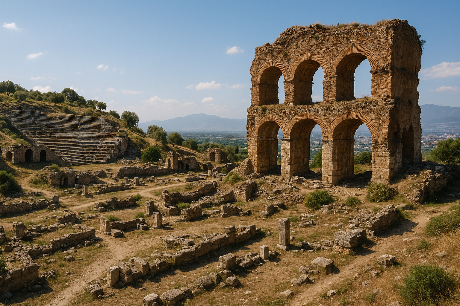
Alabanda (más tarde conocida como Antioquía de los Crisaorios) fue una de las ciudades más ricas y culturalmente vibrantes de la antigua Caria, situada siete kilómetros al oeste de la actual Cine, en la provincia de Aydin, a orillas del río Marsias (el actual Cine Cayi). Su nombre deriva de la lengua caria --«ala» significa caballo y «banda», victoria-- y la leyenda atribuye su fundación al héroe Alabandos, que ganó una célebre carrera de caballos. Autores antiguos como Cicerón y Estrabón describieron Alabanda como un centro de lujo y decadencia, llamado a veces el «Las Vegas del mundo antiguo». El Templo jónico de Apolo Isótimo, el teatro helenístico con una capacidad estimada de 6.200 espectadores y el bouleuterion rectangular se cuentan entre los restos arqueológicos más significativos del interior de Caria. Excavada por primera vez por Halil Edhem Bey en 1904-1905, el yacimiento se encuentra actualmente bajo una investigación sistemática dirigida por el Prof. Asoc. Dr. Ali Yalcin Tavukcu desde 2015.
Tabla de contenidos
- Por qué importa Alabanda
- Geografía y emplazamiento
- Cronología histórica
- Principales monumentos
- Trabajos arqueológicos
- Información para el visitante
- Preguntas frecuentes
- Fuentes y lecturas complementarias
Por qué importa Alabanda
-
Identidad cultural caria. Alabanda es uno de los yacimientos clave para comprender la civilización caria indígena antes y durante el proceso de helenización. La etimología en lengua caria de su nombre, la leyenda de Alabandos y las prácticas cultuales únicas de la ciudad revelan una cultura distinta de la corriente griega dominante. Caria fue una de las regiones culturalmente más complejas de la antigua Anatolia, y Alabanda se erige como uno de sus centros urbanos más expresivos.
-
Culto al fundador divinizado. Según Cicerón (De Natura Deorum), los ciudadanos de Alabanda veneraban a su legendario fundador Alabandos como un dios: un raro ejemplo de divinización de un fundador cívico que ofrece una visión sobre las prácticas religiosas carias y la formación de la identidad cívica. Esto es notable porque los honores divinos a un fundador mortal eran inusuales en el mundo antiguo y situaban a Alabanda en un selecto grupo de ciudades con tales tradiciones.
-
Reputación de riqueza y lujo. Estrabón (Libro XIV) describió Alabanda como una ciudad conocida por su vida extravagante, su abundancia de espectáculos y una concentración de muchachas tañedoras de arpa. Se dice que la ciudad fue uno de los mayores centros de entretenimiento del mundo helenístico hacia el 350 a. C. Los satíricos antiguos retrataron a sus ciudadanos como entregados al placer por encima de todo, creando una reputación que ha perdurado milenios.
-
Mármol oscuro y piedras preciosas. Las laderas al sur de Alabanda producían un característico mármol violeta oscuro («alabandina») y depósitos de gemas semejantes a granates (también llamados «alabandina»), que se comercializaban por todo el Mediterráneo y otorgaron a la ciudad una dimensión económica adicional más allá de la agricultura. El mineral alabandita (sulfuro de manganeso) toma su nombre de esta ciudad.
-
Arquitectura monumental. El Templo de Apolo Isótimo, el teatro bien conservado con asientos para unos 6.200 espectadores y el bouleuterion rectangular representan algunos de los mejores ejemplos de arquitectura cívica helenística en el interior cario. La calidad de la construcción rivaliza con la de ciudades costeras mayores.
-
Primeras carreras de caballos. Según la tradición local, se afirma que Alabanda es el lugar donde tuvieron lugar las primeras carreras de caballos organizadas del mundo, vinculando la leyenda fundacional de la ciudad directamente a su nombre y a un aspecto importante de la cultura atlética antigua.
Geografía y emplazamiento
Alabanda ocupa una posición estratégicamente favorable en el valle del Cine Cayi (el antiguo río Marsias) en el suroeste de Turquía, dentro de los límites de la actual provincia de Aydin. El yacimiento se encuentra aproximadamente a 7 km al oeste de la localidad de Cine y cerca de la aldea de Doganyurt (antiguamente Araphisar).
Sus características geográficas incluyen:
- Ubicación en valle fluvial a orillas del Marsias, proporcionando agua para la agricultura y un corredor natural de transporte que conectaba el interior cario con el valle del Meandro (Buyuk Menderes) y la costa egea.
- Colinas gemelas que definen la topografía urbana: la ciudad se construyó sobre dos colinas prominentes separadas por una silla, con la acrópolis en la elevación más alta al norte. Esta disposición de colinas gemelas es un rasgo distintivo visible desde una distancia considerable.
- Tierras agrícolas fértiles en el valle circundante, que sostenían el cultivo de cereales, olivares, huertos y, en particular, extensos viñedos que contribuían a la riqueza de la región.
- Canteras de mármol oscuro en las laderas al sur, donde se extraía y exportaba la característica piedra de color negro-violáceo conocida como «alabandina» por todo el mundo mediterráneo.
- Depósitos de gemas que producían piedras parecidas al granate, apreciadas en la joyería y el comercio antiguos.
- Clima mediterráneo con veranos cálidos y secos e inviernos suaves y húmedos: típico del interior del oeste de Anatolia.
Sistema fluvial y rutas comerciales
El río Marsias proporcionaba recursos hídricos esenciales y conectaba Alabanda con una red de ciudades carias del interior que incluía Alinda, Gerga y el gran santuario de Labraunda. El sistema viario también enlazaba la ciudad con el gran centro costero de Mileto a través del valle del Meandro. Esta conectividad significaba que Alabanda, a pesar de su ubicación interior, nunca estuvo aislada de las principales corrientes comerciales y culturales del mundo egeo.
Terreno defensivo
La topografía de colinas gemelas proporcionaba ventajas defensivas naturales. Las pendientes pronunciadas en varios lados reducían la necesidad de murallas extensas, mientras que la silla entre las colinas creaba un espacio natural de reunión que pasó a ser el ágora. La colina de la acrópolis dominaba vistas sobre todo el valle del Marsias, proporcionando una advertencia temprana ante amenazas que se acercaban.
Cronología histórica
Período cario temprano (antes del siglo V a. C.)
- La leyenda fundacional se centra en Alabandos, hijo de Euipo (o del héroe cario Car según algunas tradiciones), que ganó una carrera de caballos (o de carros) y fundó la ciudad en este emplazamiento. La leyenda encapsula la conexión de la ciudad con la cultura ecuestre y la competición.
- El nombre en lengua caria confirma unos orígenes indígenas anteriores a la influencia cultural griega.
- Alabanda formaba parte de la Liga Crisaoria, una federación de ciudades carias centrada en el santuario de Zeus Crisaoreo cerca de Estratonicea.
- La ciudad se desarrolló desde fechas tempranas como un centro regional significativo, beneficiándose de su ubicación en el cruce de rutas comerciales.
Período clásico y helenístico temprano (siglos V-III a. C.)
- La ciudad aparece en los registros históricos desde el siglo V a. C. en adelante, funcionando como un próspero asentamiento cario.
- Hacia el 350 a. C., Alabanda era, según se dice, uno de los mayores centros de entretenimiento del mundo antiguo, desarrollando ya su reputación de lujo y placer.
- Durante las campañas de Alejandro Magno (334-323 a. C.), Caria pasó a control macedonio. La reina caria Ada de Caria buscó inicialmente el apoyo de Alejandro y Alabanda, como otras ciudades carias, se adaptó a la nueva realidad política.
- La ciudad fue posteriormente renombrada Antioquía de los Crisaorios por los reyes seléucidas, reflejando su política de helenización de los nombres de las ciudades, aunque el nombre original Alabanda persistió en el uso común y acabó por reafirmarse.
Período helenístico tardío (siglos II-I a. C.)
- Alabanda quedó bajo influencia de Roma tras la derrota de los seléucidas y la expansión del poder romano hacia Asia Menor.
- En 170 a. C., Alabanda envió embajadores a Roma, demostrando su compromiso diplomático con la superpotencia emergente y su conciencia de las realidades geopolíticas cambiantes.
- El Templo de Apolo Isótimo se construyó en el siglo II a. C., diseñado por el arquitecto anatolio Menestes como un templo jónico con 8 x 13 columnas, de aproximadamente 35 x 22 metros. Una inscripción confirmó que el templo estaba dedicado a Apolo Isótimo («igual en honor» a Zeus Crisaor) y a los emperadores divinos.
- La ciudad siguió prosperando mediante el comercio de mármol, gemas y productos agrícolas.
- Alabanda se hizo conocida por su escuela de retórica, que produjo notables oradores reconocidos en todo el mundo helenístico.
Período imperial romano (siglo I a. C. -- siglo IV d. C.)
- Bajo administración provincial romana (provincia de Asia), Alabanda mantuvo su papel como centro regional con funciones judiciales y administrativas significativas.
- Cicerón (106-43 a. C.) hizo referencia al culto al divinizado Alabandos en sus obras filosóficas, utilizándolo como ejemplo en los debates sobre la naturaleza de los dioses. También mencionó la escuela retórica de Alabanda.
- Estrabón (64 a. C. -- 24 d. C.) describió la reputación de la ciudad por su vida lujosa, observando su abundancia de animadores y su cultura festiva. Comparó Alabanda desfavorablemente con ciudades más sobrias.
- El emperador Adriano visitó Alabanda en 120 d. C., y se descubrieron fragmentos de una estatua de mármol de Adriano en el bouleuterion durante las excavaciones modernas, conmemorando probablemente esta visita imperial.
- La ciudad siguió habitada durante el período romano tardío, pero declinó gradualmente en importancia a medida que las estructuras administrativas cambiaban.
Períodos bizantino y posterior (siglos IV-XIII)
- El asentamiento continuó a escala reducida durante la era bizantina, con cierta conversión de edificios públicos para el culto cristiano.
- La ciudad acabó cayendo bajo control turco tras la Batalla de Manzikert (1071) y la subsiguiente expansión selyúcida en el oeste de Anatolia.
- El yacimiento fue en gran medida abandonado, sirviendo las estructuras restantes como canteras de piedra para los asentamientos cercanos. La aldea de Araphisar (más tarde renombrada Doganyurt) creció junto a las ruinas.
Principales monumentos
Templo de Apolo Isótimo
La estructura religiosa más significativa de Alabanda, este templo fue diseñado por el arquitecto Menestes y construido en el siglo II a. C.. Sus rasgos clave incluyen:
- Columnas de orden jónico dispuestas en una planta de 8 x 13 (disposición pseudo-díptera)
- Dimensiones de aproximadamente 35 x 22 metros
- Una inscripción de dedicación a Apolo Isótimo («igual en honor»), indicando que el estatus de la deidad se elevaba al de Zeus Crisaor, el dios supremo de la Liga Crisaoria
- Una dedicación secundaria a los emperadores divinos (Sebastoi), añadida durante el período romano
- El podio del templo y porciones del estilóbato siguen siendo visibles en el yacimiento
- El arquitecto Menestes es conocido por las fuentes antiguas como un especialista en el diseño de templos anatolios
Teatro helenístico
Excavado en una ladera natural orientada al sur, el teatro es una de las estructuras mejor conservadas de Alabanda:
- Capacidad estimada de aproximadamente 6.200 espectadores según mediciones in situ, lo que lo hace mayor que muchos teatros carios comparables
- La fachada mide aproximadamente 19 metros de ancho
- Las filas de asientos (cávea) se construyeron en mármol, mientras que la estructura de soporte utilizó granito y gneis locales
- La orquesta, las secciones inferiores de asientos y partes del edificio escénico (skene) sobreviven en forma reconocible
- La orientación hacia el sur ofrecía a los espectadores vistas panorámicas sobre el valle del Marsias durante las representaciones
- La acústica del teatro sigue siendo impresionante incluso hoy, como pueden verificar los visitantes
Bouleuterion (Casa del Consejo)
Un edificio cívico rectangular de aproximadamente 26 x 36 metros, situado justo al norte del ágora:
- Servía como sala de reuniones para el consejo de la ciudad (boule)
- Presentaba filas curvas de asientos dentro de la cáscara exterior rectangular, creando un espacio de reunión eficiente
- Letras griegas talladas en bloques individuales de piedra indican el cantero o taller responsable de cada sección: una herramienta inestimable para comprender la gestión y el control de calidad de la construcción antigua
- Aquí se recuperaron fragmentos de una estatua de mármol del emperador Adriano durante las excavaciones, que se cree que conmemoran su visita en el 120 d. C.
- Los cimientos relativamente intactos de la estructura la convierten en un ejemplo importante de la arquitectura cívica helenística
- El bouleuterion ha sido objeto de investigaciones geofísicas mediante prospecciones de resistividad eléctrica
Murallas y puertas
Alabanda estaba rodeada por murallas sustanciales:
- Fuertes muros rodeaban el asentamiento, con tramos aún trazables a lo largo de la ladera
- Una puerta principal es visible justo más allá del ágora al norte
- Los materiales constructivos incluyen piedra local unida con mortero de cal
- Son evidentes múltiples fases de construcción y reparación, que abarcan desde el período helenístico al bizantino
- Las murallas incorporaban los acantilados naturales de las colinas gemelas al circuito defensivo
Ágora (Mercado)
El centro público de la vida cívica y comercial:
- Situada en la silla entre las dos colinas que definen la topografía de la ciudad
- Bordeada por el bouleuterion al norte y el recinto del templo
- Excavada por primera vez en 1904 por Halil Edhem Bey durante las primeras excavaciones arqueológicas
- Basas de columnas dispersas, fragmentos arquitectónicos y losas de pavimento marcan su extensión
- El ágora habría acogido mercados diarios, anuncios públicos, procesos judiciales y reuniones sociales
Complejo gimnasio-termas
Las excavaciones también han revelado cimientos de un complejo gimnasio-termas, típico de las amenidades urbanas helenísticas y romanas, atestiguando la inversión de la ciudad en la salud pública y la cultura atlética. El complejo refleja el ideal urbano mediterráneo de combinar ejercicio físico, baño e interacción social en un único conjunto arquitectónico.
Cisterna antigua
Se ha identificado y estudiado una significativa cisterna subterránea utilizando métodos geofísicos eléctricos y magnéticos (publicado en Arabian Journal of Geosciences, 2018). Esta instalación de almacenamiento de agua demuestra las soluciones ingenieriles empleadas para garantizar el suministro hídrico en el ambiente mediterráneo semiárido.
Trabajos arqueológicos
Excavaciones de época otomana
- El yacimiento fue descrito por primera vez por viajeros europeos en los siglos XVIII y XIX, que observaron el teatro visible, los cimientos del templo y las murallas.
- Las primeras excavaciones arqueológicas formales fueron realizadas por Halil Edhem Bey en 1904-1905, convirtiendo a Alabanda en uno de los yacimientos más tempranamente excavados en Anatolia bajo la erudición de época otomana. Halil Edhem Bey descubrió el ágora y documentó numerosos restos arquitectónicos.
- Arqueólogos franceses también realizaron investigaciones a finales del siglo XIX y principios del XX.
Excavaciones modernas (1999-presente)
- El Museo de Aydin inició excavaciones arqueológicas formales en agosto de 1999, con permiso del Ministerio de Cultura turco. Las temporadas iniciales fueron dirigidas por los funcionarios del museo Emin Yener y el Prof. Asoc. Suat Ateslier.
- Desde 2015, las excavaciones sistemáticas han sido dirigidas por el Prof. Asoc. Dr. Ali Yalcin Tavukcu, de la Universidad de Ataturk, centrándose particularmente en el bouleuterion y sus alrededores.
- Los descubrimientos clave incluyen fragmentos de la estatua de mármol de Adriano procedente del bouleuterion y una mayor clarificación de la inscripción de dedicación del templo.
- Se han aplicado investigaciones geofísicas, incluidas prospecciones de resistividad eléctrica, al bouleuterion para detectar rasgos estructurales subsuperficiales sin excavación invasiva (publicado en Arabian Journal of Geosciences, 2016).
- Estudios geofísicos adicionales sobre la cisterna antigua han ampliado la comprensión de la infraestructura hídrica de la ciudad.
Investigación en curso
- Los trabajos de excavación continúan anualmente, con temporadas recientes que se centran en el área del ágora, una mayor documentación del teatro y la investigación de barrios residenciales.
- El yacimiento se está preparando gradualmente para una mayor afluencia pública, con trabajos de conservación en las estructuras expuestas.
- Las publicaciones académicas siguen refinando la cronología de los monumentos de la ciudad y mejorando la comprensión de su historia económica y social.
- El teatro ha sido documentado por el proyecto Ancient Theatre Archive, contribuyendo a los estudios comparativos de la arquitectura teatral anatolia.
Información para el visitante
Cómo llegar
Alabanda está situada aproximadamente a 7 km al oeste de Cine, una localidad en la autopista Aydin-Mugla (D-550). Desde Cine, siga las señales hacia la aldea de Doganyurt. El yacimiento es accesible en coche; la aproximación final se realiza por una carretera asfaltada pero estrecha.
- Desde Aydin: ~55 km, aproximadamente 1 hora en coche
- Desde Mugla: ~90 km, aproximadamente 1,5 horas en coche
- Desde Izmir: ~180 km, aproximadamente 2,5 horas en coche
- Desde Bodrum: ~120 km, aproximadamente 2 horas en coche
- Desde Denizli/Pamukkale: ~130 km, aproximadamente 2 horas en coche
Mejor época para visitar
- Primavera (marzo-mayo): Temperaturas ideales, paisajes verdes y flores silvestres alrededor de las ruinas. Es la temporada más fotogénica.
- Otoño (septiembre-noviembre): Tiempo agradable y luz dorada de la tarde, excelente para la fotografía y la exploración pausada.
- Verano: Las temperaturas pueden superar los 35 °C en el valle; visite a primera hora de la mañana o al final de la tarde para evitar el peor calor.
- Invierno: Suave pero ocasionalmente lluvioso; el yacimiento tiene menos afluencia y puede visitarse cómodamente en los días secos.
Qué esperar
- El yacimiento es un área de excavación activa con algunas medidas de conservación en marcha.
- Las estructuras clave (teatro, podio del templo, cimientos del bouleuterion) son claramente visibles y accesibles.
- La señalización es limitada; los visitantes se benefician de una investigación previa o de un guía local.
- El terreno implica caminar moderadamente por suelo irregular y laderas.
- Reserve de 2 a 3 horas para una visita exhaustiva.
Consejos prácticos
- Calce zapatos de senderismo resistentes adecuados para terreno rocoso e irregular.
- Lleve agua y protección solar, especialmente en verano.
- La cercana localidad de Cine ofrece restaurantes, cafeterías y alojamiento básico.
- Un buen mapa topográfico o GPS ayuda a navegar por el yacimiento, que se extiende sobre dos colinas.
- El teatro ofrece una excelente acústica: pruébela con un aplauso desde la orquesta.
Combinación con un itinerario de arqueología caria
Alabanda está idealmente situada como parte de una gira arqueológica caria más amplia:
- Alinda (30 km): otra importante ciudad caria con una impresionante sala de mercado de tres pisos y una torre de vigilancia
- Gerga (40 km): remoto santuario cario con relieves antropomorfos monumentales
- Labraunda (50 km): santuario de Zeus Labraundos, uno de los lugares carios más sagrados, con un espectacular emplazamiento de montaña
- Euromos (60 km): uno de los templos corintios mejor conservados de Turquía
- Estratonicea (55 km): importante ciudad caria con excavaciones en curso y una impresionante capa de época selyúcida
- Localidad de Cine: localidad-mercado local con carácter anatolio tradicional y hospitalidad
Preguntas frecuentes
¿Qué significa el nombre Alabanda?
El nombre procede de la lengua caria: «ala» significa caballo y «banda», victoria (o competición). Se dice que el legendario fundador Alabandos ganó una carrera de caballos y fundó la ciudad en el lugar de su triunfo. Se afirma a veces que la ciudad es el lugar donde se celebraron las primeras carreras de caballos organizadas del mundo.
¿Por qué se llamó a Alabanda el «Las Vegas del mundo antiguo»?
Los escritores antiguos, en particular Estrabón, describieron Alabanda como una ciudad de lujo, entretenimiento y vida hedonista. Hacia el 350 a. C., se dice que fue uno de los mayores centros de entretenimiento del mundo conocido, con abundancia de músicos, bailarinas y cultura festiva. Esta reputación ha llevado a los comentaristas modernos a establecer la comparación con las capitales del entretenimiento moderno.
¿Qué es el mármol y la piedra «alabandina»?
El mármol violeta oscuro extraído cerca de Alabanda se conocía como «alabandina» y era apreciado en todo el Mediterráneo antiguo con fines decorativos. Además, las piedras semipreciosas semejantes al granate procedentes de la región también se llamaban «alabandina»: ambas otorgaron a la ciudad una identidad material distintiva en el comercio antiguo. El nombre mineralógico moderno «alabandita» (sulfuro de manganeso) también deriva de esta ciudad.
¿Quién era Apolo Isótimo?
Apolo Isótimo significa literalmente «Apolo igual en honor». El epíteto indica que Apolo en Alabanda fue elevado a un estatus igual al de Zeus Crisaor, la deidad suprema de la Liga Crisaoria de ciudades carias. Esta elevación teológica única refleja el deseo de Alabanda de afirmar su importancia religiosa y política dentro de la confederación caria.
¿Qué tamaño tenía el teatro?
El teatro de Alabanda tenía una capacidad estimada de aproximadamente 6.200 espectadores según mediciones in situ. Se trata de un tamaño sustancial para una ciudad caria del interior y subraya la importancia de Alabanda como centro regional de entretenimiento y cultura.
¿Qué dijo Cicerón sobre Alabanda?
En De Natura Deorum (Sobre la naturaleza de los dioses), Cicerón menciona que las gentes de Alabanda veneraban a su legendario fundador Alabandos como un ser divino. Lo utilizó como ejemplo filosófico en las discusiones sobre lo que constituye un dios, cuestionando si la mera devoción cívica podía crear divinidad.
¿Quién excavó Alabanda por primera vez?
Halil Edhem Bey realizó las primeras excavaciones arqueológicas formales en 1904-1905 bajo la erudición de la época otomana. Descubrió el ágora y documentó numerosos restos arquitectónicos que siguen siendo importantes puntos de referencia hoy.
¿Visitó el emperador Adriano Alabanda?
La evidencia sugiere que sí. Los fragmentos de una estatua de mármol de Adriano hallados en el bouleuterion se cree que conmemoran su visita a la ciudad en 120 d. C., durante uno de sus extensos recorridos por las provincias orientales.
El contexto cario
Alabanda pertenece al rico paisaje arqueológico de la antigua Caria, una de las regiones culturalmente más complejas del suroeste de Anatolia. Comprender Alabanda requiere apreciar su lugar dentro del mundo cario.
Los carios eran un pueblo anatolio indígena con su propia lengua, escritura y tradiciones religiosas. Aunque se helenizaron progresivamente desde el siglo VI a. C. en adelante, mantuvieron prácticas culturales distintivas, incluido el culto a Zeus Crisaoreo en Estratonicea, la veneración de fundadores-héroes locales como Alabandos y el uso de su propia lengua en inscripciones hasta bien entrado el período helenístico.
La Liga Crisaoria, a la que pertenecía Alabanda, era una institución política exclusivamente caria. A diferencia de las ligas griegas, que solían estar dominadas por una sola ciudad, la Liga Crisaoria era una federación laxa de ciudades unidas por el culto compartido a Zeus Crisaoreo. La elevación por parte de Alabanda de Apolo Isótimo a un estatus «igual en honor» con Zeus Crisaor representa una audaz declaración teológica y política sobre la importancia de la ciudad dentro de esta confederación.
La prosperidad económica de Alabanda se basaba en una base diversa: agricultura (en particular viticultura y cultivo del olivo), extracción de mármol, extracción de gemas y su posición en las rutas comerciales que conectaban el interior con la costa egea. Esta diversidad económica ayuda a explicar la resiliencia de la ciudad y su capacidad para sostener el programa de construcción monumental que produjo el templo, el teatro y el bouleuterion.
La reputación de la ciudad por el lujo y el entretenimiento, aunque a veces exagerada por los satíricos antiguos, refleja un fenómeno cultural genuino: ciudades carias como Alabanda, Afrodisias y Mylasa eran lo bastante ricas como para sostener extensas culturas festivas, tradiciones musicales y patronazgo artístico que rivalizaban con las grandes ciudades de la Grecia continental.
Los visitantes interesados en explorar el paisaje arqueológico cario más amplio pueden crear itinerarios de varios días que enlacen Alabanda con Alinda, Labraunda, Euromos, Estratonicea, Heracleia en el Latmos y Afrodisias: cada una ofrece perspectivas únicas sobre diferentes aspectos de la civilización caria.
La escuela de retórica
Las fuentes antiguas mencionan que Alabanda albergaba una notable escuela de retórica, que producía oradores reconocidos en los mundos helenístico y romano. La existencia de tal escuela en una ciudad del interior cario subraya la profundidad de la penetración cultural griega y la importancia de la educación retórica en la vida cívica antigua. La capacidad de hablar de manera persuasiva en las asambleas públicas y los tribunales se consideraba esencial para la participación política, y las ciudades que producían oradores distinguidos ganaban un considerable prestigio.
Economía y acuñación
La prosperidad de Alabanda se construyó sobre una economía diversificada que combinaba agricultura, comercio y extracción de piedra. El fértil valle del río Marsias (Cine) sostenía el cultivo de cereales, olivos y uvas, mientras que la posición de la ciudad en las principales rutas interiores la convertía en un centro comercial. Alabanda acuñó su propia moneda desde el período helenístico, con emisiones tempranas que llevaban la imagen de Pegaso y monedas posteriores del período romano con la cabeza del Senado o retratos imperiales. Estas monedas circularon ampliamente por todo el oeste de Anatolia, atestiguando el alcance económico de la ciudad.
Las canteras locales de mármol oscuro proporcionaron piedra de construcción no solo para la propia arquitectura monumental de Alabanda, sino también para la exportación a otras ciudades de la región. Estrabón observó que el mármol de Alabanda era particularmente apreciado. Se han identificado elementos arquitectónicos tallados con esta característica piedra oscura en yacimientos de toda Caria. La combinación de riqueza agrícola, ingresos comerciales e ingresos por la cantera otorgó a Alabanda los recursos financieros para construir los impresionantes edificios públicos cuyas ruinas todavía salpican hoy el yacimiento.
Infraestructura hídrica
Alabanda poseía un sofisticado sistema de gestión del agua que incluía:
- Un importante acueducto que llevaba agua desde fuentes de altura a la ciudad
- Cisternas subterráneas para almacenamiento de agua durante los meses secos del verano
- Una red de tuberías de arcilla que distribuía el agua a fuentes públicas y termas
- Canales de drenaje bajo las calles principales para gestionar las aguas pluviales
Las recientes prospecciones geofísicas han revelado el alcance completo de esta infraestructura hidráulica, demostrando las capacidades ingenieriles de los planificadores de la ciudad.
Evidencia numismática y tipología de monedas
Alabanda mantuvo una ceca activa desde el período helenístico hasta el imperial romano, produciendo una acuñación distintiva que refleja la identidad cultural, las alianzas políticas y el alcance económico de la ciudad. El registro numismático proporciona algunas de las evidencias cronológicas más precisas para la historia de Alabanda.
Acuñación helenística
| Denominación | Rango de fechas | Patrón | Peso | Diámetro | Anverso | Reverso |
|---|---|---|---|---|---|---|
| AR Tetradracma (tipo alejandrino) | c. 173--167 a. C. | Ático | 16,07--16,21 g | 33--34 mm | Cabeza de Heracles con piel de león | Zeus sentado, sosteniendo águila; Pegaso en el campo izquierdo |
| AR Tridracma | Después del 168 a. C. | Rodio | c. 10,5 g | 25--28 mm | Cabeza de Apolo | Pegaso encabritado |
| AR Didracma | Después del 168 a. C. | Rodio | c. 6,5--7,0 g | 20--24 mm | Cabeza de Apolo | Pegaso volando hacia la izquierda |
| AR Octobolos | Después del 168 a. C. | Rodio | c. 4,2 g | 18--20 mm | Cabeza de Apolo | Pegaso |
Tras la declaración del Senado romano de libertad para Caria y Licia en 168 a. C., Alabanda comenzó a acuñar tetradracmas del tipo alejandrino junto a sus propias denominaciones cívicas. El tipo monetario más distintivo de la ciudad --Pegaso (el caballo alado)-- aparece de manera constante en todas las denominaciones y períodos, vinculándose directamente con la leyenda fundacional de Alabandos y su victoria en la carrera de caballos.
La ciudad también produjo una notable serie de tetradracmas cívicos datados c. 197--190/188 a. C. con un busto de Apolo en el anverso y un Pegaso encabritado en el reverso. Estas monedas circularon ampliamente y se han hallado en tesoros por todo el oeste de Anatolia y las islas orientales del Egeo.
Acuñación imperial romana
Durante el período imperial romano, Alabanda siguió acuñando moneda cívica de bronce con:
- Anverso: retratos imperiales (desde Augusto hasta la dinastía severa) o personificación del Senado romano (IEPA CYNKΛHTOC)
- Reverso: imágenes cultuales locales que incluyen Apolo, Pegaso y representaciones del Templo de Apolo Isótimo
- Leyendas: inscripciones griegas que identifican la ciudad como ΑΛΑΒΑΝΔΕΩΝ (de los alabandeos)
Estudio arquitectónico: dimensiones medidas de los principales monumentos
El detallado trabajo de prospección en Alabanda ha producido mediciones precisas de las principales estructuras de la ciudad, permitiendo la comparación con otros centros urbanos carios.
| Estructura | Dimensiones | Configuración de columnas | Material | Período |
|---|---|---|---|---|
| Templo de Apolo Isótimo | 35 x 22 m | Pseudo-díptero, 8 x 13 columnas jónicas | Mármol local + piedra oscura alabandina | Siglo II a. C. |
| Ágora | 112 x 72 m | Estoas con columnata en al menos dos lados | Caliza + mármol | Helenístico--Romano |
| Bouleuterion | 26 x 36 m (exterior) | Asientos interiores curvos dentro de cáscara rectangular | Granito, gneis, mármol | Helenístico |
| Teatro | c. 90 m diámetro de cávea | Capacidad para 6.200 espectadores | Asientos de mármol; subestructura de granito/gneis | Helenístico |
| Murallas | Trazables c. 3,5 km de circuito | Torres a intervalos irregulares | Piedra local con mortero de cal | Helenístico--Bizantino |
El Templo de Apolo Isótimo, diseñado por el arquitecto Menestes, empleó una planta pseudo-díptera: una configuración en la que se omite el anillo interior de columnas, creando un amplio deambulatorio alrededor de la cella. Esta elección de diseño, también utilizada en el Templo de Artemisa en Magnesia (por Hermógenes), refleja una preferencia arquitectónica anatolia por los interiores espaciosos en los templos y puede haber estado destinada específicamente a acoger grandes reuniones ceremoniales de la Liga Crisaoria.
Resultados de la investigación geofísica
Los métodos geofísicos modernos aplicados en Alabanda han revelado estructuras subsuperficiales sin excavación invasiva:
| Método de prospección | Objetivo | Publicado en | Hallazgos clave |
|---|---|---|---|
| Tomografía de resistividad eléctrica (ERT) | Cimientos del bouleuterion | Arabian Journal of Geosciences, 2016 | Detección de muros y niveles de suelo enterrados bajo los restos visibles; confirmación de construcción multifase |
| Prospección eléctrica + magnética | Cisterna antigua | Arabian Journal of Geosciences, 2018 | Cartografía completa de una cámara subterránea de almacenamiento de agua previamente desconocida; volumen y técnica constructiva estimados |
| Georradar (GPR) | Zona del ágora | En curso (década de 2020) | Detección preliminar de basas de columnas enterradas y posibles cimientos de tiendas a lo largo del perímetro del ágora |
Estas técnicas no invasivas han demostrado ser particularmente valiosas en Alabanda, donde aún quedan extensas áreas sin excavar. Las prospecciones de resistividad del bouleuterion confirmaron que los restos visibles representan solo la fase superior de un edificio cívico multiperíodo, con fases constructivas anteriores enterradas debajo.
Cronología de excavaciones: registro completo
| Período | Director / Equipo | Actividades clave |
|---|---|---|
| Siglos XVIII--XIX | Viajeros europeos (Chandler, Fellows, otros) | Primeras descripciones y bocetos de las ruinas visibles |
| 1904--1905 | Halil Edhem Bey | Primera excavación formal; descubrimiento del ágora, documentación del teatro y los cimientos del templo |
| Finales del siglo XIX -- principios del XX | Arqueólogos franceses | Trabajos de prospección y excavación limitada |
| Agosto de 1999 | Museo de Aydin (Emin Yener, Suat Ateslier) | Comienzan las excavaciones modernas; documentación sistemática del teatro, ágora y recinto del templo |
| 2015--presente | Ali Yalcin Tavukcu (Universidad de Ataturk) | Excavación focalizada del bouleuterion y sus alrededores; descubrimiento de fragmentos de la estatua de Adriano; prospecciones geofísicas; programa de conservación |
Fuentes y lecturas complementarias
- Wikipedia -- Alabanda
- Livius.org -- Alabanda
- Turkish Museums -- Aydin Alabanda Archaeological Site
- Turkish Museums -- Alabanda Archaeological Site and the Legend of Kizlarhisari
- Alabanda Tourism -- Ancient City of Alabanda
- Destinations.com.tr -- Alabanda: Exploring the Ancient City of Horse Races and Luxury
- Slow Travel Guide -- Alabanda Ancient Site
- Hurriyet Daily News -- Alabanda, the Las Vegas of the Ancient World
- Ancient Theatre Archive -- Alabanda
- Cicerón, De Natura Deorum -- referencias al culto de Alabandos
- Estrabón, Geografía, Libro XIV -- descripción del lujo y la cultura de Alabanda
- World History Encyclopedia -- Top 10 Archaeological Sites in Caria
- Arabian Journal of Geosciences -- estudios geofísicos en el bouleuterion y la cisterna de Alabanda